These maps are for the birds
•Descargar como PPTX, PDF•
1 recomendación•620 vistas

Wildlife atlas maps available online provide opportunities to reinforce geography skills while learning about New York wildlife. Steve Stanne (NYS DEC's Hudson River Estuary Program) shares bird, reptile, and amphibian maps to show where different species live and how their distributions changed over time. Grades 4-8.

Recomendados
Más contenido relacionado
Destacado
Destacado (19)
Similar a These maps are for the birds
Similar a These maps are for the birds (20)
Más de Teaching the Hudson Valley
Más de Teaching the Hudson Valley (20)
Último
Último (20)
These maps are for the birds
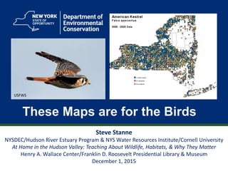
- 1. 1 These Maps are for the Birds Steve Stanne NYSDEC/Hudson River Estuary Program & NYS Water Resources Institute/Cornell University At Home in the Hudson Valley: Teaching About Wildlife, Habitats, & Why They Matter Henry A. Wallace Center/Franklin D. Roosevelt Presidential Library & Museum December 1, 2015 USFWS
- 3. 3
- 5. 5 New York State Breeding Bird Atlas 1980-1985 2000-2005 http://www.dec.ny.gov/animals/7312.html
- 6. 6 Breeding Bird Atlas Blocks
- 8. 8
- 9. 9
- 10. 10
- 11. 11 USFWS
- 13. 13 SC DNR
- 14. 14 PBS
- 15. 15 Steve Stanne
- 16. 16 Mike Pogue
- 17. 17 USFWS
- 18. 18 Mike Pogue
- 20. 20
- 23. 23
- 24. 24
- 25. 25
- 26. 26
- 27. 27
- 28. 28
- 29. 29
- 30. 30 Check out range changes for your favorite species http://www.dec.ny.gov/cfmx/extapps/bba/ Mike PogueMike Pogue
- 32. 32 S Salant
- 34. 34
- 35. 35
- 36. 36
- 38. 38
- 40. 40 1/11/04 - Sprout Brook, HRM 43.5: At first light we fished, chilled to the bone, on five inches of black flint ice. On the bare branches of a nearby shaggy white pine were nine black vultures, all perched in a row in their night roost, watching us, looking like a convention of undertakers. The air temperature was +1°F. Not a good morning to be a vulture. If they had any sense they'd be in Virginia looking for roadkill. - Tom Lake, Christopher Letts Hudson River Almanac Mike Pogue
- 41. 41 Thank You Steve Stanne, Education Coordinator NYSDEC/Hudson River Estuary Program in cooperation with the NYS Water Resources Institute at Cornell University 21 South Putt Corners Road New Paltz, NY 12561 stephen.stanne@dec.ny.gov 845 256-3077 Connect with us: Facebook: www.facebook.com/NYSDEC Twitter: twitter.com/NYSDEC Flickr: www.flickr.com/photos/nysdec
- 42. 42
Notas del editor
- Wildlife information available on DEC website – click on hyperlink to visit
- Many fact sheets available
- Bird, reptile and amphibian (“herp”), and fish atlases on the DEC website present information about distribution of these animals in map format. Interpretation builds students’ geography and biology skills and understandings.
- The Breeding Bird Atlas also presents change over time, as the field work was conducted in two time periods 20 years apart.
- Information on the maps is presented in blocks covering one quarter of a USGS topographic map. Website allows one to use Google Earth to locate the block covering a particular county or town.
- This is the breeding bird altas interface, offering access to species lists for each block and the maps showing breeding bird distribution for each time period.
- This closeup view shows the information available
- Once you have a block number for a town, you can use it to see a list of the species observed there.
- Look up species by using either an alphabetical list of bird names or by families listed taxonomically in “checklist order” based on when scientists think the family first appeared.
- The black-capped chickadee is widely distributed across New York State.
- On the other hand, the boreal chickadee breed only in the Adirondack Mountains.
- Based on the map, where do least terns like to nest?
- Where do blackpoll warblers like to nest?
- Since data was collected in two time periods 20 years apart, we can see whether a bird’s nesting range changed over time. Have students predict whether the breeding range of the Canada goose changed and how, then Click to see data from 2000-2005.
- How might the peregrine falcon’s breeding range have changed over the 20 years?
- How about the ring-necked pheasant’s range? Loss of grassland and hedgerows along fields has reduced the range of this species, especially in the lower Hudson Valley.
- As its name suggests, the Carolina wren is a southern bird. Do you think its range in NY increased between the 1980s and 2000s? Why?
- The National Audubon Society has created online maps showing how bird distribution is likely to change due to climate change. You can search for lists of species included by state.
- These maps show how the range of the common loon is predicted to change between 2000 and 2080. Note that the yellow area in Adirondacks, showing that the loon nests there now, is gone by 2080.
- Other nearby states have also created breeding bird atlases. Massachusetts adds a map showing whether the nesting population of a species has increased, remained stable, or decreased over time.
- The These Maps are for the Birds lesson plan reviews the material covered in the previous slides. Teacher and student versions are available on DEC’s website; use the hyperlink above to find links to this lesson.
- See teacher section of These Maps Are For The Birds lesson for answers.
- See teacher section of These Maps Are For The Birds lesson for answers.
- See teacher section of These Maps Are For The Birds lesson for answers.
- See teacher section of These Maps Are For The Birds lesson for answers.
- See teacher section of These Maps Are For The Birds lesson for answers.
- See teacher section of These Maps Are For The Birds lesson for answers.
- Explore the data in the breeding bird atlas to find out what’s been going on with some of your favorite birds, maybe the bluebird, scarlet tanager, or red-bellied woodpecker.
- Reptile and amphibian distribution in New York State is shown in DEC’s “herp” atlas. Unlike the bird atlas, it does not show change over time.
- Herp atlas coverage is coarser than breeding bird atlas coverage; it’s based on entire USGS topo maps, not a quarter section of each.
- The Mapping Where Animals Live lesson plan explores DEC’s herp atlas. It is intended for a somewhat younger audience than the lesson These Maps Are For The Birds. Teacher and student versions are available on DEC’s website; use the hyperlink above to find links to this lesson.
- See teacher section of Mapping Where Animals Live lesson for answers.
- See teacher section of Mapping Where Animals Live lesson for answers.
- See teacher section of Mapping Where Animals Live lesson for answers.
- Many websites present information about animal distribution and movements using maps. Journey North has information about many species, and welcomes data from students on sightings – in this case, of monarch butterflies. Click to see how the map shows the monarch’s migration south in fall 2015.
- Ebird collects data from thousands of birders (birdwatchers) across the country. The data is presented in maps to show the distribution and movements of birds in quite up to date fashion.
- In this example, Ebird maps show the movement of snowy owls south in fall 2015.
- The Hudson River Almanac is a free weekly journal of natural history observations from the Hudson Valley, covering all sorts of fish and wildlife. To learn more about it and see sample issues, click on the hyperlink in the slide title or visit http://www.dec.ny.gov/lands/25608.html