Submit Search
Upload
GeovisMtStHelens2
•
0 likes
•
158 views
T
Tommy Goutos
Follow
Report
Share
Report
Share
1 of 1
Download now
Download to read offline
Recommended
This week at Oceanology Americas we presented a paper on SLAM and Optimal Sensor Fusion and outlined how we have implemented this within our real-time navigation and 3D reconstruction tool, 3D Recon. We have just assembled two 4,000m rated 3D Recon systems. One of these systems is currently undergoing pressure cycle testing while the other is undergoing extensive burn-in testing to ensure long term viability. We expect to have test tank data later in March, so if you'd like to receive some sample data sets please let us know at sales@zupt.com.
Zupt, LLC's SLAM and Optimal Sensor fusion
Robert Flaming, PCM®
data capturing techniques - satellite and aerial images
5. lecture 4 data capturing techniques - satellite and aerial images
FenTaHun6
data capturing techniques - satellite and aerial images
5. lecture 4 data capturing techniques - satellite and aerial images
FenTaHun6
Tugas Mata Kuliah Pemetaan Lanjut dari Dr. Ir. Priyono Nugroho, MS Email ke yanto_budisusanto@yahoo.com atau yanto_b@geodesy.its.ac.id untuk permintaan file
Mobile mapping system
Yanto Budisusanto
GPS Satellite
Satellite communication (bett 4803)
Saravanan Sukumaran
introduction for mobile mapping
Mobile mapping
Mobile mapping
Moumen Sherif
Satellites are becoming as useful as any other global infrastructure. The main three application: imaging, communications and navigation are expanding very fast paving the way for the "New Space" firms bringing space tourism, space minerals excavation and space fueling to become a reality for humanity
Space and Satellites
David Zusiman
Presentation at Joint Urban Remote Sensing Event, 6-8 March 2017, Dubai, UAE.
Vehicle Positioning in the Absence of GNSS Signals: Potential of Visual-Inert...
Kourosh Khoshelham
ifo about gps
Gps introduction
Gps introduction
Shafiq Ridz
Wrap-up slide deck on functions developed for the Unmanned Rotorcraft ARITS' Mission Planning and Execution Framework (MiPlEx) as well as a preliminary outlook into adaptations to (unmanned) fixed-wing aircraft kinematics.
Mission Planning and Execution for the Unmanned Rotorcraft ARTIS
Florian-Michael Adolf
徐偉城(達雲科技 總經理) 《DSP 資料開竅.企業論壇》2015.08.21 https://dsp.im/dsp_smart_data_forum/
用光達點雲秀3D
用光達點雲秀3D
DSP智庫驅動
guilluig,cdyifu
Mobile mapping terminology
Faculty of Engineering, Alexandria University, Egypt
Starter Guide for Local Government Units (LGUs) This guide is for Local Government Unit (LGU) readers. The topics contained here are meant to provide information on how Business Mapper products can be applied to your unit.
Introduction to Digital Maps
Paperless Trail Inc.
Galileo gnss
Galileo gnss
Goran Vojkovic, Ph.D.
OPENSTREETMAP Basic Operations
Lesson 1. OPENSTREETMAP Basic Operations
gicait ait
GPS(Global Positioning System)
Asheem Kumar Palo
Panel discussion on Geospatial Intelligence for #LetsTalkDeepTech Webcast 18 April, 2020
Location Intelligence from Imagery
UjavalGandhi
mapping water features using radar SAR imagery, example using ALOS PALSAR RTC Product, free download at ASF VERTEX
Mapping Water features from SAR Imagery
bramantiyo marjuki
Kenyan case.
Engineering survey in the construction industry
noah kertich
Feature list of release 1 mobile mapping solution. Release date Q3 2011, mor info on www.geo.admin.ch
Mockup mobile.map.geo.admin.ch
geoportal of the federal authorities of the Swiss Confederation
In this MWC/ADC 2013 presentation Vaughan Knight, Developer Technical Support Manager at Nokia, provides an overview to the new mapping and location features in Windows Phone 8. These features include a new map control that no longer requires a key, support for offline maps, and pedestrian landmark among others. He then looks at coding map and location apps with the new control and geolocator before showing you how to launch Nokia Direction and Nokia drive from your app as well as use the offline features. For more information see www.developer.nokia.com/windowsphone or http://www.developer.nokia.com/Resources/Library/Lumia/#!guide-to-the-wp8-maps-api.html. Find out more about the developer features of Nokia Lumia smartphones in the Lumia App Labs: http://www.developer.nokia.com/Develop/Windows_Phone/Learn/
MWC/ADC 2013 Mapping and Location for Windows Phone
Microsoft Mobile Developer
Links are given for amazing videos on Floods and Landslides. A project for Remote Sensing and GIS Applications...
Floods & Landslides
Floods & Landslides
Hara Bhara Pakistan
Mapping wild species in Jabal Samhan Nature Reserve, Oman.
Edmundo Garron
map creation using gps locations
Columbus - map creation using gps locations
Aishwarya Kaneri
This presentation discuss about Arc Geographic Information System (GIS) Digital Elevation Models (DEM). DEM data sources.
Arc Geographic Information System (GIS) Digital Elevation Models (DEM).
Uday Kumar Shil
3D Animation
3D Animation
Sheng GUAN
Modern Surveying M.Shanmugaraj M.E., Lecturer / Civil V.S.V.N Polytechnic College Virudhunagar - 626001
Modern Surveying
Modern Surveying
Shanmugaraj M
CasinoMine
CasinoMine
Tommy Goutos
NewfoundlandProject3
Tommy Goutos
GPSvsSurveyFINAL
GPSvsSurveyFINAL
Tommy Goutos
More Related Content
What's hot
ifo about gps
Gps introduction
Gps introduction
Shafiq Ridz
Wrap-up slide deck on functions developed for the Unmanned Rotorcraft ARITS' Mission Planning and Execution Framework (MiPlEx) as well as a preliminary outlook into adaptations to (unmanned) fixed-wing aircraft kinematics.
Mission Planning and Execution for the Unmanned Rotorcraft ARTIS
Florian-Michael Adolf
徐偉城(達雲科技 總經理) 《DSP 資料開竅.企業論壇》2015.08.21 https://dsp.im/dsp_smart_data_forum/
用光達點雲秀3D
用光達點雲秀3D
DSP智庫驅動
guilluig,cdyifu
Mobile mapping terminology
Faculty of Engineering, Alexandria University, Egypt
Starter Guide for Local Government Units (LGUs) This guide is for Local Government Unit (LGU) readers. The topics contained here are meant to provide information on how Business Mapper products can be applied to your unit.
Introduction to Digital Maps
Paperless Trail Inc.
Galileo gnss
Galileo gnss
Goran Vojkovic, Ph.D.
OPENSTREETMAP Basic Operations
Lesson 1. OPENSTREETMAP Basic Operations
gicait ait
GPS(Global Positioning System)
Asheem Kumar Palo
Panel discussion on Geospatial Intelligence for #LetsTalkDeepTech Webcast 18 April, 2020
Location Intelligence from Imagery
UjavalGandhi
mapping water features using radar SAR imagery, example using ALOS PALSAR RTC Product, free download at ASF VERTEX
Mapping Water features from SAR Imagery
bramantiyo marjuki
Kenyan case.
Engineering survey in the construction industry
noah kertich
Feature list of release 1 mobile mapping solution. Release date Q3 2011, mor info on www.geo.admin.ch
Mockup mobile.map.geo.admin.ch
geoportal of the federal authorities of the Swiss Confederation
In this MWC/ADC 2013 presentation Vaughan Knight, Developer Technical Support Manager at Nokia, provides an overview to the new mapping and location features in Windows Phone 8. These features include a new map control that no longer requires a key, support for offline maps, and pedestrian landmark among others. He then looks at coding map and location apps with the new control and geolocator before showing you how to launch Nokia Direction and Nokia drive from your app as well as use the offline features. For more information see www.developer.nokia.com/windowsphone or http://www.developer.nokia.com/Resources/Library/Lumia/#!guide-to-the-wp8-maps-api.html. Find out more about the developer features of Nokia Lumia smartphones in the Lumia App Labs: http://www.developer.nokia.com/Develop/Windows_Phone/Learn/
MWC/ADC 2013 Mapping and Location for Windows Phone
Microsoft Mobile Developer
Links are given for amazing videos on Floods and Landslides. A project for Remote Sensing and GIS Applications...
Floods & Landslides
Floods & Landslides
Hara Bhara Pakistan
Mapping wild species in Jabal Samhan Nature Reserve, Oman.
Edmundo Garron
map creation using gps locations
Columbus - map creation using gps locations
Aishwarya Kaneri
This presentation discuss about Arc Geographic Information System (GIS) Digital Elevation Models (DEM). DEM data sources.
Arc Geographic Information System (GIS) Digital Elevation Models (DEM).
Uday Kumar Shil
3D Animation
3D Animation
Sheng GUAN
Modern Surveying M.Shanmugaraj M.E., Lecturer / Civil V.S.V.N Polytechnic College Virudhunagar - 626001
Modern Surveying
Modern Surveying
Shanmugaraj M
What's hot
(19)
Gps introduction
Gps introduction
Mission Planning and Execution for the Unmanned Rotorcraft ARTIS
用光達點雲秀3D
用光達點雲秀3D
Mobile mapping terminology
Introduction to Digital Maps
Galileo gnss
Galileo gnss
Lesson 1. OPENSTREETMAP Basic Operations
GPS(Global Positioning System)
Location Intelligence from Imagery
Mapping Water features from SAR Imagery
Engineering survey in the construction industry
Mockup mobile.map.geo.admin.ch
MWC/ADC 2013 Mapping and Location for Windows Phone
Floods & Landslides
Floods & Landslides
Mapping wild species in Jabal Samhan Nature Reserve, Oman.
Columbus - map creation using gps locations
Arc Geographic Information System (GIS) Digital Elevation Models (DEM).
3D Animation
3D Animation
Modern Surveying
Modern Surveying
Viewers also liked
CasinoMine
CasinoMine
Tommy Goutos
NewfoundlandProject3
Tommy Goutos
GPSvsSurveyFINAL
GPSvsSurveyFINAL
Tommy Goutos
Ontario
Ontario
Tommy Goutos
DEMFINAL
DEMFINAL
Tommy Goutos
OverlayedGoogleFINAL
Tommy Goutos
3DMap
3DMap
Tommy Goutos
Viewers also liked
(7)
CasinoMine
CasinoMine
NewfoundlandProject3
GPSvsSurveyFINAL
GPSvsSurveyFINAL
Ontario
Ontario
DEMFINAL
DEMFINAL
OverlayedGoogleFINAL
3DMap
3DMap
GeovisMtStHelens2
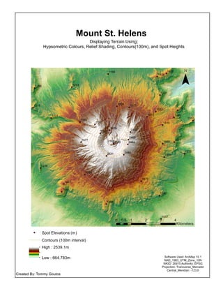
1.
2445 2146 2341 1533 1489 1272 2111 1573 1227 1276 1977 1404 1357 2464 1577 1398 1445 1620 1263 1156 1377 2531 1589 1290 1350 1409 1322 1391 1410 2322 2465 1835 2168 1467 1057 1580 1286 1318 1405 1613 Mount St. Helens Displaying
Terrain Using; Hypsometric Colours, Relief Shading, Contours(100m), and Spot Heights ¯ 0 1 2 3 40.5 Kilometers Created By: Tommy Goutos Software Used: ArcMap 10.1 NAD_1983_UTM_Zone_10N WKID: 26910 Authority: EPSG Projection: Transverse_Mercator Central_Meridian: -123.0 Spot Elevations (m) Contours (100m interval) High : 2539.1m Low : 664.783m
Download now