Geohipster Calendar, May 2018
•
0 recomendaciones•295 vistas

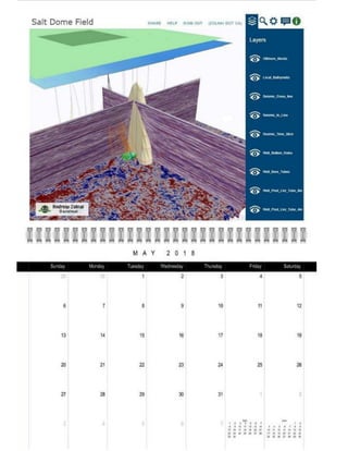
US Gulf of Mexico offshore oilfield 3D web scene: Esri ArcGISPro and WebScene, and Geodata extension. Seafloor bathymetry: Esri data. Well polylines, block and strata polygons, and salt dome multipatch: US BOEM open data and courtesy Eaqle Info Mapping. Seismic _not_ local and courtesy Geodata. Easily accessible web view conflates numerous subsurface data sets in a complex geologic environment, to help localise oil production in rock strata (green) abutting a salt dome (tan). Get you full copy of the calendar here: http://bit.ly/2jlN1ZQl