Understanding Typhoon g8
•Descargar como PPTX, PDF•
17 recomendaciones•3,504 vistas

Learning Competencies: -explain how typhoons develop; - infer why the Philippines is prone to typhoons; -explain how landmasses and bodies of water affect typhoons;

Recomendados
Más contenido relacionado
La actualidad más candente
La actualidad más candente (20)
Similar a Understanding Typhoon g8
Similar a Understanding Typhoon g8 (20)
Más de Anabelle Montevirgen
Más de Anabelle Montevirgen (20)
Último
Último (20)
Understanding Typhoon g8
- 2. Layers of the atmosphere
- 3. •Among the five layers of atmosphere, the troposphere, which is the lowest layer, is exposed to natural phenomena and activities like weather conditions. •The troposphere is the part of the atmosphere where clouds are being formed. This layer consists of water vapor, carbon dioxide, methane, nitrous oxide, and others.
- 4. Tropical Cyclones • The word tropical cyclone is composed of two distinct words that completely describe its characteristics. • “tropical” refers to its geographical starting point, which usually hot and humid. • “Cylone” is a meteorological term which refers to its cyclonic circulation where the strong winds in the Northern Hemisphere circulate counter- clock wise and clock wise in Southern Hemisphere.
- 6. • The tropical cyclone has different name in various part of the world. • Hurricane- if its formed in the North Atlantic Ocean, affecting the Caribbean Sea the most. • Typhoon- when formed in Northwest Pacific Ocean, affecting Southeast Asia- West Philippine Sea and Japan. • Severe Tropical Cyclone in the Southeastern Indian and Southwest pacific Ocean. • Severe Cyclonic storm in the North Indian Ocean • Tropical cyclone in Southwest Indian Ocean
- 7. • The tropical cyclone undergoes a process of development called tropical cyclogenesis. • This process involves several requirements, which, if met, will led to the formation of storm: Warm ocean surface with temperature of 26. 5ºC or 79.7ºF to a depth of at least 50 meters below the surface, which is a favorable environment to maintain a “warm core” that powers up a tropical cyclone.
- 8. Presence of Intertropical Convregence Zone (ITCZ) Greater amount of water vapor in the air (high humidity) in the lower to middle levels of the troposphere Enough Coriolis Force to deflect the converging wind wind is at least 5º of the latitude from the equator, casuing cyclonic rotation and sustaining a low pressure center; A pre-existing low level disturbance or the merging of smaller circulations within ITCZ; and weak vertical wind shear that is less than 10 m/s. Weak vertical wind shear that is less than 10 m/s.
- 10. Classification of Tropical Cyclones since 2009 Tropical cyclones Classification Maximum sustained winds near the center (km/hr) Tropical Depression (TD) <63 Tropical Storm (TS) 63-87 Severe tropical Storm (STS) 88-117 Typhoon (T) 118-149 Severe Typhoon (ST) 150-184 Super Typhoon (SUPER T) 185 or above
- 11. Where tropical Cyclone Originate • From the word “tropical”, the tropical cyclone occurs over warm waters around the world. It develops over large ocean water with a surface temperature of a least 26ºC, about 300 miles (500km) away from the equator. • Most tropical cyclones occur in the area where the Northeasterly and Southeasterl trade winds converge. This area is called ITCZ or Intertropical Convergence Zone, circulating near the eqautor, and is known for its lowest surface pressure, where the converging air ascends (causing “low-pressure” on Earth’s surface.
- 13. Formation and Development of Typhoon • A tropical cyclone always start over a large body of water which is relatively warm. The warm water powers the tropical cyclone. Stage 1: Tropical Disturbance • A tropical disturbance is a discrete weather system of clouds, showers, and thunderstorms, with an apparent circulation the originates in the ocean in the tropical region, and remains intact for 24 hours or more. • It has one type called tropical wave that develops about every 4 t 5 days then becomes tropical storm or hurricane when strengthened. It is sometime called easterly winds or areas of low pressure that normally moves from east to west
- 15. • Stage 2: Tropical Depression The tropical wave or tropical disturbance then evolves into tropical depression when the thunderstorms are slightly more organized. A closed circulation of air in the low levels is developed. The winds blow stronger due to the greater convergence that causes quicker decrease in the pressure. It increases in speed sustaining one-minute winds up to 38mph at an elevation of 10 meters.
- 16. Stage 3: Tropical Storm •The tropical storm receives an official name once sustained winds reach 39 mph in the closed circulation. The winds increase greatly and can take as little as a half day to as much as a couple of days. It has better organized thunderstorms and when viewed in the satellite, it usually shows a recognizable pattern of rotation.
- 17. Stage 4: Typhoon, Hurricane, or Cyclone • As the tropical storm grows more intense, it takes more energy from its surroundings, it develops into a “matured” tropical cyclone which can obtain a one-minute wind at least 74mph at an elevation of 10 meters.
- 18. Other Atmospheric Disturbances May Trigger Typhoon Formation
- 19. 1. Monsoon Trough • It is the trough of low pressure and it’s the most common mechanism that causes typhoon. It is a portion of the ITCZ which extends where cyclonic spin is developed.
- 20. 2. Tropical Upper Tropospheric (TUTT) •-commonly known as Western Hemisphere or “upper cold low,” is an upper atmospheric trough that enhances convection in the tropics and can occasionally promote intensification in the tropical cyclone into typhoon by providing additional force that rises near the storm center and allows an efficient outflow channel in the upper trosphere.
- 21. 3. Easterly Waves • - is an inverted trough of low pressure moving generally westward in the tropical easterlies.
- 22. 4 West African Disturbance Line (WADL) •- is a line of convection, similar to a line of unstable atmospheric environment that develops along or ahead of a cold front (squall line), which forms over West Africa and moves into the Atlantic Ocean. WADL’s usually move faster than tropical waves.
- 23. 5.Old Frontal Boundary •-Fragments of a polar front can become lines of convection and sometimes generate a tropical cyclone. In the Atlantic Ocean storms, this normally occurs early or late in the hurricane season in the Gulf of Mexico or Caribbean sea.
- 25. 1. Cold Waters •The absence of moisture from warm ocean waters means the absence of typhoon’s ‘fuel” source once it lacks its access to this kind of environment. •Typhoons depend on warm air to maintain themselves but when the storm moves over cold water, it loses its energy source, which is the evaporating water from the warm ocean surface.
- 26. 2. No Water •A typhoon will drastically deteriorate once its eye moves over the land. The air over land cools quickly due to the specific heat causing the typhoon too quickly lose intensity. The typhoon usually shows down until it weakens and due to the weakening process, the eye closes in upon itself which causes the areas of low pressure area to become disorganized.
- 27. 3. Wind Shear • Wind shear refers to the difference between the speed shear (wind speed) and its directional shear over a relatively short distance within in the atmosphere. • There is a general rule that states that the shear must be 20 knots or less for intensification to happen.
- 28. Why Is The Philippines Prone To Typhoons?
- 29. • Philippine map shows how the Philippine to typhoon
- 30. • The Philippines is an archipelago consisting of 7,107 islands, surrounded by warm waters from the Pacific ocean, which is suitable for the development of low – pressure system that leads to typhoons. • The distance of the Philippine from the equator is the best site for the Coriolis effect, an apparent force that spins the cyclone
- 31. The Role of PAGASA • The Philippine Atmospheric, Geophysical, and Astronomical Services Administration or PAGASA is a national service institution under the Department of Science and Technology (DOST).
- 32. PAGASA tasked to do the following: Monitor the weather and climate of the country; Provide information to the public about typhoon and flood warnings; Deliver weather forecasts and advisories; And provide facts related to climatology, meteorology, and astronomy
- 33. The Public Storm Warning Signals (PSWS) • The Public Storm Warning Signals (PSWS) are hoisted before the corresponding meteorological conditions prevail over the locality.
- 34. WEATHER EQUIPMENT USED FOR WEATHER MONITORING
- 35. 1. Doppler Weather Radars •These are installed in some strategic locations in the Philippines for closely monitoring of the movements of typhoons, the amount of rainfall, and other atmospheric conditions everyday.
- 36. 2. Automated Rain Gauge •It keeps track of excess rainfall to provide necessary warning signals, whether such rainfall can causes flashfloods or landslides.
- 37. 3. Landslide Early Warning Sensors (LEWS) •These are invented by the University of the Philippines and are used to pick up signals which can be read by the computer to show the movement of the soil and ground. This is an effective tool which can help reduce the risks of landslide incidents.
- 38. 4. Automated Weather Station •This is adopted by the Philippine Weather Bureau and the Department of Science and technology which work jointly to monitor the amounts of rainfall and flood levels. This tool is designed to produce incoming warming in the form of sirens to signal the public for evacuation.
- 39. HOW LANDFORMS AND BODIES OF WATER AFFECT TYPHOON
- 40. Typhoon • PAR
- 41. Other Local Storm in the Philippines • One of the common local storms in the Philippines is thunderstorm, which usually happens during warm and very humid weather, and experienced during mid and late afternoon in a small area. • Thunderstorm are short –live but are always associated with thunder and lightning. • Tornadoes also occur in the Philippines
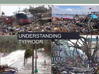
- 42. THE DAMAGING EFFECTS OF TYPHOON
- 43. 1. Heavy rainfall •The typhoon may affect the weather fronts which cause prolonged rains that can saturate the ground. The heavy rainfalls can elevate the water levels in rivers that may overflow, leading to flashflood, landslides, and mudslides as well.
- 44. 2. Strong winds •Strong winds can destroy vehicles, houses, and other buildings. They can blow loose deadly debris which can kill people when those objects fly forward them;
- 45. 3. Storm surges • The forces from the center of the typhoon can cause the rising of the sea level.
- 46. Precautionary measure to lessen the risk brought about by typhoon.