SlideShare a Scribd company logo
1 of 25
PhD project:  Spatial Expansion of the Oil Amazon Frontier and Environmental Conflicts in Ecuador Università degli Studi di Padova Scuola di Dottorato in Scienze Storiche PhD Student: Eugenio Pappalardo Supervisor: Dr. Massimo de Marchi Dipartimento di Geografia “G. Morandini” Indirizzo “Geografia Umana e Geografia Fisica
Research Path ,[object Object],[object Object],[object Object],[object Object],[object Object],[object Object],[object Object],[object Object],[object Object],[object Object],General Objectives
Territorialization processes for substitution of land cover
The Amazon Basin deforestation rate: 2 milioni ha/year  (Myers, 2004) hydrographic basin: 7 million km 2 flow rate: 100-300.000 m 3 /s rainfall: 2000-4000 mm/year
Hydrographic network Amazon Basin: high density network Environmental System
Dep. of Geography, University of Padova -  Eugenio Pappalardo, PhD student   TERRITORIALIZATION PROCESSES IN AMAZON Modernizing territorializations: ,[object Object],[object Object],[object Object],[object Object],[object Object],[object Object],[object Object],[object Object],External actors Internal actors
Geographical framework and study site ,[object Object],[object Object],[object Object],[object Object],[object Object],[object Object],[object Object],[object Object],[object Object],Megadiverse Country  (Myers, 2000) (NASA, World Wind software)
Geographical and territorial framework Area: 256.370 Km2 ,[object Object],[object Object],[object Object],[object Object],[object Object],[object Object],[object Object],[object Object],[object Object],[object Object],Population: 12.5 millions (INAC, 2006)
[object Object],[object Object],[object Object],[object Object],[object Object],study site
Biodiversity conservation and sustainable development Biodiversity Hotspots  (WCMC, Myers, 2000) Classification System:  protected areas categories IUCN CITES, RAMSAR, CONVENTION ON MIGRATORY SPECIES Biosphere Reserve (MAB, UNESCO) Zoning Species dispersion and genetic flux ( Primack ,  2004 ) CONVENTION ON BIOLOGICAL DIVERSITY (Rio, 1992) open system
MAB (UNESCO, 1971): RISERVE DELLA BIOSFERA Integrating the fieldwork research of Natural Sciences with Social Sciences Compatibility models between ecosystem protection and sustainable development project Benefit to local community
 
The Auca Road   ,[object Object],[object Object],One of the 14 bigger deforestation front at global level (Myers, 2000) (Sierra, 2006) AREA DI STUDIO Ecuadorean Amazon Region
MATERIAL AND METHODS Vasca di raccolta idrocarburi (San Carlos, 2010) Pompa d’estrazione, rilievo GPS (Via Pindo, 2010) Sversamento petrolio, (Dayuma, 2009)  MS Channel, QuickBird, 2003)
Espansione spazionale Extractive Industry  (not renewable) driver opening road (deforestation) landcover change Territorial dynamics Overlapping of different territories (different projects) Confrontation of different model of development Water logics vs terrestrial logics (Bertoncin) agrarian colonization (non traditional activity) (colonos, agroindustry) Oil infrastructures landuse change opening road (deforestazione)
use of territory ,[object Object],[object Object],[object Object],[object Object],Footprint of territorial processes of substitution of land cover territorial macro-models Territorialization for “sampling” Territorialization for substitution
Cartographic and bibliography investigation ,[object Object],[object Object],[object Object],[object Object],[object Object],[object Object]
Materiali e metodi ,[object Object],[object Object],[object Object],San Carlos, attività di campo 12/01/2008
ParticipatoryGIS (PGIS) ,[object Object],[object Object],[object Object],[object Object],[object Object],[object Object],[object Object],[object Object],[object Object],(Rambaldi, 2004; Chambers, 2006)
“ Truckble” ,[object Object],[object Object],[object Object],[object Object],FIRST RESULT  –  GIS  ANALYSIS 101 Differenza 381 Tracciati GPS survey 280 Tracciati MAE (2009) 1980 Totale km percorsi Km lineari GIS ANALYSIS
PRIMI RISULTATI  – ANALISI GIS ,[object Object],[object Object],[object Object],Local actor:  colonos Statal actor: GMO, INDA Local actor: wuaorani  Statal actor: MAE (PRAS) indigenous reserve untouchble zone oil production illegal wood extraction
PRIMI RISULTATI  – ANALISI GIS Biosfera Yasuni: conservation and conflicts  ,[object Object],[object Object],[object Object],[object Object],[object Object]
Rilievo GPS MATERIALI E METODI GPS device:   garmin e-trex   error: 4-6 mt su strade (90%) 10-15 mt sotto land cover (10%) Mezzi di trasporto:  ,[object Object],[object Object],[object Object],canoa moto enduro ,[object Object],[object Object],[object Object]
missioni sul campo ,[object Object],[object Object],[object Object],[object Object],[object Object],[object Object],[object Object],2.  ,[object Object],[object Object],[object Object],[object Object],[object Object],[object Object],[object Object],[object Object],[object Object],[object Object],[object Object]
Mercato indigeno, barbecue di  gusanos  (El Coca, settembre 2010) thanks for paying attention

More Related Content

What's hot

OPWALL Project Proposal 2016
OPWALL Project Proposal 2016OPWALL Project Proposal 2016
OPWALL Project Proposal 2016Kevin Schmidt
 
Attività ricerca
Attività ricercaAttività ricerca
Attività ricercaCiro Manzo
 
Structural Trends from Airborne Gravity Data of Delta State, Nigeria
Structural Trends from Airborne Gravity Data of Delta State, NigeriaStructural Trends from Airborne Gravity Data of Delta State, Nigeria
Structural Trends from Airborne Gravity Data of Delta State, NigeriaAssociate Professor in VSB Coimbatore
 
Keith cooper day_3_session_7
Keith cooper day_3_session_7Keith cooper day_3_session_7
Keith cooper day_3_session_7Jennifer Geroni
 
FR2.L10.3: TOWARDS VALIDATION OF SMOS LAND PRODUCTS USING THE SYNERGY BETWEE...
 FR2.L10.3: TOWARDS VALIDATION OF SMOS LAND PRODUCTS USING THE SYNERGY BETWEE... FR2.L10.3: TOWARDS VALIDATION OF SMOS LAND PRODUCTS USING THE SYNERGY BETWEE...
FR2.L10.3: TOWARDS VALIDATION OF SMOS LAND PRODUCTS USING THE SYNERGY BETWEE...grssieee
 
Barriers to Wildlife Migration Coyote Valley
Barriers to Wildlife Migration Coyote ValleyBarriers to Wildlife Migration Coyote Valley
Barriers to Wildlife Migration Coyote ValleyColleen Henn
 
3_Linking quarries
3_Linking quarries3_Linking quarries
3_Linking quarriesRoulling
 
stages of exploration
stages of explorationstages of exploration
stages of explorationNgatcha Bryan
 
2D MASW ANALYSIS FOR GEOTECHNICAL ENGINEERING
2D MASW ANALYSIS FOR GEOTECHNICAL ENGINEERING2D MASW ANALYSIS FOR GEOTECHNICAL ENGINEERING
2D MASW ANALYSIS FOR GEOTECHNICAL ENGINEERINGAli Osman Öncel
 
Abstract for giscon 2013
Abstract for giscon 2013Abstract for giscon 2013
Abstract for giscon 2013Vadde Ramesh
 
Correlated trends on the musculoskeletal anatomy in the base of the skull amo...
Correlated trends on the musculoskeletal anatomy in the base of the skull amo...Correlated trends on the musculoskeletal anatomy in the base of the skull amo...
Correlated trends on the musculoskeletal anatomy in the base of the skull amo...RubnJurezValieri
 
Heritage hetherington lidar_pdf[1]
Heritage hetherington lidar_pdf[1]Heritage hetherington lidar_pdf[1]
Heritage hetherington lidar_pdf[1]llica
 
20160602 Non-Invasive Geophysical Techniques
20160602 Non-Invasive Geophysical Techniques20160602 Non-Invasive Geophysical Techniques
20160602 Non-Invasive Geophysical TechniquesSam Setchell
 
ASM Poster cd jk ma
ASM Poster cd jk maASM Poster cd jk ma
ASM Poster cd jk maJesse Kerr
 
The Ediacaran Dickinsonia is a stem-eumetazoan
The Ediacaran Dickinsonia is a stem-eumetazoanThe Ediacaran Dickinsonia is a stem-eumetazoan
The Ediacaran Dickinsonia is a stem-eumetazoanArshamNejadKourki
 

What's hot (20)

plan_trifinio
plan_trifinioplan_trifinio
plan_trifinio
 
A2100107
A2100107A2100107
A2100107
 
OPWALL Project Proposal 2016
OPWALL Project Proposal 2016OPWALL Project Proposal 2016
OPWALL Project Proposal 2016
 
Attività ricerca
Attività ricercaAttività ricerca
Attività ricerca
 
Ijetr042178
Ijetr042178Ijetr042178
Ijetr042178
 
Structural Trends from Airborne Gravity Data of Delta State, Nigeria
Structural Trends from Airborne Gravity Data of Delta State, NigeriaStructural Trends from Airborne Gravity Data of Delta State, Nigeria
Structural Trends from Airborne Gravity Data of Delta State, Nigeria
 
Keith cooper day_3_session_7
Keith cooper day_3_session_7Keith cooper day_3_session_7
Keith cooper day_3_session_7
 
FR2.L10.3: TOWARDS VALIDATION OF SMOS LAND PRODUCTS USING THE SYNERGY BETWEE...
 FR2.L10.3: TOWARDS VALIDATION OF SMOS LAND PRODUCTS USING THE SYNERGY BETWEE... FR2.L10.3: TOWARDS VALIDATION OF SMOS LAND PRODUCTS USING THE SYNERGY BETWEE...
FR2.L10.3: TOWARDS VALIDATION OF SMOS LAND PRODUCTS USING THE SYNERGY BETWEE...
 
Barriers to Wildlife Migration Coyote Valley
Barriers to Wildlife Migration Coyote ValleyBarriers to Wildlife Migration Coyote Valley
Barriers to Wildlife Migration Coyote Valley
 
3_Linking quarries
3_Linking quarries3_Linking quarries
3_Linking quarries
 
stages of exploration
stages of explorationstages of exploration
stages of exploration
 
2D MASW ANALYSIS FOR GEOTECHNICAL ENGINEERING
2D MASW ANALYSIS FOR GEOTECHNICAL ENGINEERING2D MASW ANALYSIS FOR GEOTECHNICAL ENGINEERING
2D MASW ANALYSIS FOR GEOTECHNICAL ENGINEERING
 
AAS National Conference 2008: Robert Lin
AAS National Conference 2008: Robert LinAAS National Conference 2008: Robert Lin
AAS National Conference 2008: Robert Lin
 
Abstract for giscon 2013
Abstract for giscon 2013Abstract for giscon 2013
Abstract for giscon 2013
 
Correlated trends on the musculoskeletal anatomy in the base of the skull amo...
Correlated trends on the musculoskeletal anatomy in the base of the skull amo...Correlated trends on the musculoskeletal anatomy in the base of the skull amo...
Correlated trends on the musculoskeletal anatomy in the base of the skull amo...
 
Heritage hetherington lidar_pdf[1]
Heritage hetherington lidar_pdf[1]Heritage hetherington lidar_pdf[1]
Heritage hetherington lidar_pdf[1]
 
20160602 Non-Invasive Geophysical Techniques
20160602 Non-Invasive Geophysical Techniques20160602 Non-Invasive Geophysical Techniques
20160602 Non-Invasive Geophysical Techniques
 
Poster sbe dta
Poster sbe dtaPoster sbe dta
Poster sbe dta
 
ASM Poster cd jk ma
ASM Poster cd jk maASM Poster cd jk ma
ASM Poster cd jk ma
 
The Ediacaran Dickinsonia is a stem-eumetazoan
The Ediacaran Dickinsonia is a stem-eumetazoanThe Ediacaran Dickinsonia is a stem-eumetazoan
The Ediacaran Dickinsonia is a stem-eumetazoan
 

Viewers also liked

Part 1. Local Territorial System and Sustainability
Part 1. Local Territorial System and Sustainability Part 1. Local Territorial System and Sustainability
Part 1. Local Territorial System and Sustainability Eugenio Pappalardo
 
Yasuni, conservation, cooperation
Yasuni, conservation, cooperationYasuni, conservation, cooperation
Yasuni, conservation, cooperationEugenio Pappalardo
 
Climate Crisis, RES and Local Development
Climate Crisis, RES and Local DevelopmentClimate Crisis, RES and Local Development
Climate Crisis, RES and Local DevelopmentEugenio Pappalardo
 
Laboratoare Virtuale
Laboratoare VirtualeLaboratoare Virtuale
Laboratoare Virtualehome
 

Viewers also liked (9)

Part 1. Local Territorial System and Sustainability
Part 1. Local Territorial System and Sustainability Part 1. Local Territorial System and Sustainability
Part 1. Local Territorial System and Sustainability
 
Pappalardo Tesis Yasuni
Pappalardo Tesis YasuniPappalardo Tesis Yasuni
Pappalardo Tesis Yasuni
 
Yasuni, conservation, cooperation
Yasuni, conservation, cooperationYasuni, conservation, cooperation
Yasuni, conservation, cooperation
 
Climate Crisis, RES and Local Development
Climate Crisis, RES and Local DevelopmentClimate Crisis, RES and Local Development
Climate Crisis, RES and Local Development
 
Laboratoare Virtuale
Laboratoare VirtualeLaboratoare Virtuale
Laboratoare Virtuale
 
Geografia Applicata
Geografia ApplicataGeografia Applicata
Geografia Applicata
 
Geoapp seminar1
Geoapp seminar1Geoapp seminar1
Geoapp seminar1
 
Open Kollab Vision
Open Kollab VisionOpen Kollab Vision
Open Kollab Vision
 
La foresta planiziale
La foresta planizialeLa foresta planiziale
La foresta planiziale
 

Similar to Part 2 - Case study: the Yasuni Biosphere Reserve

Soil Organic Carbon Map of Mexico
Soil Organic Carbon Map of MexicoSoil Organic Carbon Map of Mexico
Soil Organic Carbon Map of MexicoExternalEvents
 
Exploration of the Ecological Niche of Chacoan Species in Environmental Space
Exploration of the Ecological Niche of Chacoan Species in Environmental SpaceExploration of the Ecological Niche of Chacoan Species in Environmental Space
Exploration of the Ecological Niche of Chacoan Species in Environmental SpaceAlejandro Manuel Ferreiro
 
Geoinformation monitoring of regenerative successions at the territory of Kho...
Geoinformation monitoring of regenerative successions at the territory of Kho...Geoinformation monitoring of regenerative successions at the territory of Kho...
Geoinformation monitoring of regenerative successions at the territory of Kho...Liashenko Dmytro
 
RIVER NETWORKS AS ECOLOGICAL CORRIDORS FOR SPECIES POPULATIONS AND WATER-BORN...
RIVER NETWORKS AS ECOLOGICAL CORRIDORS FOR SPECIES POPULATIONS AND WATER-BORN...RIVER NETWORKS AS ECOLOGICAL CORRIDORS FOR SPECIES POPULATIONS AND WATER-BORN...
RIVER NETWORKS AS ECOLOGICAL CORRIDORS FOR SPECIES POPULATIONS AND WATER-BORN...Riccardo Rigon
 
Team Mangrove Pre-proposal Presentation
Team Mangrove Pre-proposal PresentationTeam Mangrove Pre-proposal Presentation
Team Mangrove Pre-proposal PresentationLaura Fidalgo De Souza
 
Elmes_Yarleque_Mapping_licit_illicit_gold_mining_in_madre_de_dios_Peru
Elmes_Yarleque_Mapping_licit_illicit_gold_mining_in_madre_de_dios_PeruElmes_Yarleque_Mapping_licit_illicit_gold_mining_in_madre_de_dios_Peru
Elmes_Yarleque_Mapping_licit_illicit_gold_mining_in_madre_de_dios_PeruGabriel Yarlequé Ipanaqué
 
Wildfire in Valencia
Wildfire in ValenciaWildfire in Valencia
Wildfire in ValenciaJuan Mena
 
Diffuse reflectance spectroscopy to estimate soil attributes of Brazilian wet...
Diffuse reflectance spectroscopy to estimate soil attributes of Brazilian wet...Diffuse reflectance spectroscopy to estimate soil attributes of Brazilian wet...
Diffuse reflectance spectroscopy to estimate soil attributes of Brazilian wet...Agriculture Journal IJOEAR
 
Human wildlife conflict in banke national park,nepal
Human wildlife conflict in  banke national park,nepalHuman wildlife conflict in  banke national park,nepal
Human wildlife conflict in banke national park,nepalkpkc1633
 
Assessing Desertification In Sub-Saharan Peri-Urban Areas Case Study Applica...
Assessing Desertification In Sub-Saharan Peri-Urban Areas  Case Study Applica...Assessing Desertification In Sub-Saharan Peri-Urban Areas  Case Study Applica...
Assessing Desertification In Sub-Saharan Peri-Urban Areas Case Study Applica...Joe Andelija
 
Application of remote sensing in forest ecosystem
Application of remote sensing in forest ecosystemApplication of remote sensing in forest ecosystem
Application of remote sensing in forest ecosystemaliya nasir
 
[International agrophysics] ground penetrating radar for underground sensing ...
[International agrophysics] ground penetrating radar for underground sensing ...[International agrophysics] ground penetrating radar for underground sensing ...
[International agrophysics] ground penetrating radar for underground sensing ...Minal Ghugal
 
MORPHOMETRIC ANALYSIS OF THE SUMANPA RIVER CATCHMENTAT MAMPONG-ASHANTI IN GHANA
MORPHOMETRIC ANALYSIS OF THE SUMANPA RIVER CATCHMENTAT MAMPONG-ASHANTI IN GHANAMORPHOMETRIC ANALYSIS OF THE SUMANPA RIVER CATCHMENTAT MAMPONG-ASHANTI IN GHANA
MORPHOMETRIC ANALYSIS OF THE SUMANPA RIVER CATCHMENTAT MAMPONG-ASHANTI IN GHANAEric Takyi Atakora , Ph.D (candidate)
 
Digitisation of the harvestmen of the BOS Arthropod Collection
Digitisation of the harvestmen of the BOS Arthropod CollectionDigitisation of the harvestmen of the BOS Arthropod Collection
Digitisation of the harvestmen of the BOS Arthropod CollectionAntonio Torralba Burrial
 
From global to regional scale: Remote sensing-based concepts and methods for ...
From global to regional scale: Remote sensing-based concepts and methods for ...From global to regional scale: Remote sensing-based concepts and methods for ...
From global to regional scale: Remote sensing-based concepts and methods for ...Repository Ipb
 
Understanding land use influence to coastal ecosystems in the Rio Grande de M...
Understanding land use influence to coastal ecosystems in the Rio Grande de M...Understanding land use influence to coastal ecosystems in the Rio Grande de M...
Understanding land use influence to coastal ecosystems in the Rio Grande de M...Loretta Roberson
 
Risks of Cryogenic Landslide Hazards and Their Impact on Ecosystems in Cold E...
Risks of Cryogenic Landslide Hazards and Their Impact on Ecosystems in Cold E...Risks of Cryogenic Landslide Hazards and Their Impact on Ecosystems in Cold E...
Risks of Cryogenic Landslide Hazards and Their Impact on Ecosystems in Cold E...Universität Salzburg
 
GFW Partner Meeting 2017 - Parallel Discussions 3: Monitoring Beyond Forests
GFW Partner Meeting 2017 - Parallel Discussions 3: Monitoring Beyond ForestsGFW Partner Meeting 2017 - Parallel Discussions 3: Monitoring Beyond Forests
GFW Partner Meeting 2017 - Parallel Discussions 3: Monitoring Beyond ForestsWorld Resources Institute (WRI)
 
A knowledge-based model for identifying and mapping tropical wetlands and pea...
A knowledge-based model for identifying and mapping tropical wetlands and pea...A knowledge-based model for identifying and mapping tropical wetlands and pea...
A knowledge-based model for identifying and mapping tropical wetlands and pea...ExternalEvents
 

Similar to Part 2 - Case study: the Yasuni Biosphere Reserve (20)

Soil Organic Carbon Map of Mexico
Soil Organic Carbon Map of MexicoSoil Organic Carbon Map of Mexico
Soil Organic Carbon Map of Mexico
 
Exploration of the Ecological Niche of Chacoan Species in Environmental Space
Exploration of the Ecological Niche of Chacoan Species in Environmental SpaceExploration of the Ecological Niche of Chacoan Species in Environmental Space
Exploration of the Ecological Niche of Chacoan Species in Environmental Space
 
DSM_46CNCS.pptx.pdf
DSM_46CNCS.pptx.pdfDSM_46CNCS.pptx.pdf
DSM_46CNCS.pptx.pdf
 
Geoinformation monitoring of regenerative successions at the territory of Kho...
Geoinformation monitoring of regenerative successions at the territory of Kho...Geoinformation monitoring of regenerative successions at the territory of Kho...
Geoinformation monitoring of regenerative successions at the territory of Kho...
 
RIVER NETWORKS AS ECOLOGICAL CORRIDORS FOR SPECIES POPULATIONS AND WATER-BORN...
RIVER NETWORKS AS ECOLOGICAL CORRIDORS FOR SPECIES POPULATIONS AND WATER-BORN...RIVER NETWORKS AS ECOLOGICAL CORRIDORS FOR SPECIES POPULATIONS AND WATER-BORN...
RIVER NETWORKS AS ECOLOGICAL CORRIDORS FOR SPECIES POPULATIONS AND WATER-BORN...
 
Team Mangrove Pre-proposal Presentation
Team Mangrove Pre-proposal PresentationTeam Mangrove Pre-proposal Presentation
Team Mangrove Pre-proposal Presentation
 
Elmes_Yarleque_Mapping_licit_illicit_gold_mining_in_madre_de_dios_Peru
Elmes_Yarleque_Mapping_licit_illicit_gold_mining_in_madre_de_dios_PeruElmes_Yarleque_Mapping_licit_illicit_gold_mining_in_madre_de_dios_Peru
Elmes_Yarleque_Mapping_licit_illicit_gold_mining_in_madre_de_dios_Peru
 
Wildfire in Valencia
Wildfire in ValenciaWildfire in Valencia
Wildfire in Valencia
 
Diffuse reflectance spectroscopy to estimate soil attributes of Brazilian wet...
Diffuse reflectance spectroscopy to estimate soil attributes of Brazilian wet...Diffuse reflectance spectroscopy to estimate soil attributes of Brazilian wet...
Diffuse reflectance spectroscopy to estimate soil attributes of Brazilian wet...
 
Human wildlife conflict in banke national park,nepal
Human wildlife conflict in  banke national park,nepalHuman wildlife conflict in  banke national park,nepal
Human wildlife conflict in banke national park,nepal
 
Assessing Desertification In Sub-Saharan Peri-Urban Areas Case Study Applica...
Assessing Desertification In Sub-Saharan Peri-Urban Areas  Case Study Applica...Assessing Desertification In Sub-Saharan Peri-Urban Areas  Case Study Applica...
Assessing Desertification In Sub-Saharan Peri-Urban Areas Case Study Applica...
 
Application of remote sensing in forest ecosystem
Application of remote sensing in forest ecosystemApplication of remote sensing in forest ecosystem
Application of remote sensing in forest ecosystem
 
[International agrophysics] ground penetrating radar for underground sensing ...
[International agrophysics] ground penetrating radar for underground sensing ...[International agrophysics] ground penetrating radar for underground sensing ...
[International agrophysics] ground penetrating radar for underground sensing ...
 
MORPHOMETRIC ANALYSIS OF THE SUMANPA RIVER CATCHMENTAT MAMPONG-ASHANTI IN GHANA
MORPHOMETRIC ANALYSIS OF THE SUMANPA RIVER CATCHMENTAT MAMPONG-ASHANTI IN GHANAMORPHOMETRIC ANALYSIS OF THE SUMANPA RIVER CATCHMENTAT MAMPONG-ASHANTI IN GHANA
MORPHOMETRIC ANALYSIS OF THE SUMANPA RIVER CATCHMENTAT MAMPONG-ASHANTI IN GHANA
 
Digitisation of the harvestmen of the BOS Arthropod Collection
Digitisation of the harvestmen of the BOS Arthropod CollectionDigitisation of the harvestmen of the BOS Arthropod Collection
Digitisation of the harvestmen of the BOS Arthropod Collection
 
From global to regional scale: Remote sensing-based concepts and methods for ...
From global to regional scale: Remote sensing-based concepts and methods for ...From global to regional scale: Remote sensing-based concepts and methods for ...
From global to regional scale: Remote sensing-based concepts and methods for ...
 
Understanding land use influence to coastal ecosystems in the Rio Grande de M...
Understanding land use influence to coastal ecosystems in the Rio Grande de M...Understanding land use influence to coastal ecosystems in the Rio Grande de M...
Understanding land use influence to coastal ecosystems in the Rio Grande de M...
 
Risks of Cryogenic Landslide Hazards and Their Impact on Ecosystems in Cold E...
Risks of Cryogenic Landslide Hazards and Their Impact on Ecosystems in Cold E...Risks of Cryogenic Landslide Hazards and Their Impact on Ecosystems in Cold E...
Risks of Cryogenic Landslide Hazards and Their Impact on Ecosystems in Cold E...
 
GFW Partner Meeting 2017 - Parallel Discussions 3: Monitoring Beyond Forests
GFW Partner Meeting 2017 - Parallel Discussions 3: Monitoring Beyond ForestsGFW Partner Meeting 2017 - Parallel Discussions 3: Monitoring Beyond Forests
GFW Partner Meeting 2017 - Parallel Discussions 3: Monitoring Beyond Forests
 
A knowledge-based model for identifying and mapping tropical wetlands and pea...
A knowledge-based model for identifying and mapping tropical wetlands and pea...A knowledge-based model for identifying and mapping tropical wetlands and pea...
A knowledge-based model for identifying and mapping tropical wetlands and pea...
 

Part 2 - Case study: the Yasuni Biosphere Reserve

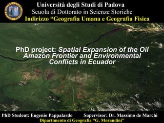
  • 1. PhD project: Spatial Expansion of the Oil Amazon Frontier and Environmental Conflicts in Ecuador Università degli Studi di Padova Scuola di Dottorato in Scienze Storiche PhD Student: Eugenio Pappalardo Supervisor: Dr. Massimo de Marchi Dipartimento di Geografia “G. Morandini” Indirizzo “Geografia Umana e Geografia Fisica
  • 2.
  • 3. Territorialization processes for substitution of land cover
  • 4. The Amazon Basin deforestation rate: 2 milioni ha/year (Myers, 2004) hydrographic basin: 7 million km 2 flow rate: 100-300.000 m 3 /s rainfall: 2000-4000 mm/year
  • 5. Hydrographic network Amazon Basin: high density network Environmental System
  • 6.
  • 7.
  • 8.
  • 9.
  • 10. Biodiversity conservation and sustainable development Biodiversity Hotspots (WCMC, Myers, 2000) Classification System: protected areas categories IUCN CITES, RAMSAR, CONVENTION ON MIGRATORY SPECIES Biosphere Reserve (MAB, UNESCO) Zoning Species dispersion and genetic flux ( Primack , 2004 ) CONVENTION ON BIOLOGICAL DIVERSITY (Rio, 1992) open system
  • 11. MAB (UNESCO, 1971): RISERVE DELLA BIOSFERA Integrating the fieldwork research of Natural Sciences with Social Sciences Compatibility models between ecosystem protection and sustainable development project Benefit to local community
  • 12.  
  • 13.
  • 14. MATERIAL AND METHODS Vasca di raccolta idrocarburi (San Carlos, 2010) Pompa d’estrazione, rilievo GPS (Via Pindo, 2010) Sversamento petrolio, (Dayuma, 2009) MS Channel, QuickBird, 2003)
  • 15. Espansione spazionale Extractive Industry (not renewable) driver opening road (deforestation) landcover change Territorial dynamics Overlapping of different territories (different projects) Confrontation of different model of development Water logics vs terrestrial logics (Bertoncin) agrarian colonization (non traditional activity) (colonos, agroindustry) Oil infrastructures landuse change opening road (deforestazione)
  • 16.
  • 17.
  • 18.
  • 19.
  • 20.
  • 21.
  • 22.
  • 23.
  • 24.
  • 25. Mercato indigeno, barbecue di gusanos (El Coca, settembre 2010) thanks for paying attention