SlideShare una empresa de Scribd logo
1 de 54
Descargar para leer sin conexión
United States General Accounting Office

GAO          Report to the Chairman, Subcommittee
             on Housing and Community
             Opportunity, Committee on Financial
             Services, House of Representatives

March 2004
             FLOOD MAP
             MODERNIZATION

             Program Strategy
             Shows Promise, but
             Challenges Remain


GAO-04-417
March 2004


                                                FLOOD MAP MODERNIZATION

                                                Program Strategy Shows Promise, but
                                                Challenges Remain
Highlights of GAO-04-417, a report to the
Chairman, Subcommittee on Housing and
Community Opportunity, Committee on
Financial Services, House of
Representatives


Flood maps identify areas at                    Through its map modernization program, FEMA intends to use advanced
greatest risk of flooding and                   technologies to produce more accurate and accessible digital flood maps
provide the foundation for the                  available on the Internet. These maps are expected to improve community
National Flood Insurance Program                efforts to reduce the impact of floods, increase property owners’ use of flood
(NFIP) managed by the Federal
                                                insurance, and improve community, state and federal efforts to reduce the
Emergency Management Agency
                                                risks of other natural and man-made hazards.
(FEMA). The maps are used by
(1) communities to establish
                                                In developing digital flood maps, FEMA plans to incorporate data that are of
minimum building standards
                                                a level of specificity and accuracy commensurate with communities’ relative
designed to reduce the impact of
                                                flood risk. According to FEMA, there is a direct relationship between the
flooding, (2) FEMA to set insurance
                                                types, quantity, and detail of the data and analysis used to develop maps and
rates, and (3) lenders to identify
property owners who are required                the costs of obtaining and analyzing those data. Although FEMA ranked the
to purchase flood insurance. Nearly             nation’s 3,146 counties from highest to lowest risk, it has not yet established
70 percent of all flood maps are                data standards that describe the appropriate level of detail, accuracy, and
more than 10 years old, according               analysis required to develop digital maps based on risk level. Without such
to FEMA. In an effort to update its
                                                standards, FEMA cannot ensure that it uses the same level of data collection
flood maps, FEMA is implementing
                                                and analysis for all communities in the same risk category. Such standards
a $1 billion, 5-year map
                                                can also help FEMA to target its map modernization resources more
modernization program. GAO was
                                                efficiently by matching the level of data collection and analysis with the level
asked to review the progress of
                                                of flood risk.
FEMA’s map modernization
program.
                                                FEMA has developed partnerships with states and local entities that have
                                                begun mapping activities and has a strategy on how to best work with these
                                                entities. However, the overall effectiveness of FEMA’s future partnering
To help ensure that FEMA’s map
                                                efforts is uncertain because FEMA has not yet developed a clear strategy for
modernization program achieves
                                                partnering with communities with less resources and little or no experience
its intended benefits, GAO is
                                                in flood mapping. By developing such a strategy, FEMA will be better able to
making several recommendations.
                                                identify and use the most effective approaches to engage all of its partners in
FEMA should address differences
                                                map modernization.
among the communities for which
flood maps are being developed—                 Comparison of Old Paper and New Digital Map Sections in North Carolina
whether those differences arise
from different levels of flood risk
or different levels of capacity and
resources to assist with flood
mapping.


www.gao.gov/cgi-bin/getrpt?GAO-04-417.

To view the full product, including the scope
and methodology, click on the link above.
For more information, contact William O.          Paper flood map section                                    Digital flood map section
Jenkins, 202-512-8777, jenkinswo@gao.gov.
                                                Source: North Carolina Department of Emergency Management.
Contents


Letter                                                                                  1
               Results in Brief                                                         3
               Background                                                               5
               Map Modernization Intends to Use Advanced Technologies to
                 Produce More Accurate and Accessible Digital Flood Maps                9
               FEMA Expects Map Modernization to Increase the Likelihood
                 Maps Will Be Used for Risk Management                                16
               FEMA’s Strategy for Map Modernization Shows Promise, but
                 Challenges Remain                                                    29
               Conclusions                                                            40
               Recommendations                                                        41
               Agency Comments                                                        42

Appendix I     Objectives, Scope, and Methodology                                      44


Appendix II    Users of Flood Maps                                                     47


Appendix III   GAO Contacts and Staff Acknowledgments                                  49
               GAO Contacts                                                           49
               Staff Acknowledgments                                                  49


Table
               Table 1: FEMA’s Objectives for Map Modernization and Our
                        Observations on the Objectives and Challenges                 30


Figures
               Figure 1: Age of the Nation’s Current Flood Map Inventory               9
               Figure 2: Key GIS Layers or Themes for Digital Flood Maps              11
               Figure 3: Comparison of Original and Updated Floodplain for Plum
                        Creek in Douglas County, Colorado                             13
               Figure 4: Use of LIDAR Technology                                      15
               Figure 5: Comparison of Old Paper and New Digital Map Sections
                        in North Carolina                                             16
               Figure 6: Expected Benefits of Map Modernization                       18


               Page i                                  GAO-04-417 Flood Map Modernization
Figure 7: Comparison of FEMA and Sarasota County Floodplain
         after Remapping                                                                  20
Figure 8: Impact of Capital Improvement Project on Floodplain in
         Sarasota County                                                                  22
Figure 9: Expanded Floodplain Boundary for Regulating New
         Construction in Mecklenburg County, North Carolina                               23
Figure 10: Flooding in Greenville, North Carolina, during Hurricane
         Floyd                                                                            27
Figure 11: Example of Spill Response Model in Harris County,
         Texas                                                                            28
Figure 12: Comparison of Cumulative FEMA Funding for Mapping
         Data with the Total Cumulative Dollar Value of Mapping
         Data Produced through CTP Program                                                36
Figure 13: Status of Remapping in North Carolina                                          38


Abbreviations

CTP               Cooperating Technical Partner
DHS               Department of Homeland Security
FEMA              Federal Emergency Management Agency
GIS               Geographic Information Systems
LIDAR             Light Detection and Ranging
NFIP              National Flood Insurance Program


This is a work of the U.S. government and is not subject to copyright protection in the
United States. It may be reproduced and distributed in its entirety without further
permission from GAO. However, because this work may contain copyrighted images or
other material, permission from the copyright holder may be necessary if you wish to
reproduce this material separately.


Page ii                                            GAO-04-417 Flood Map Modernization
United States General Accounting Office
Washington, DC 20548


                                   March 31, 2004

                                   The Honorable Robert W. Ney
                                   Chairman
                                   Subcommittee on Housing and Community Opportunity
                                   Committee on Financial Services
                                   House of Representatives

                                   Dear Mr. Chairman:

                                   Floods inflict more damage and economic losses upon the United States
                                   than any other natural disaster. During the 10 years from fiscal year 1992
                                   through fiscal year 2001, flooding caused over 900 deaths and resulted in
                                   approximately $55 billion in damages.1 Since its inception 36 years ago, the
                                   National Flood Insurance Program (NFIP) has combined the development
                                   of flood maps to identify the areas at greatest risk of flooding with
                                   mitigation2 efforts to reduce or eliminate flood risks to people and
                                   property and the availability of insurance that property owners can
                                   purchase to protect themselves from flood losses. To date, the flood
                                   insurance program has paid about $12 billion in insurance claims,
                                   primarily from policyholder premiums, that otherwise would have been
                                   paid, at least in part, from taxpayer-funded disaster relief.

                                   The Federal Emergency Management Agency (FEMA) is responsible for
                                   managing the NFIP, including the development of flood maps.3 Accurate
                                   flood maps that identify the areas at greatest risk of flooding are the
                                   foundation of the NFIP. The maps are principally used by (1) the


                                   1
                                    Data are from the U.S. Army Corps of Engineers in cooperation with the National Weather
                                   Service.
                                   2
                                    Mitigation is defined by the Federal Emergency Management Agency as sustained action
                                   that reduces or eliminates long-term risk to people and property from hazards and their
                                   effects.
                                   3
                                    Prior to March 2003, FEMA was an independent agency whose Federal Insurance and
                                   Mitigation Administration was responsible for managing the flood insurance program. The
                                   Homeland Security Act of 2002, P.L. 107-296 (Nov. 25, 2002), transferred FEMA and all its
                                   responsibilities to the Emergency Preparedness and Response Directorate within the new
                                   Department of Homeland Security. This transfer was effective March 1, 2003. Currently, the
                                   Mitigation Division within FEMA is responsible for the flood insurance program, including
                                   flood map modernization.


                                   Page 1                                             GAO-04-417 Flood Map Modernization
approximately 20,000 communities participating in the NFIP to adopt and
enforce the program’s minimum building standards for new construction
within the maps’ identified floodplains, (2) FEMA to develop accurate
flood insurance policy rates based on flood risk, and (3) federally
regulated mortgage lenders to identify those property owners who are
statutorily required to purchase federal flood insurance. Under the
National Flood Insurance Act of 1968, as amended,4 property owners
whose properties are within the designated floodplain and have a
mortgage from a federally regulated financial institution are required to
purchase federal flood insurance. Flood maps can become outdated for a
variety of reasons, such as erosion or community growth and development
that can affect the drainage patterns of rainwater. Thus, flood maps must
be periodically updated to assess and map changes in the boundaries of
floodplains that result from community growth, development, erosion, and
other factors that affect the boundaries of areas at risk for flooding.
According to FEMA, limited funding for flood mapping has resulted in a
backlog of outdated maps. FEMA estimates that as of March 2004 nearly
70 percent of the nation’s flood maps were more than 10 years old and
reflected outdated data that could affect the ability to accurately identify
current flood hazard areas.

With congressional support and funding, FEMA has embarked on a
$1 billion, 5-year effort to update the nation’s flood maps. Recognizing that
FEMA is currently in the early stages of its map modernization effort, our
objectives for this review were to answer the following questions: (1) How
is map modernization intended to improve the accuracy and accessibility
of the nation’s flood maps? (2) What are the expected benefits of more
accurate and accessible flood maps? (3) To what extent does FEMA’s
strategy for managing the map modernization program support the
achievement of these benefits and what, if any, limitations could affect the
implementation of the strategy?

To answer these questions, we analyzed available information from FEMA
on the program’s purpose, objectives, and status and met with agency
officials in headquarters and in the regional offices to discuss the
program’s progress. We also conducted site visits to states and
communities that have already begun to modernize their flood maps and
interviewed industry organizations such as the Association of State Flood
Plain Managers, the National Association of Flood and Stormwater


4
 See 42 U.S.C. 4001 et seq.


Page 2                                     GAO-04-417 Flood Map Modernization
Management Agencies, and the National Emergency Management
                   Association. We conducted our work from April 2003 to March 2004 in
                   accordance with generally accepted government auditing standards. See
                   appendix I for more details on our scope and methodology.

                   Through map modernization, FEMA intends to produce more accurate and
Results in Brief   accessible flood maps by using advanced technology to gather accurate
                   data and make the flood maps, and the digital information on which they
                   are based, available on the Internet. For example, displaying map data in
                   digital Geographic Information Systems format permits consistent,
                   accurate display and ready electronic retrieval of a variety of map features,
                   including elevation data and the location of key infrastructure, such as
                   utilities. According to FEMA, nearly 70 percent of the nation’s
                   approximately 92,222 flood maps are more than 10 years old, and many of
                   these maps no longer reflect current flood hazard risks because of such
                   changes as erosion and development that can alter drainage patterns and
                   thus the areas at highest risk of flooding. Moreover, since many flood
                   maps were created or last updated, there have been improvements in the
                   techniques for assessing and displaying flood risks.

                   FEMA expects that by producing more accurate and accessible digital
                   flood maps through map modernization, the nation will benefit in three
                   ways. First, communities can use more accurate digital maps to reduce
                   flood risk within floodplains by more effectively regulating development
                   through zoning and building standards. Second, accurate digital maps
                   available on the Internet will facilitate the identification of property
                   owners who are statutorily required to obtain or who would be best served
                   by obtaining flood insurance. Third, accurate and precise data will help
                   national, state, and local officials to accurately locate infrastructure and
                   transportation systems (e.g., power plants, sewage treatment plants,
                   railroads, bridges, and ports) to help mitigate and manage risk for multiple
                   hazards, both natural and man-made.

                   FEMA’s strategy for managing map modernization is designed to support
                   the expected program benefits, but FEMA’s approach to implementing the
                   strategy raises several concerns that could hamper the agency’s efforts.
                   FEMA’s implementation approach is based on four objectives:
                   (1) establish and maintain a premier data system, (2) expand outreach
                   and better inform the user community, (3) establish and maintain effective
                   partnerships, and (4) achieve effective program management.

                       Establish and maintain a premier data system: Although FEMA’s
                   •
                       efforts to establish a new data system could result in more accurate


                   Page 3                                     GAO-04-417 Flood Map Modernization
flood maps and make it easier to access and use the revised flood
    maps, FEMA has not yet established clear standards for the types,
    quantity, and specificity of data collection and analysis associated with
    different levels of flood risk. FEMA has ranked the nation’s
    3,146 counties from highest to lowest flood risk. According to FEMA,
    communities at the highest risk of flooding require the most extensive,
    detailed data and analysis, but the same level of data collection and
    analysis may not be necessary to create accurate, useful maps for
    communities with lower flood risks. Defining the level of data
    collection and analysis for different levels of risk is important because
    obtaining and analyzing flood map data is time-consuming and
    expensive, and the more detailed and specific the data, generally the
    greater the effort and costs required to obtain it. By identifying the
    types, quantity, and specificity of the data and analysis needed for
    communities based on their risk, FEMA can better ensure that data
    collection and analysis is consistent for all communities with similar
    risk and that it is using its resources efficiently while producing maps
    that are accurate and useful for communities at different levels of flood
    risk. FEMA acknowledges the need to develop such standards, but has
    not yet developed draft standards or included this task into its map
    modernization implementation plan.

    Expand outreach and better inform the user community: FEMA’s
•
    planned expanded outreach efforts are intended to increase public
    awareness and obtain community acceptance of the updated flood
    maps because the updated information could potentially identify
    changes in floodplain boundaries and, therefore, affect property
    owners, including whether or not their property’s location may require
    them to purchase federal flood insurance. FEMA’s intended outcome
    for these outreach efforts is to reduce community vulnerability to
    natural and man-made hazards and increase participation in the flood
    insurance program. Because FEMA does not have the authority to
    require that affected property owners take steps to mitigate their
    properties against flood risks or to ensure that owners whose
    properties are in the floodplain purchase flood insurance, effective
    outreach is essential to ultimately achieve these benefits.

    Establish and maintain effective partnerships: FEMA’s objective
•
    for building and maintaining mutually beneficial partnerships is
    designed to facilitate and support the efficient production and effective
    use of maps. FEMA recognizes that local, state, and federal agencies,
    that have been working on mapping activities for years, have the
    resources and potential to positively affect the quality and quantity of
    the data collected and improve the way these data are used. In


Page 4                                      GAO-04-417 Flood Map Modernization
addition, these partnerships can enable FEMA to leverage its resources
                 and reduce the federal costs of map modernization. FEMA has
                 developed a strategy for partnering with these agencies to encourage
                 greater involvement in map modernization, including the contribution
                 of resources. However, the overall effectiveness of the agency’s future
                 partnering efforts is uncertain because FEMA has not yet developed a
                 clear strategy for partnering with communities that have few resources,
                 limited mapping capability, and little history of flood mapping
                 activities.

                 Achieve effective program management: In March 2004, FEMA
             •
                 awarded a performance-based contract to a single contractor to
                 oversee map modernization that includes performance measures to
                 gauge the success of its efforts. Through a staffing analysis, FEMA has
                 determined that it needs 75 staff with specific, identified skills to
                 effectively monitor and manage the contract and overall map
                 modernization program. As of March 2004, FEMA had hired 1 of the
                 75 staff, had developed plans to hire or transfer 43 others, but had not
                 yet determine how it would acquire the remaining 31 positions. FEMA
                 has not clearly defined performance measures related to whether (1)
                 the revised maps meet any established standards for accuracy and
                 (2) outreach efforts have been successful in increasing the community
                 and individual awareness and use of flood maps.

             To help ensure that FEMA’s map modernization program achieves its
             intended benefits, we make recommendations to the Secretary of
             Homeland Security to direct the Undersecretary of Emergency
             Preparedness and Response to address data and analysis standards,
             partnering with state and local governments, and program management.
             We provided a copy of our draft report to the Department of Homeland
             Security (DHS) for comment. In its oral comments, DHS generally
             concurred with the report’s findings and recommendations and provided
             technical comments that we incorporated where appropriate.


             FEMA is the primary federal agency responsible for assisting state and
Background   local governments, private entities, and individuals to prepare for,
             mitigate, respond to, and recover from natural disasters, including floods.
             FEMA’s NFIP has served as a key component of the agency’s efforts to
             minimize or mitigate the damage and financial impact of floods on the
             public, as well as to limit federal expenditures needed after floods occur.


             Page 5                                      GAO-04-417 Flood Map Modernization
In 1968, to address the increasing amount of flood damage, the lack of
readily available insurance for property owners, and the cost to the
taxpayer for flood-related disaster relief, the National Flood Insurance Act
of 1968,5 created the NFIP. Since its inception, the program has sought to
minimize flood-related property losses by making flood insurance
available on reasonable terms and encouraging its purchase by people
who need flood insurance protection—particularly those living in the
areas at highest risk of flooding known as special flood hazard areas. The
program identifies and maps flood-prone areas in the country, makes flood
insurance available to property owners in the nearly 20,000 communities
that currently participate in the program,6 and requires floodplain
management efforts to mitigate flood hazards on the part of participating
communities.

FEMA’s flood maps are one of the basic, essential tools for flood hazard
mitigation in the United States. FEMA estimates that the maps are used an
estimated 30 million times annually in the private and public sectors.
FEMA uses the maps to identify the floodplain boundaries in which flood
insurance is required and to set flood insurance rates. Mortgage lending
institutions use the maps to determine who is required to purchase flood
insurance and ensure that flood insurance is purchased and maintained for
these properties. Community planning officials, land developers, and
engineers use the maps for designing new buildings and infrastructure to
be safe from flooding. See appendix II for more information on the various
stakeholders that use and rely upon flood maps.

Flood maps provide the basis for establishing floodplain building
standards that participating communities must adopt and enforce as part
of the program. For a community to participate in the program, any
structures built within special flood hazard areas—also known as 100-year
floodplains7—that have a 1 percent or greater chance of experiencing
flooding in any given year must be built according to the program’s
building standards whose purpose is to minimize flood losses. A key
component of the program’s building standards that must be followed by
participating communities is a requirement that the lowest floor of the


5
 P.L. 90-448, (Aug. 1, 1968).
6
 Also included are Puerto Rico and the Virgin Islands.
7
 For clarity and ease of discussion throughout the report, we use the term “floodplain” in
all discussions where we address the special flood hazard area or 100-year floodplain.


Page 6                                              GAO-04-417 Flood Map Modernization
structure be elevated to or above the base flood level—the elevation at
which there is a 1 percent chance of flooding in a given year. The
administration has estimated that local governments’ compliance with the
program’s standards for new construction is saving over $1 billion
annually in flood damage avoided.

Flood maps also provide the basis for setting insurance rates and
identifying properties whose owners are required to purchase flood
insurance. When the NFIP was created, the purchase of flood insurance
was voluntary. To increase the impact of the program, however, Congress
amended the original law in 1973 to require the purchase of flood
insurance in certain circumstances. Flood insurance is required for
structures in special flood hazard areas of communities participating in the
program if (1) any federal loans or grants were used to acquire or build the
structures or (2) the structures have outstanding mortgage loans made by
lending institutions that are regulated by the federal government. Owners
of properties without mortgages or properties with mortgages held by
unregulated lenders were not, and still are not, required to purchase flood
insurance, even if the properties are in special flood hazard areas.

Federal regulations require that FEMA communicate potential changes in
flood risk to the public when it decides to initiate a flood mapping study
and when it is ready to release preliminary maps. At the beginning of the
mapping process, FEMA is required to notify community stakeholders.8
When FEMA is ready to release preliminary maps, the agency must publish
the proposed base flood elevations in the Federal Register for public
comment and notify the community of the results of the study.9 When the
final map is approved and implemented, FEMA publishes another Federal
Register notice.10


8
 FEMA is required to contact community stakeholders, such as the state coordinating
agency and other appropriate community officials, to discuss the scope and methodology
for the proposed flood map study. 44 C.F.R. sec. 66.5.
9
 FEMA is required to publish the proposed flood elevations in a prominent local newspaper
at least twice during the 10-day period following the notification of the community chief
executive officer. Property owners have 90 days from the second newspaper publication to
appeal the proposed flood elevations. 44 C.F.R. secs. 67.4, 67.5.
10
 Final flood elevations must be published in the Federal Register and copies sent to the
community chief executive officer, all individual appellants, and the state-coordinating
agency. 44 C.F.R. 67.11.


Page 7                                              GAO-04-417 Flood Map Modernization
In the early 1990s, some of the data and information FEMA collected to
develop flood maps were becoming available in digital format. In 1994, the
President issued Executive Order 12906, which mandated that standards
for digital geographic data be applied uniformly across the federal
government. Anticipating that electronic data would soon become the
standard vehicle for information delivery and in an attempt to make flood
map production more cost-effective and efficient, FEMA developed a
prototype for a digital flood map.

In 1997, FEMA developed its initial flood map modernization plan that
outlined the steps necessary to update the nation’s flood maps to digital
format and streamline FEMA’s operations in raising public awareness of
the importance of the maps and responding to requests to revise them.
This initial plan and subsequent updates to the plan reflected the
recommendations of the Technical Mapping Advisory Council created by
Congress and active from 1995-2000. The council provided a number of
recommendations which were aimed at making the digital flood map the
future method for assessing flood hazard risk and setting federal insurance
rates. Recognizing the importance of updating the nation’s flood maps,
Congress appropriated additional funds in fiscal years 2000-2002. FEMA
used these funds to launch its map modernization program through such
activities as developing new flood mapping standards and procedures,
expanding the Cooperating Technical Partner (CTP) program that
recognizes and encourages state and local participation in flood hazard
data development and maintenance and developing some digital flood
maps. In fiscal year 2003, Congress appropriated $150 million, allowing
FEMA to initiate a full-scale update of the nation’s flood maps called the
Multi-Hazard Flood Map Modernization Program,11 an effort FEMA expects
to take about 5 years and cost about $1 billion. In fiscal year 2004,
Congress appropriated an additional $200 million for map modernization,
and the administration has requested an additional $200 million for fiscal
year 2005 to continue the program. FEMA has established four primary
objectives for implementing map modernization: (1) establish and
maintain a premier data collection and delivery system, (2) expand
outreach and better inform the user community, (3) build and maintain
mutually beneficial partnerships, and (4) achieve effective program
management. In March 2004, FEMA awarded a performance-based


11
 For clarity and ease of discussion throughout the report, we use the term “map
modernization” in all discussions where we address the Multi-Hazard Flood Map
Modernization Program.


Page 8                                             GAO-04-417 Flood Map Modernization
contract for overseeing map modernization that includes contractor
                     performance measures for each of these objectives.


                     Through map modernization, FEMA intends to produce more accurate and
Map Modernization    accessible flood maps by using advanced technology to gather accurate
Intends to Use       data and make the resulting information available on the Internet.
                     Currently, many of the flood maps in FEMA’s inventory do not accurately
Advanced             reflect the true flood hazard risks because over time, new development
Technologies to      and other factors altered watersheds and floodplains faster than the maps
                     could be updated. For the most part, the $35 million to $50 million in
Produce More         annual flood insurance policy fees has been the only source of funding for
Accurate and         updating flood maps, and according to FEMA, the agency has not been
                     able to keep the maps updated with the funds available. As a result, nearly
Accessible Digital   70 percent of the nation’s approximately 92,222 flood maps12 are more than
Flood Maps           10 years old and many of these maps reflect inaccurate data, according to
                     FEMA. Figure 1 shows the age distribution of the current map inventory.

                     Figure 1: Age of the Nation’s Current Flood Map Inventory


                                                  18%                 <5 years old


                                                                      5-10 years old
                                                        12%
                                 54%


                                                                      10-15 years old
                                                    16%


                                                                      >15 years old
                     Source: FEMA.


                     Over time, physical conditions in watersheds and floodplains can change,
                     and improvements in the techniques for assessing and displaying flood


                     12
                          The 92,222 flood maps represent nearly 20,000 communities.


                     Page 9                                               GAO-04-417 Flood Map Modernization
risks are made. FEMA plans to use the latest technology, such as
Geographic Information Systems (GIS), to create accurate digital flood
maps. GIS technology provides the foundation for achieving FEMA’s goals
of melding different types and sources of data to create the new digital
flood maps and making the new digital flood maps available to a variety of
users over the Internet.

The primary function of GIS is to link multiple digital databases and
graphically display that information as maps with potentially many
different types of “layers” of information. When layers of information are
formatted using the same standards, users can potentially overlay various
layers of information about any number of specific topics to examine how
the layers interrelate. Each layer of a GIS map represents a particular
“theme” or feature, and one layer could be derived from a data source
completely different from the other layers. For example, one theme could
represent all the streets in a specified area. Another theme could
correspond to the topography or elevation data of an area, and others
could show aerial photography and streams in the same area. These
themes are all key elements needed to create flood maps that accurately
depict floodplains and can be used to identify properties in these areas. In
preparing for full-scale implementation of map modernization, FEMA has
established standards and graphic specifications for digital flood maps
created with GIS. Figure 2 shows the concept of data themes in GIS for
flood maps.


Page 10                                    GAO-04-417 Flood Map Modernization
Figure 2: Key GIS Layers or Themes for Digital Flood Maps


Source: FEMA.


Page 11                                       GAO-04-417 Flood Map Modernization
GIS technology also enables the creation of more accurate and accessible
                           maps than would be possible with older mapping methods and technology.
                           The majority of FEMA’s flood map inventory was produced using manual
                           techniques that have inherent accuracy and accessibility limitations. For
                           example, in creating traditional paper flood maps, field measurements
                           taken by surveyors would have been transferred by hand to paper base
                           maps. If the paper base map contained any inaccuracies, then the field-
                           survey data could be shown in the wrong place on the final flood map.
                           This would then result in floodplain boundaries being shown in the wrong
                           place.


                           Recent remapping efforts in Douglas County, Colorado, show the accuracy
Douglas County, Colorado
                           of digital maps using GIS technology compared with paper maps created
                           using manual techniques. As seen in figure 3, some areas (around cross
                           section J) shown outside the floodplain on the original map will be shown
                           in the floodplain based on the updated flood hazard information from a
                           new mapping study using GIS technology. More critically, some areas
                           shown outside the floodplain on the original map will now be shown in the
                           floodway, the most dangerous area of the floodplain (greatest depth,
                           highest flood water velocity). According to FEMA and community
                           officials, the limitations of the manual techniques used to create the
                           original map contributed to the resulting inaccuracy.


                           Page 12                                  GAO-04-417 Flood Map Modernization
Figure 3: Comparison of Original and Updated Floodplain for Plum Creek in
Douglas County, Colorado


             Cross section J

             Updated floodway

             Updated floodplain

             Original floodway

             Original floodplain


Source: FEMA and Denver Urban Drainage and Flood Control District.


Using GIS technology to create digital flood maps minimizes mapping
errors and improves accuracy because each data component (e.g.,
streams, streets, etc.) would have a common geographic reference system.

By their nature, paper flood maps have limited accessibility as compared
with a digital map that can be made available on the Internet. The
expansion of Internet connectivity in recent years has substantially


Page 13                                                              GAO-04-417 Flood Map Modernization
enhanced the potential value of digital maps created with GIS because
now it is possible to locate and connect data from many distinct GIS
databases to develop analytical information on almost any topic that is
associated with physical locations. Digital flood maps created according to
FEMA’s standards are intended to provide users not only with the ability
to determine the flood zone and base flood elevations for a particular
location, but also with the ability to access other information like road,
stream, and public land survey data. Communities could use this
information for a variety of purposes, including decisions on future
development and evacuation routes.

As part of map modernization, FEMA has promoted the use of a variety of
advanced technologies to improve the accuracy of flood maps. In recent
years, for example, where it deems it appropriate, FEMA has promoted the
use of Light Detection and Ranging (LIDAR) remote sensing technologies
to generate highly detailed, digital elevation data. Elevation data are a key
component needed to determine flood risk and identify floodplain
boundaries. According to FEMA, for very flat areas where small changes in
elevation can have a large impact on where flood plain boundaries are
drawn, LIDAR can provide the level of detail needed to accurately
delineate these boundaries. Communities can also use detailed, digital
elevation data for planning and land development purposes. Figure 4
shows an airplane equipped with laser-pulsing sensors using LIDAR to
gather digital elevation data to measure the contours and crevices that
determine where floodwaters collect.


Page 14                                    GAO-04-417 Flood Map Modernization
Figure 4: Use of LIDAR Technology


                                                                               Laser
                                                                              scanner


                              Source: Harris County Flood Control District.


                              The state of North Carolina has been utilizing GIS and LIDAR technology
North Carolina’s Use of GIS
                              to develop new flood maps. As of February 2004, 8 counties had received
and LIDAR to Develop and
                              new effective flood maps, and 28 counties received new preliminary maps,
Deliver Revised Flood Maps
                              which are now under community review. The state has gathered elevation
                              data through LIDAR for 80 percent of the state. The maps and LIDAR and
                              other data can be freely accessed and downloaded by anyone who has
                              access to the Internet (http://www.ncfloodmaps.com). The state,
                              dependent on continued FEMA funding, expects to have the entire state
                              remapped by 2008. Figure 5 compares a digital flood map section
                              produced by North Carolina with the same area on the original paper map.


                              Page 15                                          GAO-04-417 Flood Map Modernization
Figure 5: Comparison of Old Paper and New Digital Map Sections in North Carolina


   Paper flood map section                                              Digital flood map section

Source: North Carolina Floodplain Mapping Program.


                                                     FEMA expects map modernization to increase the likelihood that the more
FEMA Expects Map                                     accurate and accessible maps will be used for risk management purposes.
Modernization to                                     Specifically, FEMA expects the new maps to be used to (1) improve flood
                                                     mitigation, (2) increase flood insurance participation, and (3) improve
Increase the                                         “multi-hazard” mitigation and risk management capabilities. First, FEMA
Likelihood Maps Will                                 expects communities to be able to use these new and revised maps to
                                                     better manage and mitigate flood risk by regulating floodplain
Be Used for Risk                                     development through building codes, ordinances, and regulations. Second,
Management                                           the new maps also have the potential to help increase flood insurance
                                                     participation because they will more accurately identify those properties
                                                     that are in the floodplain and whose owners would be required to
                                                     purchase flood insurance. Compared with the existing paper maps,
                                                     accessing the new maps through the Internet will make it much easier for
                                                     lenders to identify property owners who should have flood insurance. In
                                                     addition, the newly revised flood maps should more accurately identify all


                                                     Page 16                                        GAO-04-417 Flood Map Modernization
properties in the floodplain, including those whose owners do not have a
mortgage or whose mortgage is held by a lender that is not federally
regulated. Accurately identifying these property owners should assist
FEMA and communities in targeting their outreach about the importance
of flood insurance. Third, the data and infrastructure developed by map
modernization is also expected to help national, state, and local officials
mitigate and manage risk from multiple hazards, both natural and man-
made. Accurate digital maps can provide more precise data on such things
as the location of hazardous material facilities, power plants, railroads,
and airports to state and national officials for planning development as
well as to assess internal weaknesses and evacuation routes. (Fig. 6
highlights these expected benefits.)


Page 17                                   GAO-04-417 Flood Map Modernization
Figure 6: Expected Benefits of Map Modernization

                                       Map Modernization

                                        More accurate and
                                        accessible digital
                                           flood maps


                                              NFIP                                                                Other
                                             benefits                                                            benefits


                                                                       Increased flood                         Improved multi-
                  Improved flood
                                                                          insurance                         hazard mitigation and
                    mitigation
                                                                         participation                        risk management


        Mandatory                Voluntary                                            Voluntary
                                                             Mandatory
      Adoption and          Capital improvement                                 Purchase of insurance
                                                        Purchase of insurance
     enforcement of             projects and                                     by others who would
                                                         enforced by lenders
    building standards      enhanced standards                                          benefit

 Source: GAO.


Map Modernization Is                              The more accurate and updated flood hazard information produced
                                                  through map modernization is expected to help improve flood mitigation
Expected to Improve
                                                  in participating communities. The NFIP requires participating
Flood Mitigation
                                                  communities to adopt and enforce building standards based on the
                                                  floodplain boundaries and base flood elevations when maps are updated.
                                                  For example, the lowest floor of structures in new construction must be
                                                  elevated to at least the base flood elevations identified on the maps.
                                                  FEMA’s policy is to monitor communities to ensure that they have adopted
                                                  building standards that meet the minimum NFIP criteria and to ensure that
                                                  they are effectively enforcing these standards. If communities fail to
                                                  establish and enforce minimum NFIP flood plain building standards,
                                                  FEMA can suspend availability of federal flood insurance.

                                                  Communities also may use updated flood hazard data to take actions to
                                                  mitigate flooding that go beyond adopting the building standards required
                                                  by the NFIP. For example, communities may use the data from the maps
                                                  to identify where to conduct capital improvement projects designed to


                                                  Page 18                                               GAO-04-417 Flood Map Modernization
mitigate flooding of structures in the floodplain. In addition, FEMA has
                                 established a Community Rating System that provides discounts on flood
                                 insurance premiums for those communities that take mitigation actions
                                 beyond those required by the NFIP.

                                 Sarasota County, Florida, is in the process of modernizing its flood maps
Sarasota County’s Use of Flood
                                 and has been using the maps and the models behind them to implement
Map Data for Storm Water
                                 stormwater capital improvement projects whose purpose is to mitigate the
Capital Improvement Projects
                                 flood risk for structures now located in the floodplain. These efforts have
                                 also resulted in lower insurance premiums for property owners.

                                 In the late 1990s, because Sarasota County officials believed that current
                                 maps did not accurately reflect changes to the floodplain that had
                                 occurred due to development and other factors, they began an effort to
                                 aggressively remap the county’s watersheds using GIS and new flood
                                 modeling technologies. At the time, the county had experienced several
                                 significant flooding events where hundreds of properties not depicted in
                                 the floodplain on its 11-year old maps were damaged. Figure 7 shows both
                                 the increase and decrease in the floodplain based on the county’s
                                 remapping efforts.


                                 Page 19                                   GAO-04-417 Flood Map Modernization
Figure 7: Comparison of FEMA and Sarasota County Floodplain after Remapping


              Coastal floodplain - not studied

              Reduction in FEMA floodplain

              Floodplain unchanged

              Expanded county floodplain


Source: Sarasota County Center for Watershed Management.


The county has been using the maps to implement storm water
improvement projects such as retention ponds and levees that are
designed to improve drainage and, therefore, alter the floodplain.
Ultimately, these projects would result in structures no longer being in the
floodplain. County officials estimate that they have reduced the number of
structures in the floodplain by 75 percent (from 800 to under 200) through


Page 20                                                    GAO-04-417 Flood Map Modernization
these projects. According to these officials, the reduction in their
Community Rating System rating from an 8 to a 6 was due in large part to
their remapping efforts. They estimate that this reduction is saving the
community over $1 million a year in flood insurance premiums. Figure 8
shows an example of the impact one such capital improvement project
had on the floodplain in Sarasota County.


Page 21                                  GAO-04-417 Flood Map Modernization
Figure 8: Impact of Capital Improvement Project on Floodplain in Sarasota County


                                                                                                        Bahia Vista/Lockwood Ridge before levee project:
                                                                                                        1962 flooding.


                                                                                                        Bahia Vista/Lockwood Ridge Levee Project:
                                                                                                        post project picture.

                                                                     Levee project

                                                                     Revised floodplain

                                                                     Historical floodplain removed by levee project


Source: Sarasota County Center for Watershed Management.


Mecklenburg County,                                        Mecklenburg County, North Carolina, provides another example of how
                                                           communities may use revised maps as a basis for adopting and enforcing
North Carolina
                                                           building standards that exceed the standards required by the NFIP.


                                                           Page 22                                                    GAO-04-417 Flood Map Modernization
In February 2004, Mecklenburg County, North Carolina, issued final digital
                            maps that not only show the floodplain boundaries and base flood
                            elevations used by FEMA to set insurance rates, but also include local land
                            use maps designed to guide future development. (See fig. 9.) These maps
                            are more restrictive than the FEMA maps, which are used for setting
                            insurance rates. The county uses these maps to require that the lowest
                            floor of all new construction is built an additional foot above the future
                            minimum base flood elevation identified by the map. Engineering and
                            economic studies estimate that this higher standard will save over $300
                            million in structure and content losses due to future flooding. As in the
                            case of Sarasota County, adopting these higher standards should result in
                            a better Community Rating System rating for the county and reduce
                            insurance rates for property owners.

                            Figure 9: Expanded Floodplain Boundary for Regulating New Construction in
                            Mecklenburg County, North Carolina


                                                                                          Future land use
                                                                                          floodplain


                                                                                                FEMA floodplain


                            Source: Charlotte-Mecklenburg Storm Water Services.


Map Modernization Is        Map modernization has the potential to help increase flood insurance
                            participation. The accuracy of the new maps should better identify at-risk
Expected to Help Increase
                            property owners who would be best served by obtaining flood insurance
Flood Insurance
                            whether or not the owners would be required to purchase insurance under
Participation               the NFIP’s mandatory purchase requirement. Moreover, the digital, GIS-
                            based maps should make flood risk information more accessible to a


                            Page 23                                               GAO-04-417 Flood Map Modernization
variety of users such as lenders and community officials who could
                                 conduct targeted outreach at these property owners.

                                 Recent outreach activities conducted during remapping in Wilson and
Outreach Efforts in Wilson and
                                 Johnston counties in North Carolina provide an example of the types of
Johnston Counties, North
                                 information that can be provided to communities and property owners
Carolina
                                 through outreach efforts during map modernization.

                                 As part of its map modernization program, the state of North Carolina
                                 holds two meetings. The first meeting is held with the county and
                                 community officials and floodplain administrators, and the second
                                 meeting is open to the general public. The purpose of the meetings is to
                                 provide an overview of the state’s program; an outline of flood hazard data
                                 changes between the current maps and preliminary revised maps; and
                                 guidance on the use of the maps, including how to view and download
                                 data from the state’s Web site. After the state had completed preliminary
                                 studies and maps for Wilson and Johnston counties, community officials
                                 used the digital, GIS-based maps to identify structures that are located in
                                 the newly identified floodplain. The counties then sent out letters to these
                                 property owners that

                                     notified them that their property was in a floodplain,
                                 •

                                     provided a telephone number to call for more information,
                                 •

                                     announced upcoming public meetings where the preliminary maps
                                 •
                                     would be discussed, and

                                     identified the state’s Internet site where the flood maps could be
                                 •
                                     viewed (Wilson County).

                                 By providing this information in advance, property owners could know
                                 before the meeting whether their property was in the newly designated
                                 floodplain. According to community officials, their outreach activities
                                 provided the information necessary for the public to become aware of
                                 their risk and know what actions could be taken to mitigate these risks.

                                 It is important to note, however, that FEMA, states, and communities do
                                 not have the authority to ensure that property owners who are subject to
                                 the mandatory purchase of flood insurance requirement actually purchase
                                 flood insurance. It is the federally regulated lenders’ responsibility to
                                 ensure that borrowers purchase flood insurance and that the insurance
                                 policy is maintained throughout the loan’s life as each new lender


                                 Page 24                                     GAO-04-417 Flood Map Modernization
servicing the loan becomes aware that the affected property is at risk for
                               flooding. Furthermore, owners of properties without mortgages or
                               properties with mortgages held by unregulated lenders are not required to
                               purchase flood insurance, even if the properties are in floodplains.


Map Modernization Is           FEMA expects that the data developed, collected, and distributed through
                               map modernization will help national, state, and local emergency
Expected to Improve
                               managers mitigate and manage risk posed by other natural and man-made
Multi-Hazard Mitigation
                               hazards. Accurate digital base maps provide more precise data to state and
and Risk Management            national officials for planning, such as the location of hazardous material
Capabilities                   facilities, power plants, utility distribution facilities, and other
                               infrastructure (bridges, sewage treatment plants, buildings, and
                               structures). According to FEMA, map modernization will also support
                               DHS’s overall goal to reduce the nation’s vulnerability to terrorism by
                               providing GIS data and capabilities to other departmental functions. For
                               example, more accurate information on transportation systems such as
                               railroads, airports, harbors, ports, and waterways should be helpful in
                               assessing internal weaknesses and evacuation routes.

                               North Carolina’s use of information collected during flood mapping to
Flood-Inundation Application
                               develop a flood-inundation application exemplifies how the data collected
Developed by North Carolina
                               through map modernization can be used for other risk management
                               purposes.

                               Leveraging the work done through the floodplain mapping program, North
                               Carolina is in the process of establishing a real-time flood-inundation and
                               flood forecast mapping Web application that will provide the public with
                               valuable safety information during weather events. During a storm, the
                               application will provide maps and information over the Internet that
                               display which land area, roads, and bridges are inundated by floodwaters.
                               Furthermore, to help ensure that the public is aware of high flood risk
                               areas, the state plans to develop an automated alert network that will
                               utilize different media to notify and warn emergency managers, law
                               enforcement, and the general public. North Carolina is currently working
                               with television broadcasters in the region to broadcast warnings and up-
                               to-date safety information based upon information provided through the
                               Web application. The majority of deaths during Hurricane Floyd, which hit
                               North Carolina in 1999, occurred to individuals driving over flood-
                               inundated roads and bridges. North Carolina hopes that their real-time and
                               forecasted inundation mapping application will help to prevent such
                               deaths during future storm events.


                               Page 25                                   GAO-04-417 Flood Map Modernization
The flood forecasting component of North Carolina’s flood-inundation and
forecasting application was recently tested during Hurricane Isabel, which
struck in September of 2003. Using data collected by North Carolina, the
National Weather Service released an experimental Peak Forecast
Inundation Web site for predicting the flooding effects of the hurricane.
This was a new level of capability for the National Weather Service by
forecasting flood-inundation throughout a major portion of the river basin
rather than focusing solely on fixed forecasting locations. The
implementation of this new flood forecasting technology will greatly
enhance North Carolina’s flood warning Web application.

Figure 10 shows an example of how the flood-inundation application is
intended to work. As floodwaters rise and spread out over the landscape,
the flood-inundation application will produce maps to show the extent of
flooding and when roads, critical facilities, and other structures will
become flooded. The following maps show flooding in Greenville, North
Carolina, and are based on flood levels caused by Hurricane Floyd.


Page 26                                   GAO-04-417 Flood Map Modernization
Figure 10: Flooding in Greenville, North Carolina, during Hurricane Floyd


                                                                                                              Ta r R i ve r
                                                                     Ta r R i ve r

                                                    Greenville                                   Greenville

                                   Normal view.                                      September 15, 1999.


                                                                     Ta r R i ve r                            Ta r R i ve r

                                                    Greenville                                   Greenville

                                   September 17, 1999.                               September 20, 1999.

                                Source: North Carolina Floodplain Mapping Program.


                                Harris County, Texas, offers another example of how the digital data
Harris County, Houston, Texas
                                developed through map modernization could be used to plan for and
                                respond to man-made disasters.

                                To demonstrate the multi-hazard use of the digital data, community
                                officials showed how a spill response model could be developed to
                                determine the path of a petroleum spill at a Houston area refinery. The
                                model, developed with digital data by a private consultant, uses both
                                elevation data and aerial imagery collected through map modernization to
                                provide officials and emergency response personnel critical information to
                                determine the path of a chemical spill and potentially impacted
                                waterways. This information should provide local officials with valuable


                                Page 27                                                   GAO-04-417 Flood Map Modernization
information to aid in their mitigation and evacuation efforts and to protect
                                                natural habitats. The figure shows how petroleum at a Houston area
                                                refinery would probably flow from specific tanks if ruptured.

Figure 11: Example of Spill Response Model in Harris County, Texas


Source: Harris County Flood Control District.


                                                LIDAR data also provide a basis for three-dimensional modeling of the
                                                location of buildings, tanks, and equipment that could be used to
                                                determine the optimal location for fire-fighting equipment at the same
                                                refinery. The reach of a water jet can be placed against the 3-D model to


                                                Page 28                                    GAO-04-417 Flood Map Modernization
determine the extent of coverage and identify obscured structures in the
                      “shadow” of other structures that would limit or block the reach of the
                      water jet. This same 3-D model could also be used in a vulnerability
                      analysis to locate potential targets within a given area that are at risk from
                      gunfire or hand-held rockets.


                      FEMA’s strategy for managing map modernization is intended to support
FEMA’s Strategy for   the achievement of the expected program benefits of improved flood
Map Modernization     mitigation, increased NFIP insurance participation, and improved multi-
                      hazard mitigation and risk management capabilities. However, FEMA’s
Shows Promise, but    approach to implementing the strategy poses several challenges that could
Challenges Remain     hamper the agency’s efforts. FEMA’s approach is based on four objectives.
                      Two objectives FEMA hopes to achieve through map modernization—
                      building and maintaining a premier data collection and delivery system
                      and expanding outreach and better informing the user community—have
                      the potential to improve the use of flood maps for improved flood
                      mitigation and increased NFIP participation, as well as multi-hazard risk
                      management. The other two objectives—building and maintaining
                      mutually beneficial partnerships and achieving effective program
                      management—are intended to facilitate the achievement of the first two
                      objectives and their intended benefits efficiently and effectively.
                      Table 1 provides a brief description of FEMA’s four objectives for map
                      modernization and the challenges facing implementation.


                      Page 29                                     GAO-04-417 Flood Map Modernization
Table 1: FEMA’s Objectives for Map Modernization and Our Observations on the Objectives and Challenges

 Objective                                Description                                   GAO Observations
 Establish and maintain a premier data    Create a GIS- and Internet-based system       FEMA has ranked the nation’s counties
 collection and delivery system           that provides easy access to reliable flood   based on risk. However, FEMA has not yet
                                          hazard data and other data collected          established data collection and analysis
                                          during the mapping process. The system        standards for communities with similar risk.
                                          will be available to states and communities   Without such standards, FEMA cannot
                                          to input and use data, therefore, enabling    ensure that the level of data collection and
                                          easier and less time-consuming data           analysis is consistent across all communities
                                          maintenance and the use of the                with similar risk.
                                          information for multi-hazard risk
                                          management purposes.
 Expand outreach and better inform the    Raise the awareness of flood map users        FEMA’s outreach strategy is based on a
 user community                           of their risk of flooding through increased   recognition that it has no direct authority to
                                          outreach efforts and educate the public on    ensure that many map modernization
                                          how they can use flood maps and other         benefits are achieved, but must rely on
                                          hazard data to mitigate natural and man-      others—e.g., mitigation efforts by individual
                                          made disasters.                               property owners and lender enforcement of
                                                                                        mandatory flood insurance purchase.
 Build and maintain mutually beneficial   Develop strategies for forming and            States and communities with limited
 partnerships                             enhancing relationships with all states and   resources and technical capabilities are likely
                                          communities resulting in their active         to pose a challenge to FEMA’s ability to fund
                                          participation in the production of flood      and implement mapping activities. FEMA has
                                          hazard data. This is intended to help         not yet developed a strategy for how to
                                          improve the long-term quality of flood        partner with communities that do not have
                                          data, ensure that the maps meet local         the resources, capabilities, or motivation to
                                          needs, and capitalize on local and regional   initiate and sustain mapping activities.
                                          knowledge and resources to achieve the
                                          effective production and efficient use of
                                          flood maps at a reduced cost to the
                                          federal government.
 Achieve effective program management     Develop a flexible program management         Using current staffing levels, FEMA may be
                                          structure that clearly evaluates the          challenged to effectively oversee the contract
                                          program’s performance and identifies          and the map modernization program. In
                                          continuous improvement strategies to          addition, although FEMA has established
                                          most effectively and efficiently conduct      measures to assess achievement of its
                                          mapping activities that result in high-       program objectives, its measures for its
                                          quality flood maps.                           objectives to develop a premier data system
                                                                                        and to expand outreach and better inform the
                                                                                        user community are not clearly defined or
                                                                                        fully developed.
Source: GAO analysis.


In Its Efforts to Establish a             The goal of FEMA’s objective to develop a new data system using the
                                          latest technology is more efficient production, delivery and, thereby, the
New Data System, FEMA
                                          use of flood maps. As discussed previously, FEMA hopes to accomplish
Has Not Yet Established
                                          this by using geographic information systems technology that provides the
Data Standards for                        foundation for the production and delivery of more accurate digital flood
Different Levels of Risk                  maps and multi-hazard data that is more accessible over the Internet.


                                          Page 30                                             GAO-04-417 Flood Map Modernization
In developing the new data system to update flood maps across the nation,
FEMA’s intent is to develop and incorporate flood risk data that are of a
level of specificity and accuracy commensurate with communities’ relative
flood risks. According to FEMA, there is a direct relationship between the
types, quantity, and detail of the data and analysis used for map
development and the costs associated with obtaining and analyzing those
data. FEMA believes it needs to strike a balance between the relative flood
risk faced by individual communities and the level of analysis and effort
needed to develop reliable flood hazard data if it is to update the nation’s
maps efficiently and effectively.

FEMA has ranked all 3,146 counties from highest to lowest based on a
number of factors, including, among other things, population, growth
trends, housing units, flood insurance policies and claims, repetitive loss
properties, and flood disasters. On the basis of this ranking, FEMA
established mapping priorities. However, FEMA has not yet established
standards on the appropriate data and level of analysis required to develop
maps based on risk level. FEMA has historically applied the same
minimum standards for all flood maps and supporting data.13 FEMA’s
Guidelines and Specifications for Flood Hazard Mapping Partners
provides guidance for selecting the level of analysis and effort to produce
flood hazard data and have generally been used on a case-by-case basis.14
The guidelines do not specify standards to be used for all mapping
projects within a given risk category. Without establishing standards for
different categories of risk, FEMA cannot ensure that it uses the same
level of data collection and analysis across all communities within the
same risk category. These standards could also provide a consistent basis
for estimating the costs of developing maps in each risk category.
According to FEMA, the agency plans to develop standards that can be
applied to different levels of flood risk as part of a 5-year map
modernization implementation plan. FEMA expects this plan to be
completed by the end of fiscal year 2004; however, at the time of our
review, FEMA had not yet developed draft standards or incorporated this
task into its implementation plan.


13
  For example, FEMA implemented digital base map standards in 1998 and LIDAR
standards in 2000.
14
 These guidelines describe detailed methods of analysis used for high-risk areas and less
detailed methods used in low-risk areas.


Page 31                                             GAO-04-417 Flood Map Modernization
FEMA’s Objective to        FEMA’s objective to expand the scope and frequency of its outreach
                           efforts is intended to increase community and public acceptance of
Expand Outreach Efforts
                           revised maps and use of those maps. Historically, FEMA has only
Recognizes the Agency
                           contacted communities when initiating remapping and again when
Must Rely on Others to     preliminary maps are completed. These expanded outreach efforts reflect
Achieve Map                FEMA’s understanding that it is dependent on others to achieve the
Modernization Benefits     benefits of map modernization. For example, under the structure of the
                           NFIP, FEMA is dependent on communities to adopt and enforce FEMA’s
                           minimum building standards and on mortgage lenders to ensure
                           compliance with mandatory flood insurance purchase requirements. To
                           expand the scope of its outreach efforts, FEMA plans to involve a wide
                           variety of community participants—e.g., mayors, emergency managers,
                           lenders, property owners, insurance agents, and developers—in the
                           mapping process. To expand the frequency of outreach, FEMA intends to
                           increase community involvement, awareness, and participation
                           throughout the entire flood mapping process. Through a continual
                           education process, FEMA’s goal is to inform property owners and others
                           potentially affected by remapping efforts of steps they can take to mitigate
                           the risk of flooding, the types of damage and costs caused by flooding, and
                           the benefits of flood insurance.

                           According to FEMA, if a community is involved in and understands the
                           map modernization process, the community is more likely to accept and
                           trust the accuracy of the final, revised maps and is more likely to use the
                           maps’ hazard data to mitigate natural and man-made disasters. Conversely,
                           if affected property owners do not understand why their communities are
                           being mapped (or remapped) or why their property is now in a flood zone,
                           the unexpected additional expense of new or increased flood insurance
                           premiums can form the basis of significant community opposition to map
                           modernization activities and lead to formal appeals, litigation, and delays
                           in implementing map changes.

                           We visited several communities that have nearly completed or are engaged
                           in revising flood maps and talked with relevant officials about recent
                           mapping projects and the importance of outreach efforts. The experience
                           of Pinellas County, Florida, shows the potential consequences of a limited
                           outreach effort while the experiences of the Harris County Flood Control
                           District in Houston, Texas, and Hillsborough County, Florida, show the
                           potential benefits of a more expanded outreach strategy.


                           Officials in Pinellas County, Florida, rejected revised flood hazard maps
Pinellas County, Florida
                           developed by FEMA that raised base flood level elevations and placed


                           Page 32                                    GAO-04-417 Flood Map Modernization
areas in newly established flood zones. According to community and
                                FEMA officials, FEMA did little to communicate with the community and
                                the public during the mapping process. According to FEMA, the agency
                                was only required to inform the community when the remapping project
                                was initiated in 1993 and again after the proposed maps were completed
                                and provided to the community for comment in December 1997. County
                                officials subsequently appealed the preliminary maps. According to local
                                officials, expanded outreach efforts by FEMA throughout this process
                                could have helped the community understand why the county was being
                                mapped and how the new maps reflected the true flood risks of the
                                properties shown in revised flood zones. After working closely with FEMA
                                and mapping contractor officials, the community finally accepted and
                                implemented the maps by establishing new building standards in
                                September 2003.

Harris County, Houston, Texas   The Harris County Flood Control District in Houston, Texas, took steps to
                                expand stakeholder and community outreach by releasing up to date flood
                                hazard map information on its Web site (http://www.tsarp.org). County
                                officials have also worked closely with the local newspaper to release
                                information on the updated flood hazard information to the public. In
                                addition, the county has held individual meetings with the county’s
                                35 flood plain managers to ensure that they understood the new flood
                                maps and were able to convey that information to citizens; hired a public
                                relations consultant to provide guidance on how to better utilize the media
                                to disseminate flood map information; and conducted a poll survey to
                                ascertain public opinion about flood hazard risk and to develop strategies
                                to better convey flood hazard information. County officials also developed
                                several committee groups to relay flood maps information that is
                                audience-specific, such as a technical discussion group that reviews
                                technical issues related to revising the flood maps and verifies
                                methodological assumptions.

Hillsborough County, Florida    Hillsborough County officials have conducted extensive outreach while
                                continuing to work with FEMA throughout the remapping process. To help
                                ensure that insurance companies, real estate agents, county workers, and
                                citizens utilize flood maps in a more efficient and effective manner, a
                                stakeholders outreach coalition was formed in March of 2003. The purpose
                                of this coalition is to create an information campaign for individual
                                property owners and businesses that will be directly impacted by the new
                                maps. The coalition includes representatives from the county’s Citizen
                                Advisory Committee, the insurance industry, real estate brokers, builders,
                                lenders, engineers, surveyors, and various county departments.
                                Hillsborough County is working in cooperation with FEMA to have final


                                Page 33                                   GAO-04-417 Flood Map Modernization
maps in late 2004 and create a successful outreach program that could be
duplicated throughout the nation.

FEMA’s expanded outreach efforts are intended to educate the public of
the potential flood risk in communities and to encourage them to take
action. Communities that participate in the NFIP are required to establish
floodplain management ordinances that require new and substantially
improved structures in newly designated floodplains to meet NFIP
building standards. However, if a property was not located in the
floodplain in the old map, but is in the floodplain in the new revised map,
NFIP floodplain management regulations do not require those owners to
implement mitigation measures unless they make substantial
improvements to the structure.15 FEMA cannot compel affected property
owners to take steps to mitigate their properties against flood risks or to
purchase flood insurance. Under current notification requirements,
federally regulated lenders, not FEMA, serve as the primary channel for
notifying property owners whose mortgaged properties are subject to
flood insurance requirements. When property owners seek new
financing—through purchase or refinancing—federally regulated mortgage
lenders are required to determine if the property is in the floodplain, and,
if so, require the purchase of flood insurance. Lenders are not required to
monitor map changes or to notify property owners with existing
mortgages whose properties are identified in a floodplain by remapping if
they are not aware of the change in status.16

Nonetheless, if federally regulated lenders become aware of flood map
changes that affect properties for which they hold mortgages through
FEMA notifications or flood zone determination companies,17 then they
must notify the property owner and require the purchase of flood
insurance. The information that must be provided to property owners is


15
  If a community determines that the cost of improvements to a home or business equals or
exceeds 50 percent of the market value of the building, the building is considered a
“substantial improvement” and must meet the NFIP’s minimum requirements.
16
  In making loans, federally regulated lenders are required to ensure that property owners
purchase flood insurance if their mortgages are secured by a structure located in a
floodplain. Lenders are also required to check the flood hazard status of a property when
triggered by statutory tripwires, such as loan renewal or extension.
17
  Many lenders use flood zone determination companies to determine whether properties
require flood insurance as a result of loan origination, loan assumption, or map changes.
These companies use FEMA flood maps and other data to ascertain if properties are
situated in flood zones.


Page 34                                             GAO-04-417 Flood Map Modernization
limited to notifying property owners that their structure is in a floodplain,
                             providing a definition of a flood plain, and requiring the purchase of flood
                             insurance if they live in a participating NFIP community. As a result,
                             FEMA’s outreach efforts are important for supplementing the formal
                             requirements for notifying communities and property owners of map
                             changes.


FEMA’s Strategy for          FEMA’s objective for building and maintaining mutually beneficial
                             partnerships is intended to facilitate and support the efficient production
Partnering with States and
                             and effective use of flood maps. According to FEMA, local, state, and
Local Communities Does
                             federal partners that have invested resources and assisted in managing
Not Include Communities      mapping activities have the potential to positively affect the detail,
with Few Resources to        accuracy, and quantity of the data collected and improve how these data
Assist in Flood Mapping      are used. As part of their strategy for partnering, FEMA provides guidance
                             to the states on how to develop “business plans” that document planned
                             efforts to develop states’ and communities’ capability and capacity to
                             oversee the collection, analysis, and implementation of flood data in their
                             state and community and to justify funding for these efforts. According to
                             FEMA, 38 states have begun drafting such plans. FEMA intends to use
                             these state business plans to help prioritize its continuing efforts to
                             develop map modernization partners.


                             Page 35                                     GAO-04-417 Flood Map Modernization
Through its Cooperating Technical Partners (CTP) program, FEMA has
developed partnerships with a variety of states and communities that have
developed their own data and provided their own funds to help update
local flood maps. Since 2000, FEMA has leveraged millions of dollars in
funding from 171 partners (states and local communities) for producing
maps through its CTP program. For example, from fiscal years 2000 to
2002, FEMA used $70 million of its federal map modernization funding
along with state and local funds to develop what FEMA has estimated to
be more than $155 million worth of new mapping data. Figure 12 compares
FEMA’s cumulative funding for new mapping data through the CTP
program with the total cumulative dollar value of data produced with
partner contributions since the program was established in 2000.

Figure 12: Comparison of Cumulative FEMA Funding for Mapping Data with the
Total Cumulative Dollar Value of Mapping Data Produced through CTP Program

Dollars (in millions)
200


150


100


 50


  0
             2000                  2001                  2002
      Year

                Cumulative FEMA funding for new mapping data
                Total cumulative dollar value of data produced with
                partner contributions
Source: FEMA.


According to FEMA, partnering has other benefits as well. For example, in
the long-term, those states and communities with whom FEMA has
established partnerships may be more likely to accept final map changes,
expand their capabilities, and assume greater responsibility for


Page 36                                                           GAO-04-417 Flood Map Modernization
periodically developing and incorporating updated flood data, resulting in
                                cost savings to FEMA. FEMA’s partnership with the state of North
                                Carolina provides an example of a state assuming greater responsibility
                                for producing and maintaining flood maps.


                                According to North Carolina officials, the devastating flooding and
FEMA’s Cooperating Technical
                                subsequent damage that occurred from Hurricane Floyd in 1999 led the
Partnership with the State of
                                state of North Carolina to take action to address the limitations of the
North Carolina
                                existing FEMA flood maps. Approximately 80 percent of the homes
                                damaged or destroyed during Hurricane Floyd were not depicted in the
                                floodplain on the state’s flood maps. In 2000, North Carolina became the
                                first Cooperating Technical State under FEMA’s CTP program, agreeing to
                                assume primary ownership and responsibility of flood maps for all North
                                Carolina communities. Since then, according to state floodplain mapping
                                officials, the state has contributed approximately $41 million towards the
                                overall floodplain mapping program. On the basis of this amount, North
                                Carolina has covered approximately 65 percent of the total cost to date for
                                the remapping effort. To date, 8 counties had received new effective flood
                                maps and 28 counties received new preliminary maps, which are now
                                under community review. (See fig. 13.)


                                Page 37                                   GAO-04-417 Flood Map Modernization
Figure 13: Status of Remapping in North Carolina


                                                               Effective maps

                                                               Preliminary and post preliminary maps

                                                               Map data review in progress

                                                               Elevation data created or collected

                                                               Yet to be studied


Source: North Carolina Floodplain Mapping Program.


                                                     Some states and communities with few resources and technical capacities
                                                     or little history of flood mapping activities are likely to pose a challenge to
                                                     FEMA’s ability to fund and implement mapping activities. For example, we
                                                     talked with flood management officials in several smaller communities in
                                                     Montgomery County, Texas; Santa Cruz County, Arizona; and Larkspur,
                                                     Colorado. These officials said that their communities lacked either the
                                                     funding needed to develop flood data, the technological capability to
                                                     develop digital flood data and use geospatial information systems, or, in
                                                     some cases, the community support needed to conduct mapping activities.
                                                     One approach for obtaining additional resources, capabilities, and
                                                     community support would be for FEMA to facilitate coordination with
                                                     other agencies within the state that have a stake in, or could benefit from,
                                                     mapping activities. For example, state departments of transportation can


                                                     Page 38                                           GAO-04-417 Flood Map Modernization
GAO-04-417 FLOOD MAP MODERNIZATION:  Program Strategy Shows Promise, but Challenges Remain

Más contenido relacionado

Similar a GAO-04-417 FLOOD MAP MODERNIZATION: Program Strategy Shows Promise, but Challenges Remain

National Floodplain Mapping Assessment - Final Report
National Floodplain Mapping Assessment - Final ReportNational Floodplain Mapping Assessment - Final Report
National Floodplain Mapping Assessment - Final Reportglennmcgillivray
 
EXPLORE EARTH by John J. Murray | TROPICS Applications Workshop II, February ...
EXPLORE EARTH by John J. Murray | TROPICS Applications Workshop II, February ...EXPLORE EARTH by John J. Murray | TROPICS Applications Workshop II, February ...
EXPLORE EARTH by John J. Murray | TROPICS Applications Workshop II, February ...Helen Gynell
 
CY_2022_DOST_GIA_Approved_Projects_from_January_to_September_2022.pdf
CY_2022_DOST_GIA_Approved_Projects_from_January_to_September_2022.pdfCY_2022_DOST_GIA_Approved_Projects_from_January_to_September_2022.pdf
CY_2022_DOST_GIA_Approved_Projects_from_January_to_September_2022.pdfnancydoloriel1
 
DEM-based Methods for Flood Risk Mapping at Large Scale
DEM-based Methods for Flood Risk Mapping at Large ScaleDEM-based Methods for Flood Risk Mapping at Large Scale
DEM-based Methods for Flood Risk Mapping at Large ScaleSalvatore Manfreda
 
GIS for Comprehensive Emergency Management
GIS for Comprehensive Emergency ManagementGIS for Comprehensive Emergency Management
GIS for Comprehensive Emergency ManagementEsri
 
City of San Diego CEQA comments
City of San Diego CEQA commentsCity of San Diego CEQA comments
City of San Diego CEQA commentsJohnGartman1
 
System Architecture of Cloud-based Web GIS for Real-Time Macroeconomic Loss E...
System Architecture of Cloud-based Web GIS for Real-Time Macroeconomic Loss E...System Architecture of Cloud-based Web GIS for Real-Time Macroeconomic Loss E...
System Architecture of Cloud-based Web GIS for Real-Time Macroeconomic Loss E...Reza Nourjou, Ph.D.
 
Lesson 5. Crisis Mapping and Community Drills
Lesson 5. Crisis Mapping and Community DrillsLesson 5. Crisis Mapping and Community Drills
Lesson 5. Crisis Mapping and Community Drillsgicait ait
 
Cure for Cost and Schedule Growth
Cure for Cost and Schedule GrowthCure for Cost and Schedule Growth
Cure for Cost and Schedule GrowthGlen Alleman
 
Richland_County_JMG_Award_Application_2016
Richland_County_JMG_Award_Application_2016Richland_County_JMG_Award_Application_2016
Richland_County_JMG_Award_Application_2016Patrick Bresnahan
 
Sumit Dugar, Practical Action Consulting | Nepal Session | SotM Asia 2017
Sumit Dugar, Practical Action Consulting | Nepal Session | SotM Asia 2017Sumit Dugar, Practical Action Consulting | Nepal Session | SotM Asia 2017
Sumit Dugar, Practical Action Consulting | Nepal Session | SotM Asia 2017Kathmandu Living Labs
 
Eacc samoa
Eacc samoaEacc samoa
Eacc samoawiriana
 
D2 01 reca for resilience meeting_prasad_07_feb2013 [repaired]
D2 01 reca for resilience meeting_prasad_07_feb2013 [repaired]D2 01 reca for resilience meeting_prasad_07_feb2013 [repaired]
D2 01 reca for resilience meeting_prasad_07_feb2013 [repaired]RiskSquare
 
Maritime Administration Case Study
Maritime Administration Case StudyMaritime Administration Case Study
Maritime Administration Case StudyIDV Solutions
 
Climate Information for Resilient Development and Adaptation (CIRDA) and its ...
Climate Information for Resilient Development and Adaptation (CIRDA) and its ...Climate Information for Resilient Development and Adaptation (CIRDA) and its ...
Climate Information for Resilient Development and Adaptation (CIRDA) and its ...NAP Events
 

Similar a GAO-04-417 FLOOD MAP MODERNIZATION: Program Strategy Shows Promise, but Challenges Remain (20)

Nws floodplain inundation project
Nws floodplain inundation projectNws floodplain inundation project
Nws floodplain inundation project
 
National Floodplain Mapping Assessment - Final Report
National Floodplain Mapping Assessment - Final ReportNational Floodplain Mapping Assessment - Final Report
National Floodplain Mapping Assessment - Final Report
 
EXPLORE EARTH by John J. Murray | TROPICS Applications Workshop II, February ...
EXPLORE EARTH by John J. Murray | TROPICS Applications Workshop II, February ...EXPLORE EARTH by John J. Murray | TROPICS Applications Workshop II, February ...
EXPLORE EARTH by John J. Murray | TROPICS Applications Workshop II, February ...
 
CY_2022_DOST_GIA_Approved_Projects_from_January_to_September_2022.pdf
CY_2022_DOST_GIA_Approved_Projects_from_January_to_September_2022.pdfCY_2022_DOST_GIA_Approved_Projects_from_January_to_September_2022.pdf
CY_2022_DOST_GIA_Approved_Projects_from_January_to_September_2022.pdf
 
CSG Article SRiess
CSG Article SRiessCSG Article SRiess
CSG Article SRiess
 
DEM-based Methods for Flood Risk Mapping at Large Scale
DEM-based Methods for Flood Risk Mapping at Large ScaleDEM-based Methods for Flood Risk Mapping at Large Scale
DEM-based Methods for Flood Risk Mapping at Large Scale
 
GIS for Comprehensive Emergency Management
GIS for Comprehensive Emergency ManagementGIS for Comprehensive Emergency Management
GIS for Comprehensive Emergency Management
 
City of San Diego CEQA comments
City of San Diego CEQA commentsCity of San Diego CEQA comments
City of San Diego CEQA comments
 
Sadkn ppt
Sadkn  pptSadkn  ppt
Sadkn ppt
 
Process of hazard mapping
Process of hazard mappingProcess of hazard mapping
Process of hazard mapping
 
System Architecture of Cloud-based Web GIS for Real-Time Macroeconomic Loss E...
System Architecture of Cloud-based Web GIS for Real-Time Macroeconomic Loss E...System Architecture of Cloud-based Web GIS for Real-Time Macroeconomic Loss E...
System Architecture of Cloud-based Web GIS for Real-Time Macroeconomic Loss E...
 
Lesson 5. Crisis Mapping and Community Drills
Lesson 5. Crisis Mapping and Community DrillsLesson 5. Crisis Mapping and Community Drills
Lesson 5. Crisis Mapping and Community Drills
 
Cure for Cost and Schedule Growth
Cure for Cost and Schedule GrowthCure for Cost and Schedule Growth
Cure for Cost and Schedule Growth
 
Richland_County_JMG_Award_Application_2016
Richland_County_JMG_Award_Application_2016Richland_County_JMG_Award_Application_2016
Richland_County_JMG_Award_Application_2016
 
Sumit Dugar, Practical Action Consulting | Nepal Session | SotM Asia 2017
Sumit Dugar, Practical Action Consulting | Nepal Session | SotM Asia 2017Sumit Dugar, Practical Action Consulting | Nepal Session | SotM Asia 2017
Sumit Dugar, Practical Action Consulting | Nepal Session | SotM Asia 2017
 
Eacc samoa
Eacc samoaEacc samoa
Eacc samoa
 
D2 01 reca for resilience meeting_prasad_07_feb2013 [repaired]
D2 01 reca for resilience meeting_prasad_07_feb2013 [repaired]D2 01 reca for resilience meeting_prasad_07_feb2013 [repaired]
D2 01 reca for resilience meeting_prasad_07_feb2013 [repaired]
 
#CPAF15 - Facilitating climate smart adaptation through the use of Participat...
#CPAF15 - Facilitating climate smart adaptation through the use of Participat...#CPAF15 - Facilitating climate smart adaptation through the use of Participat...
#CPAF15 - Facilitating climate smart adaptation through the use of Participat...
 
Maritime Administration Case Study
Maritime Administration Case StudyMaritime Administration Case Study
Maritime Administration Case Study
 
Climate Information for Resilient Development and Adaptation (CIRDA) and its ...
Climate Information for Resilient Development and Adaptation (CIRDA) and its ...Climate Information for Resilient Development and Adaptation (CIRDA) and its ...
Climate Information for Resilient Development and Adaptation (CIRDA) and its ...
 

Último

Global Terrorism and its types and prevention ppt.
Global Terrorism and its types and prevention ppt.Global Terrorism and its types and prevention ppt.
Global Terrorism and its types and prevention ppt.NaveedKhaskheli1
 
57 Bidens Annihilation Nation Policy.pdf
57 Bidens Annihilation Nation Policy.pdf57 Bidens Annihilation Nation Policy.pdf
57 Bidens Annihilation Nation Policy.pdfGerald Furnkranz
 
Geostrategic significance of South Asian countries.ppt
Geostrategic significance of South Asian countries.pptGeostrategic significance of South Asian countries.ppt
Geostrategic significance of South Asian countries.pptUsmanKaran
 
16042024_First India Newspaper Jaipur.pdf
16042024_First India Newspaper Jaipur.pdf16042024_First India Newspaper Jaipur.pdf
16042024_First India Newspaper Jaipur.pdfFIRST INDIA
 
Political-Ideologies-and-The-Movements.pptx
Political-Ideologies-and-The-Movements.pptxPolitical-Ideologies-and-The-Movements.pptx
Political-Ideologies-and-The-Movements.pptxSasikiranMarri
 
IndiaWest: Your Trusted Source for Today's Global News
IndiaWest: Your Trusted Source for Today's Global NewsIndiaWest: Your Trusted Source for Today's Global News
IndiaWest: Your Trusted Source for Today's Global NewsIndiaWest2
 
15042024_First India Newspaper Jaipur.pdf
15042024_First India Newspaper Jaipur.pdf15042024_First India Newspaper Jaipur.pdf
15042024_First India Newspaper Jaipur.pdfFIRST INDIA
 
Rohan Jaitley: Central Gov't Standing Counsel for Justice
Rohan Jaitley: Central Gov't Standing Counsel for JusticeRohan Jaitley: Central Gov't Standing Counsel for Justice
Rohan Jaitley: Central Gov't Standing Counsel for JusticeAbdulGhani778830
 
Foreign Relation of Pakistan with Neighboring Countries.pptx
Foreign Relation of Pakistan with Neighboring Countries.pptxForeign Relation of Pakistan with Neighboring Countries.pptx
Foreign Relation of Pakistan with Neighboring Countries.pptxunark75
 

Último (9)

Global Terrorism and its types and prevention ppt.
Global Terrorism and its types and prevention ppt.Global Terrorism and its types and prevention ppt.
Global Terrorism and its types and prevention ppt.
 
57 Bidens Annihilation Nation Policy.pdf
57 Bidens Annihilation Nation Policy.pdf57 Bidens Annihilation Nation Policy.pdf
57 Bidens Annihilation Nation Policy.pdf
 
Geostrategic significance of South Asian countries.ppt
Geostrategic significance of South Asian countries.pptGeostrategic significance of South Asian countries.ppt
Geostrategic significance of South Asian countries.ppt
 
16042024_First India Newspaper Jaipur.pdf
16042024_First India Newspaper Jaipur.pdf16042024_First India Newspaper Jaipur.pdf
16042024_First India Newspaper Jaipur.pdf
 
Political-Ideologies-and-The-Movements.pptx
Political-Ideologies-and-The-Movements.pptxPolitical-Ideologies-and-The-Movements.pptx
Political-Ideologies-and-The-Movements.pptx
 
IndiaWest: Your Trusted Source for Today's Global News
IndiaWest: Your Trusted Source for Today's Global NewsIndiaWest: Your Trusted Source for Today's Global News
IndiaWest: Your Trusted Source for Today's Global News
 
15042024_First India Newspaper Jaipur.pdf
15042024_First India Newspaper Jaipur.pdf15042024_First India Newspaper Jaipur.pdf
15042024_First India Newspaper Jaipur.pdf
 
Rohan Jaitley: Central Gov't Standing Counsel for Justice
Rohan Jaitley: Central Gov't Standing Counsel for JusticeRohan Jaitley: Central Gov't Standing Counsel for Justice
Rohan Jaitley: Central Gov't Standing Counsel for Justice
 
Foreign Relation of Pakistan with Neighboring Countries.pptx
Foreign Relation of Pakistan with Neighboring Countries.pptxForeign Relation of Pakistan with Neighboring Countries.pptx
Foreign Relation of Pakistan with Neighboring Countries.pptx
 

GAO-04-417 FLOOD MAP MODERNIZATION: Program Strategy Shows Promise, but Challenges Remain

  • 1. United States General Accounting Office GAO Report to the Chairman, Subcommittee on Housing and Community Opportunity, Committee on Financial Services, House of Representatives March 2004 FLOOD MAP MODERNIZATION Program Strategy Shows Promise, but Challenges Remain GAO-04-417
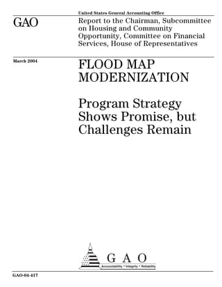
  • 2. March 2004 FLOOD MAP MODERNIZATION Program Strategy Shows Promise, but Challenges Remain Highlights of GAO-04-417, a report to the Chairman, Subcommittee on Housing and Community Opportunity, Committee on Financial Services, House of Representatives Flood maps identify areas at Through its map modernization program, FEMA intends to use advanced greatest risk of flooding and technologies to produce more accurate and accessible digital flood maps provide the foundation for the available on the Internet. These maps are expected to improve community National Flood Insurance Program efforts to reduce the impact of floods, increase property owners’ use of flood (NFIP) managed by the Federal insurance, and improve community, state and federal efforts to reduce the Emergency Management Agency risks of other natural and man-made hazards. (FEMA). The maps are used by (1) communities to establish In developing digital flood maps, FEMA plans to incorporate data that are of minimum building standards a level of specificity and accuracy commensurate with communities’ relative designed to reduce the impact of flood risk. According to FEMA, there is a direct relationship between the flooding, (2) FEMA to set insurance types, quantity, and detail of the data and analysis used to develop maps and rates, and (3) lenders to identify property owners who are required the costs of obtaining and analyzing those data. Although FEMA ranked the to purchase flood insurance. Nearly nation’s 3,146 counties from highest to lowest risk, it has not yet established 70 percent of all flood maps are data standards that describe the appropriate level of detail, accuracy, and more than 10 years old, according analysis required to develop digital maps based on risk level. Without such to FEMA. In an effort to update its standards, FEMA cannot ensure that it uses the same level of data collection flood maps, FEMA is implementing and analysis for all communities in the same risk category. Such standards a $1 billion, 5-year map can also help FEMA to target its map modernization resources more modernization program. GAO was efficiently by matching the level of data collection and analysis with the level asked to review the progress of of flood risk. FEMA’s map modernization program. FEMA has developed partnerships with states and local entities that have begun mapping activities and has a strategy on how to best work with these entities. However, the overall effectiveness of FEMA’s future partnering To help ensure that FEMA’s map efforts is uncertain because FEMA has not yet developed a clear strategy for modernization program achieves partnering with communities with less resources and little or no experience its intended benefits, GAO is in flood mapping. By developing such a strategy, FEMA will be better able to making several recommendations. identify and use the most effective approaches to engage all of its partners in FEMA should address differences map modernization. among the communities for which flood maps are being developed— Comparison of Old Paper and New Digital Map Sections in North Carolina whether those differences arise from different levels of flood risk or different levels of capacity and resources to assist with flood mapping. www.gao.gov/cgi-bin/getrpt?GAO-04-417. To view the full product, including the scope and methodology, click on the link above. For more information, contact William O. Paper flood map section Digital flood map section Jenkins, 202-512-8777, jenkinswo@gao.gov. Source: North Carolina Department of Emergency Management.
  • 3. Contents Letter 1 Results in Brief 3 Background 5 Map Modernization Intends to Use Advanced Technologies to Produce More Accurate and Accessible Digital Flood Maps 9 FEMA Expects Map Modernization to Increase the Likelihood Maps Will Be Used for Risk Management 16 FEMA’s Strategy for Map Modernization Shows Promise, but Challenges Remain 29 Conclusions 40 Recommendations 41 Agency Comments 42 Appendix I Objectives, Scope, and Methodology 44 Appendix II Users of Flood Maps 47 Appendix III GAO Contacts and Staff Acknowledgments 49 GAO Contacts 49 Staff Acknowledgments 49 Table Table 1: FEMA’s Objectives for Map Modernization and Our Observations on the Objectives and Challenges 30 Figures Figure 1: Age of the Nation’s Current Flood Map Inventory 9 Figure 2: Key GIS Layers or Themes for Digital Flood Maps 11 Figure 3: Comparison of Original and Updated Floodplain for Plum Creek in Douglas County, Colorado 13 Figure 4: Use of LIDAR Technology 15 Figure 5: Comparison of Old Paper and New Digital Map Sections in North Carolina 16 Figure 6: Expected Benefits of Map Modernization 18 Page i GAO-04-417 Flood Map Modernization
  • 4. Figure 7: Comparison of FEMA and Sarasota County Floodplain after Remapping 20 Figure 8: Impact of Capital Improvement Project on Floodplain in Sarasota County 22 Figure 9: Expanded Floodplain Boundary for Regulating New Construction in Mecklenburg County, North Carolina 23 Figure 10: Flooding in Greenville, North Carolina, during Hurricane Floyd 27 Figure 11: Example of Spill Response Model in Harris County, Texas 28 Figure 12: Comparison of Cumulative FEMA Funding for Mapping Data with the Total Cumulative Dollar Value of Mapping Data Produced through CTP Program 36 Figure 13: Status of Remapping in North Carolina 38 Abbreviations CTP Cooperating Technical Partner DHS Department of Homeland Security FEMA Federal Emergency Management Agency GIS Geographic Information Systems LIDAR Light Detection and Ranging NFIP National Flood Insurance Program This is a work of the U.S. government and is not subject to copyright protection in the United States. It may be reproduced and distributed in its entirety without further permission from GAO. However, because this work may contain copyrighted images or other material, permission from the copyright holder may be necessary if you wish to reproduce this material separately. Page ii GAO-04-417 Flood Map Modernization
  • 5. United States General Accounting Office Washington, DC 20548 March 31, 2004 The Honorable Robert W. Ney Chairman Subcommittee on Housing and Community Opportunity Committee on Financial Services House of Representatives Dear Mr. Chairman: Floods inflict more damage and economic losses upon the United States than any other natural disaster. During the 10 years from fiscal year 1992 through fiscal year 2001, flooding caused over 900 deaths and resulted in approximately $55 billion in damages.1 Since its inception 36 years ago, the National Flood Insurance Program (NFIP) has combined the development of flood maps to identify the areas at greatest risk of flooding with mitigation2 efforts to reduce or eliminate flood risks to people and property and the availability of insurance that property owners can purchase to protect themselves from flood losses. To date, the flood insurance program has paid about $12 billion in insurance claims, primarily from policyholder premiums, that otherwise would have been paid, at least in part, from taxpayer-funded disaster relief. The Federal Emergency Management Agency (FEMA) is responsible for managing the NFIP, including the development of flood maps.3 Accurate flood maps that identify the areas at greatest risk of flooding are the foundation of the NFIP. The maps are principally used by (1) the 1 Data are from the U.S. Army Corps of Engineers in cooperation with the National Weather Service. 2 Mitigation is defined by the Federal Emergency Management Agency as sustained action that reduces or eliminates long-term risk to people and property from hazards and their effects. 3 Prior to March 2003, FEMA was an independent agency whose Federal Insurance and Mitigation Administration was responsible for managing the flood insurance program. The Homeland Security Act of 2002, P.L. 107-296 (Nov. 25, 2002), transferred FEMA and all its responsibilities to the Emergency Preparedness and Response Directorate within the new Department of Homeland Security. This transfer was effective March 1, 2003. Currently, the Mitigation Division within FEMA is responsible for the flood insurance program, including flood map modernization. Page 1 GAO-04-417 Flood Map Modernization
  • 6. approximately 20,000 communities participating in the NFIP to adopt and enforce the program’s minimum building standards for new construction within the maps’ identified floodplains, (2) FEMA to develop accurate flood insurance policy rates based on flood risk, and (3) federally regulated mortgage lenders to identify those property owners who are statutorily required to purchase federal flood insurance. Under the National Flood Insurance Act of 1968, as amended,4 property owners whose properties are within the designated floodplain and have a mortgage from a federally regulated financial institution are required to purchase federal flood insurance. Flood maps can become outdated for a variety of reasons, such as erosion or community growth and development that can affect the drainage patterns of rainwater. Thus, flood maps must be periodically updated to assess and map changes in the boundaries of floodplains that result from community growth, development, erosion, and other factors that affect the boundaries of areas at risk for flooding. According to FEMA, limited funding for flood mapping has resulted in a backlog of outdated maps. FEMA estimates that as of March 2004 nearly 70 percent of the nation’s flood maps were more than 10 years old and reflected outdated data that could affect the ability to accurately identify current flood hazard areas. With congressional support and funding, FEMA has embarked on a $1 billion, 5-year effort to update the nation’s flood maps. Recognizing that FEMA is currently in the early stages of its map modernization effort, our objectives for this review were to answer the following questions: (1) How is map modernization intended to improve the accuracy and accessibility of the nation’s flood maps? (2) What are the expected benefits of more accurate and accessible flood maps? (3) To what extent does FEMA’s strategy for managing the map modernization program support the achievement of these benefits and what, if any, limitations could affect the implementation of the strategy? To answer these questions, we analyzed available information from FEMA on the program’s purpose, objectives, and status and met with agency officials in headquarters and in the regional offices to discuss the program’s progress. We also conducted site visits to states and communities that have already begun to modernize their flood maps and interviewed industry organizations such as the Association of State Flood Plain Managers, the National Association of Flood and Stormwater 4 See 42 U.S.C. 4001 et seq. Page 2 GAO-04-417 Flood Map Modernization
  • 7. Management Agencies, and the National Emergency Management Association. We conducted our work from April 2003 to March 2004 in accordance with generally accepted government auditing standards. See appendix I for more details on our scope and methodology. Through map modernization, FEMA intends to produce more accurate and Results in Brief accessible flood maps by using advanced technology to gather accurate data and make the flood maps, and the digital information on which they are based, available on the Internet. For example, displaying map data in digital Geographic Information Systems format permits consistent, accurate display and ready electronic retrieval of a variety of map features, including elevation data and the location of key infrastructure, such as utilities. According to FEMA, nearly 70 percent of the nation’s approximately 92,222 flood maps are more than 10 years old, and many of these maps no longer reflect current flood hazard risks because of such changes as erosion and development that can alter drainage patterns and thus the areas at highest risk of flooding. Moreover, since many flood maps were created or last updated, there have been improvements in the techniques for assessing and displaying flood risks. FEMA expects that by producing more accurate and accessible digital flood maps through map modernization, the nation will benefit in three ways. First, communities can use more accurate digital maps to reduce flood risk within floodplains by more effectively regulating development through zoning and building standards. Second, accurate digital maps available on the Internet will facilitate the identification of property owners who are statutorily required to obtain or who would be best served by obtaining flood insurance. Third, accurate and precise data will help national, state, and local officials to accurately locate infrastructure and transportation systems (e.g., power plants, sewage treatment plants, railroads, bridges, and ports) to help mitigate and manage risk for multiple hazards, both natural and man-made. FEMA’s strategy for managing map modernization is designed to support the expected program benefits, but FEMA’s approach to implementing the strategy raises several concerns that could hamper the agency’s efforts. FEMA’s implementation approach is based on four objectives: (1) establish and maintain a premier data system, (2) expand outreach and better inform the user community, (3) establish and maintain effective partnerships, and (4) achieve effective program management. Establish and maintain a premier data system: Although FEMA’s • efforts to establish a new data system could result in more accurate Page 3 GAO-04-417 Flood Map Modernization
  • 8. flood maps and make it easier to access and use the revised flood maps, FEMA has not yet established clear standards for the types, quantity, and specificity of data collection and analysis associated with different levels of flood risk. FEMA has ranked the nation’s 3,146 counties from highest to lowest flood risk. According to FEMA, communities at the highest risk of flooding require the most extensive, detailed data and analysis, but the same level of data collection and analysis may not be necessary to create accurate, useful maps for communities with lower flood risks. Defining the level of data collection and analysis for different levels of risk is important because obtaining and analyzing flood map data is time-consuming and expensive, and the more detailed and specific the data, generally the greater the effort and costs required to obtain it. By identifying the types, quantity, and specificity of the data and analysis needed for communities based on their risk, FEMA can better ensure that data collection and analysis is consistent for all communities with similar risk and that it is using its resources efficiently while producing maps that are accurate and useful for communities at different levels of flood risk. FEMA acknowledges the need to develop such standards, but has not yet developed draft standards or included this task into its map modernization implementation plan. Expand outreach and better inform the user community: FEMA’s • planned expanded outreach efforts are intended to increase public awareness and obtain community acceptance of the updated flood maps because the updated information could potentially identify changes in floodplain boundaries and, therefore, affect property owners, including whether or not their property’s location may require them to purchase federal flood insurance. FEMA’s intended outcome for these outreach efforts is to reduce community vulnerability to natural and man-made hazards and increase participation in the flood insurance program. Because FEMA does not have the authority to require that affected property owners take steps to mitigate their properties against flood risks or to ensure that owners whose properties are in the floodplain purchase flood insurance, effective outreach is essential to ultimately achieve these benefits. Establish and maintain effective partnerships: FEMA’s objective • for building and maintaining mutually beneficial partnerships is designed to facilitate and support the efficient production and effective use of maps. FEMA recognizes that local, state, and federal agencies, that have been working on mapping activities for years, have the resources and potential to positively affect the quality and quantity of the data collected and improve the way these data are used. In Page 4 GAO-04-417 Flood Map Modernization
  • 9. addition, these partnerships can enable FEMA to leverage its resources and reduce the federal costs of map modernization. FEMA has developed a strategy for partnering with these agencies to encourage greater involvement in map modernization, including the contribution of resources. However, the overall effectiveness of the agency’s future partnering efforts is uncertain because FEMA has not yet developed a clear strategy for partnering with communities that have few resources, limited mapping capability, and little history of flood mapping activities. Achieve effective program management: In March 2004, FEMA • awarded a performance-based contract to a single contractor to oversee map modernization that includes performance measures to gauge the success of its efforts. Through a staffing analysis, FEMA has determined that it needs 75 staff with specific, identified skills to effectively monitor and manage the contract and overall map modernization program. As of March 2004, FEMA had hired 1 of the 75 staff, had developed plans to hire or transfer 43 others, but had not yet determine how it would acquire the remaining 31 positions. FEMA has not clearly defined performance measures related to whether (1) the revised maps meet any established standards for accuracy and (2) outreach efforts have been successful in increasing the community and individual awareness and use of flood maps. To help ensure that FEMA’s map modernization program achieves its intended benefits, we make recommendations to the Secretary of Homeland Security to direct the Undersecretary of Emergency Preparedness and Response to address data and analysis standards, partnering with state and local governments, and program management. We provided a copy of our draft report to the Department of Homeland Security (DHS) for comment. In its oral comments, DHS generally concurred with the report’s findings and recommendations and provided technical comments that we incorporated where appropriate. FEMA is the primary federal agency responsible for assisting state and Background local governments, private entities, and individuals to prepare for, mitigate, respond to, and recover from natural disasters, including floods. FEMA’s NFIP has served as a key component of the agency’s efforts to minimize or mitigate the damage and financial impact of floods on the public, as well as to limit federal expenditures needed after floods occur. Page 5 GAO-04-417 Flood Map Modernization
  • 10. In 1968, to address the increasing amount of flood damage, the lack of readily available insurance for property owners, and the cost to the taxpayer for flood-related disaster relief, the National Flood Insurance Act of 1968,5 created the NFIP. Since its inception, the program has sought to minimize flood-related property losses by making flood insurance available on reasonable terms and encouraging its purchase by people who need flood insurance protection—particularly those living in the areas at highest risk of flooding known as special flood hazard areas. The program identifies and maps flood-prone areas in the country, makes flood insurance available to property owners in the nearly 20,000 communities that currently participate in the program,6 and requires floodplain management efforts to mitigate flood hazards on the part of participating communities. FEMA’s flood maps are one of the basic, essential tools for flood hazard mitigation in the United States. FEMA estimates that the maps are used an estimated 30 million times annually in the private and public sectors. FEMA uses the maps to identify the floodplain boundaries in which flood insurance is required and to set flood insurance rates. Mortgage lending institutions use the maps to determine who is required to purchase flood insurance and ensure that flood insurance is purchased and maintained for these properties. Community planning officials, land developers, and engineers use the maps for designing new buildings and infrastructure to be safe from flooding. See appendix II for more information on the various stakeholders that use and rely upon flood maps. Flood maps provide the basis for establishing floodplain building standards that participating communities must adopt and enforce as part of the program. For a community to participate in the program, any structures built within special flood hazard areas—also known as 100-year floodplains7—that have a 1 percent or greater chance of experiencing flooding in any given year must be built according to the program’s building standards whose purpose is to minimize flood losses. A key component of the program’s building standards that must be followed by participating communities is a requirement that the lowest floor of the 5 P.L. 90-448, (Aug. 1, 1968). 6 Also included are Puerto Rico and the Virgin Islands. 7 For clarity and ease of discussion throughout the report, we use the term “floodplain” in all discussions where we address the special flood hazard area or 100-year floodplain. Page 6 GAO-04-417 Flood Map Modernization
  • 11. structure be elevated to or above the base flood level—the elevation at which there is a 1 percent chance of flooding in a given year. The administration has estimated that local governments’ compliance with the program’s standards for new construction is saving over $1 billion annually in flood damage avoided. Flood maps also provide the basis for setting insurance rates and identifying properties whose owners are required to purchase flood insurance. When the NFIP was created, the purchase of flood insurance was voluntary. To increase the impact of the program, however, Congress amended the original law in 1973 to require the purchase of flood insurance in certain circumstances. Flood insurance is required for structures in special flood hazard areas of communities participating in the program if (1) any federal loans or grants were used to acquire or build the structures or (2) the structures have outstanding mortgage loans made by lending institutions that are regulated by the federal government. Owners of properties without mortgages or properties with mortgages held by unregulated lenders were not, and still are not, required to purchase flood insurance, even if the properties are in special flood hazard areas. Federal regulations require that FEMA communicate potential changes in flood risk to the public when it decides to initiate a flood mapping study and when it is ready to release preliminary maps. At the beginning of the mapping process, FEMA is required to notify community stakeholders.8 When FEMA is ready to release preliminary maps, the agency must publish the proposed base flood elevations in the Federal Register for public comment and notify the community of the results of the study.9 When the final map is approved and implemented, FEMA publishes another Federal Register notice.10 8 FEMA is required to contact community stakeholders, such as the state coordinating agency and other appropriate community officials, to discuss the scope and methodology for the proposed flood map study. 44 C.F.R. sec. 66.5. 9 FEMA is required to publish the proposed flood elevations in a prominent local newspaper at least twice during the 10-day period following the notification of the community chief executive officer. Property owners have 90 days from the second newspaper publication to appeal the proposed flood elevations. 44 C.F.R. secs. 67.4, 67.5. 10 Final flood elevations must be published in the Federal Register and copies sent to the community chief executive officer, all individual appellants, and the state-coordinating agency. 44 C.F.R. 67.11. Page 7 GAO-04-417 Flood Map Modernization
  • 12. In the early 1990s, some of the data and information FEMA collected to develop flood maps were becoming available in digital format. In 1994, the President issued Executive Order 12906, which mandated that standards for digital geographic data be applied uniformly across the federal government. Anticipating that electronic data would soon become the standard vehicle for information delivery and in an attempt to make flood map production more cost-effective and efficient, FEMA developed a prototype for a digital flood map. In 1997, FEMA developed its initial flood map modernization plan that outlined the steps necessary to update the nation’s flood maps to digital format and streamline FEMA’s operations in raising public awareness of the importance of the maps and responding to requests to revise them. This initial plan and subsequent updates to the plan reflected the recommendations of the Technical Mapping Advisory Council created by Congress and active from 1995-2000. The council provided a number of recommendations which were aimed at making the digital flood map the future method for assessing flood hazard risk and setting federal insurance rates. Recognizing the importance of updating the nation’s flood maps, Congress appropriated additional funds in fiscal years 2000-2002. FEMA used these funds to launch its map modernization program through such activities as developing new flood mapping standards and procedures, expanding the Cooperating Technical Partner (CTP) program that recognizes and encourages state and local participation in flood hazard data development and maintenance and developing some digital flood maps. In fiscal year 2003, Congress appropriated $150 million, allowing FEMA to initiate a full-scale update of the nation’s flood maps called the Multi-Hazard Flood Map Modernization Program,11 an effort FEMA expects to take about 5 years and cost about $1 billion. In fiscal year 2004, Congress appropriated an additional $200 million for map modernization, and the administration has requested an additional $200 million for fiscal year 2005 to continue the program. FEMA has established four primary objectives for implementing map modernization: (1) establish and maintain a premier data collection and delivery system, (2) expand outreach and better inform the user community, (3) build and maintain mutually beneficial partnerships, and (4) achieve effective program management. In March 2004, FEMA awarded a performance-based 11 For clarity and ease of discussion throughout the report, we use the term “map modernization” in all discussions where we address the Multi-Hazard Flood Map Modernization Program. Page 8 GAO-04-417 Flood Map Modernization
  • 13. contract for overseeing map modernization that includes contractor performance measures for each of these objectives. Through map modernization, FEMA intends to produce more accurate and Map Modernization accessible flood maps by using advanced technology to gather accurate Intends to Use data and make the resulting information available on the Internet. Currently, many of the flood maps in FEMA’s inventory do not accurately Advanced reflect the true flood hazard risks because over time, new development Technologies to and other factors altered watersheds and floodplains faster than the maps could be updated. For the most part, the $35 million to $50 million in Produce More annual flood insurance policy fees has been the only source of funding for Accurate and updating flood maps, and according to FEMA, the agency has not been able to keep the maps updated with the funds available. As a result, nearly Accessible Digital 70 percent of the nation’s approximately 92,222 flood maps12 are more than Flood Maps 10 years old and many of these maps reflect inaccurate data, according to FEMA. Figure 1 shows the age distribution of the current map inventory. Figure 1: Age of the Nation’s Current Flood Map Inventory 18% <5 years old 5-10 years old 12% 54% 10-15 years old 16% >15 years old Source: FEMA. Over time, physical conditions in watersheds and floodplains can change, and improvements in the techniques for assessing and displaying flood 12 The 92,222 flood maps represent nearly 20,000 communities. Page 9 GAO-04-417 Flood Map Modernization
  • 14. risks are made. FEMA plans to use the latest technology, such as Geographic Information Systems (GIS), to create accurate digital flood maps. GIS technology provides the foundation for achieving FEMA’s goals of melding different types and sources of data to create the new digital flood maps and making the new digital flood maps available to a variety of users over the Internet. The primary function of GIS is to link multiple digital databases and graphically display that information as maps with potentially many different types of “layers” of information. When layers of information are formatted using the same standards, users can potentially overlay various layers of information about any number of specific topics to examine how the layers interrelate. Each layer of a GIS map represents a particular “theme” or feature, and one layer could be derived from a data source completely different from the other layers. For example, one theme could represent all the streets in a specified area. Another theme could correspond to the topography or elevation data of an area, and others could show aerial photography and streams in the same area. These themes are all key elements needed to create flood maps that accurately depict floodplains and can be used to identify properties in these areas. In preparing for full-scale implementation of map modernization, FEMA has established standards and graphic specifications for digital flood maps created with GIS. Figure 2 shows the concept of data themes in GIS for flood maps. Page 10 GAO-04-417 Flood Map Modernization
  • 15. Figure 2: Key GIS Layers or Themes for Digital Flood Maps Source: FEMA. Page 11 GAO-04-417 Flood Map Modernization
  • 16. GIS technology also enables the creation of more accurate and accessible maps than would be possible with older mapping methods and technology. The majority of FEMA’s flood map inventory was produced using manual techniques that have inherent accuracy and accessibility limitations. For example, in creating traditional paper flood maps, field measurements taken by surveyors would have been transferred by hand to paper base maps. If the paper base map contained any inaccuracies, then the field- survey data could be shown in the wrong place on the final flood map. This would then result in floodplain boundaries being shown in the wrong place. Recent remapping efforts in Douglas County, Colorado, show the accuracy Douglas County, Colorado of digital maps using GIS technology compared with paper maps created using manual techniques. As seen in figure 3, some areas (around cross section J) shown outside the floodplain on the original map will be shown in the floodplain based on the updated flood hazard information from a new mapping study using GIS technology. More critically, some areas shown outside the floodplain on the original map will now be shown in the floodway, the most dangerous area of the floodplain (greatest depth, highest flood water velocity). According to FEMA and community officials, the limitations of the manual techniques used to create the original map contributed to the resulting inaccuracy. Page 12 GAO-04-417 Flood Map Modernization
  • 17. Figure 3: Comparison of Original and Updated Floodplain for Plum Creek in Douglas County, Colorado Cross section J Updated floodway Updated floodplain Original floodway Original floodplain Source: FEMA and Denver Urban Drainage and Flood Control District. Using GIS technology to create digital flood maps minimizes mapping errors and improves accuracy because each data component (e.g., streams, streets, etc.) would have a common geographic reference system. By their nature, paper flood maps have limited accessibility as compared with a digital map that can be made available on the Internet. The expansion of Internet connectivity in recent years has substantially Page 13 GAO-04-417 Flood Map Modernization
  • 18. enhanced the potential value of digital maps created with GIS because now it is possible to locate and connect data from many distinct GIS databases to develop analytical information on almost any topic that is associated with physical locations. Digital flood maps created according to FEMA’s standards are intended to provide users not only with the ability to determine the flood zone and base flood elevations for a particular location, but also with the ability to access other information like road, stream, and public land survey data. Communities could use this information for a variety of purposes, including decisions on future development and evacuation routes. As part of map modernization, FEMA has promoted the use of a variety of advanced technologies to improve the accuracy of flood maps. In recent years, for example, where it deems it appropriate, FEMA has promoted the use of Light Detection and Ranging (LIDAR) remote sensing technologies to generate highly detailed, digital elevation data. Elevation data are a key component needed to determine flood risk and identify floodplain boundaries. According to FEMA, for very flat areas where small changes in elevation can have a large impact on where flood plain boundaries are drawn, LIDAR can provide the level of detail needed to accurately delineate these boundaries. Communities can also use detailed, digital elevation data for planning and land development purposes. Figure 4 shows an airplane equipped with laser-pulsing sensors using LIDAR to gather digital elevation data to measure the contours and crevices that determine where floodwaters collect. Page 14 GAO-04-417 Flood Map Modernization
  • 19. Figure 4: Use of LIDAR Technology Laser scanner Source: Harris County Flood Control District. The state of North Carolina has been utilizing GIS and LIDAR technology North Carolina’s Use of GIS to develop new flood maps. As of February 2004, 8 counties had received and LIDAR to Develop and new effective flood maps, and 28 counties received new preliminary maps, Deliver Revised Flood Maps which are now under community review. The state has gathered elevation data through LIDAR for 80 percent of the state. The maps and LIDAR and other data can be freely accessed and downloaded by anyone who has access to the Internet (http://www.ncfloodmaps.com). The state, dependent on continued FEMA funding, expects to have the entire state remapped by 2008. Figure 5 compares a digital flood map section produced by North Carolina with the same area on the original paper map. Page 15 GAO-04-417 Flood Map Modernization
  • 20. Figure 5: Comparison of Old Paper and New Digital Map Sections in North Carolina Paper flood map section Digital flood map section Source: North Carolina Floodplain Mapping Program. FEMA expects map modernization to increase the likelihood that the more FEMA Expects Map accurate and accessible maps will be used for risk management purposes. Modernization to Specifically, FEMA expects the new maps to be used to (1) improve flood mitigation, (2) increase flood insurance participation, and (3) improve Increase the “multi-hazard” mitigation and risk management capabilities. First, FEMA Likelihood Maps Will expects communities to be able to use these new and revised maps to better manage and mitigate flood risk by regulating floodplain Be Used for Risk development through building codes, ordinances, and regulations. Second, Management the new maps also have the potential to help increase flood insurance participation because they will more accurately identify those properties that are in the floodplain and whose owners would be required to purchase flood insurance. Compared with the existing paper maps, accessing the new maps through the Internet will make it much easier for lenders to identify property owners who should have flood insurance. In addition, the newly revised flood maps should more accurately identify all Page 16 GAO-04-417 Flood Map Modernization
  • 21. properties in the floodplain, including those whose owners do not have a mortgage or whose mortgage is held by a lender that is not federally regulated. Accurately identifying these property owners should assist FEMA and communities in targeting their outreach about the importance of flood insurance. Third, the data and infrastructure developed by map modernization is also expected to help national, state, and local officials mitigate and manage risk from multiple hazards, both natural and man- made. Accurate digital maps can provide more precise data on such things as the location of hazardous material facilities, power plants, railroads, and airports to state and national officials for planning development as well as to assess internal weaknesses and evacuation routes. (Fig. 6 highlights these expected benefits.) Page 17 GAO-04-417 Flood Map Modernization
  • 22. Figure 6: Expected Benefits of Map Modernization Map Modernization More accurate and accessible digital flood maps NFIP Other benefits benefits Increased flood Improved multi- Improved flood insurance hazard mitigation and mitigation participation risk management Mandatory Voluntary Voluntary Mandatory Adoption and Capital improvement Purchase of insurance Purchase of insurance enforcement of projects and by others who would enforced by lenders building standards enhanced standards benefit Source: GAO. Map Modernization Is The more accurate and updated flood hazard information produced through map modernization is expected to help improve flood mitigation Expected to Improve in participating communities. The NFIP requires participating Flood Mitigation communities to adopt and enforce building standards based on the floodplain boundaries and base flood elevations when maps are updated. For example, the lowest floor of structures in new construction must be elevated to at least the base flood elevations identified on the maps. FEMA’s policy is to monitor communities to ensure that they have adopted building standards that meet the minimum NFIP criteria and to ensure that they are effectively enforcing these standards. If communities fail to establish and enforce minimum NFIP flood plain building standards, FEMA can suspend availability of federal flood insurance. Communities also may use updated flood hazard data to take actions to mitigate flooding that go beyond adopting the building standards required by the NFIP. For example, communities may use the data from the maps to identify where to conduct capital improvement projects designed to Page 18 GAO-04-417 Flood Map Modernization
  • 23. mitigate flooding of structures in the floodplain. In addition, FEMA has established a Community Rating System that provides discounts on flood insurance premiums for those communities that take mitigation actions beyond those required by the NFIP. Sarasota County, Florida, is in the process of modernizing its flood maps Sarasota County’s Use of Flood and has been using the maps and the models behind them to implement Map Data for Storm Water stormwater capital improvement projects whose purpose is to mitigate the Capital Improvement Projects flood risk for structures now located in the floodplain. These efforts have also resulted in lower insurance premiums for property owners. In the late 1990s, because Sarasota County officials believed that current maps did not accurately reflect changes to the floodplain that had occurred due to development and other factors, they began an effort to aggressively remap the county’s watersheds using GIS and new flood modeling technologies. At the time, the county had experienced several significant flooding events where hundreds of properties not depicted in the floodplain on its 11-year old maps were damaged. Figure 7 shows both the increase and decrease in the floodplain based on the county’s remapping efforts. Page 19 GAO-04-417 Flood Map Modernization
  • 24. Figure 7: Comparison of FEMA and Sarasota County Floodplain after Remapping Coastal floodplain - not studied Reduction in FEMA floodplain Floodplain unchanged Expanded county floodplain Source: Sarasota County Center for Watershed Management. The county has been using the maps to implement storm water improvement projects such as retention ponds and levees that are designed to improve drainage and, therefore, alter the floodplain. Ultimately, these projects would result in structures no longer being in the floodplain. County officials estimate that they have reduced the number of structures in the floodplain by 75 percent (from 800 to under 200) through Page 20 GAO-04-417 Flood Map Modernization
  • 25. these projects. According to these officials, the reduction in their Community Rating System rating from an 8 to a 6 was due in large part to their remapping efforts. They estimate that this reduction is saving the community over $1 million a year in flood insurance premiums. Figure 8 shows an example of the impact one such capital improvement project had on the floodplain in Sarasota County. Page 21 GAO-04-417 Flood Map Modernization
  • 26. Figure 8: Impact of Capital Improvement Project on Floodplain in Sarasota County Bahia Vista/Lockwood Ridge before levee project: 1962 flooding. Bahia Vista/Lockwood Ridge Levee Project: post project picture. Levee project Revised floodplain Historical floodplain removed by levee project Source: Sarasota County Center for Watershed Management. Mecklenburg County, Mecklenburg County, North Carolina, provides another example of how communities may use revised maps as a basis for adopting and enforcing North Carolina building standards that exceed the standards required by the NFIP. Page 22 GAO-04-417 Flood Map Modernization
  • 27. In February 2004, Mecklenburg County, North Carolina, issued final digital maps that not only show the floodplain boundaries and base flood elevations used by FEMA to set insurance rates, but also include local land use maps designed to guide future development. (See fig. 9.) These maps are more restrictive than the FEMA maps, which are used for setting insurance rates. The county uses these maps to require that the lowest floor of all new construction is built an additional foot above the future minimum base flood elevation identified by the map. Engineering and economic studies estimate that this higher standard will save over $300 million in structure and content losses due to future flooding. As in the case of Sarasota County, adopting these higher standards should result in a better Community Rating System rating for the county and reduce insurance rates for property owners. Figure 9: Expanded Floodplain Boundary for Regulating New Construction in Mecklenburg County, North Carolina Future land use floodplain FEMA floodplain Source: Charlotte-Mecklenburg Storm Water Services. Map Modernization Is Map modernization has the potential to help increase flood insurance participation. The accuracy of the new maps should better identify at-risk Expected to Help Increase property owners who would be best served by obtaining flood insurance Flood Insurance whether or not the owners would be required to purchase insurance under Participation the NFIP’s mandatory purchase requirement. Moreover, the digital, GIS- based maps should make flood risk information more accessible to a Page 23 GAO-04-417 Flood Map Modernization
  • 28. variety of users such as lenders and community officials who could conduct targeted outreach at these property owners. Recent outreach activities conducted during remapping in Wilson and Outreach Efforts in Wilson and Johnston counties in North Carolina provide an example of the types of Johnston Counties, North information that can be provided to communities and property owners Carolina through outreach efforts during map modernization. As part of its map modernization program, the state of North Carolina holds two meetings. The first meeting is held with the county and community officials and floodplain administrators, and the second meeting is open to the general public. The purpose of the meetings is to provide an overview of the state’s program; an outline of flood hazard data changes between the current maps and preliminary revised maps; and guidance on the use of the maps, including how to view and download data from the state’s Web site. After the state had completed preliminary studies and maps for Wilson and Johnston counties, community officials used the digital, GIS-based maps to identify structures that are located in the newly identified floodplain. The counties then sent out letters to these property owners that notified them that their property was in a floodplain, • provided a telephone number to call for more information, • announced upcoming public meetings where the preliminary maps • would be discussed, and identified the state’s Internet site where the flood maps could be • viewed (Wilson County). By providing this information in advance, property owners could know before the meeting whether their property was in the newly designated floodplain. According to community officials, their outreach activities provided the information necessary for the public to become aware of their risk and know what actions could be taken to mitigate these risks. It is important to note, however, that FEMA, states, and communities do not have the authority to ensure that property owners who are subject to the mandatory purchase of flood insurance requirement actually purchase flood insurance. It is the federally regulated lenders’ responsibility to ensure that borrowers purchase flood insurance and that the insurance policy is maintained throughout the loan’s life as each new lender Page 24 GAO-04-417 Flood Map Modernization
  • 29. servicing the loan becomes aware that the affected property is at risk for flooding. Furthermore, owners of properties without mortgages or properties with mortgages held by unregulated lenders are not required to purchase flood insurance, even if the properties are in floodplains. Map Modernization Is FEMA expects that the data developed, collected, and distributed through map modernization will help national, state, and local emergency Expected to Improve managers mitigate and manage risk posed by other natural and man-made Multi-Hazard Mitigation hazards. Accurate digital base maps provide more precise data to state and and Risk Management national officials for planning, such as the location of hazardous material Capabilities facilities, power plants, utility distribution facilities, and other infrastructure (bridges, sewage treatment plants, buildings, and structures). According to FEMA, map modernization will also support DHS’s overall goal to reduce the nation’s vulnerability to terrorism by providing GIS data and capabilities to other departmental functions. For example, more accurate information on transportation systems such as railroads, airports, harbors, ports, and waterways should be helpful in assessing internal weaknesses and evacuation routes. North Carolina’s use of information collected during flood mapping to Flood-Inundation Application develop a flood-inundation application exemplifies how the data collected Developed by North Carolina through map modernization can be used for other risk management purposes. Leveraging the work done through the floodplain mapping program, North Carolina is in the process of establishing a real-time flood-inundation and flood forecast mapping Web application that will provide the public with valuable safety information during weather events. During a storm, the application will provide maps and information over the Internet that display which land area, roads, and bridges are inundated by floodwaters. Furthermore, to help ensure that the public is aware of high flood risk areas, the state plans to develop an automated alert network that will utilize different media to notify and warn emergency managers, law enforcement, and the general public. North Carolina is currently working with television broadcasters in the region to broadcast warnings and up- to-date safety information based upon information provided through the Web application. The majority of deaths during Hurricane Floyd, which hit North Carolina in 1999, occurred to individuals driving over flood- inundated roads and bridges. North Carolina hopes that their real-time and forecasted inundation mapping application will help to prevent such deaths during future storm events. Page 25 GAO-04-417 Flood Map Modernization
  • 30. The flood forecasting component of North Carolina’s flood-inundation and forecasting application was recently tested during Hurricane Isabel, which struck in September of 2003. Using data collected by North Carolina, the National Weather Service released an experimental Peak Forecast Inundation Web site for predicting the flooding effects of the hurricane. This was a new level of capability for the National Weather Service by forecasting flood-inundation throughout a major portion of the river basin rather than focusing solely on fixed forecasting locations. The implementation of this new flood forecasting technology will greatly enhance North Carolina’s flood warning Web application. Figure 10 shows an example of how the flood-inundation application is intended to work. As floodwaters rise and spread out over the landscape, the flood-inundation application will produce maps to show the extent of flooding and when roads, critical facilities, and other structures will become flooded. The following maps show flooding in Greenville, North Carolina, and are based on flood levels caused by Hurricane Floyd. Page 26 GAO-04-417 Flood Map Modernization
  • 31. Figure 10: Flooding in Greenville, North Carolina, during Hurricane Floyd Ta r R i ve r Ta r R i ve r Greenville Greenville Normal view. September 15, 1999. Ta r R i ve r Ta r R i ve r Greenville Greenville September 17, 1999. September 20, 1999. Source: North Carolina Floodplain Mapping Program. Harris County, Texas, offers another example of how the digital data Harris County, Houston, Texas developed through map modernization could be used to plan for and respond to man-made disasters. To demonstrate the multi-hazard use of the digital data, community officials showed how a spill response model could be developed to determine the path of a petroleum spill at a Houston area refinery. The model, developed with digital data by a private consultant, uses both elevation data and aerial imagery collected through map modernization to provide officials and emergency response personnel critical information to determine the path of a chemical spill and potentially impacted waterways. This information should provide local officials with valuable Page 27 GAO-04-417 Flood Map Modernization
  • 32. information to aid in their mitigation and evacuation efforts and to protect natural habitats. The figure shows how petroleum at a Houston area refinery would probably flow from specific tanks if ruptured. Figure 11: Example of Spill Response Model in Harris County, Texas Source: Harris County Flood Control District. LIDAR data also provide a basis for three-dimensional modeling of the location of buildings, tanks, and equipment that could be used to determine the optimal location for fire-fighting equipment at the same refinery. The reach of a water jet can be placed against the 3-D model to Page 28 GAO-04-417 Flood Map Modernization
  • 33. determine the extent of coverage and identify obscured structures in the “shadow” of other structures that would limit or block the reach of the water jet. This same 3-D model could also be used in a vulnerability analysis to locate potential targets within a given area that are at risk from gunfire or hand-held rockets. FEMA’s strategy for managing map modernization is intended to support FEMA’s Strategy for the achievement of the expected program benefits of improved flood Map Modernization mitigation, increased NFIP insurance participation, and improved multi- hazard mitigation and risk management capabilities. However, FEMA’s Shows Promise, but approach to implementing the strategy poses several challenges that could Challenges Remain hamper the agency’s efforts. FEMA’s approach is based on four objectives. Two objectives FEMA hopes to achieve through map modernization— building and maintaining a premier data collection and delivery system and expanding outreach and better informing the user community—have the potential to improve the use of flood maps for improved flood mitigation and increased NFIP participation, as well as multi-hazard risk management. The other two objectives—building and maintaining mutually beneficial partnerships and achieving effective program management—are intended to facilitate the achievement of the first two objectives and their intended benefits efficiently and effectively. Table 1 provides a brief description of FEMA’s four objectives for map modernization and the challenges facing implementation. Page 29 GAO-04-417 Flood Map Modernization
  • 34. Table 1: FEMA’s Objectives for Map Modernization and Our Observations on the Objectives and Challenges Objective Description GAO Observations Establish and maintain a premier data Create a GIS- and Internet-based system FEMA has ranked the nation’s counties collection and delivery system that provides easy access to reliable flood based on risk. However, FEMA has not yet hazard data and other data collected established data collection and analysis during the mapping process. The system standards for communities with similar risk. will be available to states and communities Without such standards, FEMA cannot to input and use data, therefore, enabling ensure that the level of data collection and easier and less time-consuming data analysis is consistent across all communities maintenance and the use of the with similar risk. information for multi-hazard risk management purposes. Expand outreach and better inform the Raise the awareness of flood map users FEMA’s outreach strategy is based on a user community of their risk of flooding through increased recognition that it has no direct authority to outreach efforts and educate the public on ensure that many map modernization how they can use flood maps and other benefits are achieved, but must rely on hazard data to mitigate natural and man- others—e.g., mitigation efforts by individual made disasters. property owners and lender enforcement of mandatory flood insurance purchase. Build and maintain mutually beneficial Develop strategies for forming and States and communities with limited partnerships enhancing relationships with all states and resources and technical capabilities are likely communities resulting in their active to pose a challenge to FEMA’s ability to fund participation in the production of flood and implement mapping activities. FEMA has hazard data. This is intended to help not yet developed a strategy for how to improve the long-term quality of flood partner with communities that do not have data, ensure that the maps meet local the resources, capabilities, or motivation to needs, and capitalize on local and regional initiate and sustain mapping activities. knowledge and resources to achieve the effective production and efficient use of flood maps at a reduced cost to the federal government. Achieve effective program management Develop a flexible program management Using current staffing levels, FEMA may be structure that clearly evaluates the challenged to effectively oversee the contract program’s performance and identifies and the map modernization program. In continuous improvement strategies to addition, although FEMA has established most effectively and efficiently conduct measures to assess achievement of its mapping activities that result in high- program objectives, its measures for its quality flood maps. objectives to develop a premier data system and to expand outreach and better inform the user community are not clearly defined or fully developed. Source: GAO analysis. In Its Efforts to Establish a The goal of FEMA’s objective to develop a new data system using the latest technology is more efficient production, delivery and, thereby, the New Data System, FEMA use of flood maps. As discussed previously, FEMA hopes to accomplish Has Not Yet Established this by using geographic information systems technology that provides the Data Standards for foundation for the production and delivery of more accurate digital flood Different Levels of Risk maps and multi-hazard data that is more accessible over the Internet. Page 30 GAO-04-417 Flood Map Modernization
  • 35. In developing the new data system to update flood maps across the nation, FEMA’s intent is to develop and incorporate flood risk data that are of a level of specificity and accuracy commensurate with communities’ relative flood risks. According to FEMA, there is a direct relationship between the types, quantity, and detail of the data and analysis used for map development and the costs associated with obtaining and analyzing those data. FEMA believes it needs to strike a balance between the relative flood risk faced by individual communities and the level of analysis and effort needed to develop reliable flood hazard data if it is to update the nation’s maps efficiently and effectively. FEMA has ranked all 3,146 counties from highest to lowest based on a number of factors, including, among other things, population, growth trends, housing units, flood insurance policies and claims, repetitive loss properties, and flood disasters. On the basis of this ranking, FEMA established mapping priorities. However, FEMA has not yet established standards on the appropriate data and level of analysis required to develop maps based on risk level. FEMA has historically applied the same minimum standards for all flood maps and supporting data.13 FEMA’s Guidelines and Specifications for Flood Hazard Mapping Partners provides guidance for selecting the level of analysis and effort to produce flood hazard data and have generally been used on a case-by-case basis.14 The guidelines do not specify standards to be used for all mapping projects within a given risk category. Without establishing standards for different categories of risk, FEMA cannot ensure that it uses the same level of data collection and analysis across all communities within the same risk category. These standards could also provide a consistent basis for estimating the costs of developing maps in each risk category. According to FEMA, the agency plans to develop standards that can be applied to different levels of flood risk as part of a 5-year map modernization implementation plan. FEMA expects this plan to be completed by the end of fiscal year 2004; however, at the time of our review, FEMA had not yet developed draft standards or incorporated this task into its implementation plan. 13 For example, FEMA implemented digital base map standards in 1998 and LIDAR standards in 2000. 14 These guidelines describe detailed methods of analysis used for high-risk areas and less detailed methods used in low-risk areas. Page 31 GAO-04-417 Flood Map Modernization
  • 36. FEMA’s Objective to FEMA’s objective to expand the scope and frequency of its outreach efforts is intended to increase community and public acceptance of Expand Outreach Efforts revised maps and use of those maps. Historically, FEMA has only Recognizes the Agency contacted communities when initiating remapping and again when Must Rely on Others to preliminary maps are completed. These expanded outreach efforts reflect Achieve Map FEMA’s understanding that it is dependent on others to achieve the Modernization Benefits benefits of map modernization. For example, under the structure of the NFIP, FEMA is dependent on communities to adopt and enforce FEMA’s minimum building standards and on mortgage lenders to ensure compliance with mandatory flood insurance purchase requirements. To expand the scope of its outreach efforts, FEMA plans to involve a wide variety of community participants—e.g., mayors, emergency managers, lenders, property owners, insurance agents, and developers—in the mapping process. To expand the frequency of outreach, FEMA intends to increase community involvement, awareness, and participation throughout the entire flood mapping process. Through a continual education process, FEMA’s goal is to inform property owners and others potentially affected by remapping efforts of steps they can take to mitigate the risk of flooding, the types of damage and costs caused by flooding, and the benefits of flood insurance. According to FEMA, if a community is involved in and understands the map modernization process, the community is more likely to accept and trust the accuracy of the final, revised maps and is more likely to use the maps’ hazard data to mitigate natural and man-made disasters. Conversely, if affected property owners do not understand why their communities are being mapped (or remapped) or why their property is now in a flood zone, the unexpected additional expense of new or increased flood insurance premiums can form the basis of significant community opposition to map modernization activities and lead to formal appeals, litigation, and delays in implementing map changes. We visited several communities that have nearly completed or are engaged in revising flood maps and talked with relevant officials about recent mapping projects and the importance of outreach efforts. The experience of Pinellas County, Florida, shows the potential consequences of a limited outreach effort while the experiences of the Harris County Flood Control District in Houston, Texas, and Hillsborough County, Florida, show the potential benefits of a more expanded outreach strategy. Officials in Pinellas County, Florida, rejected revised flood hazard maps Pinellas County, Florida developed by FEMA that raised base flood level elevations and placed Page 32 GAO-04-417 Flood Map Modernization
  • 37. areas in newly established flood zones. According to community and FEMA officials, FEMA did little to communicate with the community and the public during the mapping process. According to FEMA, the agency was only required to inform the community when the remapping project was initiated in 1993 and again after the proposed maps were completed and provided to the community for comment in December 1997. County officials subsequently appealed the preliminary maps. According to local officials, expanded outreach efforts by FEMA throughout this process could have helped the community understand why the county was being mapped and how the new maps reflected the true flood risks of the properties shown in revised flood zones. After working closely with FEMA and mapping contractor officials, the community finally accepted and implemented the maps by establishing new building standards in September 2003. Harris County, Houston, Texas The Harris County Flood Control District in Houston, Texas, took steps to expand stakeholder and community outreach by releasing up to date flood hazard map information on its Web site (http://www.tsarp.org). County officials have also worked closely with the local newspaper to release information on the updated flood hazard information to the public. In addition, the county has held individual meetings with the county’s 35 flood plain managers to ensure that they understood the new flood maps and were able to convey that information to citizens; hired a public relations consultant to provide guidance on how to better utilize the media to disseminate flood map information; and conducted a poll survey to ascertain public opinion about flood hazard risk and to develop strategies to better convey flood hazard information. County officials also developed several committee groups to relay flood maps information that is audience-specific, such as a technical discussion group that reviews technical issues related to revising the flood maps and verifies methodological assumptions. Hillsborough County, Florida Hillsborough County officials have conducted extensive outreach while continuing to work with FEMA throughout the remapping process. To help ensure that insurance companies, real estate agents, county workers, and citizens utilize flood maps in a more efficient and effective manner, a stakeholders outreach coalition was formed in March of 2003. The purpose of this coalition is to create an information campaign for individual property owners and businesses that will be directly impacted by the new maps. The coalition includes representatives from the county’s Citizen Advisory Committee, the insurance industry, real estate brokers, builders, lenders, engineers, surveyors, and various county departments. Hillsborough County is working in cooperation with FEMA to have final Page 33 GAO-04-417 Flood Map Modernization
  • 38. maps in late 2004 and create a successful outreach program that could be duplicated throughout the nation. FEMA’s expanded outreach efforts are intended to educate the public of the potential flood risk in communities and to encourage them to take action. Communities that participate in the NFIP are required to establish floodplain management ordinances that require new and substantially improved structures in newly designated floodplains to meet NFIP building standards. However, if a property was not located in the floodplain in the old map, but is in the floodplain in the new revised map, NFIP floodplain management regulations do not require those owners to implement mitigation measures unless they make substantial improvements to the structure.15 FEMA cannot compel affected property owners to take steps to mitigate their properties against flood risks or to purchase flood insurance. Under current notification requirements, federally regulated lenders, not FEMA, serve as the primary channel for notifying property owners whose mortgaged properties are subject to flood insurance requirements. When property owners seek new financing—through purchase or refinancing—federally regulated mortgage lenders are required to determine if the property is in the floodplain, and, if so, require the purchase of flood insurance. Lenders are not required to monitor map changes or to notify property owners with existing mortgages whose properties are identified in a floodplain by remapping if they are not aware of the change in status.16 Nonetheless, if federally regulated lenders become aware of flood map changes that affect properties for which they hold mortgages through FEMA notifications or flood zone determination companies,17 then they must notify the property owner and require the purchase of flood insurance. The information that must be provided to property owners is 15 If a community determines that the cost of improvements to a home or business equals or exceeds 50 percent of the market value of the building, the building is considered a “substantial improvement” and must meet the NFIP’s minimum requirements. 16 In making loans, federally regulated lenders are required to ensure that property owners purchase flood insurance if their mortgages are secured by a structure located in a floodplain. Lenders are also required to check the flood hazard status of a property when triggered by statutory tripwires, such as loan renewal or extension. 17 Many lenders use flood zone determination companies to determine whether properties require flood insurance as a result of loan origination, loan assumption, or map changes. These companies use FEMA flood maps and other data to ascertain if properties are situated in flood zones. Page 34 GAO-04-417 Flood Map Modernization
  • 39. limited to notifying property owners that their structure is in a floodplain, providing a definition of a flood plain, and requiring the purchase of flood insurance if they live in a participating NFIP community. As a result, FEMA’s outreach efforts are important for supplementing the formal requirements for notifying communities and property owners of map changes. FEMA’s Strategy for FEMA’s objective for building and maintaining mutually beneficial partnerships is intended to facilitate and support the efficient production Partnering with States and and effective use of flood maps. According to FEMA, local, state, and Local Communities Does federal partners that have invested resources and assisted in managing Not Include Communities mapping activities have the potential to positively affect the detail, with Few Resources to accuracy, and quantity of the data collected and improve how these data Assist in Flood Mapping are used. As part of their strategy for partnering, FEMA provides guidance to the states on how to develop “business plans” that document planned efforts to develop states’ and communities’ capability and capacity to oversee the collection, analysis, and implementation of flood data in their state and community and to justify funding for these efforts. According to FEMA, 38 states have begun drafting such plans. FEMA intends to use these state business plans to help prioritize its continuing efforts to develop map modernization partners. Page 35 GAO-04-417 Flood Map Modernization
  • 40. Through its Cooperating Technical Partners (CTP) program, FEMA has developed partnerships with a variety of states and communities that have developed their own data and provided their own funds to help update local flood maps. Since 2000, FEMA has leveraged millions of dollars in funding from 171 partners (states and local communities) for producing maps through its CTP program. For example, from fiscal years 2000 to 2002, FEMA used $70 million of its federal map modernization funding along with state and local funds to develop what FEMA has estimated to be more than $155 million worth of new mapping data. Figure 12 compares FEMA’s cumulative funding for new mapping data through the CTP program with the total cumulative dollar value of data produced with partner contributions since the program was established in 2000. Figure 12: Comparison of Cumulative FEMA Funding for Mapping Data with the Total Cumulative Dollar Value of Mapping Data Produced through CTP Program Dollars (in millions) 200 150 100 50 0 2000 2001 2002 Year Cumulative FEMA funding for new mapping data Total cumulative dollar value of data produced with partner contributions Source: FEMA. According to FEMA, partnering has other benefits as well. For example, in the long-term, those states and communities with whom FEMA has established partnerships may be more likely to accept final map changes, expand their capabilities, and assume greater responsibility for Page 36 GAO-04-417 Flood Map Modernization
  • 41. periodically developing and incorporating updated flood data, resulting in cost savings to FEMA. FEMA’s partnership with the state of North Carolina provides an example of a state assuming greater responsibility for producing and maintaining flood maps. According to North Carolina officials, the devastating flooding and FEMA’s Cooperating Technical subsequent damage that occurred from Hurricane Floyd in 1999 led the Partnership with the State of state of North Carolina to take action to address the limitations of the North Carolina existing FEMA flood maps. Approximately 80 percent of the homes damaged or destroyed during Hurricane Floyd were not depicted in the floodplain on the state’s flood maps. In 2000, North Carolina became the first Cooperating Technical State under FEMA’s CTP program, agreeing to assume primary ownership and responsibility of flood maps for all North Carolina communities. Since then, according to state floodplain mapping officials, the state has contributed approximately $41 million towards the overall floodplain mapping program. On the basis of this amount, North Carolina has covered approximately 65 percent of the total cost to date for the remapping effort. To date, 8 counties had received new effective flood maps and 28 counties received new preliminary maps, which are now under community review. (See fig. 13.) Page 37 GAO-04-417 Flood Map Modernization
  • 42. Figure 13: Status of Remapping in North Carolina Effective maps Preliminary and post preliminary maps Map data review in progress Elevation data created or collected Yet to be studied Source: North Carolina Floodplain Mapping Program. Some states and communities with few resources and technical capacities or little history of flood mapping activities are likely to pose a challenge to FEMA’s ability to fund and implement mapping activities. For example, we talked with flood management officials in several smaller communities in Montgomery County, Texas; Santa Cruz County, Arizona; and Larkspur, Colorado. These officials said that their communities lacked either the funding needed to develop flood data, the technological capability to develop digital flood data and use geospatial information systems, or, in some cases, the community support needed to conduct mapping activities. One approach for obtaining additional resources, capabilities, and community support would be for FEMA to facilitate coordination with other agencies within the state that have a stake in, or could benefit from, mapping activities. For example, state departments of transportation can Page 38 GAO-04-417 Flood Map Modernization