Kansa SAA 2014 Archaeological Data on Vastly Different Scales
•
1 like•1,023 views

Eric Kansa took the lead on presenting “Navigating and Visualizing Archaeological Data on Vastly Different Scales” for coauthors Yerka, Kansa, Anderson, DeMuth and Wells. Archaeological research can focus closely on individual objects, or cover a broad span of time over multiple millennia and continents. Data indexing managed by Open Context for DINAA facilitates these types of multiscalar research, hierarchically nesting both temporal and geographic data with a simplified interface and spectacular visualization.
Recommended

Recommended
More Related Content
What's hot
What's hot (20)
Viewers also liked
Viewers also liked (6)
Similar to Kansa SAA 2014 Archaeological Data on Vastly Different Scales
Similar to Kansa SAA 2014 Archaeological Data on Vastly Different Scales (20)
Recently uploaded
Recently uploaded (20)
Kansa SAA 2014 Archaeological Data on Vastly Different Scales
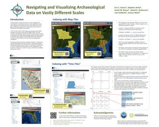
- 1. Navigating and Visualizing Archaeological Data on Vastly Different Scales Introduction Archaeological research can focus on scales ranging from observations on individual objects to macro phenomena that span millennia and continents. Such scalar differences pose a great challenge in digital data dissemination, particularly in finding and visualizing relevant data. Until recently, Open Context (http://opencontext.org) mainly managed site-specific data. But the Digital Index of North American Archaeology (DINAA) project requires Open Context to manage site file data spanning large regions and time periods. To meet this need, Open Context implemented data indexing strategies to hierarchically nest time-span and geographic coordinates. The approach presented here simplifies interface, visualization, and interoperability with Open Context. The nested indexing strategy demonstrated here enables visualization and discovery at a level of spatial resolution that does not compromise site location security, but is useful for map visualization of multiple dimensions of data. Indexing with “Time-Tiles” Eric C. Kansa1, Stephen Yerka2, Sarah W. Kansa3 , David G. Anderson2, Carl DeMuth4, Joshua Wells4 • Web mapping services(Google, Bing, etc.) provide base maps indexed by tiles. Tiling is a widely adopted way to indentify geospatial resources. • Latitude / Longitude (WGS-84) coordinates can be expressed as a hierarchically-encoded string: 37.861844, -122.289677 02301021220232231101 • A nearby coordinate will have a slightly different tile. But note how the left-most characters are the same: 37.861234, -122.276540 02301021220233220031 • Tiles can be easily aggregated at different scales by lumping together characters of the same value from left to right. • Tile strings can be easily converted into map polygons at any scale for visualization of spatially aggregated data. • The DINAA project protects site location data by converting coordinates to tiles limited to 11 characters in length. This corresponds to location accuracy with ~15km to ~ 20km. Indexing with Map-Tiles Further Information To learn more about DINAA, visit the project blog at: http://ux.opencontext.org/blog/archaeology-site-data/ Rough Cilicia Survey (N. Rauh) • Roman era tomb distribution • Small-scale regional data Time ranges can be hard to present in hierarchic faceted search (a standard way to present complex metadata for point-and-click navigation) since ranges do not usually fit into standard buckets. To solve this problem, Open Context will start to organize time-spans using a hierarchy of “tiles,” similar to the map tiles above. 1M-00000000122000110221 (Roman: 2000 – 1470 BP) 1M-01001322312033201102 (Middle Paleolithic: 300KYA – 30KYA) 1M-00000000312010332212 (Iron Age: 3100 – 2500 BP) • Need to define earliest and latest possible dates for a tiling grid • Latest is 0 BP, example below is 1 Million BP (Open Context allows 10MYA). • Recursive function to compute tile from earliest and latest BP date as input. (Source code: https://github.com/ekansa/open-context- code) • Tiles can be converted back to earliest and latest dates. • Like map-tiles above, time-tiles easily aggregate at different scales by lumping together characters of the same value from left to right. Shaded regions show different aggregations of time-tiles. • Tiles allow arbitrary time ranges to be used in faceted search. • Time-tiles can be combined with controlled vocabulary of named periods (in development with DINAA). Florida Site Files (DINAA) • Shell midden distribution • Large-scale region DINAA: 270K+ State Site Files • Unfiltered as of March 31 • Highest tile resolution shown for site location security DINAA: 270K+ State Site Files • Also heat-maps etc. • Lower resolution tile aggregation 1. Open Context (http://opencontext.org) & UC, Berkeley (D-Lab) 2. University of Tennessee, Knoxville 3. Alexandria Archive Institute (http://alexandriaarchive.org) 4. Indiana University, South Bend Acknowledgments DINAA is multi-institutional collaboration funded by a grant from the National Science Foundation Archaeology program. EOL Computational Data Challenge • Percentage of pig bones at sites • Areas represent numbers of bones in different time-ranges in Anatolia Open Context has additional financial support from the National Endowment for the Humanities and other sources. The California Digital Library archives Open Context data.