Regional-Scale Assessment of N2O Emissions within the US Corn Belt: The Impact of Precipitation and Agricultural Drainage on Indirect Emissions
•
1 recomendación•888 vistas

1) Researchers measured nitrous oxide (N2O) emissions from agricultural land and drainage networks in the US Corn Belt to better understand indirect N2O emissions. 2) Chamber measurements showed that N2O emissions decrease with increasing stream order, indicating lower order streams are hotspots for indirect emissions. 3) Inverse modeling using tall tower measurements estimated seasonal indirect N2O emissions from the Corn Belt, finding current estimates underestimate indirect emissions significantly.
Recomendados

Recomendados
Más contenido relacionado
La actualidad más candente
La actualidad más candente (20)
Destacado
Destacado (18)
Similar a Regional-Scale Assessment of N2O Emissions within the US Corn Belt: The Impact of Precipitation and Agricultural Drainage on Indirect Emissions
Similar a Regional-Scale Assessment of N2O Emissions within the US Corn Belt: The Impact of Precipitation and Agricultural Drainage on Indirect Emissions (20)
Más de National Institute of Food and Agriculture
Más de National Institute of Food and Agriculture (20)
Último
Último (20)
Regional-Scale Assessment of N2O Emissions within the US Corn Belt: The Impact of Precipitation and Agricultural Drainage on Indirect Emissions
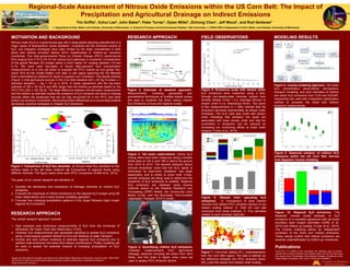
- 1. Regional-Scale Assessment of Nitrous Oxide Emissions within the US Corn Belt: The Impact of Precipitation and Agricultural Drainage on Indirect Emissions Tim Griffis1, Xuhui Lee2, John Baker3, Peter Turner1, Dylan Millet1, Zichong Chen1, Jeff Wood1, and Rod Venterea3 1. Department of Soil, Water, and Climate, University of Minnesota; 2. School of Forestry and Environmental Studies, Yale University; 3. USDA-ARS & Department of Soil, Water, and Climate, University of Minnesota RESEARCH APPROACH FIELD OBSERVATIONS Method tall tower upscaled IPCC+ EDGAR GEIA Regionalflux(nmolm -2 s -1 ) 0.0 0.1 0.2 0.3 0.4 0.5 Surface type corn soybean natural water urban Fluxdensity(nmolm -2 s -1 ) 0.0 0.1 0.2 0.3 0.4 0.5 a b IPCC Agric Non Agric Agric BNF manure residue volatization runoff fertilizer others MOTIVATION AND BACKGROUND Nitrous oxide (N2O) is a greenhouse gas with a large global warming potential and is a major cause of stratospheric ozone depletion. Croplands are the dominant source of N2O, but mitigation strategies have been limited by the large uncertainties in both direct and indirect emission factors (EFs) implemented in “bottom-up” emission inventories. The Inter-governmental Panel on Climate Change (IPCC) recommends EFs ranging from 0.75 to 2% for the various N2O pathways in croplands. Consideration of the global Nitrogen (N) budget yields a much higher EF ranging between 3.8 and 5.1%. We have used two-years of hourly high-precision N2O concentration measurements on a very tall tower to evaluate the IPCC bottom-up and global “top- down” EFs for the United States Corn Belt, a vast region spanning the US Midwest that is dominated by intensive N inputs to support corn cultivation. The results showed (Figure 1) that agricultural sources in the Corn Belt released 420 ± 50 Gg N (mean ± 1 standard deviation; 1 Gg = 109 g) in 2010, in closer agreement with the top-down estimate of 350 ± 50 Gg N and 80% larger than the bottom-up estimate based on the IPCC EFs (230 ± 180 Gg N). The large difference between the tall-tower measurement and the bottom-up estimate implies the existence of N2O emission hot spots or missing sources within the landscape that are not fully accounted for in the IPCC and other bottom-up emission inventories. Reconciling these differences is a crucial step towards developing practical strategies to mitigate N2O emissions. Figure 1: Comparison of N2O flux densities. a) Annual mean flux densities for the surface types in the tall tower footprint. b) Comparison of regional fluxes using different methods. The figure insets show each IPCC component (Griffis et al., 2013) The goals of our current research are therefore to: 1. Quantify the distribution and importance of drainage networks on indirect N2O emissions; 2. Evaluate the magnitude of indirect emissions on the regional N2O budget using tall tower observations and a novel inverse modeling approach; 3. Forecast how changing precipitation patterns in the Upper Midwest might impact regional N2O emissions The overall research approach involves: 1. High precision and continuous measurements of N2O from the University of Minnesota Tall Tower Trace Gas Observatory (TGO); 2. Chamber flux measurements and geospatial sampling to assess N2O emissions along a hydrological gradient defined by time and distance of water transport; 3. Inverse and land surface modeling to estimate regional N2O emissions and to partition total emissions into direct and indirect contributions. Finally, modeling will be used to assess the potential impacts of changing precipitation on N2O emissions. RESEARCH APPROACH Figure 2: Overview of research approach. Measurements, modeling, geospatial, and geostatistical techniques at multiple spatial scales are used to constrain the direct versus indirect N2O emissions at local and regional scales. Figure 3. Tall tower observations. Hourly N2O mixing ratios have been measured using a tunable diode laser at 100 m and 185 m above the ground from 2010 to 2015. The wavelet analyses above (annual ensemble) show that the N2O signal is dominated by short-term variations, has weak seasonality, and is linked to snow melt. Cross- wavelet analyses are being used to determine the sensitivity of N2O emissions to weather. Regional N2O emissions are obtained using inverse methods based on the Weather Research and Forecasting (WRF) Model, the Community Land Model (CLM), and the Stochastic Time-Inverted Lagrangian Transport (STILT) model. Figure 4: Quantifying indirect N2O emissions. Chamber measurements from agricultural drainage networks including tile drains from farm fields, and first order to higher order rivers are used to assess IPCC emission factors. Figure 5: Emissions scale with stream order. N2O emissions were measured using a flow- through non-steady-state chamber system from Strahler Stream Order 1 (i.e. drainage ditches) to stream order 9 (i.e. Mississippi River). Two years of flux measurements (n > 200) indicate that the emissions decrease exponentially as stream order increases. The error bars also scale with stream order indicating that emission hot spots are associated with lower stream order and that the uncertainty in emissions can be reduced by increasing our monitoring efforts at lower order streams (Turner et al., 2015). MODELING RESULTS Figure 8: Inverse modeling approach. Tall tower N2O concentration observations, atmospheric transport modeling, and prior estimates of indirect and direct N2O emissions from CLM and EDGAR, respectively are used with a Bayesian optimization method to constrain the direct and indirect emissions independently. Figure 9: Seasonal variation of indirect N2O emissions within the US Corn Belt derived from Bayesian inverse modeling. Figure 6: Results from upscaling N2O emissions. A. Comparison of local indirect sources from default IPCC emission factors vs our stream scaling method. B. Total US corn belt emissions from three methods. C. Flux densities related to each emission estimate. Figure 7: First-order default EF5r underestimation from the Corn Belt region. The bias is defined as the difference between the IPCC emission factor (EF5r) and the results from stream order scaling. Figure 10: Regional N2O emissions. The Bayesian inverse model estimate of N2O emissions is in excellent agreement with tall tower boundary layer budget estimates (Griffis et al., 2013) and bottom-up scaling (Turner et al., 2015). The inverse modeling allows for independent constraint of the direct and indirect emissions. These results confirm that indirect emissions are severely underestimated by bottom-up inventories. Support for this research has been provided by the United States Department of Agriculture, Grant number: USDA-NIFA 2013-67019-21364 and the Minnesota Supercomputing Institute for Advanced Computational Research (https://www.msi.umn.edu/) Publications Turner, P.A., T.J. Griffis, X. Lee, J.M. Baker, R.T. Venterea, and J.D. Wood, Indirect nitrous oxide emissions from streams within the US Corn Belt scale with stream order, Proceedings of the National Academy of Sciences of the United States of America, 2015, doi/10.1073/pnas.150359812