Water Quality and Productivity Enhancement in an Irrigated River Basin through Participatory Conservation Planning and Analysis
•
1 recomendación•979 vistas

Timothy Gates
Recomendados

Recomendados
Más contenido relacionado
La actualidad más candente
La actualidad más candente (20)
Similar a Water Quality and Productivity Enhancement in an Irrigated River Basin through Participatory Conservation Planning and Analysis
Similar a Water Quality and Productivity Enhancement in an Irrigated River Basin through Participatory Conservation Planning and Analysis (20)
Más de National Institute of Food and Agriculture
Más de National Institute of Food and Agriculture (20)
Último
Último (20)
Water Quality and Productivity Enhancement in an Irrigated River Basin through Participatory Conservation Planning and Analysis
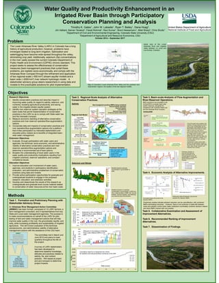
- 1. Water Quality and Productivity Enhancement in an Irrigated River Basin through Participatory Conservation Planning and Analysis Timothy K. Gates1, John W. Labadie1, Ryan T. Bailey1, Dana Hoag2, Jim Valliant, Saman Tavakoli1, Faizal Rohmat1, Ravi Kumar1, Brent Heesemann1, Misti Sharp2, Chris Shultz1 1Department of Civil and Environmental Engineering, Colorado State University (CSU) 2Department of Agricultural and Resource Economics, CSU October 2014 – September 2017 Objectives RVL V B The Lower Arkansas River Valley (LARV) in Colorado has a long history of agricultural production; however, problems have immerged related to long-term irrigation. Salinization and waterlogging have become wide-spread throughout the valley, diminishing crop yield. Additionally, selenium (Se) concentrations in the river vastly exceed the current Colorado Department of Public Health and Environment (CDPHE) chronic standard. This project seeks to assess the effectiveness of conservation measures (best management practices) that curtail these problems, are realistic socio-economically, and comply with the Arkansas River Compact through the refinement and application of two regional-scale (~500 km2) stream-aquifer models and a basin wide (~2000 km2) river network hydrologic model. A stakeholder advisory group steers researchers in using data and models to find practicable solutions for pilot implementation. Problem Research Objectives 1. Identify conservation practices and describe impact in improving water quality (in regard to salinity, selenium, and nutrients), boosting agricultural productivity, and saving water in the irrigated stream-aquifer system. 2. Identify river-reservoir system operation strategies at the basin-scale that permit implementation of conservation practices in the LARV so as to comply with State water law and the interstate Compact. 3. Measure economic standing of alternative conservation practices and river-reservoir operation/flow augmentation options. 4. Incorporate data and impacts of conservation practices and river operation/flow augmentation options into a platform that invites participation by interested stakeholders and educates policy makers as to benefits of integrated basin- wide water management. Extension Objectives 1. Evaluate, through participation with water users and agencies, the technical, socio-economic, and administrative viability of alternative conservation practices and river- reservoir operation/flow augmentation options and determine a recommended set of best options. 2. Broaden the understanding of local water users in the water quality and productivity implications resulting from irrigation practices, reservoir operations, and compact compliance issues. Education Objectives 1. Improve education and involvement of water users, agencies, and students in participatory identification, evaluation, and administrative enablement of conservation practices using data and models. 2. Provide active participation opportunities for graduate and undergraduate students to engage in the proposed research, education, and extension activities. 3. Develop and disseminate the results of this research as undergraduate and graduate level course material related to conservation of water resources at the river basin scale. Task 2. Regional-Scale Analysis of Alternative Conservation Practices. Salinity Selenium and Nitrate Task 3. Basin-scale Analysis of Flow Augmentation and River-Reservoir Operations. Task 4. Economic Analysis of Alternative Improvements. Task 5. Collaborative Examination and Assessment of Improvement Alternatives. Task 6. Recommended Ranking of Improvement Alternatives. Task 7. Dissemination of Findings. Downstream Study Region (DSR) Upstream Study Region (USR) Map of Colorado’s Lower Arkansas River Valley and the upstream and downstream regions, the location of the two regional models. Aerial view of the Lower Arkansas River and irrigated valley between La Junta and Las Animas, Colorado. Methods Task 1. Formation and Preliminary Planning with Stakeholder Advisory Group. An Arkansas River Management Action Committee (ARMAC) has been formed, composed of 12 LARV farmers, a farm management consultant, and 9 representatives from key State and Local water management agencies. The purpose is to make recommendations on behalf of the LARV for pilot testing of land and water management actions that will help improve water quality in the river, the groundwater aquifer, and soils, while increasing profitability and sustainability of irrigated agriculture. This will involve evaluation of the technical, socioeconomic, and administrative viability of alternative management actions with the assistance of the CSU team. Input Data • Soil & landscape properties • Aquifer properties • Crop properties • Canal and irrigation rates & concentrations • Climatic data MODFLOW-UZF Sat-unsat flow model UZF-RT3D Sat-unsat transport model • Advection • Dispersion • Kinetic Reactions • Plant uptake • Auto-and hetero- trophic redox reactions Equilibrium Chemical Reaction Model - Precipitation & Dissolution - Ion Exchange - Complexation - pH, temp effects Predicted Variables - Sat-unsat water content - Soil and aquifer salt concentration - Relative crop yield - Salt load to river The committee met in March and June 2015 and plans to meet quarterly throughout the life of the project. A survey of LARV stakeholders has been developed to determine baseline knowledge, attitudes and practices related to salinity, Se, and nutrient pollution. Will repeat at project end and compare to determine project impacts. ARMAC Propose Solutions Request Research Review Research Discuss/Debate Implications Develop Action Plan Adopt Best Solution CSU Collect Data Build Models Evaluate Solutions Evaluate Impacts Present to ARMAC Revise and Repeat 0 10000 20000 30000 40000 50000 60000 0 5 10 15 20 25 30 35 40 Se(kg) Time (years) Cumulative mass flux of dissolved Se in River for baseline and reduced fertilizer scenarios in the USR Baseline RF 10% RF 20% RF 30% Regional Salt Model Best management practices (BMPs) being considered Reduced fertilizer application Reduced irrigation Land fallowing Reduced canal sealing Enhanced riparian buffer zones Best management practices (BMPs) being considered Reduced fertilizer application Reduced irrigation Land fallowing Reduced canal sealing Enhanced riparian buffer zones Salts, NO3,SeO4 S ET Upflux Irrigation Seepage Se NO3 Salts, NO3, SeO4 Geo-referenced display and interactive scenario manager Administrative and surface water network modeling Surface water – Groundwater model coupling Groundwater model Spatiotemporal Database NHD Plus database CDWR water rights USGS, NWS, EPA, NRCS CSU field data Scenario Manager Historical baseline analysis BMP scenario analysis Interactive basin-wide management model GIS Geo-referenced map display Feature selection tool GeoMODSIM Geo-referenced surface water modeling Accounts for water rights, storage accounts, exchanges, reservoir operations, and Arkansas River Compact MATLAB-ANN Stream-aquifer interaction Input: GIS-processed explanatory variables Output: MODFLOW-UZF return flow predictions MODFLOW-UZF Regional scale 3D numerical groundwater model Developed for large part of the Lower Arkansas River Basin Core of the basin-wide modeling is the coupling of the geo-referenced surface water model (GeoMODSIM) and the groundwater model (MODFLOW-UZF) using Artificial Neural Network (ANN). ANN is a learning model used to approximate functions that can depend on a large number of inputs. In this case, ANN used to approximate MODFLOW-UZF return flow using GIS- processed explanatory variables, (e.g., river flow, canal diversion, pumping, crop distribution). GeoMODSIM models surface water network and administrative aspects of the network flow, including water rights, winter water storage program, and Arkansas River Compact. BMP scenarios to be simulated in the ArkGeoDSS to evaluate basin-wide system response, alongside the compliance with Colorado Water Law and the Arkansas River Compact. ArkGeoDSS SeO4 SO4 Water Table Irrigation Water Salts, NO3,SeO4 Fertilizer NH4 Salts, NO3,SeO4 Root Processes Crop Yield Response Model Modeled baseline selenate concentration in groundwater in DSR. Modeled reduction in selenate concentration in groundwater in DSR from 38-yr implementation of BMP with reduced fertilizer, reduced irrigation, land fallowing, and reduced canal concentration. Reduction in Se loading to Arkansas River under different BMPs in the USR Reduction in NO3-N loading to Arkansas River under different BMPs in the USR Preliminary indication of improved total dissolved solids concentration at the Colorado-Kansas border with selected BMPs, in compliance with the Arkansas River Compact. -$140.00 -$120.00 -$100.00 -$80.00 -$60.00 -$40.00 -$20.00 $0.00 $20.00 -10 0 10 20 30 40 50 Cost,Millionsof$ Selenium Mass Reduction, % Reduced Fertilizer (RF) Canal Sealing (CS) Reduced Irrigation (RI) Leasing Fallowing (LF) Combination: LF, CS, RF Combination: RI, CS, RF Conceptual trade-off curves for Se reduction BMPs. Preliminary trade-off between cost and Se reduction for selected BMPs. Preliminary studies indicate pollutant reduction can be cost-effective, with combined BMPs dominating outcomes . However, there is not continuity in trade-offs between costs and pollution control when water institutions inordinately constrain decision makers and when BMPs interact with one another.