

Recomendados
Recomendados
Más contenido relacionado
La actualidad más candente
La actualidad más candente (13)
Destacado
Destacado (6)
Similar a Gr nr-oct-19-2011
Similar a Gr nr-oct-19-2011 (20)
Más de Christopher R Anderson
Más de Christopher R Anderson (20)
Último
Último (19)
Gr nr-oct-19-2011
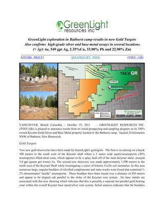
- 1. GreenLight exploration in Bathurst camp results in new Gold Targets Also confirms high-grade silver and base metal assays in several locations. (> 3g/t Au, 549 gpt Ag, 2.35%Cu, 33.90% Pb and 22.90% Zn) ___________________________________________________________________________________ (OTCBB: PRZCF) (FRANKFURT: PHO) (TSXV : GR) VANCOUVER, British Columbia – October 19, 2011 – GREENLIGHT RESOURCES INC. (TSXV.GR), is pleased to announce results from its initial prospecting and sampling program on its 100% owned Keymet Gold Silver and Base Metal property located in the Bathurst camp, located 24 kilometres NNW of Bathurst, New Brunswick. Gold Targets Two new gold discoveries have been made by GreenLight's geologists. The first is in outcrop on a brook 300 meters to the south west of the Keymet shaft where a 2 meter wide quartz-arsenopyrite (20% arsenopyrite) filled shear zone, which appears to be a splay fault off of the main Keymet shear, assayed 3.4 gpt (grams per tonne) Au. The second new discovery was made approximately 1,500 meters to the north west of the Keymet Shaft while investigating a series of historic Cu/Zn soil anomalies. In this area numerous large, angular boulders of silicified conglomerate and meta-wacke were found that contained 1- 2% disseminated “needle” arsenopyrite. These boulders have been traced over a distance of 450 meters and appear to be aligned sub parallel to the strike of the Keymet vein system. No base metals are associated with this new showing which indicates that this is possibly a separate but parallel gold bearing zone within the overall Keymet base metal/silver vein system. Initial analysis indicates that the boulders
- 2. run between 1.7 gpt and >3 gpt Au. (Final analysis on this sample are pending as it was over range and had to be re-analysed.) Silver and Base Metal Targets The Keymet Silver Project covers 6,400 acres and is named after a small past producing mine located on the property. The Keymet area first came to note in 1909 with the discovery of a 6.7meters wide quartz- carbonate-sulphide vein (galena, sphalerite, chalcopyrite, pyrite, arsenopyrite). In 1948 it was announced that the vein was drilled to 137 meters in depth with an average 2.4 meters in width and traceable over a strike length of 341 meters. Assays from surface exposure gave 4.2 meters of 8.48%Pb, 10.99%Zn, and 2.96opt (ounces per ton) Ag. In 1950 a shaft was sunk to the 274 meter level with drifts established on the 45, 91, and 137 meter levels. Production commenced in 1954 and by 1956, the shaft was down to the 366meter level. Production ceased in 1956 when a fire destroyed the mine buildings. A total of 56,000 tons @ 0.25% Cu, 2.44%Pb, 2.59% Zn and 0.99 opt Ag was produced between 1954 and 1956. The Company's geologists have recently taken grab samples from the dump rock at the Keymet shaft and a typical Pb/Zn sample from the ore dump ran 549 gpt Ag, 2.35%Cu, 33.90%Pb and 22.90%Zn. A specimen of massive pyrite with stringer chalcopyrite, galena, spalerite and arsenopyriteassayed 415 gpt Ag, 4.22% Cu, 1.23% Pb, and 1.48% Zn. Currently, a 3D model of the underground workings is being put together based on historic level plans and sections. The area is underlain by a series of sedimentary units consisting of northeast trending greywacke, conglomerate, and interbedded units of pyritic argillite, siltstone and limestone/skarn. Based on historic geophysical and geochemical data, there is good evidence that a series of three and possibly four, parallel vein systems occur on the property. These are the North, Central, Keymet, and South veins. The North vein, which lies approximately 500 meters to the northeast of the Keymet Vein, has been identified over a strike length of 2400 meters by trenching on the southeast and drilling on the northwest. Grab samples taken at the discovery trench in 1989 assayed 57.5%Pb, 6.12% Zn and 20.5 opt Ag. Drilling on the northwest extension in 1965 hit 2 narrow veins which assayed 0.53% Cu, 4.48% Pb, 3.70% Zn and 1.7 opt Ag over 0.4 meters and 7.72%Cu, 0.49%Pb, 11.37%Zn, 13.62 opt Ag over 0.9 meters. Soil geochemistry indicates that this vein(s) is traceable over a strike length of at least 1,585 meters. The Central vein system, 250 meters north of the Keyment vein, has been drilled at three locations outside of the mine area. The first is 850 meters northwest of the Keymet mine whereas single hole intersected a narrow vein within a wide zone of silicification and bleaching that ran 0.64%Cu, 14.6%Pb, 5.6%Zn, 5.1 opt Ag over 0.15 meters. Additional drilling 500 meters further to the northwest intersected the same alteration zone which ran 0.15%Cu, 3.68%Pb, 2.02%Zn and 3.68 opt Ag over 3.5 meters. Drilling carried out in 1965, located a further 1,000 meters northwest hit a number of narrow vein systems ranging from 0.15 meters of 4.14%Cu, 15.6%Pb, 17.8%Zn, 4.2 opt Ag to 1.2 meters of 15.9%Cu, 0.91%Pb, 9.95%Zn and 30.91 opt Ag. As with the North vein system, soil geochemistry indicates that the Keymet vein is traceable for a total of 2,400 meters. This is confirmed by airborne EM and IP. The Keymet vein has been traced by drilling (1947-1952) with wide spaced holes over a distance of 2,400 feet from the shaft area and continues for a further 1,600 feet to the "Old Silver Mine" vein. This vein was
- 3. discovered in 1882 at which time reports indicated grab sample assays of 71.1% Pb, 33.75 opt Ag and 1.28 opt Au. Sometime around 1909 a shaft was sunk to a depth of 20.1 meters and a drift put in along the vein. No further development was recorded. Assays of the vein were taken on the exposure in the bed of the Elmtree River at this time and reports indicate a grade of 7.20 opt Ag over 2.1 meters. Samples from outcrop and float taken by GreenLight's geologistat the Old Silver Mine ran up to 139 gpt Ag, 1.51%Cu, 6.27%Pb and 3.26%Zn including one sample of the outcrop that assayed 14.5%Zn. This showing has never been drilled. The South vein system is located 650 meters southwest of the Keymet Vein and is defined by two showings and soil geochemistry over a strike length of 1,900 meters. The eastern occurrence is described as a series of veins and breccias carrying galena and sphalerite. Drilling was carried out in 1970 and the best intersection was 3 feet of 13% combined Pb/Zn and 1.8 opt Ag. Nineteen hundred meters to the northwest, grab samples taken in the early 1960’s ran as high as 0.5%Cu, 5.85%Pb, 7.41%Zn and 4.52 opt Ag. Readers are warned that "historical records" referred to in this release have been examined but not verified by a "Qualified Person". Further work is required to verify that the historical assays referred to in this release are accurate. Related deposits The Keymet shaft is located 6 km north east of the Castle Resources Ltd (under option from StrataboundMinerals ) Elmtree gold/silver/base metal deposit. A Preliminary Economic Assessment has been completed on an open pit, 1.117 million tonne deposit grading 2.41 gpt Au (with Ag+Pb+Zn credits) deposit and Castle Resources Ltd. is currently engaged in an ongoing Feasibility study prior to moving on to the Environmental Assessment stage. Like Keymet, this deposit is a shear controlled vein system developed in hydrothermally altered sediments either in splay faults to or within the main NNE trending regional shear zones. It should be noted that Castle's Discovery Zone portion of the Elmtree deposit lies within 600 meters of the claim boundary between GreenLight and Castle and is open towards GreenLight's western boundary. At least five areas of similar mineralization to the Elmtree deposit are known to occur on the GreenLight property. These include unexplored historic Au and base metal soil geochemical anomalies and bedrock Au occurrences that have yet to be investigated by GreenLight. Future Exploration Plans Exploration planned for the Keymet claim group will include re-establishment of the geochemical and geophysical grids and locating the historic anomalies on the ground. At the present time, several promising target areas are evident. Both new gold discoveries need to be expanded upon. The brook showing is a drillable target and the Au-conglomerate target requires trenching, with drilling to follow upon a positive outcome to the trenching work. The Keymet vein system was traced for 2400 feet to the northwest of the shaft in the late 40’s, early 50’s but has not been explored since that time. The Old Silver Mine ,4000 feet to the NW has not been
- 4. drilled, even though strong base metal and silver mineralization is evident in outcrop and in the dump rock. Each of the above noted vein systems has untested soil geochemistry and geophysical anomalies that merit drill testing. An estimated 2200 to 2500 meters of drilling will be required to get an initial evaluation of the mineral potential of this portion of the claim group. Patrick Forseille, P. Geo., a Qualified Person as defined by NI 43-101 is responsible for the technical information contained in this release. On Behalf of the board of directors “Chris Anderson” Christopher R Anderson, CEO – President Investor Relations John Curle Email: IR@GreenLightResources.com Read about GreenLight Resources Inc.: http://greenlightresources.com/corporate-overview/ Read Disclaimer: http://greenlightresources.com/legal-disclaimer/ Facebook: http://facebook.com/GreenLightResources | Twitter: @GreenLightRes | Myspace: http://myspace.com/518719311 Suite 888 – 888 Dunsmuir Street Vancouver, B.C., V6C 3K4