SlideShare una empresa de Scribd logo
1 de 17
What is TOPOGRAPHY?
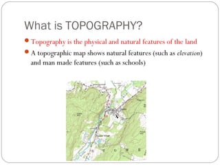
Topography is the physical and natural features of the land
A topographic map shows natural features (such as elevation)
and man made features (such as schools)
Contour Lines
The squiggly lines on a topographic map are called contour
lines
Contour lines are lines that represent a certain height or
elevation
All points on a contour lines are the same elevation
Contour Lines and Elevation
Imagine a picture of a
mountain and then imagine
there were lines drawn around
it every 20 feet
What would the mountain
with the lines look like if you
stood on the side of it?
What would the mountain
with the lines look like if you
were looking down on it from
an airplane?
Contour Lines and Elevation
The closer the contour lines are to each other, the steeper
the slope is!
Other Topographic Terms
Map scale – compares distances on the map with distances on
earth.
Legend – explains symbols used on the map.
Index contours – contour lines that are labeled to help you
find the contour interval.
Relief – the difference in elevation between any 2 points
A contour interval is the difference in elevation between two
contour lines that are side by side.
Remember that a contour interval is not the distance
between the two lines – to get the distance you need to use
the map scale.
Answer the Following…
Circle the map scale
Is there a legend?
Circle at least one
index contour
What is the contour
interval?
Mountains
Mountains are represented by a series of circles
This is a top down view
Depressions
A depression, such as the inside of a dead volcano, is
represented by Hachure lines.
Hachure lines are regular contour lines with small segments
sticking out from it.
The first hachure line is at the same elevation as the contour
line before it.
Streams
Streams are found in areas of low elevation
Streams are sometimes represented by a dark line
Contour lines form Vs that point upstream (toward higher
elevation)
The Vs point in the
opposite direction that
the water flows
Answer the Following….
What letter represents the
stream?
What type of elevation is
here?
Which way is the water
moving: to the right or to
the left?
Topographic Symbols
Mappers, also called cartographers use symbols to represent
certain things on a topographic map
For example, the color green represents an area with lots of
trees or vegetation
Topographic Symbols
Red is used to show a road, highway or interstate
Topographic Symbols
Buildings are usually shown as little black squares
What landforms can be shown on a
topographic map?
Canyons – deep valleys with steep sides, often with streams
flowing through
River deltas – “end” of a river, where the river enters a
larger body of water
Mountains or hills – high elevation
Valleys/depressions – low elevation
Ridges – long, narrow elevation or chain of mountains
What’s happening here?
Which direction has higher elevation?
How do you know?
What’s happening here?
Is this steeper or more gradual than
the last slide? How can you tell?
Which direction has higher elevation?
What’s happening here?
Mountain or valley? How
can you tell?

Más contenido relacionado

La actualidad más candente

Elements of weather and climate
Elements of weather and climateElements of weather and climate
Elements of weather and climateAbdul Rab
 
Geography Skills: Scale
Geography Skills:  ScaleGeography Skills:  Scale
Geography Skills: ScaleTim Bonnar
 
climate and its types
climate and its typesclimate and its types
climate and its typessahil saifi
 
Plate Tectonics
Plate TectonicsPlate Tectonics
Plate Tectonicskmacdevitt
 
Landforms and Landscapes
Landforms and LandscapesLandforms and Landscapes
Landforms and LandscapesMr Shipp
 
Plate tectonics slides re
Plate tectonics slides   rePlate tectonics slides   re
Plate tectonics slides reltanigawa
 
Internal structure of the earth
Internal structure of the earthInternal structure of the earth
Internal structure of the earthJahangir Alam
 
Reading a topographic map
Reading a topographic mapReading a topographic map
Reading a topographic mapRachael Hubbard
 
Major features of earth's surface
Major features of earth's surfaceMajor features of earth's surface
Major features of earth's surfaceJahangir Alam
 
8th grade Geography - Chapter 1
8th grade   Geography - Chapter 18th grade   Geography - Chapter 1
8th grade Geography - Chapter 1Kimberly Ann
 
Climate Factors Ppt
Climate Factors PptClimate Factors Ppt
Climate Factors PptRoseenglobal
 

La actualidad más candente (20)

Elements of weather and climate
Elements of weather and climateElements of weather and climate
Elements of weather and climate
 
Geography Skills: Scale
Geography Skills:  ScaleGeography Skills:  Scale
Geography Skills: Scale
 
climate and its types
climate and its typesclimate and its types
climate and its types
 
CLIMATIC ZONES
CLIMATIC ZONESCLIMATIC ZONES
CLIMATIC ZONES
 
Plate Tectonics
Plate TectonicsPlate Tectonics
Plate Tectonics
 
Landforms and Landscapes
Landforms and LandscapesLandforms and Landscapes
Landforms and Landscapes
 
Climatology
ClimatologyClimatology
Climatology
 
Plate tectonics slides re
Plate tectonics slides   rePlate tectonics slides   re
Plate tectonics slides re
 
Types of Map Scales
Types of Map ScalesTypes of Map Scales
Types of Map Scales
 
Contour lines
Contour linesContour lines
Contour lines
 
Internal structure of the earth
Internal structure of the earthInternal structure of the earth
Internal structure of the earth
 
Maps Ppt
Maps PptMaps Ppt
Maps Ppt
 
ppt weathering
ppt weatheringppt weathering
ppt weathering
 
Reading a topographic map
Reading a topographic mapReading a topographic map
Reading a topographic map
 
Landforms
LandformsLandforms
Landforms
 
Rock Types
Rock TypesRock Types
Rock Types
 
Major features of earth's surface
Major features of earth's surfaceMajor features of earth's surface
Major features of earth's surface
 
Basic coordinate system
Basic coordinate systemBasic coordinate system
Basic coordinate system
 
8th grade Geography - Chapter 1
8th grade   Geography - Chapter 18th grade   Geography - Chapter 1
8th grade Geography - Chapter 1
 
Climate Factors Ppt
Climate Factors PptClimate Factors Ppt
Climate Factors Ppt
 

Destacado

Ocean currents ppt cscope
Ocean currents ppt cscopeOcean currents ppt cscope
Ocean currents ppt cscopeJenny Dixon
 
Factors affecting the climate
Factors affecting the climateFactors affecting the climate
Factors affecting the climatenhojyer sigz
 
Climate and Ocean Currents
Climate and Ocean CurrentsClimate and Ocean Currents
Climate and Ocean Currentsdwinter1
 
2 - Factors Influencing Climate (Summary)
2 - Factors Influencing Climate (Summary)2 - Factors Influencing Climate (Summary)
2 - Factors Influencing Climate (Summary)Ecumene
 
Oceans And Climate
Oceans And ClimateOceans And Climate
Oceans And ClimateTerri Kelsey
 

Destacado (7)

What is Topography
What is TopographyWhat is Topography
What is Topography
 
Ocean currents ppt cscope
Ocean currents ppt cscopeOcean currents ppt cscope
Ocean currents ppt cscope
 
Factors affecting the climate
Factors affecting the climateFactors affecting the climate
Factors affecting the climate
 
Climate and Ocean Currents
Climate and Ocean CurrentsClimate and Ocean Currents
Climate and Ocean Currents
 
2 - Factors Influencing Climate (Summary)
2 - Factors Influencing Climate (Summary)2 - Factors Influencing Climate (Summary)
2 - Factors Influencing Climate (Summary)
 
Oceans And Climate
Oceans And ClimateOceans And Climate
Oceans And Climate
 
Climate powerpoint
Climate powerpointClimate powerpoint
Climate powerpoint
 

Similar a Topography powerpoint

Topographic maps for UDL lesson
Topographic maps for UDL lessonTopographic maps for UDL lesson
Topographic maps for UDL lessonrbritton24
 
Topographic maps for UDL lesson
Topographic maps for UDL lessonTopographic maps for UDL lesson
Topographic maps for UDL lessonrbritton24
 
12 s080702 e_topography-1
12 s080702 e_topography-112 s080702 e_topography-1
12 s080702 e_topography-1Jenny Dixon
 
Topographic maps
Topographic mapsTopographic maps
Topographic mapsllaub
 
Basic topographic mapping
Basic topographic mappingBasic topographic mapping
Basic topographic mappingBhok Millare
 
Maps-and-map-interpretation.docx
Maps-and-map-interpretation.docxMaps-and-map-interpretation.docx
Maps-and-map-interpretation.docxshucaybcabdi
 
Land Navigation Presentation
Land Navigation PresentationLand Navigation Presentation
Land Navigation PresentationWilliam Perkins
 
Social Science Unit 1 Our World presentation
Social Science Unit 1 Our World presentationSocial Science Unit 1 Our World presentation
Social Science Unit 1 Our World presentationBlanca Francisco Tardón
 
topographicmapsnotes-130930200052-phpapp01.pdf
topographicmapsnotes-130930200052-phpapp01.pdftopographicmapsnotes-130930200052-phpapp01.pdf
topographicmapsnotes-130930200052-phpapp01.pdfshucaybcabdi
 
BOLTSS - Mapping Geography
BOLTSS - Mapping GeographyBOLTSS - Mapping Geography
BOLTSS - Mapping GeographyYaryalitsa
 
Lesson 12 intro to topo
Lesson 12 intro to topoLesson 12 intro to topo
Lesson 12 intro to topojakelederman
 
Isolines and contour lines
Isolines and contour linesIsolines and contour lines
Isolines and contour lineslschmidt1170
 
Topo and satellite views notes
Topo and satellite views notesTopo and satellite views notes
Topo and satellite views notese045911
 
Chapt02 lecture getis 13e
Chapt02 lecture getis 13eChapt02 lecture getis 13e
Chapt02 lecture getis 13eadanovi
 

Similar a Topography powerpoint (20)

Topographic maps
Topographic mapsTopographic maps
Topographic maps
 
Mapping
MappingMapping
Mapping
 
Topographic maps for UDL lesson
Topographic maps for UDL lessonTopographic maps for UDL lesson
Topographic maps for UDL lesson
 
Topographic maps for UDL lesson
Topographic maps for UDL lessonTopographic maps for UDL lesson
Topographic maps for UDL lesson
 
Topo maps
Topo mapsTopo maps
Topo maps
 
12 s080702 e_topography-1
12 s080702 e_topography-112 s080702 e_topography-1
12 s080702 e_topography-1
 
Topographic maps
Topographic mapsTopographic maps
Topographic maps
 
Toposheet interpretation
Toposheet interpretationToposheet interpretation
Toposheet interpretation
 
Basic topographic mapping
Basic topographic mappingBasic topographic mapping
Basic topographic mapping
 
Maps-and-map-interpretation.docx
Maps-and-map-interpretation.docxMaps-and-map-interpretation.docx
Maps-and-map-interpretation.docx
 
Unit 2 Elements of a map.pdf
Unit 2 Elements of a map.pdfUnit 2 Elements of a map.pdf
Unit 2 Elements of a map.pdf
 
Land Navigation Presentation
Land Navigation PresentationLand Navigation Presentation
Land Navigation Presentation
 
Social Science Unit 1 Our World presentation
Social Science Unit 1 Our World presentationSocial Science Unit 1 Our World presentation
Social Science Unit 1 Our World presentation
 
Mapwork
MapworkMapwork
Mapwork
 
topographicmapsnotes-130930200052-phpapp01.pdf
topographicmapsnotes-130930200052-phpapp01.pdftopographicmapsnotes-130930200052-phpapp01.pdf
topographicmapsnotes-130930200052-phpapp01.pdf
 
BOLTSS - Mapping Geography
BOLTSS - Mapping GeographyBOLTSS - Mapping Geography
BOLTSS - Mapping Geography
 
Lesson 12 intro to topo
Lesson 12 intro to topoLesson 12 intro to topo
Lesson 12 intro to topo
 
Isolines and contour lines
Isolines and contour linesIsolines and contour lines
Isolines and contour lines
 
Topo and satellite views notes
Topo and satellite views notesTopo and satellite views notes
Topo and satellite views notes
 
Chapt02 lecture getis 13e
Chapt02 lecture getis 13eChapt02 lecture getis 13e
Chapt02 lecture getis 13e
 

Último

Full Stack Web Development Course for Beginners
Full Stack Web Development Course  for BeginnersFull Stack Web Development Course  for Beginners
Full Stack Web Development Course for BeginnersSabitha Banu
 
Activity 2-unit 2-update 2024. English translation
Activity 2-unit 2-update 2024. English translationActivity 2-unit 2-update 2024. English translation
Activity 2-unit 2-update 2024. English translationRosabel UA
 
Choosing the Right CBSE School A Comprehensive Guide for Parents
Choosing the Right CBSE School A Comprehensive Guide for ParentsChoosing the Right CBSE School A Comprehensive Guide for Parents
Choosing the Right CBSE School A Comprehensive Guide for Parentsnavabharathschool99
 
Karra SKD Conference Presentation Revised.pptx
Karra SKD Conference Presentation Revised.pptxKarra SKD Conference Presentation Revised.pptx
Karra SKD Conference Presentation Revised.pptxAshokKarra1
 
AUDIENCE THEORY -CULTIVATION THEORY - GERBNER.pptx
AUDIENCE THEORY -CULTIVATION THEORY -  GERBNER.pptxAUDIENCE THEORY -CULTIVATION THEORY -  GERBNER.pptx
AUDIENCE THEORY -CULTIVATION THEORY - GERBNER.pptxiammrhaywood
 
Global Lehigh Strategic Initiatives (without descriptions)
Global Lehigh Strategic Initiatives (without descriptions)Global Lehigh Strategic Initiatives (without descriptions)
Global Lehigh Strategic Initiatives (without descriptions)cama23
 
ENGLISH 7_Q4_LESSON 2_ Employing a Variety of Strategies for Effective Interp...
ENGLISH 7_Q4_LESSON 2_ Employing a Variety of Strategies for Effective Interp...ENGLISH 7_Q4_LESSON 2_ Employing a Variety of Strategies for Effective Interp...
ENGLISH 7_Q4_LESSON 2_ Employing a Variety of Strategies for Effective Interp...JhezDiaz1
 
Inclusivity Essentials_ Creating Accessible Websites for Nonprofits .pdf
Inclusivity Essentials_ Creating Accessible Websites for Nonprofits .pdfInclusivity Essentials_ Creating Accessible Websites for Nonprofits .pdf
Inclusivity Essentials_ Creating Accessible Websites for Nonprofits .pdfTechSoup
 
Q4-PPT-Music9_Lesson-1-Romantic-Opera.pptx
Q4-PPT-Music9_Lesson-1-Romantic-Opera.pptxQ4-PPT-Music9_Lesson-1-Romantic-Opera.pptx
Q4-PPT-Music9_Lesson-1-Romantic-Opera.pptxlancelewisportillo
 
INTRODUCTION TO CATHOLIC CHRISTOLOGY.pptx
INTRODUCTION TO CATHOLIC CHRISTOLOGY.pptxINTRODUCTION TO CATHOLIC CHRISTOLOGY.pptx
INTRODUCTION TO CATHOLIC CHRISTOLOGY.pptxHumphrey A Beña
 
Active Learning Strategies (in short ALS).pdf
Active Learning Strategies (in short ALS).pdfActive Learning Strategies (in short ALS).pdf
Active Learning Strategies (in short ALS).pdfPatidar M
 
USPS® Forced Meter Migration - How to Know if Your Postage Meter Will Soon be...
USPS® Forced Meter Migration - How to Know if Your Postage Meter Will Soon be...USPS® Forced Meter Migration - How to Know if Your Postage Meter Will Soon be...
USPS® Forced Meter Migration - How to Know if Your Postage Meter Will Soon be...Postal Advocate Inc.
 
Concurrency Control in Database Management system
Concurrency Control in Database Management systemConcurrency Control in Database Management system
Concurrency Control in Database Management systemChristalin Nelson
 
What is Model Inheritance in Odoo 17 ERP
What is Model Inheritance in Odoo 17 ERPWhat is Model Inheritance in Odoo 17 ERP
What is Model Inheritance in Odoo 17 ERPCeline George
 
4.18.24 Movement Legacies, Reflection, and Review.pptx
4.18.24 Movement Legacies, Reflection, and Review.pptx4.18.24 Movement Legacies, Reflection, and Review.pptx
4.18.24 Movement Legacies, Reflection, and Review.pptxmary850239
 
Influencing policy (training slides from Fast Track Impact)
Influencing policy (training slides from Fast Track Impact)Influencing policy (training slides from Fast Track Impact)
Influencing policy (training slides from Fast Track Impact)Mark Reed
 
Barangay Council for the Protection of Children (BCPC) Orientation.pptx
Barangay Council for the Protection of Children (BCPC) Orientation.pptxBarangay Council for the Protection of Children (BCPC) Orientation.pptx
Barangay Council for the Protection of Children (BCPC) Orientation.pptxCarlos105
 

Último (20)

Full Stack Web Development Course for Beginners
Full Stack Web Development Course  for BeginnersFull Stack Web Development Course  for Beginners
Full Stack Web Development Course for Beginners
 
Activity 2-unit 2-update 2024. English translation
Activity 2-unit 2-update 2024. English translationActivity 2-unit 2-update 2024. English translation
Activity 2-unit 2-update 2024. English translation
 
Choosing the Right CBSE School A Comprehensive Guide for Parents
Choosing the Right CBSE School A Comprehensive Guide for ParentsChoosing the Right CBSE School A Comprehensive Guide for Parents
Choosing the Right CBSE School A Comprehensive Guide for Parents
 
Raw materials used in Herbal Cosmetics.pptx
Raw materials used in Herbal Cosmetics.pptxRaw materials used in Herbal Cosmetics.pptx
Raw materials used in Herbal Cosmetics.pptx
 
Karra SKD Conference Presentation Revised.pptx
Karra SKD Conference Presentation Revised.pptxKarra SKD Conference Presentation Revised.pptx
Karra SKD Conference Presentation Revised.pptx
 
FINALS_OF_LEFT_ON_C'N_EL_DORADO_2024.pptx
FINALS_OF_LEFT_ON_C'N_EL_DORADO_2024.pptxFINALS_OF_LEFT_ON_C'N_EL_DORADO_2024.pptx
FINALS_OF_LEFT_ON_C'N_EL_DORADO_2024.pptx
 
AUDIENCE THEORY -CULTIVATION THEORY - GERBNER.pptx
AUDIENCE THEORY -CULTIVATION THEORY -  GERBNER.pptxAUDIENCE THEORY -CULTIVATION THEORY -  GERBNER.pptx
AUDIENCE THEORY -CULTIVATION THEORY - GERBNER.pptx
 
Global Lehigh Strategic Initiatives (without descriptions)
Global Lehigh Strategic Initiatives (without descriptions)Global Lehigh Strategic Initiatives (without descriptions)
Global Lehigh Strategic Initiatives (without descriptions)
 
ENGLISH 7_Q4_LESSON 2_ Employing a Variety of Strategies for Effective Interp...
ENGLISH 7_Q4_LESSON 2_ Employing a Variety of Strategies for Effective Interp...ENGLISH 7_Q4_LESSON 2_ Employing a Variety of Strategies for Effective Interp...
ENGLISH 7_Q4_LESSON 2_ Employing a Variety of Strategies for Effective Interp...
 
Inclusivity Essentials_ Creating Accessible Websites for Nonprofits .pdf
Inclusivity Essentials_ Creating Accessible Websites for Nonprofits .pdfInclusivity Essentials_ Creating Accessible Websites for Nonprofits .pdf
Inclusivity Essentials_ Creating Accessible Websites for Nonprofits .pdf
 
YOUVE_GOT_EMAIL_PRELIMS_EL_DORADO_2024.pptx
YOUVE_GOT_EMAIL_PRELIMS_EL_DORADO_2024.pptxYOUVE_GOT_EMAIL_PRELIMS_EL_DORADO_2024.pptx
YOUVE_GOT_EMAIL_PRELIMS_EL_DORADO_2024.pptx
 
Q4-PPT-Music9_Lesson-1-Romantic-Opera.pptx
Q4-PPT-Music9_Lesson-1-Romantic-Opera.pptxQ4-PPT-Music9_Lesson-1-Romantic-Opera.pptx
Q4-PPT-Music9_Lesson-1-Romantic-Opera.pptx
 
INTRODUCTION TO CATHOLIC CHRISTOLOGY.pptx
INTRODUCTION TO CATHOLIC CHRISTOLOGY.pptxINTRODUCTION TO CATHOLIC CHRISTOLOGY.pptx
INTRODUCTION TO CATHOLIC CHRISTOLOGY.pptx
 
Active Learning Strategies (in short ALS).pdf
Active Learning Strategies (in short ALS).pdfActive Learning Strategies (in short ALS).pdf
Active Learning Strategies (in short ALS).pdf
 
USPS® Forced Meter Migration - How to Know if Your Postage Meter Will Soon be...
USPS® Forced Meter Migration - How to Know if Your Postage Meter Will Soon be...USPS® Forced Meter Migration - How to Know if Your Postage Meter Will Soon be...
USPS® Forced Meter Migration - How to Know if Your Postage Meter Will Soon be...
 
Concurrency Control in Database Management system
Concurrency Control in Database Management systemConcurrency Control in Database Management system
Concurrency Control in Database Management system
 
What is Model Inheritance in Odoo 17 ERP
What is Model Inheritance in Odoo 17 ERPWhat is Model Inheritance in Odoo 17 ERP
What is Model Inheritance in Odoo 17 ERP
 
4.18.24 Movement Legacies, Reflection, and Review.pptx
4.18.24 Movement Legacies, Reflection, and Review.pptx4.18.24 Movement Legacies, Reflection, and Review.pptx
4.18.24 Movement Legacies, Reflection, and Review.pptx
 
Influencing policy (training slides from Fast Track Impact)
Influencing policy (training slides from Fast Track Impact)Influencing policy (training slides from Fast Track Impact)
Influencing policy (training slides from Fast Track Impact)
 
Barangay Council for the Protection of Children (BCPC) Orientation.pptx
Barangay Council for the Protection of Children (BCPC) Orientation.pptxBarangay Council for the Protection of Children (BCPC) Orientation.pptx
Barangay Council for the Protection of Children (BCPC) Orientation.pptx
 

Topography powerpoint

  • 1. What is TOPOGRAPHY? Topography is the physical and natural features of the land A topographic map shows natural features (such as elevation) and man made features (such as schools)
  • 2. Contour Lines The squiggly lines on a topographic map are called contour lines Contour lines are lines that represent a certain height or elevation All points on a contour lines are the same elevation
  • 3. Contour Lines and Elevation Imagine a picture of a mountain and then imagine there were lines drawn around it every 20 feet What would the mountain with the lines look like if you stood on the side of it? What would the mountain with the lines look like if you were looking down on it from an airplane?
  • 4. Contour Lines and Elevation The closer the contour lines are to each other, the steeper the slope is!
  • 5. Other Topographic Terms Map scale – compares distances on the map with distances on earth. Legend – explains symbols used on the map. Index contours – contour lines that are labeled to help you find the contour interval. Relief – the difference in elevation between any 2 points A contour interval is the difference in elevation between two contour lines that are side by side. Remember that a contour interval is not the distance between the two lines – to get the distance you need to use the map scale.
  • 6. Answer the Following… Circle the map scale Is there a legend? Circle at least one index contour What is the contour interval?
  • 7. Mountains Mountains are represented by a series of circles This is a top down view
  • 8. Depressions A depression, such as the inside of a dead volcano, is represented by Hachure lines. Hachure lines are regular contour lines with small segments sticking out from it. The first hachure line is at the same elevation as the contour line before it.
  • 9. Streams Streams are found in areas of low elevation Streams are sometimes represented by a dark line Contour lines form Vs that point upstream (toward higher elevation) The Vs point in the opposite direction that the water flows
  • 10. Answer the Following…. What letter represents the stream? What type of elevation is here? Which way is the water moving: to the right or to the left?
  • 11. Topographic Symbols Mappers, also called cartographers use symbols to represent certain things on a topographic map For example, the color green represents an area with lots of trees or vegetation
  • 12. Topographic Symbols Red is used to show a road, highway or interstate
  • 13. Topographic Symbols Buildings are usually shown as little black squares
  • 14. What landforms can be shown on a topographic map? Canyons – deep valleys with steep sides, often with streams flowing through River deltas – “end” of a river, where the river enters a larger body of water Mountains or hills – high elevation Valleys/depressions – low elevation Ridges – long, narrow elevation or chain of mountains
  • 15. What’s happening here? Which direction has higher elevation? How do you know?
  • 16. What’s happening here? Is this steeper or more gradual than the last slide? How can you tell? Which direction has higher elevation?
  • 17. What’s happening here? Mountain or valley? How can you tell?

Notas del editor

  1. Contour lines are spaced far apart, so we know the elevation change is gradual. The “V” shapes suggest the formation of a river, which would be flowing FROM RIGHT TO LEFT. Upstream is to the east, downstream is to the west
  2. Some of the lines are very close, indicating a steep incline. This is likely a canyon, formed by a river that is flowing FROM LEFT TO RIGHT.
  3. This is a mountain – the highest elevation is in the middle (no hachure lines to indicate this is a depression). Likely there is a river flowing westward along the Vs, which seems to be creating a canyon. The southeastern slope is steeper than the northwestern slope.