

Recommended
More Related Content
More from Jessica Villarmente
More from Jessica Villarmente (20)
Recently uploaded
Recently uploaded (20)
Photos set 3
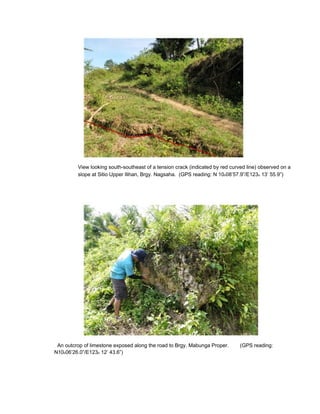
- 1. View looking south-southeast of a tension crack (indicated by red curved line) observed on a slope at Sitio Upper Ilihan, Brgy. Nagsaha. (GPS reading: N 10o08’57.9”/E123o 13’ 55.9”) An outcrop of limestone exposed along the road to Brgy. Mabunga Proper. (GPS reading: N10o06’26.0”/E123o 12’ 43.6”)
- 2. Multiple tension cracks that have developed on a slope at Sitio Bulay, brgy. T-Hill following the March 6, 2012 earthquake. Two houses have reportedly been totally damaged. About five houses located downslope are at high risk to landslide and must be immediately relocated. (GPS reading: N10o06’47.5”/E 123o 13’ 32.7”) Another one of a series of tension cracks at Sitio Bulay approximately 500 meters downhill from the area shown above.
- 3. Another view of the tension cracks (marked red) shown above. Note the translational slide (encircled) located approximately 1 meter below the tension crack. (GPS reading: N10o06’47.0”/E123o 13’ 32.6”) An active landslide affecting a road at Brgy. Nagsaha Proper. (GPS reading: N10o09’10.5”/E123o 13’ 15.2”)
- 4. Panoramic view of numerous landslide escarpments at Sitio Kandaislan, Brgy. T- Hill. (GPS reading: N10o0 A house at Sitio Malabitoon, Brgy. Mabunga that was damaged by landslide following the February 6, 2012 ea N10o07’32.1”/E 123o 13’ 43.5”)
- 5. A huge landslide escarpment at Brgy. Mabunga, viewed from Sitio Malabitoon. (GPS reading: N10o06’31.2”/E 123o 12’ 10.2”) A rockfall that damaged the national road at Sitio Malabuyukon, Brgy. Magsaysay. (GPS reading: N10o08’52.3”/E123o 13’ 55.8”)
- 6. View looking west of a translational slide on a slope bounding Sitio Malinoy, Brgy. Magsaysay. Houses at the footslope are at risk in case the landslide is reactivated. (GPS reading: N10o08’30”/E 123o 12’ 43.1”) Mandi-i Elementary School at Sitio Mandi-i, Magsaysay adjacent to a steep slope. The location of the school makes it highly susceptible to landslide. (GPS reading: N10o09’6.5”/E 123o 11’ 57”)
- 7. These houses along the national road at Sitio Giob, Brgy. Magsaysay are threatened by the presence of huge, loose limestone boulders on steep slopes bounding the area. Removal of these materials is recommended. (GPS reading: N10o09’3.4”/ E123o 12’ 13.9”) View looking northwest of translational slides affecting a slope at Sitio Giob, Brgy. Nagsaha. (GPS reading: N10o09’5.9”/E 123o 12’ 08.8”)
- 8. A recent landslide at Sitio Larena, brgy. Poblacion that damaged 5 houses following the February 6, 2012 earthquake. Settlement near steep slopes is highly (GPS reading: N10o07’40.3”/E 123o 15’ 41.3”)