1. B E S T M A N A G E M E N T P R A C T I C E S � B M P s F O R C R O P L A N D E R O S I O N C O N T R O L 9 7
BMPS FOR CROPLAND EROSION
CONTROL
Properly designed and located erosion control structures can safely convey excess
water to an appropriate outlet. This chapter explains how to verify soil erosion 5.01p
issues, presents different types of erosion control structures and their respective
features and maintenance needs, and shows how to plan for their implementation.
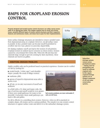
Some surface drainage structures are intended to remove ponded water
from depressional areas on cropland. However, not all surface water
is ponded. In fact, ponded water can become runoff if permitted to
overflow into low runs (draws) in unevenly sloped fields.
On sloping cropland, runoff can lead to the erosion of soil particles.
Cropland erosion in uniform layers is known as sheet erosion. Erosion
caused by concentrated flow forms rills. When the rills develop into
channels large enough to prevent crossing by farm machinery, these
channels are known as gullies.
Subsurface
drainage systems
VERIFyING EROSION PROBLEMS remove excess
gravitational waters
– making room for
Highly erodible soils can be predicted based on practical experience. Erosion can be verified
precipitation and
on-site by looking for:
runoff to infiltrate
� eroded knolls (”white-caps”) and shoulder cropland soils.
slopes (usually the result of tillage erosion) In this regard,
5.02p cropland drainage
� washouts (rills) systems are an
integral component
� aprons of topsoil in depressional areas after a
of soil and water
storm event conservation
� off-site (or on-site) movement of runoff and systems.
sediment.
In a field with a 5% slope and loamy soils, the
rate of soil loss and runoff would be even greater
if there were small pathways for water to run Soil erosion problems are more noticeable if
downhill. Unchecked, these small pathways can soils are left bare.
lead to rills and gullies.
No-till is effective in controlling sheet erosion. However, when no-till is practised on
complex slopes, rill erosion can be a serious problem. The remedy is to use erosion control
structures to capture surface water and deliver it to the subsurface drainage system.
2. 9 8 B E S T M A N A G E M E N T P R A C T I C E S � A G R I C U L T U R A L D R A I N A G E
EROSION CONTROL STRUCTURES
Erosion control structures are designed to both control erosion and safely convey surface
5.03p water to an adequate outlet. Common examples include grassed waterways, terraces, and
water and sediment control basins (WaSCoBs). Some of these systems are designed so that
the rate of water removal has been reduced.
Calibrated standpipe inlets (e.g., Hickenbottom inlets) in WaSCoBs limit sediment loading
from runoff events by allowing the water to pond for a short period of time and soil particles
to settle out before entering the inlet.
Erosion control structures move surface runoff to subsurface drainage systems and, by
strategic placement, limit the erosive forces of runoff events. This type of erosion control
structure includes diversion terraces and narrow-based terraces.
A systems approach is the most effective way to
address cropland runoff and erosion problems. A soil and
water conservation system designed to reduce the risks
of soil loss has the following components:
• cropland erosion control structures
• surface water management
• subsurface drainage
• soil management BMPs, and
• conservation tillage and cropping practices.
Erosion control
structures are
designed and
constructed to convey
overland flow to a 5.04p 5.05p
safe outlet.
4 WaSCoBs are earthen embankments across 4 Grassed waterways are graded and grassed
draws, with retention basins and calibrated riser channels placed in draws with subsurface
pipe inlets (drop-pipe inlets) to convey water drainpipe, intended to divert and transfer
to an adequate pipe outlet. These structures runoff to a properly protected outlet. They work
reduce erosion downslope. The duration of best when established as part of an erosion
temporary ponding is carefully engineered to control system that includes soil conservation
reduce the risk of damaging the crop. Inspect BMPs such as no-till and mulch tillage.
after major storm events and ensure that the
inlet pipe is not blocked by sediment or crop
debris.
3. B E S T M A N A G E M E N T P R A C T I C E S � B M P s F O R C R O P L A N D E R O S I O N C O N T R O L 9 9
5.06p
4 A diversion is a combination of channels and berms placed across slopes (reducing the
grade) to slow down the runoff and reduce erosion. The water is conveyed to a grassed
waterway or to a surface inlet where the water is then carried via an underground
drainpipe to a proper outlet.
4 A large-diameter pipe (drop
pipe) is installed to convey
5.07p
water down steep slopes or
high drops to prevent ponded
water or concentrated flow
from forming large rills or
gullies.
4. 1 0 0 B E S T M A N A G E M E N T P R A C T I C E S � A G R I C U L T U R A L D R A I N A G E
5.08p
4 A rock chute spillway is a constructed chute using angular stone (riprap) and underlain with filter
cloth. Rock chutes are often placed in riparian areas to convey concentrated surface flows safely to
watercourses. As with all erosion control structures, rock chute spillways are most effective when
managed as part of a soil conservation system.
5. B E S T M A N A G E M E N T P R A C T I C E S � B M P s F O R C R O P L A N D E R O S I O N C O N T R O L 1 0 1
EROSION CONTROL STRUCTURES
BMP + DESCRIPTION FUNCTION & DESIGN FEATURES MAINTENANCE & REPAIR
TERRACE • intercepts surface runoff and breaks up a single • monitor in spring and after storm events for
slope-length into shorter lengths breaches in, or erosion of, berms
Earthen berm or ridge • constructed at a suitable lateral grade to an outlet • ensure proper functioning of emergency
across slope • see WASCoB for design considerations spillway
• keep drop-pipe inlets clear of debris
WaSCoB • berm and basin with inlet built across slope to • monitor inlet area for function and condition
divert runoff to subsurface drainpipe • clean debris from inlet to allow for proper
(Water and sediment • settles out some sediment functioning
control basin) • design accounts for watershed size and shape, rate • ensure the integrity of the berm
of runoff, volume of storage, erodibility of soil • keep track of soil sediment buildup and
Small water-detention material, and impacts of cropping and tillage remove when necessary
basins and berm practices on runoff
• works on watersheds up to 20 ha (50 ac)
• basin design is usually sized to hold 15 years of
eroded soil
DIVERSION • constructed across slope to divert water and runoff • monitor in spring and after storm events for
to a position where it can be safely conveyed breaches in, or erosion of, berms
A channel with a • see WASCoB for design considerations • monitor inlet area for function and
supporting ridge on condition
the lower side • clean debris from inlet to allow for proper
functioning
GRASSED WATERWAY • safe transport of runoff from field or erosion control • seed with recommended grass mixture and
structure such as diversions, terrace and fertilize to ensure proper cover
Natural or constructed, strip-cropping to a proper outlet • mow vegetation at least twice per year to
grassed waterway – • works best if part of soil conservation system promote establishment and cover
usually in draw or • has parabolic or trapezoidal cross-sectional shape to • reduce traffic on grassed waterway
between convergent resemble natural channels • don’t create dead furrow along water way
slopes • requires a subsurface pipe underneath to handle – could cause rill beside waterway
low-flow conditions and maintain good hydrologic • respect separation distances to keep
conditions cropland herbicides away from cover
• best suited to grades <5% • can be grazed or hayed if conditions are dry
DROP-PIPE INLET • intercept and carry a concentrated flow of water • monitor pipes and inlet area for function
safely from a higher to a lower elevation and condition
Enclosed vertical pipe • structures of steel, plastic or concrete vertical pipe • clean debris from inlet to allow for proper
structure connected to are usually located near watercourses functioning
subsurface drainpipe • can be used if drop is greater than 1.5 m (5 ft) • replace broken pipe, grates, and constrictors
• design based on peak flow, fall and distance, berm
size and spillway requirements
ROCK CHUTE SPILLWAY • safely conveys fast-flowing channelized water down • monitor for erosion under spillway, shifting
a steep gradient rocks and debris
• works well where water from a grassed waterway • remove debris
enters a drainage channel or stream or in old fence • replace and adjust rocks and filter cloth as
lines where the rate of water flow prevents vegetation needed to prevent scouring
from maintaining cover
• uses entrance and exit aprons to reduce erosion and
to control flow
• large rocks (22 kg (50 lb) are recommended
• anchored filter cloth underneath rock is recommended
6. 1 0 2 B E S T M A N A G E M E N T P R A C T I C E S � A G R I C U L T U R A L D R A I N A G E
PLANNING FOR EROSION CONTROL STRUCTURES
4 Seek technical advice for design and construction from professionals and trained
contractors.
4 Consider the following factors in the planning process:
� future land use – whether the land will remain in its current land use
� slope steepness, slope length, soil type, upslope (in-field) watershed size – must
be considered when designing structures for size and safety
� cropping and tillage practices – how compatible a particular structure would be for
current crop types, field operations
� cost of options – which option provides the most value for the investment required
� potential improvements or changes to downstream water system.
4 To manage concentrated flow and reduce potential risks, you could:
� protect the draw
� reduce the length of eroding section by segmenting into smaller units
� divert the flow below the surface.
In fact, most erosion control structures are designed to attain one or more of these
objectives. For example, WaSCoBs reduce the length of eroding section and divert the flow
below the surface. Multiple units can be installed.
For more on cropland conservation structures,
see the BMP book, Field Crop Production. 5.09p
For more information please see OMAFRA
Publication 832: Agricultural Erosion Control
Structures – A Design and Construction Manual.
7. B E S T M A N A G E M E N T P R A C T I C E S � B M P s F O R S U B S U R F A C E D R A I N A G E 1 0 3
BMPs FOR SUBSURFACE
DRAINAGE
This extensive chapter begins with approaches to identify subsurface drainage issues. Accurate on-site
diagnostics are the first step in planning a subsurface drainage system. Once site conditions are
understood, system design is the next stage, and we will take it step by step. We’ll explain BMPs for
installation – using checklists for both landowners and licensed drainage contractors. As we move to
maintenance and management BMPs, we focus on troubleshooting. The chapter concludes with a look at
emerging technologies.
The main challenges for subsurface drainage are:
• managing crop inputs and other contaminants
• removing excess water but also conserving water
• managing wet areas, and
• protecting adjacent wetlands.
Diagnosing Subsurface Drainage Issues
Conditions That Require Subsurface Drainage
In many cases, cropland drainage systems are established or improved due to the limitations
of local soil and site conditions. Also, we have a humid climate in Ontario, which means
that on average there is a net surplus of water on most croplands. The growing season
(optimum temperatures) is limited and soil needs to be in a good hydrological condition for
the full growing season.
Soils may need subsurface drainage for one or more of the following reasons.
Uneven soil moisture conditions. Soil moisture conditions are not sufficiently uniform for
efficient field operations on fields with highly variable soil types and slope positions.
Inadequate natural drainage for the crop’s sensitivity. Some crops are very sensitive
to water (“wet feet”), and are easily damaged if roots are in saturated soil. Some soils have
average natural drainage, but are unsuitable for the crop’s needs.
Soils with naturally high water tables. Usually found in level-to-depressional
topography or where impermeable subsoils limit water infiltration, these soils will benefit
from systematic subsurface drainage systems. Such soils are referred to as poor and
imperfectly drained soil types on soil maps and reports.
8. 1 0 4 B E S T M A N A G E M E N T P R A C T I C E S � A gricultural D R A I N A G E
Fig. 6A
Soils may need subsurface drainage for one or more of the following reasons.
Uneven soil moisture conditions. Soil moisture conditions are not sufficiently uniform for
efficient field operations on fields with highly variable soil types and slope positions.
Inadequate natural drainage for the crop’s sensitivity. Some crops are very sensitive to
water (“wet feet”), and are easily damaged if roots are in saturated soil. Some soils have
average natural drainage, but are unsuitable for the crop’s needs.
Soils with naturally high water tables. Usually found in level-to-depressional topography or
where impermeable subsoils limit water infiltration, these soils will benefit from systematic
subsurface drainage systems. Such soils are referred to as poor and imperfectly drained soil
types on soil maps and reports.
Fig. 6b
Croplands soils with a
drainage class of poor
require subsurface
drainage. Poorly
drained soils have a
high water table for
most of the year. To
verify poor drainage,
check for a zone of
mottles and gley
colours in the top 50
cm (20 in.) of the soil
profile.
9. B E S T M A N A G E M E N T P R A C T I C E S � B M P s F O R S U B S U R F A C E D R A I N A G E 1 0 5
Water won’t flow to outlet because land is too flat or natural surface barriers limit movement
of water. Such sites are often in depressional areas.
Artificial barriers. Constructed barriers that obstruct or limit the flow of water include roads,
fence rows, dams, dikes, bridges, and culverts of insufficient capacity and depth.
Topographic site position. For want of sufficient land slope, or due to natural surface
barriers, water cannot flow to an oulet. Such sites are often in depressional areas.
Seepage areas. When water table conditions cause groundwater to be discharged on a
sloping field, the soil can be sufficiently saturated to require subsurface drainage. A single
seepage area can render a large area of cropland unfit for crop production.
Fig. 6c
Impermeable soil materials. Soil layers of low permeability that restrict the downward
movement of water trapped in small surface depressions or held in the soil profile may
benefit from subsurface drainage.
10. 1 0 6 B E S T M A N A G E M E N T P R A C T I C E S � A G R I C U L T U R A L D R A I N A G E
FIG. 6D
6.01p
In some cases, subsurface drainpipes are surrounded by impermeable
soils such as heavy clay, pure silts, or compacted subsoils.
Recharge areas do not
require subsurface
drainage.
11. B E S T M A N A G E M E N T P R A C T I C E S � B M P s F O R S U B S U R F A C E D R A I N A G E 1 0 7
Draining Natural Temporarily Ponded Areas on Cropland: A Matter of Need or
Convenience?
Removal of surface water from croplands has many potential benefits. On the other hand, these temporarily
inundated locations, although not permanent wetlands, may provide the water storage functions and habitat
for a variety of plant and wildlife species. Think carefully before you act in these situations.
4 Seriously consider the pros and cons of draining wet areas on cropland.
Questions to consider before draining a wet area:
• What is the size of the wet area?
• How is this area impacting nearby field operations?
• How long does the water stand on the surface?
• On average, how many days does this wet area delay field work in spring?
• On average, how often does this wet area contribute to crop flooding and significant profit loss?
• Does wildlife use this wet area when ponded or at other times during the year?
• Is there wetland vegetation present?
• Is this area immediately adjacent to a designated wetland or riparian area?
• Will this area grow a profitable crop when drained?
• Is a permit required from the Conservation Authority or other agency?
• Is the area a candidate for retiring from production?
• What will the drainage project cost?
By answering each of these questions, you’ll be in a stronger position to assess the significance of this wet
area and its relative importance and potential as cropland.
Visual Identification of Cropland Drainage Problems
Most naturally well-drained cropland soils in Ontario experience a moisture surplus from
November to April. These same soils are able to store moisture during the spring and early
summer. From mid-summer to early fall, this stored water is depleted – mostly through
evapotranspiration.
The amount of surplus water on imperfectly to poorly drained soil is substantially higher.
12. 1 0 8 B E S T M A N A G E M E N T P R A C T I C E S � A G R I C U L T U R A L D R A I N A G E
FIG. 6E
FIG. 6F
In April and May, the water table is too
high on imperfectly drained and poorly
drained soils for seedbed preparation.
These soils would benefit from
subsurface drainage.
6.02p
Indicators of poor drainage may include:
• uneven crop growth
• water at or near the surface
• water-tolerant vegetation
• soil colours indicating a high water table
• soil colours indicating uneven or long drying period.
13. B E S T M A N A G E M E N T P R A C T I C E S � B M P s F O R S U B S U R F A C E D R A I N A G E 1 0 9
It’s prudent to conduct a site investigation of drainage problems before drainpipes are
installed or in drained fields requiring troubleshooting. Simply put: cropland drainage
improvement is limited by site conditions.
There are two major soil-water-related problems in most fields: surface water soils and
groundwater soils.
Surface water problems occur where precipitation and snowmelt water on
the surface won’t infiltrate and percolate through the soil quickly enough for
agricultural use – resulting in soils remaining saturated too long. This can be due 6.03p
to high water tables, or soils that are impermeable, such as soils with a high clay
content.
Groundwater soils receive groundwater from upslope and are said to be subject to
artesian pressure. The nature and severity of the problem is mostly centred on
how water is discharged at or near the soil surface as well as the artesian (head)
pressure.
FIG. 6G
Slope
Seepage water
from upslope side
of check pit
Locating Drainage Problems in the Soil Profile
Drainage problems can be found in four places in the soil: at the surface, in the plough
layer, in the subsoil, and around the drain itself.
14. 1 1 0 B E S T M A N A G E M E N T P R A C T I C E S � A gricultural D R A I N A G E
Fig. 6H
Fig. 6I
Surface Problems
Most surface problems are associated with soil crusting – a sheet of soil that prevents infiltration.
Following the rapid wetting and drying of an overworked seedbed, a solid sheet forms (0.2–5 cm or 0.8–2
in. thick) that is tight enough to prevent crop emergence. A track record of poor soil management and
few organic matter inputs is most often the cause. A similar impeding layer at the surface can result
from “puddling” caused by a heavy rainfall of large rain droplets. Here the surface is compacted by the
droplets, creating a barrier.
4 dopt farming practices that maintain good soil structure and organic matter/crop residue to prevent
A
crusting.
15. B E S T M A N A G E M E N T P R A C T I C E S � B M P s F O R S U B S U R F A C E D R A I N A G E 1 1 1
Fig. 6J
Plough-Layer Problems
Most plough-layer drainage problems are actually compaction problems. Compaction is the process of
increasing soil density by packing soil or smearing particles closer together. It can occur anywhere in the
soil profile, but tends to be seen near the surface or at plough depth.
4 onsider a range of BMPs, including tillage at proper soil moisture conditions, use of deep-rooted
C
crops, and mulch tillage, to reduce the impact of compaction on soil structure.
16. 1 1 2 B E S T M A N A G E M E N T P R A C T I C E S � A gricultural D R A I N A G E
Fig. 6K
Subsoil Problems
Subsoils can be impermeable and cause surface drainage problems. Impermeable subsoils are usually:
• heavy clays – soils with high clay contents and low natural permeability
• assive soils – clay, usually poorly drained soils, with massive structure where there are few connected
m
macropores to aid drainage
• compacted soils – some glacial till soils were smeared and compacted during deposition
more common near the Canadian Shield.
Other soils have naturally high water tables, and so cannot store additional water.
4 Have the problem properly evaluated by a licensed drainage contractor to determine course of action.
17. B E S T M A N A G E M E N T P R A C T I C E S � B M P s F O R S U B S U R F A C E D R A I N A G E 1 1 3
FIG. 6L
Around the Drainpipe
When water can neither permeate the soil around the drainpipe nor enter the drainpipe, it’s known as
entrance resistance. This can artificially elevate the water table. Saturated soils are prone to smearing by
drainage equipment. Look for gley colours and mottles around the drainpipe.
4 Don’t install subsurface drainage in saturated soils.
Soil Investigation to Verify Subsurface Drainage Problems
Soil investigations are the only sure way of verifying soil drainage problems. Two types of
soil investigation checks are recommended.
Soil Pit Method
A soil pit investigation allows the professional to look for changes in soil
colour and properties in soil horizons (layers).
Auger Hole Method
6.04p
A Dutch soil auger can be used to quickly check soil features in a core of soil
to depth of at least 1.2 m (4 ft).
18. 1 1 4 B E S T M A N A G E M E N T P R A C T I C E S � A gricultural D R A I N A G E
Fig. 6M
Fig. 6N
0 cm
Ah
Bm
Aegj
B+gj
Ckg
120 cm
19. B E S T M A N A G E M E N T P R A C T I C E S � B M P s F O R S U B S U R F A C E D R A I N A G E 1 1 5
Fig. 6O In some soils, mottles and in
some cases gley colours are
found in an upper soil horizon –
Ap Loamy 10 yr 3/3 but not below. When combined
fine sand platy with a drastic change in soil
texture, structure or density,
10 yr 5/6
this may indicate the presence
Bm Fine sand coarse subangular
of a perched water table.
blocky
10 yr 5/6
2.5 yr 5/4 mottles
Bmgj Fine sand
coarse subangular
blocky
10 yr 4/3
B+ Silty clay corase angular
blocky
10 yr 4/3
10 yr 5/6
II Ckgj mottles columnar
silty clay loam
light macropores
Seepage Problems
In some cases, water can be seen seeping at the soil surface or from one side of the soil pit. These seepage
zones are normally associated with the presence of a permeable layer over an impermeable layer – where the
surface material is wet and the subsurface material is dry. One type of seepage is actually a confined aquifer
with high pressure (e.g., artesian).
Fig. 6p
20. 1 1 6 B E S T M A N A G E M E N T P R A C T I C E S � A G R I C U L T U R A L D R A I N A G E
FIG. 6q
In most cases, some form of subsurface interceptor drainage design is used to correct the problem if it
is well-defined. In other cases, more than one drainpipe is required or a gravel-filled trench is needed
to cut off groundwater flow. The water is intercepted long before it reaches the ground surface and the
drainpipe is installed across (not parallel to) the flowpath.
STEPS FOR PLANNING A SUBSURFACE DRAINAGE SySTEM
Begin by determining the feasibility of the project. Your investigation should provide a clear
understanding of the problem, the kinds and amounts of practices necessary, an estimate of
the cost and value of expected benefits, and the impacts of the project. This information can
often be obtained from a reconnaissance of a small problem area.
4 Hire a professional, licensed drainage contractor to conduct more detailed
examinations and surveys that determine the size of the area, the drainage
6.07p pattern, and special features where riparian vegetation, wetlands, or rock
outcrops exist.
Environmental
considerations must
be a part of the
cropland drainage
planning process –
including habitat
enhancement or
mitigation where
needed.
21. B E S T M A N A G E M E N T P R A C T I C E S � B M P s F O R S U B S U R F A C E D R A I N A G E 1 1 7
INFORMATION REqUIRED TO hELP PLAN A SUBSURFACE DRAINAGE PROJECT
STEP INFORMATION NEEDED
1. RECONNAISSANCE • nature and extent of drainage problem
• location and condition of existing drainage system if one already exists
• feasibility of outlet on neighbour’s property – if necessary
• whether activities or conditions on neighbouring property contribute to
drainage problem
• identify any utilities or pipelines
2. Problem analysis • watershed area
• suitability of outlet
• suitability of grades for mains
• drainage system design
3. Detailed survey and • survey information to size watershed and to size field to drain
check for legal outlet • estimate of surface runoff and water volumes/rates of subsurface flow through drains
4. Design options and costs • consideration and cost of any regulatory or municipal bylaw requirements
(e.g., proper outlet, protection of wetlands, habitat, utilities and pipelines)
• this step embraces all technical, environmental management , regulatory and
economic information to help you make best business decision
5. Approvals and funding • compliance with any regulatory or municipal bylaw requirements
BMPS FOR SUBSURFACE DRAINAGE DESIGN
The intent of subsurface drainage is to remove only the necessary quantity of water that
will ensure adequate cropland access and improved crop performance. Beyond that, it’s
important to conserve water to support crop growth during dry periods.
Design is critical. Improper design can lead to poor performance, failure, or repeated repair.
Most drainage projects are designed by licensed contractors. 6.08p
Design factors include:
� drainpipe location
� spacing
� depth
� alignment
All subsurface
� materials drainage design
should be conducted
� outlets by trained and
� correct drainage coefficient for soil type and crops grown. licensed drainage
contractors.
22. 1 1 8 B E S T M A N A G E M E N T P R A C T I C E S � A gricultural D R A I N A G E
The following considerations are also part of the system design process:
� legal outlet (see planning section)
� drainage coefficient (drainage rate – see page XX)
� drainage depth and spacing
� cropland slope/topography
� impermeable layers
� drainage pipe material and sizing
� arrangement and systems
� drainage outlets
� surface inlets
� envelopes, e.g., filter
� environmental considerations
e
.g., quantity of water drained and proximity to natural areas such as wetlands
and riparian areas
e.g., alternative water uses, such as irrigation storage
� system implementation costs.
Design procedures must account for site factors (soil type, depth to water table, hydraulic
conductivity) and the variability of soils and drainage requirements across the area to be
drained.
For more detailed information on drainage design principles and
practices, see OMAFRA Publication 29, the Drainage Guide for
Ontario. For more information on subsurface drainage and the
Agricultural Tile Drain Installation Act, check the Drainage page on
the OMAFRA website.
http://www.omafra.gov.on.ca/english/landuse/drainage.htm
23. B E S T M A N A G E M E N T P R A C T I C E S � B M P s F O R S U B S U R F A C E D R A I N A G E 1 1 9
Interdependent Ecosystems at Work
Farmers can produce high crop yield in a sustain- Fig. 6R
able way without reducing water quality. To do so,
it must be understood that the soil, and the plant
and animal life it supports, operate as an ecosys-
tem. This soil ecosystem requires that the input
elements (air, sunlight, water and soil particulars)
and plant life and animal life communities be man-
aged as an integrated system. Each one of the input
elements and living communities of that ecosystem
must be kept in balance so as to optimize the pro-
duction of any one of the components.
Cropland agriculture focuses on optimization of the
plant life community of that ecosystem. A common
input element among plant life, both above and
below the soil surface, is water originating in the
form of soil moisture.
Soil Ecosystem
Within the soil ecosystem, the percent moisture
present determines if there’s enough air to allow
eco-life (living organisms) to thrive. Eco-life breaks To be effective,
down organic matter, aids nutrient release from organic matter, and assists plants in nutrient retrieval. Large, drainage systems
healthy plants increase organic matter content in the soil. Increased organic matter contributes to moisture need to work in
retention and increased eco-life, which increases nutrient availability and the production of glues that hold soil concert with other
components together. If there’s too much or too little moisture in the soil, interactions are limited – thus plant farm production
growth and soil stability are reduced. systems – such as
nutrient management,
Plant Life Community – Crop Production soil management, and
pest management.
Moisture – too much or too little – affects each component of the soil ecosystem and the plant community or
crop production system, and each affected component can affect several others.
Example 1: Soil moisture (wet) -- results in crop disease -- results in need to re-select crop
variety or crops used in a crop rotation or in sometimes increased use of pesticides.
Example 2: Soil moisture (wet) -- increases tillage to dry soil -- reduces crop residue to
further dry soil -- soil structure is damaged -- allows more flexible weed control
program or to reduce crop root disease.[Alison to check w/Don to clarify]
If the decision is made to remove excess water with subsurface drainage, then both the soil ecosystem and the
crop production plant community changes.
Soil eco-life increases soil porosity, and if crop production management will allow the use of a practice like
no-tillage, compaction will be reduced. This in turn allows the retention of crop residue and leaves crop roots
undisturbed in the soil – which in turn allows the organic matter content of the soil to increase and the soil
structure to become more stable.
By reducing soil moisture through the installation of a drainage system, crop management practices can be
deployed to increase water infiltration and percolation – reducing the erosion of soil sediment into outlet drains,
streams, and rivers.
24. 1 2 0 B E S T M A N A G E M E N T P R A C T I C E S � A G R I C U L T U R A L D R A I N A G E
DRAINAGE COEFFICIENT
The drainage coefficient or drainage rate is a design standard that reflects the amount of
water that can be drained from a watershed in a 24-hour period. It is the physical capacity
of the drainage system, and more specifically the main collector drainpipe. The coefficient is
expressed in units of mm/24 hr (in. /24 hr), i.e., surface equivalent. It does not reflect the
soil’s ability to transmit the water.
Part of the decision process is to ensure the soil and drainage system are balanced with
the appropriate drainage coefficient needed for the crops to be grown. In some cases,
expectations may have to be adjusted as some soils will not allow gravitational water to
move at the desired rate needed to protect the proposed crop.
The most common drainage coefficient used in Ontario is 12 mm/day (0.5 in. /day) for cash
crops on average soils. In other words, a drainage system designed to a 12 mm drainage
coefficient would be capable of removing 12 mm of excess water from the entire subsurface-
drained area over a 24-hour period.
If there is a heavier rain and more than 12 mm/24 hr needs to be removed, it would take
longer to remove the excess water. Higher drainage coefficient rates are sometimes used for
crops that are more susceptible to damage from excess moisture.
4 Choose a drainage coefficient wisely for the soil type and crop needs.
FIG. 6SI
6.09p
FIG. 6SII
To protect crops, a
subsurface drainage
system must be able
to remove excess
water from the upper
portion of the active
root zone 24 to 48
hours after a rain.
Controlling the Amount of Water Removed
Laterals determine uniformity of drainage and convey water to the header main.
The header main’s job is to collect the water from the laterals and remove it at an appropriate rate – not
any faster than is needed by the crop. The size of the area, slope of the header main, and the drainage
coefficient are three variables used to select the diameter of the header main of the various types of
material.
This is the way subsurface drainage systems meter the amount of water removed and conveyed to the
outflow.
25. B E S T M A N A G E M E N T P R A C T I C E S � B M P s F O R S U B S U R F A C E D R A I N A G E 1 2 1
Watershed characteristics such as intended land use, soil type, and proportion of watershed
to be drained under forest cover [Alison to confirm wording] should be considered in the
selection of an appropriate drainage coefficient.
The drainage coefficient method of drainpipe design is the most common design method
used in agricultural applications
6.10p
Check the Drainage Guide for more information on drainage rate and other design ratings
based on mapped soil series.
DRAINAGE DEPTh AND SPACING
Drainpipes used for 100 mm (4 in.) laterals should be deep enough to prevent damage from
tillage operations and the weight of the equipment – a minimum of 600 mm or 24 inches of
cover.
Check the Drainage Guide for recommended depth and spacing criteria related to the
individual soil series as mapped and published in regional and county soil survey reports.
Laterals' depth and spacing are linked, and should be selected jointly. Laterals must
be shallow enough to provide timely drainage, deep enough to remove excess water from
the root zone, and spaced appropriately to get uniform drainage at the soil surface. The goal
is to remove only the water that will impede proper crop growth.
Main and sub-main drains must be deep enough to provide an easy connection point and
a good outlet for lateral drains. Also, the maximum depth at which drains can be laid to
withstand trench loading varies with the width of the trench and the crushing strength of
the drainpipe to be used. Typical depths of header mains are in the range of 900–1200 mm
(36–48 in.) deep, but can be deeper as dictated by topography. A header main is there for
the primary purpose of transporting water to the outlet
IMPERMEABLE LAyERS
The influence of an impermeable layer on the behaviour of a groundwater table depends
on its depth below the level of drainpipe and on the drainpipe spacing. The flow pattern
and rate of the water moving toward the drain can be altered drastically by an impermeable
layer (such as dense, compacted, or heavier subsoil).
Most drainpipe spacing in Ontario is close enough together not to be affected by the
impermeable layer as long as the drainpipe is installed above it. Where the drainpipe needs
to be installed in the impermeable layer in order to get adequate depth and cover, the
impermeable layer can have a major affect. Regardless of the soil above the impermeable
layer, the rate of water movement to the drainpipe is greatly controlled by the impermeable
layer.
There are various options available to overcome this problem – each with a cost associated
with it. It is best to consult with a licensed drainage contractor or experienced drainage
designer for options. Each situation is unique. In some cases, a decision may need to be
made whether subdrainage will be effective at all.
26. 1 2 2 B E S T M A N A G E M E N T P R A C T I C E S � A gricultural D R A I N A G E
Fig. 6T
When impermeable layers are encountered, the pipes need to be placed closer together to achieve the
effect they would have in a deep permeable soil. However, if the depth of the impermeable layer below
pipe level exceeds a fourth of the drain spacing, the flow system can be treated as if such a layer were
absent.
Drainpipe and Sizing
The maximum amount of water a drainage pipe can carry (its flow capacity) depends on
the drainpipe's inside diameter, the installation grade, and the inside drainpipe surface
roughness.
In the farm drainage industry, a more common way of reflecting drainage pipe capacity
is the number of acres that can be drained through a particular diameter of drainage pipe.
[Alison to get clarification on length/spacing vis-a-vis no. of acres]
27. B E S T M A N A G E M E N T P R A C T I C E S � B M P s F O R S U B S U R F A C E D R A I N A G E 1 2 3
DRAINPIPE MATERIAL GRADE OF DRAINPIPE DRAINAGE COEFFICIENT DESIGN CAPACITy
150 mm (6 in.) 0.2% slope 12 mm/day 3.8 ha
CORRUGATED 0.2 m per 100 m slope (1/2 in./day) (9.3 ac)
PLASTIC TUBING (0.2 ft per 100 ft slope)
The above row shows the capacity of a 150 mm diameter, corrugated plastic tubing drainpipe with a grade of 0.2% to remove 12
mm of water from 3.8 ha of land in 24 hours.
150 mm (6 in.) 0.2% slope 12 mm/day 5.8 ha
SMOOTH WALL 0.2 m per 100 m slope (1/2 in./day) (14.3 ac)
e.g., clay, concrete (0.2 ft per 100 ft slope)
The above row shows the capacity of a 150-mm diameter smooth wall (clay, concrete) drainpipe with the same 0.2% grade. It has
the capacity to remove 12 mm water from 5.8 ha of land in 24 hours – approximately 50% more capacity than a corrugated plastic
tubing drainpipe of the same size and slope.
150 mm (6 in.) 0.4% slope 12 mm/day 5.3 ha
CORRUGATED 0.4 m per 100 m slope (1/2 in./day) (13.1 ac)
PLASTIC TUBING (0.4 ft per 100 ft slope)
The above row shows the effect of increasing slope. While the pipe material and diameter are identical to the first row, the grade is
now 0.4% instead of 0.2%. This changes the drainpipe’s capacity to 5.3 ha. More slope, more capacity.
200 mm (8 in.) 0.2% slope 12 mm/day 7.6 ha
CORRUGATED 0.2 m per 100 m slope (1/2 in./day) (18.9 ac)
PLASTIC TUBING (0.2 ft per 100 ft slope)
The above row shows the effect of increasing the diameter of the drainpipe. While the pipe material and grade are identical to the
first row, the size is now 200 mm diameter instead of 150 mm. Capacity of the 200 mm corrugated plastic tubing is 7.6 ha – twice
that of the 150 mm.
Choosing the correct size of drainpipe is extremely important for main collector drains.
Too small and the system does not function properly; too large adds cost to the system.
A licensed drainage contractor can provide this information, or consult Publication 6.11p
29, Drainage Guide for Ontario, for the capacities of all sizes of drainpipe for different
grades, drainage coefficients, and material.
Besides flow capacity,
drainage systems
should also be
designed to meet
or exceed a certain
minimum velocity of
flow so that self-
cleaning or self-
scouring takes place.
28. 1 2 4 B E S T M A N A G E M E N T P R A C T I C E S � A gricultural D R A I N A G E
Fig. 6u
A drainpipe’s flow capacity is the maximum amount of water it can carry. Flow capacity depends on the
drainpipe's inside diameter, the installation grade, and the drainpipe’s surface roughness.
Layouts and Systems
When selecting a layout pattern for a particular field or topography, aim for the following.
4 Orient lateral drains nearly parallel to the field's contours, crossing the slope – not straight
up and down. This way, water flowing downslope can be intercepted by laterals and the
system will function more effectively and produce more uniform results.
4 Orient lateral drains askew to tillage and planting pattern. This ensures that tracking of
heavy equipment will be across the drainpipe and not lengthwise, thus reducing potential
for damage. Also, tillage or row planting can alter the flow path of surface water. An
askew pattern of drainage will ensure water flowing will be better intercepted by laterals
and more uniform drainage.
4 Minimize the number of short lateral drains to reduce costs. Each lateral requires
excavation to start installation and a connection to header main.
4 Balance the number and size of header mains for capacity and to reduce costs.
4 Minimize the number of outlets to reduce costs and maintenance.
Usually, not all of these objectives can be attained at the same time. A well-designed system
will balance function with cost. Communication between the landowner and a licensed
drainage contractor is must.
Remember, a drainage system lasts a lifetime, and a little extra cost in the beginning is often
an excellent investment in the long run.
29. B E S T M A N A G E M E N T P R A C T I C E S � B M P s F O R S U B S U R F A C E D R A I N A G E 1 2 5
Fig. 6v
Contour lines
4
laterals
6
main
6
main
8
main
End pipe
to outlet
Header mains and sub-mains (also called collectors) can be positioned on steeper grades, or in areas of
lower elevation, to facilitate the placement of laterals.
Basic systems are either random (site-specific) or systematic.
30. 1 2 6 B E S T M A N A G E M E N T P R A C T I C E S � A gricultural D R A I N A G E
Fig. 6W
Random System (site-specific)
The header main is generally placed near the lowest natural depression, and smaller drainpipes branch
off to drain the wet areas. Because such drains often become outlets for a more complete system
established in the higher areas of the field, the depth, location, and capacity of the random lines should
be considered as part of a complete drainage system.
Systematic Systems
Systematic patterns drain larger areas. There are two types: parallel and herringbone.
The parallel field drainage pattern consists of laterals that are perpendicular to the main drain or sub-
main. In most cases, the laterals run parallel to a field boundary. Variations of this system are often used
with other patterns
The herringbone field drainage pattern consists of laterals that enter the main drain at an angle,
generally from both sides. This system can be used in place of the parallel pattern. It can also be used
where the main is located on the major slope and the lateral grade is obtained by angling the laterals
across slope. This pattern may be used with other patterns in laying out a composite system in small or
irregular areas.
4 lign laterals across the slope, which ensures that the general movement of both surface water and
A
groundwater is across the lateral drainpipe line.
This improves the potential to capture the water for drainage, and makes drainage more uniform.
Herringbone systems can more easily achieve these objectives than the parallel system. However, in
general herringbone systems cost more to install than parallel systems, as usually there are more mains
to install and more tap connections to be made to the main.
The option of choosing the type of system layout is only available in new systems, or with complete
system replacements.
31. B E S T M A N A G E M E N T P R A C T I C E S � B M P s F O R S U B S U R F A C E D R A I N A G E 1 2 7
FIG. 6X
Laterals set too close to designated wetlands area are at risk of lowering the water table in the wetland.
One BMP is to place the closest drainpipe at a depth that is above the average elevation of standing water
in the wetland. The illustration shows a lateral drainpipe placed at a depth in the soil higher in elevation
than the average elevation of standing water in the adjacent wetland. This approach shouldn’t affect the
hydrology of the wetland.
PIPE OUTLETS
The system outlet is a rigid pipe that connects the main to an outlet ditch, stream or river. It
must be sufficiently large to:
� carry the water discharge from the main
� not cause any flow restrictions
� not cause any erosion
� remain stable in the ditch bank.
Drainpipe outlets are typically located 1000 to 1500 mm (3–4 ft) below the
soil surface (i.e., field elevation). They are simply a secure connection of the 6.12p
main to the surface water body.
BMPs for Pipe Outlets
The bottom of an outlet pipe should be located 300 mm (12 in.) above the
normal water level in a receiving ditch or waterway.
The discharging water may cause erosion in the receiving ditch or waterway.
4 Install an apron of rock riprap to prevent erosion.
Proper placement and
4 Equip all outlet pipes with rodent grates to prevent unwanted entry by animals. design of pipe outlets
4 Mark location of outlets with a post and marker. are key drainage
BMPs.
4 Inspect outlets each spring to ensure proper functioning and that no debris is blocking
them.
32. 1 2 8 B E S T M A N A G E M E N T P R A C T I C E S � A G R I C U L T U R A L D R A I N A G E
CONSTRUCTION ChALLENGES
Sedimentation – Drainpipe Plugging
Fine and very fine sands and silts are not sticky, which means it’s easier for them to move
through the orifices and into subsurface drainpipe.
4 Evaluate whether special protection such as filters or envelopes may be required. Consider
different filter or envelope materials with specific pore sizes (e.g., very fine sands 0.10–
0.05 mm diameter) to ensure sediment or sand doesn’t enter the drainpipe in these soils.
4 Talk to manufacturers to see what envelopes may best suit your soil conditions. Consider
providing them with a soil sample.
FIG. 6y
6.13p
Ap
Very fine sandy
loam
10yr 3/2
Aeg
Very fine sandy
loam
2.5 yr 5/4
B+g
silt loam
Filter materials known as 2.5 yr 4/4
Silt and very
non-woven geotextiles mottles 7.5 yr 5/8
fine sand
or woven filter cloth particles
(sock) are widely used Ckg
as pre-wrapped synthetic very fine sand
drain envelopes. These 7.5 yr 6/4
materials can be made from
polyester, polypropylene,
polyamide, polystyrene, and Water table
nylon. Filter materials can
reduce sediment loading
in drainpipe; however, no
textile is suitable for all
problem soils.
A drain envelope or sock around the drainpipe won’t interfere with
water movements, but will prevent soil particles from entering the
drainpipe openings. It can help improve and maintain optimum
flow into the drainpipe, and keep silt and very fine sand-sized soil
particles out of the drainpipe.
33. B E S T M A N A G E M E N T P R A C T I C E S � B M P s F O R S U B S U R F A C E D R A I N A G E 1 2 9
Ochre, an iron oxide, affects about 2% of drainage systems in Ontario. It occurs in two soil
conditions: acidic sands and poorly drained sands.
Ochre accumulates through chemical or microbiological processes, or both. It’s a natural
condition usually found where new land – sandy in nature with high organic matter – is
cleared and drained. Recognized by brilliant red deposits at drain outfalls, iron ochre can
seal drain openings very quickly.
At present there are no long-term solutions. If you encounter ochre:
� plan to replace or abandon the original system when it fails
� flush drainpipe with high-pressure water to provide temporary relief.
Connecting Old Drainage System to New System
If existing lateral pipes are relatively new, clean and not full of sediment, they are probably
working. They can be hooked into new drainpipe.
However, if they are full of sediment, then relieve [Alison to clarify] with crushed stone. Do
not directly connect the two systems, as the old system may add excessive sediment to the
new installation.
Seepage Control
Broad, flat areas that are wet due to seepage from adjoining highlands, springs, seepage
lines at two different layers of soil etc. can benefit from interception drains.
Interception drains are installed at right angles to the flow of groundwater to intercept
subsurface flows.
34. 1 3 0 B E S T M A N A G E M E N T P R A C T I C E S � A gricultural D R A I N A G E
Fig. 6Z
Subsurface drainpipe for interception of seepage must be located properly to drain wet areas caused by
upslope water. In steeply graded depressions or draws, a layout may include a main or sub-main drain
in the draw or to one side of the draw, with the interceptor lines across the slope on grades slightly off-
contour.
Summary of Siting Recommendations for Manure Storage Facilities
If you store manure, a number of legal separation distances relating to surface and groundwater may apply to
your facility. These could include specific setbacks from wells, site investigations, observation stations for sub-
surface drains within 15 metres (49 ft) of a manure storage, and structural design.
Here is a summary of setbacks for new or expanding permanent manure storage facilities:
� a minimum of 24 metres (76 ft) from a drilled well that is at least 15 metres (49 ft) deep
� and has a 6 metre (20 ft) casing from the soil surface
� at least 151 metres (501 ft) from a municipal well
� at least 46 metres (151 ft) from any other well
� a
t least 24 metres (76 ft) from a drainpipe – whether existing or to be constructed, and with a flow-path that
is at least 50 metres (164 ft) from the nearest surface water.
Manure = fecal material + undigested feed + urine + bedding +
uncontaminated water + wastewater + other wastes.
It bears repeating: when managing manure, account for all
materials – especially liquids.
35. B E S T M A N A G E M E N T P R A C T I C E S � B M P s F O R S U B S U R F A C E D R A I N A G E 1 3 1
FIG. 6AA
BMPS FOR INSTALLING SUBSURFACE DRAINAGE
BEFORE CONSTRUCTION
All agricultural subsurface drainage systems must be installed in accordance with the
Agricultural Tile Drainage Installation Act. The act requires that each drainage contractor
hold a valid licence to install subsurface drainage systems on agricultural land, that each
tile drainage machine be licensed, and that each operator of a drainage machine be licensed.
Landowners installing subsurface drains on their own farm with their own equipment are
exempt.
Review the Construction section of OMAFRA Publication 29, Drainage Guide for Ontario.
It defines the minimum standard for workmanship, materials, and methods of construction
acceptable for the installation of subsurface drains.
See back cover for contact information. A list of drainage contractors is available from your
nearest OMAFRA regional information office and the Land Improvement Contractors’ of
Ontario (LICO) website – www.drainage.org
BMP ChECKLIST FOR LANDOWNERS
6.14p
Landowner Checklist – Before Construction
4 Seek professional advice to verify that subsurface drainage will be a good investment.
4 Have the soil examined if there’s some doubt of its drainage properties (see section on
diagnostics)
4 ensure soil is suitable for a subsurface drainage system.
4 Discharge water at a location where collected water can be legally discharged without
adversely affecting downstream landowners, e.g., natural watercourses, agreement
drains, municipal drains:
36. 1 3 2 B E S T M A N A G E M E N T P R A C T I C E S � A gricultural D R A I N A G E
4 etermine whether a satisfactory outlet is available for the proposed work on the your
d
property
4 f not, negotiate agreements, in writing, with neighbours and other parties to obtain
i
authority to enter their property [add: in order to access outlet?]
4 f this does not work out, consider a petition for a municipal drain under the Drainage Act
i
– see section 7.
4 heck with your local CA regarding regulatory requirements, e.g., Clean Water
C
Act, Conservation Authorities Act -- source water protection, section 28, localized
requirements or restrictions
4 isit the municipal office to ensure municipal drain requirements will be met. [add more
V
detail?]
4 Ensure financing is in place to complete the project.
4 Locate existing drainage plans of the farm.
4 Obtain a plan for the entire farm, even though only a part is to be drained.
4 lan with consideration for drainage of upslope watersheds or neighbouring farms’
P
drainage flow.
4 Ensure the contractor is aware of the location and existence of gas and oil lines,
telephone lines, hydro lines, water lines, and septic beds. In other words, over and above
knowledge of your own utilities – “Call before you dig.”
4 Arrange mutual agreements and easements (hydro and other utilities) in advance. [add
more detail?]
4 Ensure that the contractor is aware of the location of manure storages and transfer
systems so that requirements for distance separation under the Nutrient Management Act
can be accounted for when designing the drainage system.
4 Discuss the removal and/or repair of fencing and access of livestock to the work area, or
any other on-farm practices that the contractor should know about.
4 Point out the location of existing subsurface drains to the contractor.
4 o avoid the risk of soil compaction, install drains in the summer or fall whenever
T
possible
� c
rop damage can be as little as 10% when drains are constructed with care
through crops
� m
ake use of strategic crop rotation planning, e.g., field to be drained is planted in
wheat or hay
� c
onstruction should be in reasonably dry soil so its structure is not destroyed and
drainability impaired – if the field is dry enough to work, it’s dry enough to install
drains.
37. B E S T M A N A G E M E N T P R A C T I C E S � B M P s F O R S U B S U R F A C E D R A I N A G E 1 3 3
Coordinating your crop rotation to allow subsurface
drainage installation in the summer or early fall has
6.15p many advantages. Most drainage is installed with
plough machines. When soil is dry (not saturated),
you’ll have the least amount of compaction and
the great amount of soil fracturing. At the same
time, some topsoil falls into the fractures. This will
optimize your drainage system’s potential in both
the short and long term.
4 Remove obstructions to construction
� check with local municipality regarding tree-cutting bylaw requirements before
removing trees.
4 Decide on the point of delivery of drainage materials ahead of time.
4 Plan a rotation one or two years in advance for the field to be drained
� use soil and cropland BMPs to improve soil conditions that will assist drain
performance.
4 Ensure that the drainage contractor:
� holds the proper and relevant licenses
� carries adequate insurance
� has checked with local Conservation Authority to determine whether any CA or
other regulations apply
� has secured the necessary permits to do the work.
Landowner Checklist – During Construction
4 Monitor and inspect the work to ensure it’s proceeding according to the
agreed-upon plan. 6.16p
4 Consult OMAFRA’s drain inspector for advice if needed – call your
OMAFRA regional information centre or the Agricultural Information
Call Centre (AICC). See back cover.
38. 1 3 4 B E S T M A N A G E M E N T P R A C T I C E S � A G R I C U L T U R A L D R A I N A G E
Landowner Checklist – After Construction
▼ Keep a record of the work done:
� obtain and keep a copy of the drainage plan as constructed by
6.17p contractor
� ensure the contractor has prepared a plan of the drain locations
with any changes and problem areas noted on it that may affect
future maintenance
� in the absence of a proper plan, obtain an aerial photograph of
the work area.
4 File the plan – so that there is a permanent record at the municipal
office where required. It helps locate the lines when considering drain
repair or improvements
4 Keep a copy of the drainage plan aerial photograph and any Mutual Agreement under the
Drainage Act, with the deed to the property
� keep copies of Municipal Drain
reports and plans. 6.18p
4 Watch for erosion of the drainpipe trench
following rain events over the first two years.
4 Mark the outlets, and check them each
spring for possible erosion, discharge
volume and clarity.
BMP ChECKLIST FOR CONTRACTORS
Contractor Checklist – Before Construction
4 Contact the Conservation Authority or check their website to find out
if any portion of the property is regulated. If it is regulated, find out if
6.19p approval is required to install the subsurface drainage system.
4 Ensure landowner has obtained all licenses, permits and easements
have been obtained prior to moving on the site.
4 Ensure that the final plan has been agreed-upon by landowner.
4 Notify landowner where/when design changes may have to occur
during construction.
39. B E S T M A N A G E M E N T P R A C T I C E S � B M P s F O R S U B S U R F A C E D R A I N A G E 1 3 5
4 Inspect the site with the owner to ensure adequate outlets are available, utilities have
been located, and possible problems identified (e.g., the soil is not drainable)
� inspect the soil profile to below drain depth
� advise the owner regarding necessary notices to third parties.
4 Agree with the owner on the financial costs and how and to whom the costs are to be
paid.
4 Determine whether there is an adequate outlet.
4 Review Occupational Health and Safety Act requirements for health and safety on the job
site, and remind workers of them.
Conservation Authority regulations may apply to some
cropland, e.g., where wetlands or floodplains occur. Consult the
local CA prior to undertaking any subsurface drainage work.
Contractor Checklist – During Construction
4 Comply with applicable legislation. 6.20p
4 Adhere to Occupational Health and Safety Act requirements for health and
safety on the job site.
4 Follow all safety procedures. Keep casual observers away from construction
operations.
4 Keep casual observers away from construction operations.
4 Erect safety barriers to prevent public access to the work.
4 Restrict all machine and truck movement on the field to designated paths.
4 Do not backtrack plough trenches to compress them; it may damage the drains
and drainability.
4 Inspect all drainage materials before installation to ensure they’re free from defects and
meet approved quality standards for their intended purpose.
4 Store drainage materials so they won’t be damaged before installation.
4 Check old drainage systems for agronomic and hydraulic efficacy.
4 Don’t connect drainpipes that appear to be polluting.
4 Minimize the number of outlets to reduce system maintenance.
4 Maintain and operate the installation equipment so drainpipe is installed in accordance
with the designed grade and depth.
40. 1 3 6 B E S T M A N A G E M E N T P R A C T I C E S � A G R I C U L T U R A L D R A I N A G E
Contractor Checklist – After Construction
4 Ensure the following information is on the plan to be left with the
landowner:
6.21p
� date of construction
� name of the contractor
� alterations to the original plan
� drainpipe type, size, footage, and materials
� details of construction problems
� location of utilities, sand pockets, springs, etc. that may affect
future maintenance
� suggestions for future work additions.
Landowners must
know the exact
location of subsurface BMPS FOR MANAGING SUBSURFACE DRAINAGE
drainpipes on their
property. This will
INSPECTION AND MAINTENANCE
help with subsequent
monitoring, Annual maintenance and good soil management practices are your best insurance for the
maintenance and successful long-term operation of your drainage system.
repair work.
4 Adopt soil management BMPs – drainage-system performance may be hindered by poor
practices (see pages XX–XX).
4 Check outlets regularly:
� make more thorough inspections in the spring or late fall when the soil is wet and
the drain is running
� mark locations in need of repair or maintenance
� make sure outlet marker is still in place and clearly visible.
4 Schedule maintenance or repair work when field conditions are drier.
4 Keep up a preventative maintenance program, including:
� keeping a plan of the drainage system
6.22p
� cleaning catch basins and outlets
� repairing the outfall.
The precise location of subsurface
drainpipe lines is made possible with
the use of Global Positioning Systems 6.23p
and on-the-ground spatial referencing.
Drainage contractors are using this
technology to install subsurface drainage
and for drainage system maintenance and
repair work. Aerial photos and drainage
maps can also be used to pinpoint
drainpipe location with a high degree of
accuracy.
41. B E S T M A N A G E M E N T P R A C T I C E S � B M P s F O R S U B S U R F A C E D R A I N A G E 1 3 7
Cropland drainage systems require routine monitoring to
ensure that the entire system is performing the expected
6.24p function of safely conveying water to a proper outlet.
Make routine and periodic inspections of drainage
system components to ensure minimal environmental
impact.
PROBLEM VERIFICATION
In practice, you will notice the inefficiency of a drainage system when water stands on the
field for a long time, and in spring when the topsoil remains wet too long. Isolated wet spots
in the field, surface wash-ins, and blowouts along the drain line are indications of drain
problems.
The value of a proper drainage plan or aerial photograph of the system becomes very
apparent during maintenance.
For more information on drainage system maintenance and management, please refer to:
� OMAFRA Factsheets, Maintenance of the Drainage System, Agdex 553/725 and
Management of Drained Fields, Agdex 555/632
� the OMAFRA Drainage website
http://www.omafra.gov.on.ca/english/landuse/drainage.htm
� your local Conservation Authority.
TROUBLEShOOTING
Diagnosing and troubleshooting drainage problems is an ongoing process that’s both
simple and complicated, and requires the landowner to pay attention to changes in the field
drainage conditions.
Take note of changes to the wetness of a field or specific location, or to the uniformity of
crop growth. After a rain, the soil will change colour as it dries and usually form a pattern.
Pay attention to these details. If the pattern changes, there may be a problem.
Some problems are very obvious in the form of very visual wash-ins or washouts or water
bubbling to the surface. These are abrupt changes. Other problems occur over time, e.g.,
iron ochre, tree roots, partial collapse of a plastic tubing drain, etc. These are identified by
changing conditions.
In most cases, a standard approach to fully identify and diagnose the problem is to expose
the drainpipe to the downflow side of the wet area. Excavate the soil, uncovering the
drainpipe in the upstream direction until the problem is found. Diagnose and repair.
The following chart lists the most common drainage problems that you might encounter and
what to look for.
42. 1 3 8 B E S T M A N A G E M E N T P R A C T I C E S � A gricultural D R A I N A G E
TROUBLESHOOTING SUBSURFACE DRAINAGE
ITEM WHAT TO LOOK FOR POSSIBLE CAUSES PREVENTATIVE CORRECTIVE
(SYMPTOM) MEASURES MEASURES
BLOCKED • water bubbling to • collapsed or crushed • ensure proper design • repair immediately, and
DRAINPIPE surface like a spring drainpipe depth, location, and replace damaged
above the drainpipe • damaged or poorly installation drainpipe
• holes in soil above installed drainpipe • avoid travelling over • use rigid or double-wall
drainpipe connection drainpipes with heavy drainpipe under high
• water not draining • sediment buildup or equipment in wet traffic areas
• trees close to drainpipe blockage in drainpipe conditions • relocate/resize drain
• tree roots in drainpipe • do not plant water- • remove problem tree(s)
• dead animal blocking loving trees within • use non-perforated
drainpipe 30.5 m (100 ft) of a drainpipe along
drainpipe– all other problem tree
trees 15 m (50 ft) • use high-pressure water
system to clean out line
• install/repair rodent
guards at outlets
BLOWOUTS • similar to blocked • poor design, inadequate • ensure drainpipe is • replace drainpipe with
AND CAVE-INS drainpipe except water grade, undersized properly sized to larger diameter
will go back down hole drainpipes handle flows • if high pressures persist,
as well as come out • drainpipe slope changes • use a relief well in the vent as necessary-
from steep to flatter design or use larger- relief well
causing pressure buildup diameter drainpipe • replace damaged
• partial collapse of • avoid travelling over drainpipe
drainpipe resulting in drainpipes with heavy • repair poor or damaged
flow restriction and equipment in wet connections
pressure buildup conditions • make use of flow
• faulty connections • ensure proper restrictors on surface
• too much surface water installation inlets
diverted to subsurface
system
TREE ROOTS • drainpipes near trees • some species more • route drainpipe 30 m • reroute drainpipe
• water not draining problematic than others (100 ft) from water- beyond crown of trees
• land wetter than other • more acute in loving trees, and at • replace plugged areas
areas of the field continuous flowing least 15 m (50 ft) from • consider non-perforated
drainpipe all other trees or install drainpipe in problem
sacrificial drainpipe areas
next to tree • remove problem trees
• se non-perforated
u
drainpipe within
15 m (50 ft) of tree
43. B E S T M A N A G E M E N T P R A C T I C E S � B M P s F O R S U B S U R F A C E D R A I N A G E 1 3 9
TROUBLESHOOTING SUBSURFACE DRAINAGE
ITEM WHAT TO LOOK FOR POSSIBLE CAUSES PREVENTATIVE CORRECTIVE
(SYMPTOM) MEASURES MEASURES
SEDIMENT AND • decreased flow capacity • no envelope on • verify presence of • replace with envelope-
DEPOSITS FROM causing areas of field to drainpipe problem soils wrapped drainpipe
UNSTABLE SOILS drain more slowly than • use filter cloth • use high-pressure
normal • design with self- cleaning equipment
• excess sediment in cleaning (steeper) grade to remove sediment
drainpipe
QUICKSAND • soil is saturated at • upward pressure from • install drainpipe • replace with solid
depth or near surface groundwater in fine and when dry drainpipe in area of
and will not settle very fine sand and silty •install on solid bedding quicksand
soils • use crushed stone
bedding under drain
IRON OCHRE • reduced drainage each • natural condition of • very difficult to identify • replace drainpipe
year in low area of field low-lying area of field ahead of time • consider controlled
• reddish-orange slime triggered by installation • consider controlled drainage during growing
at outlet of drainpipe and drainage during growing season, and flooding
• crusting around introducing oxygen season, and flooding drainpipe in non-
drainpipe when dug up drainpipe in non- growing season to
• gelatinous growth in growing season to slow down action
drainpipe slow down action
DAMAGE • water ponding above • compaction layer • stay off wet soils • introduce deep-rooted
TO SOIL drain, yet soil somewhat • drainpipe installed in • modify axle weights crops into rotation
STRUCTURE dry underneath surface wet conditions • vary tillage depth • add organic matter
layer • reduce tillage passes • reduce tillage
HIGH TRAFFIC • drainpipes under • compaction • use rigid drainpipe • replace drainpipe if
AREA laneways • crushed drainpipe across traffic area necessary
• water not draining
GRASSED • drainpipe exposed in • drainpipe too close to • offset drainpipe from • install new drainpipe
WATERWAY bottom of grassed channel centre centre of grassed away from channel
waterway • prolonged flow in waterway centre
grassed waterway • nstall larger drain to
i
reduce length of time
of overland flow
LOSS OF • reduced depth of • organic soils over- • install subsurface • change cropping
ORGANIC SOILS organic soil exposed to oxygen drainpipes in organic system or land use –
• mineral soil layer • drainpipe installed too soils and above mineral less tillage, more
exposure close to underlying soils vegetative cover
• black and discoloured impermeable mineral • manage high water
snow soils levels in non-growing
season to avoid wind
erosion and oxidation
of soil