Yarmouth in the 20th Century
•
1 recomendación•1,786 vistas

Created and presented by Kevin Shaw, at the Royal Solent Yacht Club in Yarmouth on 19th January 2013.

Recomendados
Más contenido relacionado
La actualidad más candente
La actualidad más candente (20)
Destacado
Destacado (20)
Similar a Yarmouth in the 20th Century
Similar a Yarmouth in the 20th Century (20)
Más de onthewight
Más de onthewight (20)
Último
Último (20)
Yarmouth in the 20th Century
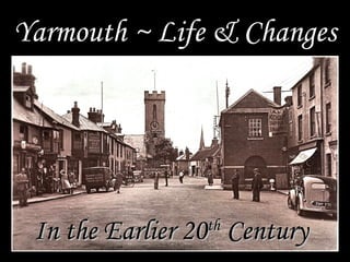
- 1. Yarmouth ~ Life & Changes In the Earlier 20 Century th
- 2. The Norman grid-work layout of Baldwin de Redvers new Town of Yarmouth in 1135
- 3. When Yarmouth’s first tidal mill was built in the 1660s, the flow of water between the River Yar and Thorley Brook was blocked by an embankment which created a mill pond behind it on the Thorley side. Here is the ‘new’ 1793 tidal mill - for making flour.
- 4. Yarmouth in 1718 – Two MPs ‘served’ this tiny community for nearly 250 years!
- 5. A strong north wind produces troubles off shore in the 1830s or early 1840s
- 6. Yarmouth in 1838 (by Brannon) Notable: the Old Sand House (Hayles Boatyard, one of the oldest buildings in Yarmouth), the Mill (1793) and in the distance Freshwater Church
- 7. Yarmouth in 1865 (the same Brannon print amended and updated !!) Now Note: the new Breakwater and Harbour (built1843-47) and the new Bridge connecting with Norton (opened 1860)
- 8. Yarmouth from the old bridge (opened 1860), photographed c. 1875
- 9. Some 40 years on (c.1906) and little had changed!
- 10. Photograph of the Pier entrance c. 1890 – Note the ‘Posting Establishment’ on the left and the Dolphin Inn beyond.
- 11. The Impressively Smart Post Office Staff c.1910
- 12. The Pier Staff in the early 1920s
- 13. The Pier Staff with local Transport Men c. 1930
- 14. The Solent Yacht Club just months after its opening in 1898
- 15. ‘Red Wings’ at the Solent Yacht Club Regatta of 1902
- 16. The Square, looking towards the Solent, in c.1890
- 17. The Buildings in today’s Pier Square, which were demolished in 1894
- 18. Quay Street and the front of The George Hotel in 1867 The George was enlarged to replace the buildings on the right in the 1890s and was re-opened in 1897 as the Pier Hotel, which it remained until 1929.
- 19. The Pier Hotel c. 1905 – with today’s familiar George having been extended
- 20. The ‘George’ in 1905 – Renamed the Pier Hotel between 1897 and 1929
- 21. The paddle-steamer ‘Freshwater’ The end of the Pier was the point of entry & departure for foot passengers
- 22. The passenger p/s ‘Freshwater’ : in service from 1927 to 1959
- 24. Cars being carried in ‘Tow-Boats’ across the Solent in the mid-1930s
- 25. Loading Transport Boats at the Quay in the early 1930s
- 26. Notice the Gasometers Preparation of the New Quay and Slipway in 1938
- 27. Unloading on the new Slipway in 1938 – the year the first car ferry was introduced
- 28. The Lymington – The first (roll-on-roll-off) Car Ferry – for which the new Quay was built, entered service in 1938
- 29. Harry Mills’s ‘Supply Store’ in c. 1913 N.B. Notice all the local shop fronts stretching up the High Street
- 30. Fryer’s Butcher Shop in the High Street c. 1913
- 31. Mr. Jack Fryer in c.1920
- 32. Harry Mills & Son c 1930
- 33. Mr. Elderfield with his Donkey and ‘Dust Cart’ c. 1930
- 34. The Mew Langton Dray in Yarmouth (where?) between the Wars, probably in the 1920s
- 35. Farm Workers at Thorley – thought to be c 1912
- 37. Watching the Meet of the IW Foxhounds in 1909
- 38. Across the Road at the same Meet in 1909
- 39. The Cast of the Yarmouth Pageant – ‘Pier’ Hotel Garden, c.1928
- 40. IOW League Winners Yarmouth United F.C. 1921-22
- 41. The Opening of the Recreation Ground in 1935
- 42. ‘Dolphin Cottages’, one-time tea rooms, being visited by royalty – perhaps Queen Mary or Princess Beatrice in the 1920s?
- 43. Yarmouth Carnival Queen of 1912 Miss Rita Hall
- 44. Mr Jim Cooper – with a large balloon Yarmouth Carnival Celebrations in 1948
- 45. The Common and The Mount c. 1914
- 46. The Mount - from the South side
- 47. The Last of the Dashwoods: Theresa, Cuthbert, Caroline & Constance (d.1966)
- 48. A Garden Party at Westhill in 1908 Note: HMS Gladiator being salvaged in the background
- 49. First Motor Lifeboat ‘B.A.S.P.’ which served Yarmouth from 1924 – 1934. It was 45 feet long and could do 8 knots
- 50. The Lifeboat Crew in 1925
- 51. Yarmouth School in 1867
- 52. Planting the Coronation Oak – August 9th 1902
- 53. Yarmouth Schoolgirls - 1921
- 54. Effy Pitman and her cousins c.1930?
- 55. St James’s Church Completed in 1626 The main entrance to the church was, in line with most, at the western end. Only when motor traffic made that too dangerous did the side (Northern door) become the entrance which we still use.
- 56. A beach outing for the Rector and group of Sunday School teachers
- 57. The locomotive ‘Freshwater’ on a trial trip on the new Railway at Yarmouth in 1888
- 58. Yarmouth Station The Railway embankment across the modern marshes probably ruined the millpond and possibly explained the final decline of the Mill in the late C19th
- 59. A Train steaming across the flooded Marshes (of Thorley Haven) in October 1909
- 60. The Island had a good Railway Network by the mid 20th century, though with only one line to the West Wight, which closed in 1953
- 61. A train from Newport arriving at Yarmouth Station
- 62. Yarmouth Harbour c.1867 Notice how much of it was silted up – and here not even at low tide
- 63. Aerial View from the West in the 1920s
- 64. Yarmouth in 1937 * Notice the main road from the Old Bridge ran straight into the Square * There was no Ticket Office (or Shenanigans) hiding the Castle wall By 1986-7 much new land had been reclaimed, including * Nearly all of theextended quay for the ferry and the new public the widely current Slipway area, along with the Green, the Car Park and the Main Road skirting Yarmouth from the roundabout ring-road sytem linking with the new bridge were still under water … at least at high tide
- 65. Back Lane (Tennyson Road) c.1920 which led to ‘The Mount’ until 1966
- 66. To Conclude …. Yarmouth Square – abuzz with activity – in the late 1950s
- 67. 1000 900 800 POPULATION 700 NO of HOUSES 600 500 400 300 200 100 0 1000 1150 1250 1350 1450 1550 1650 1750 1850 1900 1950 2000 Best Estimates of the Fluctuating Population of Yarmouth over the Past 1000 Years
- 68. Other Pictures for Inclusion Next Time Smiths welcomed 1948 Passenger Shelter – Sandhard The Common 1912 The Home Guard The Scouts 1918 The Common End of High Street (inc Milkman)
- 69. The grid lay-out of the original Norman town of Yarmouth The Solent Sea East Gate Gate The Square River Hither Gate Yar
- 70. ‘Sea Birds’ at the Solent Yacht Club Regatta of 1902
- 71. An Aerial View looking across Yarmouth Harbour pre-1938