Sea Level Change and Coastal Hazards in Washington
•
2 recomendaciones•861 vistas

Many factors contribute to Sea Level Rise. Learn more here!

Recomendados
Más contenido relacionado
La actualidad más candente
La actualidad más candente (20)
Destacado
Destacado (20)
Similar a Sea Level Change and Coastal Hazards in Washington
Similar a Sea Level Change and Coastal Hazards in Washington (20)
Más de Sheila Wilson
Más de Sheila Wilson (13)
Último
Último (20)
Sea Level Change and Coastal Hazards in Washington
- 1. Bobbak Talebi Department of Ecology Sea Level Change and Coastal Hazards in Washington
- 2. Sea Level Change in Washington Lara Whitely Binder Climate Impacts Group University of Washington
- 3. For More Details… National Research Council – April 2012IPCC 2013, WG1, Chapter 13 Mote et al. 2008
- 4. Future Greenhouse Gas Scenarios • The previous scenarios have close analogues in the newer scenarios • In both sets of scenarios, the high end is a “business as usual” scenario (RCP 8.5, SRES A1FI) • The newer scenarios include an aggressive mitigation scenario (RCP 2.6) • All scenarios result in similar warming until about mid-‐century. • Greenhouse gas scenarios are consistent with recent global emissions.
- 5. What Do We Know About Global Sea Level Rise? Sea level has been rising. “Virtually certain” that the rate of global sea level rise has increased over the last two centuries. IPCC 2013, Figure SPM.3 1901-2010: +0.06 in/year (+7.5 inches total) 1993-2010: +0.13 in/year (a trend or natural variability?)
- 6. Global Mean SLR Projections Range of projected rise for 2100, relative to 1986-2005: +11 to +38 in. RCP 2.6: +17 in. (range: 11-24 in.) RCP8.5: +29 in. (range: 21-38 in.) Figure adapted from IPCC 2013, Technical Summary for Policy Makers Solid lines= median value Dashed lines = likely ranges for RCP4.5 and RCP6.0 Shading = likely ranges for RCP2.6 and RCP8.5
- 7. Why is SLR not one number? Assumptions about future greenhouse gas emissions matter. Different levels of greenhouse gas emissions result in a range of projections for temperature, thermal expansion, etc. Van Vuuren et al. 2011: http://emf.stanford.edu/files/docs/340/Moss_10.1007-s10584-011-0148-z.pdf
- 8. Regional Sea Level CHANGE Observed changes and projections Photo source: http://www.sequim-real-estate-blog.com/water-
- 9. Sea level change at any given location and point in time is determined by many factors NRC 2012 (+) (+ or -) (+ or -) (not incl.) (-) (+) (+)
- 10. Rates for vertical land movement are highly variable Red = uplift Blue = subsidence Major Contributing Factors: Plate tectonics Soil compaction Figure source: NRC 2012
- 11. Observed Trends Seattle Sea level rise of about +8 inches for 1898-2006 (equivalent to a change of +0.68 feet in 100 years) Source: NOAA Tides and Currents
- 12. Observed Trends Neah Bay Sea level fall between 1934 and 2006 (equivalent to a change of -0.53 feet, or -6.4 inches, in 100 years) Source: NOAA Tides and Currents
- 13. Washington State Sea Level Rise (Mote et al. 2008) Medium (w/range) estimates of sea level rise in Washington for 2100: . NW Olympic Peninsula: +2” (-9 to +35”) Central/Southern Coast: +11” (+2 to +43”) Puget Sound: +13” (+6 to +50”)
- 14. NRC 2012 vs. Mote et al. 2008 Figure source: Climate Impacts Group
- 15. NRC 2012 vs. Mote et al. 2008 Figure source: Climate Impacts Group Bottom line: both provide similar ranges and a good scientific foundation for planning, although differences in vertical land movement may be important in other locations.
- 16. “The” number will depend on… • The expected time horizon of the decision being made (e.g., 20 years vs. 100 years), • The ability to adapt the decision over time, • Available alternatives, • Risk tolerance, and • Cost among other factors…
- 17. Alki Beach, West Seattle Photo by Hugh Shipman, WA Dept of Ecology What Does 2 Feet of SLR Look Like?
- 18. Alki Beach, West Seattle, January 21, 2010 Photo by Hugh Shipman, WA Dept. of Ecology
- 19. Near-term Challenges of SLR Sea level rise increases storm surge and the risk of: • flooding, • erosion, • habitat loss These impacts will affect coastal areas long before permanent inundation.
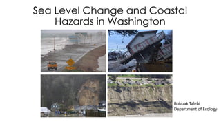
- 22. Erosion
- 24. Landslides
- 26. Storm Surge
- 27. Why is this important to consider? Populations Buildings Infrastructure Natural Resources Historic Resources Cultural Resources Economic Resources Contaminated Lands Parks
- 28. What concerns do you have about sea level rise?
- 29. We already do this work
- 30. Regional efforts Climate Change Preparedness Plan for the North Olympic Peninsula • Diminishing snowpack • Shifts in precipitation • Sea level rise • Extended warm temperatures • Ocean acidification
- 31. Local efforts
- 32. Design efforts
- 33. You are not alone • More support and energy from the public up to the federal government • Many local governments are interested in taking action • Building a community of practice
- 34. Bobbak Talebi Coastal Planner Washington Department of Ecology Bobbak.Talebi@ecy.wa.gov Questions?