
Denunciar
Compartir

Recomendados
3
1. Various monitoring techniques are used to predict volcanic eruptions, including measuring seismic activity, ground deformation, gas emissions, and changes in nearby streams. This allows for evacuation planning and hazard mapping.
2. Primary volcanic hazards like lava flows and pyroclastic flows directly impact people. Secondary hazards like lahars and acid rain can also harm people and the environment. Monitoring and evacuation are the most effective hazard management strategies.
3. While some attempts have been made to control lava flows, volcanic eruptions cannot fully be controlled. The most effective approaches are hazard mapping, land use planning, education and preparedness activities to reduce vulnerability and respond to eruptions.
Rischio vulcani b-short
This document summarizes the global scale of volcanic hazards and impacts. It discusses several notable eruptions throughout history in terms of their explosivity (VEI), ash and gas emissions, climate impacts like cooling, and effects on societies including famine, disease outbreaks, and civilization changes. The largest known eruption was Toba in Indonesia approximately 75,000 years ago estimated at VEI 8, which caused global cooling of 3-5°C and may have reduced the human population to less than 20,000.
Pakistan Floods
Heavy monsoon rains caused widespread flooding across Pakistan in 2010, affecting over 20 million people. The floods were considered the worst in Pakistan's history, destroying infrastructure and displacing many residents from their homes. Relief efforts struggled for months to help those impacted by the massive flooding and damage across the country.
GEOG2 2014
Heavy monsoon rains caused widespread flooding across Pakistan in June 2004. Over 1,000 people were killed and over 1 million homes were destroyed by the flooding, which was described as the worst natural disaster in Pakistan's history. Vast areas of the country were submerged, including the provinces of Sindh, Punjab and Balochistan.
The World At Risk
The document discusses natural hazards and disasters. It defines hazards as natural events that involve people, where social and environmental factors can turn an event into a disaster. There are two main classifications of hazards: hydro-meteorological hazards caused by weather patterns like floods and storms, and geophysical hazards caused by earth processes like earthquakes, volcanoes, and landslides. A disaster is defined as a natural event that causes human or economic losses. While the number of deaths from disasters has decreased due to better preparedness, the number of people affected and economic costs have risen due to increasing population in vulnerable areas and climate change impacts.
Volcanic Hazards Slides
The document discusses various volcanic hazards including primary hazards of ash fall and lava flow. It also discusses pyroclastic flows which can travel at 200 km/hr, volcanic gases such as CO2, H2O and SO2, secondary hazards of lahars from eruptions such as Nevado del Ruiz in 1985, and tertiary hazards of global climate change from large eruptions like Mt. Tambora in 1815 and Mt. Pinatubo in 1991.
Unit 4 Pre Release
The document discusses tectonic hazards and their impacts on communities. It explores the different types and levels of challenges posed by varying forms of tectonic activity such as earthquakes, tsunamis, and volcanic eruptions. It examines how the impacts of tectonic hazards vary depending on location and economic development through case studies of contrasting locations. Approaches to reducing risks from tectonic hazards are also discussed.
Tectonics: Volcanic hazards
A description of the main types of hazards produced by volcanoes, and some notes on case studies and management.
World At Risk Global Hazards
Global hazards include hydro-meteorological hazards caused by climate processes like droughts and floods, and geophysical hazards caused by land processes like earthquakes and volcanic eruptions. The risk of disaster is determined by the hazard, a population's vulnerability, and their capacity to cope. While the number of geophysical hazards has remained steady, hydro-meteorological hazards are increasing due to global warming. Deaths from disasters have decreased due to improved risk management strategies like prediction, prevention, and preparedness, but global economic losses from disasters are rising rapidly.
Volcanic Hazard
Pyroclastic flows are one of the most dangerous aspects of volcanism as they can travel rapidly and kill through suffocation and burning. Lava flows are generally less explosive but can destroy anything in their path. Large eruptions can also trigger secondary hazards like mudflows, landslides, and tsunamis that increase damage far from the volcano. Long term effects include crop damage, famine, disease, and global cooling from volcanic gases that reflect sunlight.
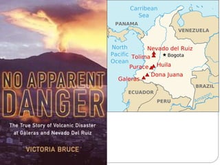
Nevado del ruiz case study
Nevado Del Ruiz volcano in Colombia erupted in 1985, sending ash 30km into the air and melting glaciers which caused deadly lahars. The lahars flowed at 40mph, reached 50m wide, and killed 23,000 people as they destroyed the town of Armero. The hazard was not properly managed as scientists warned of the risk of lahars but officials failed to evacuate areas despite continuing volcanic activity in the months before the eruption.
Global Hazards
The document discusses various natural hazards that can cause disasters including depressions, hurricanes, droughts, floods, tornadoes, wildfires, volcanoes, earthquakes, tsunamis, landslides and avalanches. It describes the physical processes that cause each hazard and their potential impacts, such as property damage, deaths or injuries. The document also discusses concepts of risk, vulnerability and capacity, noting that hazards combined with vulnerability can lead to disasters, while greater capacity can reduce risk and impacts.
Fieldwork Cranedale
This document outlines the methodology and risk assessment for a fieldwork investigation measuring the velocity of the River Derwent in the North York Moors. Three sites were chosen along a 12km stretch of the river to measure how velocity changes downstream. A risk assessment was conducted and control measures like appropriate clothing and footwear, first aid kits, and working in groups were implemented. Primary data on river velocity was collected using a hydroprop at set points across cross-sections of the river channels. The investigation aimed to understand how velocity is influenced by changes in factors like gradient, hydraulic radius, and roughness as the river flows downstream.
Water Balance VLE
The water balance, or budget, is a simple equation used to understand water resources in a drainage basin. It accounts for precipitation, evapotranspiration, infiltration into soils, storage of water in soils, and outputs like surface runoff and flow into rivers. When precipitation exceeds evapotranspiration, soils become saturated and excess water runs off as overland flow, contributing to rivers. When evapotranspiration is greater than precipitation, stored soil moisture is reduced and depleted.
STRUCTURE OF THE ATMOSPHERE
The document discusses the structure and composition of Earth's atmosphere. It is divided into four layers: the troposphere, stratosphere, mesosphere, and thermosphere. Each layer has distinct temperature and chemical characteristics. The troposphere contains around 80% of the atmosphere and is where weather occurs. Temperatures decrease with height in the troposphere. The stratosphere has temperatures that increase with height due to ozone absorbing UV radiation. The mesosphere has temperatures that decrease rapidly with no gases to absorb radiation.
20 monsoon climate
The Indian monsoon climate is characterized by distinct wet and dry seasons. From June to September, the southwest monsoon brings heavy rainfall to areas like Kerala on the Malabar Coast, with some places receiving over 3,000 mm of rain during this period. The arrival and retreat of the monsoon is crucial to India's agriculture and economy, as nearly 75% of the rain falls during this time which supports over half of India's population that depends on agriculture for their livelihood.
SAND DUNES - AINSDALE
The document provides guidance on studying coastal sand dunes, including describing the flora and fauna found in different areas of dunes and explaining how environmental conditions affect plant and animal life. It also discusses sustainable management of dune systems, identifying potential conflicts between dune users and strategies for conserving dunes for future generations, such as managing threats from human activities that cause erosion. The document uses Ainsdale Dunes as a case study location.
Flood Somerset
Winter 2013/14 saw prolonged heavy rain and flooding on the Somerset Levels in central Somerset, England. The Levels are a flat coastal plain lying close to sea level that is mainly used for agriculture. Hundreds of homes were affected, villages were cut off, and major roads were blocked by the flooding. Farmers struggled to graze animals or were forced to evacuate livestock. Responses included rescue boats, military assistance, and promises of funds for repairs, while longer term plans involved improving drainage through dredging, raising flood defenses, and installing permanent pumps. However, some argue for more sustainable options such as slowing floodwater through tree planting and pond creation or allowing some areas to naturally return to wetland.
NARGIS - TROPICAL REVOLVING STORMS
Tropical Storm Nargis caused massive destruction in Burma, with estimates of at least 100,000 deaths and over a million people made homeless or without access to clean water and food. Local partners have started providing relief to 20,000 families in the worst-hit Irrawaddy delta region, distributing blankets, medicines, and water purification tablets from resources they had available, but many parts of the delta remain unreached and people are struggling to survive as diseases spread. The local partners are leading response efforts but have limited supplies that will run out unless the Burmese government allows more international aid into the country.
NIGER PERIODIC FAMINE
The document discusses periodic famines that occur in Niger due to regional failures in food production or distribution systems. It describes Niger's geography and climate, with the northern half being part of the Sahara desert and the central and southern regions receiving more rainfall. Farming practices vary by region, from nomadic herding in the north to agro-pastoral systems and permanent villages in the central and south. The 2005 famine in Niger is examined, caused by below average rainfall and locust plagues that reduced crop yields, combined with poverty, high food prices, and depleted government food reserves. Short term responses included food aid while long term solutions focused on irrigation, dams, wells, and agricultural development.
MALNUTRITION
Malnutrition increases the risk of disease and early death. A balanced diet should comprise 60% carbohydrates, 20% protein, and 20% fat, along with sufficient vitamins, minerals, and roughage. Marasmus is a severe form of malnutrition caused by inadequate protein and calorie intake, resulting in wasting, growth retardation, decreased activity, lethargy, behavioral changes, slowed growth, and weight loss. Children with marasmus rarely return to normal growth standards.
GLOBAL URBANISATION
Tokyo is currently the largest city in the world by population, with over 34 million residents. Urbanization is the increasing percentage of the human population living in cities and urban areas, often at the expense of rural areas. Rapid urbanization has seen the populations of many cities, especially in developing regions of Asia, Africa, and Latin America, grow rapidly over recent decades. The top 20 largest cities by population in the world are all over 10 million residents, with over half located in Asia.
Weathering
This document defines weathering as the breakdown of rocks through three main processes: biological, chemical, and physical weathering. It provides details on each type of weathering. Chemical weathering involves carbon dioxide mixing with rainwater to form a weak acid that dissolves rocks like limestone. Biological weathering occurs as plants and animals break rocks down by growing in cracks or digging. Physical weathering includes onion skin weathering (exfoliation) where temperature changes cause rock layers to peel and freeze-thaw weathering where water freezing in cracks breaks rocks apart. The document instructs students on assignments to complete about the conditions that cause the strongest chemical and physical weathering.
Katse dam
The document discusses international aid and provides an example of the Katse Dam project in Lesotho. It defines the three main types of international aid as bilateral, multilateral, and non-governmental. It also describes the World Bank as a major provider of multilateral aid through low-interest loans and grants for infrastructure and development projects. As a case study, it introduces the Katse Dam project in Lesotho funded by the World Bank to generate hydroelectric power, and notes the learning objectives are to identify different aid types, analyze advantages and disadvantages of large projects, and determine a project's effectiveness.
RELATIVE CHANGE
Relative change is calculated by taking the difference between the new value and the original value, and dividing that difference by the original value. This calculation is then multiplied by 100 to express the change as a percentage rather than a decimal. Relative change allows you to understand the proportional change between the original and new value.
OBESITY
Obesity is a global health issue, defined as abnormal or excessive fat accumulation that may impair health. According to the WHO, in 2005 over 1.6 billion adults were overweight and 400 million were clinically obese, numbers that are expected to surge significantly by 2015. Obesity prevalence varies widely between countries but is rising almost everywhere, posing serious health risks like increased chances of diseases such as cardiovascular disease and diabetes. Explanations for the global rise of obesity include nutrition transitions to highly processed diets and increasingly sedentary lifestyles in many societies. The WHO recognizes obesity as a global epidemic with over 2.3 billion people projected to be overweight by 2015.
OBESITY QUESTIONS
This document appears to be a list of health-related data points organized by date ranging from January 2010 to June 2014. The data includes numbers from 3 to 15 for various dates between January and June of years 2010 through 2014.
SETTLEMENT
This document lists the settlement dates for GCSE and IGCSE exams from June 2010 to June 2013. GCSE exams were held in June 2013, June 2012, June 2011 and June 2010. IGCSE exams were held in June 2013.
Ocean Currents 1
Ocean currents exist to help balance the Earth's uneven heating by the Sun. The Sun deposits most of its energy at the equator, so atmospheric circulation and ocean currents transfer heat from the equator toward the poles. Winds drive 80% of this redistribution, while ocean currents account for 20%. Surface ocean currents form circular gyre patterns in ocean basins, driven by subtropical high pressure systems, and affect the locations of deserts on western continents in the Southern Hemisphere. Deep ocean currents also circulate heat but over much longer timescales of around 1,000 years.
Altitude 1
The document describes the temperature changes that occur when air rises up the windward side of a 3000m mountain located on the coast in mid-latitudes. As the air rises and cools at the dry adiabatic lapse rate of 10°C per 1000m, it reaches the lifting condensation level of 2000m where condensation begins and the rate of cooling decreases to the saturated adiabatic lapse rate of 5°C per 1000m. At the top of the mountain, the air temperature is 1°C. As the air subsides on the leeward side, its temperature increases according to the dry adiabatic lapse rate, making that side warmer and drier than the windward side
Más contenido relacionado
Destacado
World At Risk Global Hazards
Global hazards include hydro-meteorological hazards caused by climate processes like droughts and floods, and geophysical hazards caused by land processes like earthquakes and volcanic eruptions. The risk of disaster is determined by the hazard, a population's vulnerability, and their capacity to cope. While the number of geophysical hazards has remained steady, hydro-meteorological hazards are increasing due to global warming. Deaths from disasters have decreased due to improved risk management strategies like prediction, prevention, and preparedness, but global economic losses from disasters are rising rapidly.
Volcanic Hazard
Pyroclastic flows are one of the most dangerous aspects of volcanism as they can travel rapidly and kill through suffocation and burning. Lava flows are generally less explosive but can destroy anything in their path. Large eruptions can also trigger secondary hazards like mudflows, landslides, and tsunamis that increase damage far from the volcano. Long term effects include crop damage, famine, disease, and global cooling from volcanic gases that reflect sunlight.
Nevado del ruiz case study
Nevado Del Ruiz volcano in Colombia erupted in 1985, sending ash 30km into the air and melting glaciers which caused deadly lahars. The lahars flowed at 40mph, reached 50m wide, and killed 23,000 people as they destroyed the town of Armero. The hazard was not properly managed as scientists warned of the risk of lahars but officials failed to evacuate areas despite continuing volcanic activity in the months before the eruption.
Global Hazards
The document discusses various natural hazards that can cause disasters including depressions, hurricanes, droughts, floods, tornadoes, wildfires, volcanoes, earthquakes, tsunamis, landslides and avalanches. It describes the physical processes that cause each hazard and their potential impacts, such as property damage, deaths or injuries. The document also discusses concepts of risk, vulnerability and capacity, noting that hazards combined with vulnerability can lead to disasters, while greater capacity can reduce risk and impacts.
Fieldwork Cranedale
This document outlines the methodology and risk assessment for a fieldwork investigation measuring the velocity of the River Derwent in the North York Moors. Three sites were chosen along a 12km stretch of the river to measure how velocity changes downstream. A risk assessment was conducted and control measures like appropriate clothing and footwear, first aid kits, and working in groups were implemented. Primary data on river velocity was collected using a hydroprop at set points across cross-sections of the river channels. The investigation aimed to understand how velocity is influenced by changes in factors like gradient, hydraulic radius, and roughness as the river flows downstream.
Water Balance VLE
The water balance, or budget, is a simple equation used to understand water resources in a drainage basin. It accounts for precipitation, evapotranspiration, infiltration into soils, storage of water in soils, and outputs like surface runoff and flow into rivers. When precipitation exceeds evapotranspiration, soils become saturated and excess water runs off as overland flow, contributing to rivers. When evapotranspiration is greater than precipitation, stored soil moisture is reduced and depleted.
STRUCTURE OF THE ATMOSPHERE
The document discusses the structure and composition of Earth's atmosphere. It is divided into four layers: the troposphere, stratosphere, mesosphere, and thermosphere. Each layer has distinct temperature and chemical characteristics. The troposphere contains around 80% of the atmosphere and is where weather occurs. Temperatures decrease with height in the troposphere. The stratosphere has temperatures that increase with height due to ozone absorbing UV radiation. The mesosphere has temperatures that decrease rapidly with no gases to absorb radiation.
Destacado (7)
Más de GeoCoops
20 monsoon climate
The Indian monsoon climate is characterized by distinct wet and dry seasons. From June to September, the southwest monsoon brings heavy rainfall to areas like Kerala on the Malabar Coast, with some places receiving over 3,000 mm of rain during this period. The arrival and retreat of the monsoon is crucial to India's agriculture and economy, as nearly 75% of the rain falls during this time which supports over half of India's population that depends on agriculture for their livelihood.
SAND DUNES - AINSDALE
The document provides guidance on studying coastal sand dunes, including describing the flora and fauna found in different areas of dunes and explaining how environmental conditions affect plant and animal life. It also discusses sustainable management of dune systems, identifying potential conflicts between dune users and strategies for conserving dunes for future generations, such as managing threats from human activities that cause erosion. The document uses Ainsdale Dunes as a case study location.
Flood Somerset
Winter 2013/14 saw prolonged heavy rain and flooding on the Somerset Levels in central Somerset, England. The Levels are a flat coastal plain lying close to sea level that is mainly used for agriculture. Hundreds of homes were affected, villages were cut off, and major roads were blocked by the flooding. Farmers struggled to graze animals or were forced to evacuate livestock. Responses included rescue boats, military assistance, and promises of funds for repairs, while longer term plans involved improving drainage through dredging, raising flood defenses, and installing permanent pumps. However, some argue for more sustainable options such as slowing floodwater through tree planting and pond creation or allowing some areas to naturally return to wetland.
NARGIS - TROPICAL REVOLVING STORMS
Tropical Storm Nargis caused massive destruction in Burma, with estimates of at least 100,000 deaths and over a million people made homeless or without access to clean water and food. Local partners have started providing relief to 20,000 families in the worst-hit Irrawaddy delta region, distributing blankets, medicines, and water purification tablets from resources they had available, but many parts of the delta remain unreached and people are struggling to survive as diseases spread. The local partners are leading response efforts but have limited supplies that will run out unless the Burmese government allows more international aid into the country.
NIGER PERIODIC FAMINE
The document discusses periodic famines that occur in Niger due to regional failures in food production or distribution systems. It describes Niger's geography and climate, with the northern half being part of the Sahara desert and the central and southern regions receiving more rainfall. Farming practices vary by region, from nomadic herding in the north to agro-pastoral systems and permanent villages in the central and south. The 2005 famine in Niger is examined, caused by below average rainfall and locust plagues that reduced crop yields, combined with poverty, high food prices, and depleted government food reserves. Short term responses included food aid while long term solutions focused on irrigation, dams, wells, and agricultural development.
MALNUTRITION
Malnutrition increases the risk of disease and early death. A balanced diet should comprise 60% carbohydrates, 20% protein, and 20% fat, along with sufficient vitamins, minerals, and roughage. Marasmus is a severe form of malnutrition caused by inadequate protein and calorie intake, resulting in wasting, growth retardation, decreased activity, lethargy, behavioral changes, slowed growth, and weight loss. Children with marasmus rarely return to normal growth standards.
GLOBAL URBANISATION
Tokyo is currently the largest city in the world by population, with over 34 million residents. Urbanization is the increasing percentage of the human population living in cities and urban areas, often at the expense of rural areas. Rapid urbanization has seen the populations of many cities, especially in developing regions of Asia, Africa, and Latin America, grow rapidly over recent decades. The top 20 largest cities by population in the world are all over 10 million residents, with over half located in Asia.
Weathering
This document defines weathering as the breakdown of rocks through three main processes: biological, chemical, and physical weathering. It provides details on each type of weathering. Chemical weathering involves carbon dioxide mixing with rainwater to form a weak acid that dissolves rocks like limestone. Biological weathering occurs as plants and animals break rocks down by growing in cracks or digging. Physical weathering includes onion skin weathering (exfoliation) where temperature changes cause rock layers to peel and freeze-thaw weathering where water freezing in cracks breaks rocks apart. The document instructs students on assignments to complete about the conditions that cause the strongest chemical and physical weathering.
Katse dam
The document discusses international aid and provides an example of the Katse Dam project in Lesotho. It defines the three main types of international aid as bilateral, multilateral, and non-governmental. It also describes the World Bank as a major provider of multilateral aid through low-interest loans and grants for infrastructure and development projects. As a case study, it introduces the Katse Dam project in Lesotho funded by the World Bank to generate hydroelectric power, and notes the learning objectives are to identify different aid types, analyze advantages and disadvantages of large projects, and determine a project's effectiveness.
RELATIVE CHANGE
Relative change is calculated by taking the difference between the new value and the original value, and dividing that difference by the original value. This calculation is then multiplied by 100 to express the change as a percentage rather than a decimal. Relative change allows you to understand the proportional change between the original and new value.
OBESITY
Obesity is a global health issue, defined as abnormal or excessive fat accumulation that may impair health. According to the WHO, in 2005 over 1.6 billion adults were overweight and 400 million were clinically obese, numbers that are expected to surge significantly by 2015. Obesity prevalence varies widely between countries but is rising almost everywhere, posing serious health risks like increased chances of diseases such as cardiovascular disease and diabetes. Explanations for the global rise of obesity include nutrition transitions to highly processed diets and increasingly sedentary lifestyles in many societies. The WHO recognizes obesity as a global epidemic with over 2.3 billion people projected to be overweight by 2015.
OBESITY QUESTIONS
This document appears to be a list of health-related data points organized by date ranging from January 2010 to June 2014. The data includes numbers from 3 to 15 for various dates between January and June of years 2010 through 2014.
SETTLEMENT
This document lists the settlement dates for GCSE and IGCSE exams from June 2010 to June 2013. GCSE exams were held in June 2013, June 2012, June 2011 and June 2010. IGCSE exams were held in June 2013.
Ocean Currents 1
Ocean currents exist to help balance the Earth's uneven heating by the Sun. The Sun deposits most of its energy at the equator, so atmospheric circulation and ocean currents transfer heat from the equator toward the poles. Winds drive 80% of this redistribution, while ocean currents account for 20%. Surface ocean currents form circular gyre patterns in ocean basins, driven by subtropical high pressure systems, and affect the locations of deserts on western continents in the Southern Hemisphere. Deep ocean currents also circulate heat but over much longer timescales of around 1,000 years.
Altitude 1
The document describes the temperature changes that occur when air rises up the windward side of a 3000m mountain located on the coast in mid-latitudes. As the air rises and cools at the dry adiabatic lapse rate of 10°C per 1000m, it reaches the lifting condensation level of 2000m where condensation begins and the rate of cooling decreases to the saturated adiabatic lapse rate of 5°C per 1000m. At the top of the mountain, the air temperature is 1°C. As the air subsides on the leeward side, its temperature increases according to the dry adiabatic lapse rate, making that side warmer and drier than the windward side
China a NIC
China has experienced rapid economic growth in recent decades, with annual growth rates around 6-7%. This is due to economic reforms and opening up to foreign trade and investment, including joining the WTO. However, questions remain about whether China's high growth can be sustained long-term given potential weaknesses such as demographic changes, environmental problems, and overreliance on exports and infrastructure investment. A thorough analysis of China's strengths, weaknesses, opportunities, and threats would be needed to assess sustainability.