SlideShare una empresa de Scribd logo
1 de 36
Descargar para leer sin conexión
What’s New in
                     KINGDOM Version 8.6
KINGDOM version 8.6 includes the following new features for KINGDOM Core and
KINGDOM Advanced.

              KINGDOM v8.6 Features                KINGDOM KINGDOM
                                                     Core  Advanced
 KINGDOM-Wide Capabilities
 New KINGDOM Fault System

 Deviated Well Borehole Arbitrary Line

 Rulers on Base Maps and Vertical Displays

 New Well Data Refresh Functionality

 Base Map Scale Bar

 Transparency for Polygons

 Notifications Tab in User Preferences

 Enhanced Project Security

 VuPAK
 Microseismic Analysis—New Functionality

 Microseismic—Multiple Attribute Filtering

 Reconstructed Project Annotations

 New Interface for Project and Survey Annotation

 2d/3dPAK
 Preferred Mode—Misties Tables

 Preferred Mode—Time Depth Chart Lists

 Horizon Editing Tools


KINGDOM 8.6                                                                    1
Horizon Editing Tool—Erase by Attribute

Horizon Picking Tools

Sync Report for Seismic Slice Volumes

EarthPAK
Display TVD (Reference Elevation) along Borehole

Export Monthly and Cumulative Production

Improved Authoring of Zones and Zone Attributes

VelPAK
Ease of Use Enhancements

User Interface Enhancements

Curve Tool Enhancements

Workflow Tool

Surface Tool

Well Tool


Learn more about KINGDOM through these resources on the SMT Web site:
•   Training Course Catalog
•   Getting Started Services
•   The KINGDOM Newsletter
•   Technical Webinars


2                                                                KINGDOM 8.6
KINGDOM-Wide Capabilities

New KINGDOM Fault System
Improved Technology for Better Faults

The New Fault System is a complete redesign of the original fault system to provide a
more accurate interpretation with new tools to modify fault surfaces.
•     A new triangulation engine provides better fault surfaces.
•     Fault smoothing using flex grid technology smooths one or all fault surfaces.
•     Fault polygons are created using the exact line of intersection between the fault and the
      horizon or grid.


                                                           Fault polygons are calculated as the
                                                           precise intersection between the
                                                           horizon and the fault surface.


                                                           The polygons can then be used for
                                                           gridding and contouring. Fault
                                                           polygons contain Z-values which
                                                           assist in contouring around the faults.


    The New Fault System
    provides improved
    integration into 3D
    visualization in VuPAK.


KINGDOM 8.6                                                                                          3
The fault smoothing
                                                                               tool allows the
                                                                               geoscientist to
                                                                               smooth one or all
                                                                               faults in a project
                                                                               with a single button
                                                                               click.
                                                                               Smoothing uses
                                                                               Flex Grid
                                                                               technology.
                                                                               Set the amount of
                                                                               smoothing to apply
                                                                               and create new,
                                                                               smoothed faults or
                                                                               replace existing
                                                                               faults.


    When required, additional smoothing automatically finds outliers and removes them from
    the interpretation.


4                                                                                    KINGDOM 8.6
New KINGDOM Fault System (con’t)
Groundwork Set for Future Fault Enhancements

The New Fault System contains additional capabilities that allow KINGDOM to
expand fault enhancements into the future.
•    Better fit between segment and surface views.
•    Vertical separation as an attribute on the fault surface.
•    Dozens of additional enhancements.

                                                                 The red fault to the
                                                                 left shows both the
                                                                 surface and
                                                                 segment.
                                                                 The new fault
                                                                 system will create
                                                                 surfaces that fit the
                                                                 segments digitized
                                                                 on the VSD.


    New fault
    management tools
    simplify fault
    handling.
    New tools provide
    options to
    manipulate vertical
    separation.


KINGDOM 8.6                                                                              5
Deviated Well Borehole Arbitrary Line
Create an Arbline along a Single, Deviated Well

New functionality has been added to seismic arbitrary line creation. In order to
faithfully represent the path of a deviated well through a structurally complex setting,
this new functionality creates an arbitrary line that accurately follows the well path
with a single click.
•   This new arbitrary line will be created automatically along a single deviated well borehole.
•   Users can select 'Single along One Deviated Borehole' from the usual list of arbitrary line
    methods, then click a deviated well symbol.
•   An arbitrary line will draw along the exact path of the well's deviation survey.


•   This new arbitrary line possesses the full capabilities of any Kingdom geologic or 3D
    surveys data based arbitrary line.


6                                                                                  KINGDOM 8.6
Rulers on Base Maps and Vertical Displays
Measure Azimuth and Angle

The geoscientist often needs a way to measure azimuth on a base map. This could
be surface lineations on an air photo or a linear trend on a contoured map. KINGDOM
now shows the Azimuth of a line digitized with the Base Map Ruler, referenced to
either True North or Grid North.


To meet the needs of the geologist who is geosteering a deviated well, as well as
mapping structural trends, we have added a vertical display ruler that shows the
Lateral Distance, Depth Shift and Dip or Inclination of a digitized line on a vertical
display.


KINGDOM 8.6                                                                              7
New Well Data Refresh Functionality
Refresh Wells from the Database

Multiple options to easily refresh wells from the database are provided, allowing users
in multi-user project environments to keep their data in sync without disrupting their
workflows.

•   Right-click a well symbol
    to refresh a well from the
    database.


•   Right-click a well subset in
    the Project Tree to refresh
    the wells in the subset
    from the database. The
    subset can be dynamic or
    static.


•   Right-click a base map to
    refresh the visible wells
    from the database.


8                                                                          KINGDOM 8.6
Right-click to Add a Well to the Base Map
  Improved Well Planning

  In order to streamline well planning we have added the ability to right-click on a base
  map to add a new well location. This saves time when designing an exploitation
  program.
  •     Right-click on base map to add a well. The Well Edit dialog box is pre-populated with the
        X and Y locations of the point selected on the base map.
  •     All that needs to be added is a UWI, Reference elevation and Start and End depths.


                                      Right-click on the location for the proposed well on the Base Map and
                                      select Wells > Add Well at Current Location.
Cross-section through 2 wells as
displayed on the Base Map
                                                                                  The new well is
                                                                                  displayed on the
                                                                                  Base Map in the
                                                                                  designated
                                                                                  location.


Surface location XY coordinates are
populated in the Well Edit dialog.


      A new cross section
      through wells now
      includes 3 wells.


 KINGDOM 8.6                                                                                         9
Base Map Scale Bar
Movable, Resizable Scale Information

Scale bars may now be displayed in map views.
•    Selecting “Show Scale Bar” places a scale bar on the map.
•    This scale bar may be resized and moved to display anywhere within the visible map
     frame.
•    Windows copied into presentation documents can now easily convey scale information.


                                                  Specify the height of the Scale Bar and
                                                  customize the text attributes from the Scale tab
                                                  in Settings.


10                                                                                KINGDOM 8.6
Transparency for Polygons
Added Flexibility when Working with Polygons

New adjustable transparency slider controls provide more flexibility in the usage of
polygons.


 Adjust the transparency of the polygon
 with the slider. For correlation polygons,
 stretch and squeeze the polygon with ‘+’
 and ‘-’ respectively.


                                                                Correlation polygon
                                                                transparency provides more
                                                                precise correlation. This works
                                                                with raster logs too!


                                                                Transparency option is also
 Leverage adjustable transparency for correlation polygons on
 seismic VSD’s for improved jump correlations.
                                                                available for planimeter
                                                                polygons.


KINGDOM 8.6                                                                                       11
Hide/Show Location Rulers
Maximize your Interpretation Pallet
                                                             •Right-click on a ruler on a cross
                                                             section or VSD to hide the location
                                                             rulers.
                                                             •Work in maximized interpretation
                                                             pallet.


          •   Turn on the location rulers from
              View>Toolbars when desired.


Notifications Tab in User Preferences
Manage Well and Database Notifications in User Preferences
•    Turn of or off notification that new
     wells have been added to a project
     since last login when in author
     preferred time-depth chart mode.
•    Turn on or off database
     notifications:
     -   Prompt for project database
         conversion from MS Access to
         SQL, SQL Server Express, or
         Oracle
     -   Option to change SQL Server
         Express from Manual to Auto portability configuration
     -   Notification when exiting an Auto SSE project that another user is still in the project.
         The project database cannot automatically detach and become portable until all
         authors are out of the project.


12                                                                                  KINGDOM 8.6
Enhanced Project Security
Providing administrators the ability to set project level security in Oracle and
SQL Server environments

Security Levels
•   Administrator New!—Access and manage security settings.
•   All Authors—Allows users to select or switch to any author when they open a project.
•   Specific Authors New!—Allows a project administrator to assign one or more specific
    authors to a given windows user.
•   Work Tree Only—Restricts a named user to the context of an author/Work Tree
    combination within a project.
•   No Access—Completely restricts user from accessing a KINGDOM project.

                                                                             Set default
                                                                             access level for
                                                                             all users not
                                                                             specifically listed


                                                                             Sort or Filter the
                                                                             Effective
                                                                             Permissions
                                                                             table to easily
                                                                             review and
                                                                             update user
                                                                             access


                                                                             Set access level
                                                                             for each user if
                                                                             different from
                                                                             default


                                                                             Search Active
                                                                             Directory for
                                                                             valid windows
                                                                             users and assign
                                                                             specific
                                                                             permissions


KINGDOM 8.6                                                                                13
VuPAK

Microseismic Analysis—New Functionality
•    Load Microseismic data.
     -   Supports known contractor
         formats for microseismic
         event data and fracture
         treatment curves.
     -   Stores data with project.
     -   Provides attribute scaling &
         adjustment options.
•    Visualize data as part of regular
     interpretation:
     -   View microseismic data on all
         displays.
     -   Display in depth and time
         simultaneously.
     -   Control size and color based
         on Microseismic Event (MSE)
         attributes in all views.
•    Analyze using MSE and fracture
     treatment curves:
     -   Apply multiple attribute filters.
     -   Animate based on fracture
         event timeline.
     -   Manually select MSE points in
         any of the 2D or 3D views.
     -   Save interesting trends and
         events as subsets.


14                                           KINGDOM 8.6
Microseismic—Management Console
•     Control color based on any Microseismic attribute using existing SMT color bars.
•     Control size based on any Microseismic attribute:
      -   Specify range for small to large event display.
      -   Show constant size—and vary from small to large.
      -   Control individual size and display for 2d and 3d views.
•     Visualize in both time and depth views at the same time.
      -   Create Z-Time attribute with user selected T/D curve.


    Select the views for your                                                      Display on
    microseismic display.                                                          the Base
                                                                                   Map too.

    Display in both time and
    depth in a VSD and
    VuPAK.


KINGDOM 8.6                                                                                15
Microseismic—Multiple Attribute Filtering
•    Filter using fracture job time:
     -   Display treatment curves.
     -   Display filtered Microseismic.
•    Filter using Microseismic events:
     -   Choose attributes to filter on.
     -   Use more than one attribute.
     -   Build an “and” query for multiple attribute filtering.
     -   Include fracture job time.
•    Filter using manual selection.
     -   Select points on 2d views using digitize polygon capability.
     -   Select points in VuPAK and 3d crossplot using a lasso.
•    Cut or crop selected points.
•    Save visible points as a subset for later interpretation.


Lasso points to cut or crop.


                                             Filter points by the range of
                                             treatment data displayed
                                             on the 2D Crossplot.


                                             Points on all views update
                                             dynamically as you filter
                                             and select.


16                                                                           KINGDOM 8.6
Easy Launch and Display Option
VuPAK can be quickly launched by selecting a fault, horizon, or grid from any view.
•      VuPAK is launched and automatically scaled to optimally display the object, significantly
       enhancing the interpretation workflow.

                                                                  Easy right click select displays
                                                                  horizons, grids, faults, inlines,
                                                                  crosslines, 2d lines, and arb lines.


    Right click on an object in the Base Map or
    in a VSD and select to display the object in
    VuPAK.


Reconstructed Project Annotations
Multiple adjustments to VuPAK annotations improve visibility, usability, and
presentation.
•      Default 3D view is changed
       from orthographic to
       perspective.
•      Project cube annotations no
       longer block the 3D view.
•      Annotation is rendered only
       along the back faces of the
       cube.
•      Allows two or more
       annotations to not overlap.
•      Default settings for survey
       annotations based on survey
       intervals.


KINGDOM 8.6                                                                                       17
New Interface for Project and Survey Annotation
New user interface manages both Project and Survey annotation and a single click
will take the viewer into a presentation mode.
•    Click one button to access all annotation settings
•    One click to show/hide all annotations from the toolbar or
     from within the annotation settings dialog box.
•    Each user can have their own annotation settings.
•    Survey annotations in VuPAK are independent from
     survey annotation settings in KINGDOM.


18                                                                    KINGDOM 8.6
Transparency of Slices and Faults
The ability to manipulate transparency of slices and faults together has been
improved.

                                                                Fault surface and
                                                                intersecting
                                                                seismic displays
                                                                with transparency
                                                                for each object set
                                                                to 0.


     Increased
     transparency settings
     for all objects.


     Adjust Fault
     transparency with
     slider.


KINGDOM 8.6                                                                           19
2d/3dPAK

Preferred Mode—Misties Tables
Author Specific Mistie Settings

The Preferred Mistie mode allows all authors to concurrently work with their own
customized mistie settings.
•    Each author’s mistie settings are maintained at all times until a change is desired.
•    When mistie changes are made, only the author making the change will see the effect on
     their seismic data.
•    Mistie settings are saved and reloaded on a per author basis.
•    All authors can log out and return to the same mistie settings when they log back in.


•    Return to Project Mistie mode at any time through Project Management.
•    When in Project Mistie mode, all users will work with a common set of mistie settings.


20                                                                                KINGDOM 8.6
Preferred Mode—Time Depth Chart Lists
Author Specific well and Time-Depth Chart Associations

Active time-depth chart lists are supported in an Author Preferred or Project mode,
providing more flexibility in multi-user project environments.
•   Preferred mode allows each project author to maintain and utilize his own well and active
    time-depth chart associations.
•   Project mode allows for all project authors to use the same well and active time-depth
    chart associations, so all authors can be in sync with each other if necessary.

                                                                   Switch between Preferred
                                                                   and Project mode through
                                                                   Project Management.


                                                                    Each author is informed of
                                                                    this option when logging in
                                                                    to a project for the first time.


•   The preferred mode can be switched at any time, so that depending on the stage of the
    project, authors can chose to be in sync with each other or use their individual time-depth
    associations.
•   All authors are notified if the mode is changed in the project, so they are aware that the
    active Time-Depth charts may have changed. The author that made this change is also
    included in the message.


KINGDOM 8.6                                                                                       21
Horizon Editing Tools
New Horizon Editing tools include Horizon Smoothing and Horizon Interpolation. The
improved functionality provides more flexibility during horizon interpretation and
provides a New Pick Status for Smoothed and Interpolated Picks.
•    New menu
     structure provides
     easier access to
     Polygon Erase,
     Polygon Smooth,
     and Polygon
     Interpolate.


•    Editing can be performed
     on the active horizon or
     an automatically created
     copy, so that users can
     always have a backup
     copy of a horizon.


Horizon Smoothing
Smoothing options provide more flexibility and QC tools for an interpreter.
•    Manual picks
     can be
     preserved during
     smoothing.
•    Smoothing can
     be applied to
     inside or outside
     polygon area.
•    Convenient
     undo/redo
     buttons improve
     usability.


22                                                                       KINGDOM 8.6
Horizon Interpolation
The Horizon Interpolation tool uses a quick and effective flex grid algorithm to infill
gaps in picked horizons.
•     Area can be constrained
      by a fault polygon set.
•     Works with named or
      digitized polygons,
      inside or outside of a
      polygon area.
•     Automatically extracts
      selected data types at
      the new points.
•     Streamlines the
      interpretation workflow
      in areas of low quality
      data.

                                               Initial picks along inlines and crosslines
                                               of 3D survey.


                                                                               Use the Interpolate tool to
                                                                               infill the initial picks using
                                                                               the flex grid algorithm.


    The Interpolate function extracts a selected data
    type at the newly created horizon points.


KINGDOM 8.6                                                                                                23
New Pick Status for Smoothed and Interpolated Picks

                                                   The Pick Status attribute
                                                   displays the area in the center
                                                   of the horizon that was
                                                   smoothed.


After picking on the inlines
and crosslines, the horizon
was infilled with the
Interpolation tool.
The Flex Grid algorithm was
used for the interpolation.


Horizon Picking Tools
•    2d Hunt and 2d Seeker+ will now stop at
     Unassigned fault segments.
•    Horizon interpretation can then be done
     effectively before the final fault surfaces
     are created.
•    Multilevel undo and redo operations are
     supported when picking on a flattened
     horizon with 2d picking types, so that
     picking can be easily corrected.


     Undo and redo buttons conveniently
     accessed from Horizon Editing dialog


24                                                                   KINGDOM 8.6
Horizon Editing Tool—Erase by Attribute
Now horizons picked with 3D Seeker/+ algorithms can be easily edited and re-picked.
Users can preview the effects of the edit before applying.
•   Based on
    Confidence and
    Pick order data
    provided with 3D
    Seeker/+ picked
    horizons.
•   Can be applied to
    the outside or
    inside area of a
    named polygon.
•   Erase by Attribute
    is always applied to
    z picks on the
    active horizon.
Edits are controlled by value sliders, allowing users to preview the changes before
committing the edits.
•   Users can see and approve the erase settings before the actual erase is applied.
•   Low confidence and/or high pick order picks can be erased, so that the horizon can be
    picked again in those areas with different picking parameters.
•   The Pick Order control can be used as a playback to see the horizon picking history.


KINGDOM 8.6                                                                                 25
Sync Report for Seismic Slice Volumes
An in-sync phase option for slice data is offered in 8.6 that can be used when
workflows require accuracy over performance.
•    Using this option will ensure slice
     data displayed will always be in-sync
     with the phase setting of the parent
     trace volume.
•    The option can be set on the Slices
     tab of Select Data to Display dialog
     box.
•    Create slice displays on-the-fly if the
     current slice phase setting is different
     from the data type's vertical trace
     volume, OR set the option to always
     use existing slice data for improved
     performance.
•    Select whether notification is given
     when slice data is out of sync with
     phase setting of vertical trace
     display.


26                                                                       KINGDOM 8.6
The Report shows
 phase information
 when slice volume
 phase setting differs
 from phase of vertical
 trace displays.


                          When slice data phase
                          does not match current
                          trace display, options are:
                          1. Use existing slice data
                             for fast performance,
                             OR
                          2. generate slice
                             displays on-the-fly to
                             ensure phase match
                             accuracy.


KINGDOM 8.6                                       27
EarthPAK

Display TVD (Reference Elevation) along Borehole
New Log Setting option enables posting of either subsea or TVD Well Reference
Elevation along the borehole in a cross section or arbline.


28                                                                   KINGDOM 8.6
In the Vertical Scale Settings, select Depth
                                   type as Subsea or TVD Reference Elevation.
                                   This choice will be displayed when specifying
                                   your Log Settings.


                                                               In Log Settings
                                                               your depth type
                                                               choice will be
                                                               available for
                                                               display along the
                                                               borehole.
                                                               .


  Subsea or TVD Well
  Reference Elevation values
  are displayed along with the
  measured depth values in
  your cross section or arbline.


KINGDOM 8.6                                                                        29
Export Monthly and Cumulative Production
KINGDOM now supports the exporting of production data.The export can be in fixed
width, tab delimited or comma delimited.

                                                                    Select Wells > Export.
                                                                    Well Production Data is
                                                                    available as a data
                                                                    type.


     File can be exported with the
     delimiter of your choice.


Improved Authoring of Zones and Zone Attributes
A new enhancement improves and clarifies the authorship of zones and zone
attributes.
•    Zones and zone attributes can now be copied between authors.
•    When selecting data for the Wells Spreadsheet, select which author’s zones you want to
     display.


30                                                                            KINGDOM 8.6
VelPAK

Ease of Use Enhancements
VelPAK incorporates a wide range of enhancements and new features that enable
the user to be more productive with the software. These are detailed in the following
pages.
These enhancements have necessitated a change in the model file format. If you
have a model created in an earlier version of VelPAK, this model file can be opened
in VelPAK 8.6. However, model files saved in VelPAK 8.6 can only be opened in
version 8.6 or later of VelPAK. Model files saved in VelPAK 8.6 are by default saved
in a different location than earlier versions, but exercise caution to avoid accidentally
over-writing older models you may wish to keep. Existing workflows are similarly
forwards compatible, and will not be overwritten when saved in the new default
location.
The storage of VelPAK data in the project
                                                                     Only wells active in
folder has also been revised to give the user                        the project tree are
greater flexibility when customizing their                           loaded into the model
workflows. When a model is saved, a new                              by default.
folder tree is created automatically for that
model. The root of the folder tree is in the
project author folder, and model data is then
stored under the ‘velpak’ folder.
This new folder organization enables the
user to customize workflows and                  Folder
parameters for each layer independently,         hierarchy for
without having to worry whether the              VelPAK
workflow changes will affect any other layer.    model data.
Each event in the model that has been used
in a workflow will also have a folder under
the name of the model as event number,
which contains the workflow components
and parameters stored for that event alone.
For example, the user may wish to use a
different gridding algorithm for his residual
error correction in one event that contains less well data than shallower event. He can
adapt the standard workflow and save it just for that event, knowing shallower events
will remain as they were.


KINGDOM 8.6                                                                              31
User Interface Enhancements
A range of user interface improvements have been made to enable faster and more
accurate navigation of the interface.


            Each tool now has new and consistent use of icons for ‘Previous’ and ‘Next’ event,
            well and line options where appropriate.


                                                       Property grid fly-outs have changed to allow
                                                       a more concise, clearer view of the
                                                       parameters, hiding or deactivating
                                                       unnecessary parameters. This allows the
                                                       user to quickly focus on just which
                                                       parameters need to be changed.


                                                           Tool tip styling and information has
                                                           been unified across modules


            The new ‘Abort’ button now will interrupt compute intensive processes such
            as workflows and gridding


Curve Tool Enhancements
The Curve tool is used to analyze and compare any data loaded into the VelPAK
model.
•    The user may now determine a level of confidence in a linear regression analysis by
     specifying a confidence percent and toggling on confidence bands in the ‘Display’ fly-out.
     These bands are saved per event in the new model folder tree.
•    For clearer reporting, users can now define their own axis titles for the display, and there
     is convenient option to quickly flip the X and Y range axis minimum and maximum values.


32                                                                                      KINGDOM 8.6
Curve Tool Enhancements (cont’d)
•   Graphing performance has been improved significantly for data sets with many
    thousands of samples.
The following figure illustrates the Regression Curve and Graph enhancements:


The Data Tab contains tabulated data for the graph display.
•   The export of tables from Data Tabs now support the Microsoft .xlsx spreadsheet format.
•   The table column contents can be summarized using the Summary (sigma) icon in the
    column header.


KINGDOM 8.6                                                                             33
Workflow Tool
•    The arrangement of workflows has been
     changed from a long list to a more
     organized tree structure, allowing the
     user to quickly find components for
     incorporation into their own workflows, or
     to test different methods for depth
     conversion, gridding, data display etc.
•    The workflows and components used
     prior to KINGDOM 8.6 are stored under
     the ‘Kingdom 85 Workflows’ folder and
     still behave in the same way.
•    There are new workflow nodes: branch,
     loop, pin, seed, image, check and repaint,
     and sample workflows for the new user
     too examine and use as a template for
     their own workflows.
•    For quicker editing of workflows, the user
     can right-click on a node, which now has
     two extra options on the popup menu:
     toggle options to allow resize and edit of
     the node title.
•    Workflow nodes now feature inheritance
     with an over-ride facility to allow only
     selected parameters in the model to be
     changed.

                                                  Toggling on the new 'Watch Sublevel
                                                  Execution' icon allows the user to see each
                                                  node of a collapsed workflow highlighted as
                                                  it is executed


Surface Tool
Grids in VelPAK are created and manipulated in the Surface tool. New gridding
options and performance enhancements have been made.
•    New gridding methods ‘Simple Kriging’ and ‘Sequential Gaussian Simulation Kriging’
     have been added.
•    Kriging time has been significantly reduced.
•    The ‘Process’ fly-out now contains the ‘Move Grid’ formula, which enables the user to
     move a grid from one slot to another without using Copy/Paste.


34                                                                                    KINGDOM 8.6
Surface Tool (cont’d)
Further improvements to the Surface tool include the following:
•   To improve gridding speed, which is significant for many layered depth conversions, there
    is a new decimation option (the ‘Increment Factor’) in the gridding parameters fly-out.


                                                                 Simple Kriging


           SGS Kriging


Control point (XYZ) data can also be copied, deleted and concatenated (merged)
using the ‘Type’ operation in the XYZ fly-out. This will allow users to perform
sophisticated data management within a workflow.
An addition to depth conversion techniques, the ‘Interval Velocity versus Isochron’
method, is now available as a standard Optimize method in the ‘Depth > Parameters
> Formula’ options.


KINGDOM 8.6                                                                                35
Well Tool
For more convenient verification of the depth conversion, the residual error
computation made in the well tool ‘Tie’ now computes misties between both the
formation top and time-to-depth converted grid and the formation top and current
depth grid.
These errors are stored separately in the XYZ folder of the model tree. This enables
the user to evaluate the error between the current depth conversion method and an
existing depth grid.
The ‘Tie’ fly-out has also been simplified with redundant options removed.


36                                                                      KINGDOM 8.6

Más contenido relacionado

La actualidad más candente

10 using the web gis
10 using the web gis10 using the web gis
10 using the web gisRCREEE
 
2017 ASPRS-RMR Big Data Track: Using ArcGIS and a Digital Elevation Model to ...
2017 ASPRS-RMR Big Data Track: Using ArcGIS and a Digital Elevation Model to ...2017 ASPRS-RMR Big Data Track: Using ArcGIS and a Digital Elevation Model to ...
2017 ASPRS-RMR Big Data Track: Using ArcGIS and a Digital Elevation Model to ...GIS in the Rockies
 
Advanced KML with GRASS GIS
Advanced KML with GRASS GIS Advanced KML with GRASS GIS
Advanced KML with GRASS GIS Peter Löwe
 
Pre processing of raw rs data
Pre processing of raw rs dataPre processing of raw rs data
Pre processing of raw rs dataguriaghosh
 
Cognos Mapping Mashups
Cognos Mapping MashupsCognos Mapping Mashups
Cognos Mapping MashupsEd Gonzalez
 
Satellite communication (bett 4803)
Satellite communication (bett 4803)Satellite communication (bett 4803)
Satellite communication (bett 4803)Saravanan Sukumaran
 

La actualidad más candente (6)

10 using the web gis
10 using the web gis10 using the web gis
10 using the web gis
 
2017 ASPRS-RMR Big Data Track: Using ArcGIS and a Digital Elevation Model to ...
2017 ASPRS-RMR Big Data Track: Using ArcGIS and a Digital Elevation Model to ...2017 ASPRS-RMR Big Data Track: Using ArcGIS and a Digital Elevation Model to ...
2017 ASPRS-RMR Big Data Track: Using ArcGIS and a Digital Elevation Model to ...
 
Advanced KML with GRASS GIS
Advanced KML with GRASS GIS Advanced KML with GRASS GIS
Advanced KML with GRASS GIS
 
Pre processing of raw rs data
Pre processing of raw rs dataPre processing of raw rs data
Pre processing of raw rs data
 
Cognos Mapping Mashups
Cognos Mapping MashupsCognos Mapping Mashups
Cognos Mapping Mashups
 
Satellite communication (bett 4803)
Satellite communication (bett 4803)Satellite communication (bett 4803)
Satellite communication (bett 4803)
 

Similar a KINGDOM v8.6 new features summary

Precision robotic assembly using attractive regions
Precision robotic assembly using attractive regionsPrecision robotic assembly using attractive regions
Precision robotic assembly using attractive regionsijmech
 
Star Ccm604 Features Final
Star Ccm604 Features FinalStar Ccm604 Features Final
Star Ccm604 Features FinalEd Erb
 
15-IS-0196-Petrel_Geophysics.pdf
15-IS-0196-Petrel_Geophysics.pdf15-IS-0196-Petrel_Geophysics.pdf
15-IS-0196-Petrel_Geophysics.pdfSolomonOlila
 
Automated change detection in grass gis
Automated change detection in grass gisAutomated change detection in grass gis
Automated change detection in grass gisCOGS Presentations
 
Ijartes v1-i2-005
Ijartes v1-i2-005Ijartes v1-i2-005
Ijartes v1-i2-005IJARTES
 
Digital_Image_Correlation
Digital_Image_CorrelationDigital_Image_Correlation
Digital_Image_CorrelationEvan Guilfoyle
 
software for solving ventilation networks
software for solving ventilation networkssoftware for solving ventilation networks
software for solving ventilation networksVR M
 
EfficientNet: Rethinking Model Scaling for Convolutional Neural Networks.pptx
EfficientNet: Rethinking Model Scaling for Convolutional Neural Networks.pptxEfficientNet: Rethinking Model Scaling for Convolutional Neural Networks.pptx
EfficientNet: Rethinking Model Scaling for Convolutional Neural Networks.pptxssuser2624f71
 
Addressing the Challenge of Wafer Map Classification in Semiconductor Manufac...
Addressing the Challenge of Wafer Map Classification in Semiconductor Manufac...Addressing the Challenge of Wafer Map Classification in Semiconductor Manufac...
Addressing the Challenge of Wafer Map Classification in Semiconductor Manufac...yieldWerx Semiconductor
 
Design the implementation of trajectory path of the robot using parallel loop...
Design the implementation of trajectory path of the robot using parallel loop...Design the implementation of trajectory path of the robot using parallel loop...
Design the implementation of trajectory path of the robot using parallel loop...Ankita Tiwari
 
An efficient image segmentation approach through enhanced watershed algorithm
An efficient image segmentation approach through enhanced watershed algorithmAn efficient image segmentation approach through enhanced watershed algorithm
An efficient image segmentation approach through enhanced watershed algorithmAlexander Decker
 
Towards Rapid Implementation of Adaptive Robotic Systems
Towards Rapid Implementation of Adaptive Robotic SystemsTowards Rapid Implementation of Adaptive Robotic Systems
Towards Rapid Implementation of Adaptive Robotic SystemsMeshDynamics
 
Systematic Approch to a GIS
Systematic Approch to a GISSystematic Approch to a GIS
Systematic Approch to a GISElizabeth Runkle
 
Static model development
Static model developmentStatic model development
Static model developmentKunal Rathod
 
Surface generation from point cloud.pdf
Surface generation from point cloud.pdfSurface generation from point cloud.pdf
Surface generation from point cloud.pdfssuserd3982b1
 
Automatic Detection of Window Regions in Indoor Point Clouds Using R-CNN
Automatic Detection of Window Regions in Indoor Point Clouds Using R-CNNAutomatic Detection of Window Regions in Indoor Point Clouds Using R-CNN
Automatic Detection of Window Regions in Indoor Point Clouds Using R-CNNZihao(Gerald) Zhang
 

Similar a KINGDOM v8.6 new features summary (20)

Precision robotic assembly using attractive regions
Precision robotic assembly using attractive regionsPrecision robotic assembly using attractive regions
Precision robotic assembly using attractive regions
 
Star Ccm604 Features Final
Star Ccm604 Features FinalStar Ccm604 Features Final
Star Ccm604 Features Final
 
15-IS-0196-Petrel_Geophysics.pdf
15-IS-0196-Petrel_Geophysics.pdf15-IS-0196-Petrel_Geophysics.pdf
15-IS-0196-Petrel_Geophysics.pdf
 
Automated change detection in grass gis
Automated change detection in grass gisAutomated change detection in grass gis
Automated change detection in grass gis
 
Ijartes v1-i2-005
Ijartes v1-i2-005Ijartes v1-i2-005
Ijartes v1-i2-005
 
Digital_Image_Correlation
Digital_Image_CorrelationDigital_Image_Correlation
Digital_Image_Correlation
 
software for solving ventilation networks
software for solving ventilation networkssoftware for solving ventilation networks
software for solving ventilation networks
 
EfficientNet: Rethinking Model Scaling for Convolutional Neural Networks.pptx
EfficientNet: Rethinking Model Scaling for Convolutional Neural Networks.pptxEfficientNet: Rethinking Model Scaling for Convolutional Neural Networks.pptx
EfficientNet: Rethinking Model Scaling for Convolutional Neural Networks.pptx
 
Addressing the Challenge of Wafer Map Classification in Semiconductor Manufac...
Addressing the Challenge of Wafer Map Classification in Semiconductor Manufac...Addressing the Challenge of Wafer Map Classification in Semiconductor Manufac...
Addressing the Challenge of Wafer Map Classification in Semiconductor Manufac...
 
Design the implementation of trajectory path of the robot using parallel loop...
Design the implementation of trajectory path of the robot using parallel loop...Design the implementation of trajectory path of the robot using parallel loop...
Design the implementation of trajectory path of the robot using parallel loop...
 
An efficient image segmentation approach through enhanced watershed algorithm
An efficient image segmentation approach through enhanced watershed algorithmAn efficient image segmentation approach through enhanced watershed algorithm
An efficient image segmentation approach through enhanced watershed algorithm
 
Seepage.pdf
Seepage.pdfSeepage.pdf
Seepage.pdf
 
Towards Rapid Implementation of Adaptive Robotic Systems
Towards Rapid Implementation of Adaptive Robotic SystemsTowards Rapid Implementation of Adaptive Robotic Systems
Towards Rapid Implementation of Adaptive Robotic Systems
 
Systematic Approch to a GIS
Systematic Approch to a GISSystematic Approch to a GIS
Systematic Approch to a GIS
 
MobileNet V3
MobileNet V3MobileNet V3
MobileNet V3
 
Csc406 lecture7 device independence and normalization in Computer graphics(Co...
Csc406 lecture7 device independence and normalization in Computer graphics(Co...Csc406 lecture7 device independence and normalization in Computer graphics(Co...
Csc406 lecture7 device independence and normalization in Computer graphics(Co...
 
Static model development
Static model developmentStatic model development
Static model development
 
Surface generation from point cloud.pdf
Surface generation from point cloud.pdfSurface generation from point cloud.pdf
Surface generation from point cloud.pdf
 
Automatic Detection of Window Regions in Indoor Point Clouds Using R-CNN
Automatic Detection of Window Regions in Indoor Point Clouds Using R-CNNAutomatic Detection of Window Regions in Indoor Point Clouds Using R-CNN
Automatic Detection of Window Regions in Indoor Point Clouds Using R-CNN
 
paper
paperpaper
paper
 

Más de smtmarketing

SMT Newsletter: 2011 Quarter 3
SMT Newsletter: 2011 Quarter 3 SMT Newsletter: 2011 Quarter 3
SMT Newsletter: 2011 Quarter 3 smtmarketing
 
SMT_Corp_Preso_Overview
SMT_Corp_Preso_OverviewSMT_Corp_Preso_Overview
SMT_Corp_Preso_Overviewsmtmarketing
 
SMT Corp Preso - Widescreen (White Bg)
SMT Corp Preso - Widescreen (White Bg)SMT Corp Preso - Widescreen (White Bg)
SMT Corp Preso - Widescreen (White Bg)smtmarketing
 
SMT Global Services
SMT Global ServicesSMT Global Services
SMT Global Servicessmtmarketing
 
SMT Global Services
SMT Global ServicesSMT Global Services
SMT Global Servicessmtmarketing
 
Smt standard preso 05_19_11
Smt standard preso 05_19_11Smt standard preso 05_19_11
Smt standard preso 05_19_11smtmarketing
 
NetApp SMT HW-SW guidelines v3.1
NetApp SMT HW-SW guidelines v3.1NetApp SMT HW-SW guidelines v3.1
NetApp SMT HW-SW guidelines v3.1smtmarketing
 
Smt kingdomwhatsnew85
Smt kingdomwhatsnew85Smt kingdomwhatsnew85
Smt kingdomwhatsnew85smtmarketing
 

Más de smtmarketing (11)

SMT Newsletter: 2011 Quarter 3
SMT Newsletter: 2011 Quarter 3 SMT Newsletter: 2011 Quarter 3
SMT Newsletter: 2011 Quarter 3
 
SMT_Corp_Preso_Overview
SMT_Corp_Preso_OverviewSMT_Corp_Preso_Overview
SMT_Corp_Preso_Overview
 
SMT Corp Preso - Widescreen (White Bg)
SMT Corp Preso - Widescreen (White Bg)SMT Corp Preso - Widescreen (White Bg)
SMT Corp Preso - Widescreen (White Bg)
 
SMT Letterhead
SMT LetterheadSMT Letterhead
SMT Letterhead
 
SMT Global Services
SMT Global ServicesSMT Global Services
SMT Global Services
 
SMT Global Services
SMT Global ServicesSMT Global Services
SMT Global Services
 
Smt standard preso 05_19_11
Smt standard preso 05_19_11Smt standard preso 05_19_11
Smt standard preso 05_19_11
 
NetApp SMT HW-SW guidelines v3.1
NetApp SMT HW-SW guidelines v3.1NetApp SMT HW-SW guidelines v3.1
NetApp SMT HW-SW guidelines v3.1
 
Readme
ReadmeReadme
Readme
 
Whats new
Whats newWhats new
Whats new
 
Smt kingdomwhatsnew85
Smt kingdomwhatsnew85Smt kingdomwhatsnew85
Smt kingdomwhatsnew85
 

KINGDOM v8.6 new features summary

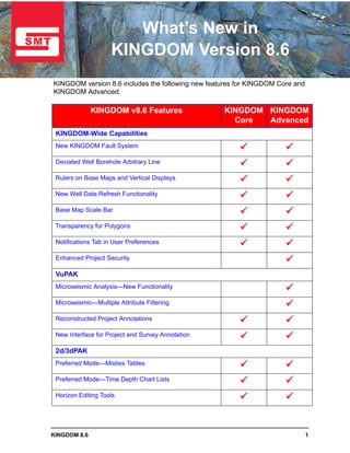
  • 1. What’s New in KINGDOM Version 8.6 KINGDOM version 8.6 includes the following new features for KINGDOM Core and KINGDOM Advanced. KINGDOM v8.6 Features KINGDOM KINGDOM Core Advanced KINGDOM-Wide Capabilities New KINGDOM Fault System Deviated Well Borehole Arbitrary Line Rulers on Base Maps and Vertical Displays New Well Data Refresh Functionality Base Map Scale Bar Transparency for Polygons Notifications Tab in User Preferences Enhanced Project Security VuPAK Microseismic Analysis—New Functionality Microseismic—Multiple Attribute Filtering Reconstructed Project Annotations New Interface for Project and Survey Annotation 2d/3dPAK Preferred Mode—Misties Tables Preferred Mode—Time Depth Chart Lists Horizon Editing Tools KINGDOM 8.6 1
  • 2. Horizon Editing Tool—Erase by Attribute Horizon Picking Tools Sync Report for Seismic Slice Volumes EarthPAK Display TVD (Reference Elevation) along Borehole Export Monthly and Cumulative Production Improved Authoring of Zones and Zone Attributes VelPAK Ease of Use Enhancements User Interface Enhancements Curve Tool Enhancements Workflow Tool Surface Tool Well Tool Learn more about KINGDOM through these resources on the SMT Web site: • Training Course Catalog • Getting Started Services • The KINGDOM Newsletter • Technical Webinars 2 KINGDOM 8.6
  • 3. KINGDOM-Wide Capabilities New KINGDOM Fault System Improved Technology for Better Faults The New Fault System is a complete redesign of the original fault system to provide a more accurate interpretation with new tools to modify fault surfaces. • A new triangulation engine provides better fault surfaces. • Fault smoothing using flex grid technology smooths one or all fault surfaces. • Fault polygons are created using the exact line of intersection between the fault and the horizon or grid. Fault polygons are calculated as the precise intersection between the horizon and the fault surface. The polygons can then be used for gridding and contouring. Fault polygons contain Z-values which assist in contouring around the faults. The New Fault System provides improved integration into 3D visualization in VuPAK. KINGDOM 8.6 3
  • 4. The fault smoothing tool allows the geoscientist to smooth one or all faults in a project with a single button click. Smoothing uses Flex Grid technology. Set the amount of smoothing to apply and create new, smoothed faults or replace existing faults. When required, additional smoothing automatically finds outliers and removes them from the interpretation. 4 KINGDOM 8.6
  • 5. New KINGDOM Fault System (con’t) Groundwork Set for Future Fault Enhancements The New Fault System contains additional capabilities that allow KINGDOM to expand fault enhancements into the future. • Better fit between segment and surface views. • Vertical separation as an attribute on the fault surface. • Dozens of additional enhancements. The red fault to the left shows both the surface and segment. The new fault system will create surfaces that fit the segments digitized on the VSD. New fault management tools simplify fault handling. New tools provide options to manipulate vertical separation. KINGDOM 8.6 5
  • 6. Deviated Well Borehole Arbitrary Line Create an Arbline along a Single, Deviated Well New functionality has been added to seismic arbitrary line creation. In order to faithfully represent the path of a deviated well through a structurally complex setting, this new functionality creates an arbitrary line that accurately follows the well path with a single click. • This new arbitrary line will be created automatically along a single deviated well borehole. • Users can select 'Single along One Deviated Borehole' from the usual list of arbitrary line methods, then click a deviated well symbol. • An arbitrary line will draw along the exact path of the well's deviation survey. • This new arbitrary line possesses the full capabilities of any Kingdom geologic or 3D surveys data based arbitrary line. 6 KINGDOM 8.6
  • 7. Rulers on Base Maps and Vertical Displays Measure Azimuth and Angle The geoscientist often needs a way to measure azimuth on a base map. This could be surface lineations on an air photo or a linear trend on a contoured map. KINGDOM now shows the Azimuth of a line digitized with the Base Map Ruler, referenced to either True North or Grid North. To meet the needs of the geologist who is geosteering a deviated well, as well as mapping structural trends, we have added a vertical display ruler that shows the Lateral Distance, Depth Shift and Dip or Inclination of a digitized line on a vertical display. KINGDOM 8.6 7
  • 8. New Well Data Refresh Functionality Refresh Wells from the Database Multiple options to easily refresh wells from the database are provided, allowing users in multi-user project environments to keep their data in sync without disrupting their workflows. • Right-click a well symbol to refresh a well from the database. • Right-click a well subset in the Project Tree to refresh the wells in the subset from the database. The subset can be dynamic or static. • Right-click a base map to refresh the visible wells from the database. 8 KINGDOM 8.6
  • 9. Right-click to Add a Well to the Base Map Improved Well Planning In order to streamline well planning we have added the ability to right-click on a base map to add a new well location. This saves time when designing an exploitation program. • Right-click on base map to add a well. The Well Edit dialog box is pre-populated with the X and Y locations of the point selected on the base map. • All that needs to be added is a UWI, Reference elevation and Start and End depths. Right-click on the location for the proposed well on the Base Map and select Wells > Add Well at Current Location. Cross-section through 2 wells as displayed on the Base Map The new well is displayed on the Base Map in the designated location. Surface location XY coordinates are populated in the Well Edit dialog. A new cross section through wells now includes 3 wells. KINGDOM 8.6 9
  • 10. Base Map Scale Bar Movable, Resizable Scale Information Scale bars may now be displayed in map views. • Selecting “Show Scale Bar” places a scale bar on the map. • This scale bar may be resized and moved to display anywhere within the visible map frame. • Windows copied into presentation documents can now easily convey scale information. Specify the height of the Scale Bar and customize the text attributes from the Scale tab in Settings. 10 KINGDOM 8.6
  • 11. Transparency for Polygons Added Flexibility when Working with Polygons New adjustable transparency slider controls provide more flexibility in the usage of polygons. Adjust the transparency of the polygon with the slider. For correlation polygons, stretch and squeeze the polygon with ‘+’ and ‘-’ respectively. Correlation polygon transparency provides more precise correlation. This works with raster logs too! Transparency option is also Leverage adjustable transparency for correlation polygons on seismic VSD’s for improved jump correlations. available for planimeter polygons. KINGDOM 8.6 11
  • 12. Hide/Show Location Rulers Maximize your Interpretation Pallet •Right-click on a ruler on a cross section or VSD to hide the location rulers. •Work in maximized interpretation pallet. • Turn on the location rulers from View>Toolbars when desired. Notifications Tab in User Preferences Manage Well and Database Notifications in User Preferences • Turn of or off notification that new wells have been added to a project since last login when in author preferred time-depth chart mode. • Turn on or off database notifications: - Prompt for project database conversion from MS Access to SQL, SQL Server Express, or Oracle - Option to change SQL Server Express from Manual to Auto portability configuration - Notification when exiting an Auto SSE project that another user is still in the project. The project database cannot automatically detach and become portable until all authors are out of the project. 12 KINGDOM 8.6
  • 13. Enhanced Project Security Providing administrators the ability to set project level security in Oracle and SQL Server environments Security Levels • Administrator New!—Access and manage security settings. • All Authors—Allows users to select or switch to any author when they open a project. • Specific Authors New!—Allows a project administrator to assign one or more specific authors to a given windows user. • Work Tree Only—Restricts a named user to the context of an author/Work Tree combination within a project. • No Access—Completely restricts user from accessing a KINGDOM project. Set default access level for all users not specifically listed Sort or Filter the Effective Permissions table to easily review and update user access Set access level for each user if different from default Search Active Directory for valid windows users and assign specific permissions KINGDOM 8.6 13
  • 14. VuPAK Microseismic Analysis—New Functionality • Load Microseismic data. - Supports known contractor formats for microseismic event data and fracture treatment curves. - Stores data with project. - Provides attribute scaling & adjustment options. • Visualize data as part of regular interpretation: - View microseismic data on all displays. - Display in depth and time simultaneously. - Control size and color based on Microseismic Event (MSE) attributes in all views. • Analyze using MSE and fracture treatment curves: - Apply multiple attribute filters. - Animate based on fracture event timeline. - Manually select MSE points in any of the 2D or 3D views. - Save interesting trends and events as subsets. 14 KINGDOM 8.6
  • 15. Microseismic—Management Console • Control color based on any Microseismic attribute using existing SMT color bars. • Control size based on any Microseismic attribute: - Specify range for small to large event display. - Show constant size—and vary from small to large. - Control individual size and display for 2d and 3d views. • Visualize in both time and depth views at the same time. - Create Z-Time attribute with user selected T/D curve. Select the views for your Display on microseismic display. the Base Map too. Display in both time and depth in a VSD and VuPAK. KINGDOM 8.6 15
  • 16. Microseismic—Multiple Attribute Filtering • Filter using fracture job time: - Display treatment curves. - Display filtered Microseismic. • Filter using Microseismic events: - Choose attributes to filter on. - Use more than one attribute. - Build an “and” query for multiple attribute filtering. - Include fracture job time. • Filter using manual selection. - Select points on 2d views using digitize polygon capability. - Select points in VuPAK and 3d crossplot using a lasso. • Cut or crop selected points. • Save visible points as a subset for later interpretation. Lasso points to cut or crop. Filter points by the range of treatment data displayed on the 2D Crossplot. Points on all views update dynamically as you filter and select. 16 KINGDOM 8.6
  • 17. Easy Launch and Display Option VuPAK can be quickly launched by selecting a fault, horizon, or grid from any view. • VuPAK is launched and automatically scaled to optimally display the object, significantly enhancing the interpretation workflow. Easy right click select displays horizons, grids, faults, inlines, crosslines, 2d lines, and arb lines. Right click on an object in the Base Map or in a VSD and select to display the object in VuPAK. Reconstructed Project Annotations Multiple adjustments to VuPAK annotations improve visibility, usability, and presentation. • Default 3D view is changed from orthographic to perspective. • Project cube annotations no longer block the 3D view. • Annotation is rendered only along the back faces of the cube. • Allows two or more annotations to not overlap. • Default settings for survey annotations based on survey intervals. KINGDOM 8.6 17
  • 18. New Interface for Project and Survey Annotation New user interface manages both Project and Survey annotation and a single click will take the viewer into a presentation mode. • Click one button to access all annotation settings • One click to show/hide all annotations from the toolbar or from within the annotation settings dialog box. • Each user can have their own annotation settings. • Survey annotations in VuPAK are independent from survey annotation settings in KINGDOM. 18 KINGDOM 8.6
  • 19. Transparency of Slices and Faults The ability to manipulate transparency of slices and faults together has been improved. Fault surface and intersecting seismic displays with transparency for each object set to 0. Increased transparency settings for all objects. Adjust Fault transparency with slider. KINGDOM 8.6 19
  • 20. 2d/3dPAK Preferred Mode—Misties Tables Author Specific Mistie Settings The Preferred Mistie mode allows all authors to concurrently work with their own customized mistie settings. • Each author’s mistie settings are maintained at all times until a change is desired. • When mistie changes are made, only the author making the change will see the effect on their seismic data. • Mistie settings are saved and reloaded on a per author basis. • All authors can log out and return to the same mistie settings when they log back in. • Return to Project Mistie mode at any time through Project Management. • When in Project Mistie mode, all users will work with a common set of mistie settings. 20 KINGDOM 8.6
  • 21. Preferred Mode—Time Depth Chart Lists Author Specific well and Time-Depth Chart Associations Active time-depth chart lists are supported in an Author Preferred or Project mode, providing more flexibility in multi-user project environments. • Preferred mode allows each project author to maintain and utilize his own well and active time-depth chart associations. • Project mode allows for all project authors to use the same well and active time-depth chart associations, so all authors can be in sync with each other if necessary. Switch between Preferred and Project mode through Project Management. Each author is informed of this option when logging in to a project for the first time. • The preferred mode can be switched at any time, so that depending on the stage of the project, authors can chose to be in sync with each other or use their individual time-depth associations. • All authors are notified if the mode is changed in the project, so they are aware that the active Time-Depth charts may have changed. The author that made this change is also included in the message. KINGDOM 8.6 21
  • 22. Horizon Editing Tools New Horizon Editing tools include Horizon Smoothing and Horizon Interpolation. The improved functionality provides more flexibility during horizon interpretation and provides a New Pick Status for Smoothed and Interpolated Picks. • New menu structure provides easier access to Polygon Erase, Polygon Smooth, and Polygon Interpolate. • Editing can be performed on the active horizon or an automatically created copy, so that users can always have a backup copy of a horizon. Horizon Smoothing Smoothing options provide more flexibility and QC tools for an interpreter. • Manual picks can be preserved during smoothing. • Smoothing can be applied to inside or outside polygon area. • Convenient undo/redo buttons improve usability. 22 KINGDOM 8.6
  • 23. Horizon Interpolation The Horizon Interpolation tool uses a quick and effective flex grid algorithm to infill gaps in picked horizons. • Area can be constrained by a fault polygon set. • Works with named or digitized polygons, inside or outside of a polygon area. • Automatically extracts selected data types at the new points. • Streamlines the interpretation workflow in areas of low quality data. Initial picks along inlines and crosslines of 3D survey. Use the Interpolate tool to infill the initial picks using the flex grid algorithm. The Interpolate function extracts a selected data type at the newly created horizon points. KINGDOM 8.6 23
  • 24. New Pick Status for Smoothed and Interpolated Picks The Pick Status attribute displays the area in the center of the horizon that was smoothed. After picking on the inlines and crosslines, the horizon was infilled with the Interpolation tool. The Flex Grid algorithm was used for the interpolation. Horizon Picking Tools • 2d Hunt and 2d Seeker+ will now stop at Unassigned fault segments. • Horizon interpretation can then be done effectively before the final fault surfaces are created. • Multilevel undo and redo operations are supported when picking on a flattened horizon with 2d picking types, so that picking can be easily corrected. Undo and redo buttons conveniently accessed from Horizon Editing dialog 24 KINGDOM 8.6
  • 25. Horizon Editing Tool—Erase by Attribute Now horizons picked with 3D Seeker/+ algorithms can be easily edited and re-picked. Users can preview the effects of the edit before applying. • Based on Confidence and Pick order data provided with 3D Seeker/+ picked horizons. • Can be applied to the outside or inside area of a named polygon. • Erase by Attribute is always applied to z picks on the active horizon. Edits are controlled by value sliders, allowing users to preview the changes before committing the edits. • Users can see and approve the erase settings before the actual erase is applied. • Low confidence and/or high pick order picks can be erased, so that the horizon can be picked again in those areas with different picking parameters. • The Pick Order control can be used as a playback to see the horizon picking history. KINGDOM 8.6 25
  • 26. Sync Report for Seismic Slice Volumes An in-sync phase option for slice data is offered in 8.6 that can be used when workflows require accuracy over performance. • Using this option will ensure slice data displayed will always be in-sync with the phase setting of the parent trace volume. • The option can be set on the Slices tab of Select Data to Display dialog box. • Create slice displays on-the-fly if the current slice phase setting is different from the data type's vertical trace volume, OR set the option to always use existing slice data for improved performance. • Select whether notification is given when slice data is out of sync with phase setting of vertical trace display. 26 KINGDOM 8.6
  • 27. The Report shows phase information when slice volume phase setting differs from phase of vertical trace displays. When slice data phase does not match current trace display, options are: 1. Use existing slice data for fast performance, OR 2. generate slice displays on-the-fly to ensure phase match accuracy. KINGDOM 8.6 27
  • 28. EarthPAK Display TVD (Reference Elevation) along Borehole New Log Setting option enables posting of either subsea or TVD Well Reference Elevation along the borehole in a cross section or arbline. 28 KINGDOM 8.6
  • 29. In the Vertical Scale Settings, select Depth type as Subsea or TVD Reference Elevation. This choice will be displayed when specifying your Log Settings. In Log Settings your depth type choice will be available for display along the borehole. . Subsea or TVD Well Reference Elevation values are displayed along with the measured depth values in your cross section or arbline. KINGDOM 8.6 29
  • 30. Export Monthly and Cumulative Production KINGDOM now supports the exporting of production data.The export can be in fixed width, tab delimited or comma delimited. Select Wells > Export. Well Production Data is available as a data type. File can be exported with the delimiter of your choice. Improved Authoring of Zones and Zone Attributes A new enhancement improves and clarifies the authorship of zones and zone attributes. • Zones and zone attributes can now be copied between authors. • When selecting data for the Wells Spreadsheet, select which author’s zones you want to display. 30 KINGDOM 8.6
  • 31. VelPAK Ease of Use Enhancements VelPAK incorporates a wide range of enhancements and new features that enable the user to be more productive with the software. These are detailed in the following pages. These enhancements have necessitated a change in the model file format. If you have a model created in an earlier version of VelPAK, this model file can be opened in VelPAK 8.6. However, model files saved in VelPAK 8.6 can only be opened in version 8.6 or later of VelPAK. Model files saved in VelPAK 8.6 are by default saved in a different location than earlier versions, but exercise caution to avoid accidentally over-writing older models you may wish to keep. Existing workflows are similarly forwards compatible, and will not be overwritten when saved in the new default location. The storage of VelPAK data in the project Only wells active in folder has also been revised to give the user the project tree are greater flexibility when customizing their loaded into the model workflows. When a model is saved, a new by default. folder tree is created automatically for that model. The root of the folder tree is in the project author folder, and model data is then stored under the ‘velpak’ folder. This new folder organization enables the user to customize workflows and Folder parameters for each layer independently, hierarchy for without having to worry whether the VelPAK workflow changes will affect any other layer. model data. Each event in the model that has been used in a workflow will also have a folder under the name of the model as event number, which contains the workflow components and parameters stored for that event alone. For example, the user may wish to use a different gridding algorithm for his residual error correction in one event that contains less well data than shallower event. He can adapt the standard workflow and save it just for that event, knowing shallower events will remain as they were. KINGDOM 8.6 31
  • 32. User Interface Enhancements A range of user interface improvements have been made to enable faster and more accurate navigation of the interface. Each tool now has new and consistent use of icons for ‘Previous’ and ‘Next’ event, well and line options where appropriate. Property grid fly-outs have changed to allow a more concise, clearer view of the parameters, hiding or deactivating unnecessary parameters. This allows the user to quickly focus on just which parameters need to be changed. Tool tip styling and information has been unified across modules The new ‘Abort’ button now will interrupt compute intensive processes such as workflows and gridding Curve Tool Enhancements The Curve tool is used to analyze and compare any data loaded into the VelPAK model. • The user may now determine a level of confidence in a linear regression analysis by specifying a confidence percent and toggling on confidence bands in the ‘Display’ fly-out. These bands are saved per event in the new model folder tree. • For clearer reporting, users can now define their own axis titles for the display, and there is convenient option to quickly flip the X and Y range axis minimum and maximum values. 32 KINGDOM 8.6
  • 33. Curve Tool Enhancements (cont’d) • Graphing performance has been improved significantly for data sets with many thousands of samples. The following figure illustrates the Regression Curve and Graph enhancements: The Data Tab contains tabulated data for the graph display. • The export of tables from Data Tabs now support the Microsoft .xlsx spreadsheet format. • The table column contents can be summarized using the Summary (sigma) icon in the column header. KINGDOM 8.6 33
  • 34. Workflow Tool • The arrangement of workflows has been changed from a long list to a more organized tree structure, allowing the user to quickly find components for incorporation into their own workflows, or to test different methods for depth conversion, gridding, data display etc. • The workflows and components used prior to KINGDOM 8.6 are stored under the ‘Kingdom 85 Workflows’ folder and still behave in the same way. • There are new workflow nodes: branch, loop, pin, seed, image, check and repaint, and sample workflows for the new user too examine and use as a template for their own workflows. • For quicker editing of workflows, the user can right-click on a node, which now has two extra options on the popup menu: toggle options to allow resize and edit of the node title. • Workflow nodes now feature inheritance with an over-ride facility to allow only selected parameters in the model to be changed. Toggling on the new 'Watch Sublevel Execution' icon allows the user to see each node of a collapsed workflow highlighted as it is executed Surface Tool Grids in VelPAK are created and manipulated in the Surface tool. New gridding options and performance enhancements have been made. • New gridding methods ‘Simple Kriging’ and ‘Sequential Gaussian Simulation Kriging’ have been added. • Kriging time has been significantly reduced. • The ‘Process’ fly-out now contains the ‘Move Grid’ formula, which enables the user to move a grid from one slot to another without using Copy/Paste. 34 KINGDOM 8.6
  • 35. Surface Tool (cont’d) Further improvements to the Surface tool include the following: • To improve gridding speed, which is significant for many layered depth conversions, there is a new decimation option (the ‘Increment Factor’) in the gridding parameters fly-out. Simple Kriging SGS Kriging Control point (XYZ) data can also be copied, deleted and concatenated (merged) using the ‘Type’ operation in the XYZ fly-out. This will allow users to perform sophisticated data management within a workflow. An addition to depth conversion techniques, the ‘Interval Velocity versus Isochron’ method, is now available as a standard Optimize method in the ‘Depth > Parameters > Formula’ options. KINGDOM 8.6 35
  • 36. Well Tool For more convenient verification of the depth conversion, the residual error computation made in the well tool ‘Tie’ now computes misties between both the formation top and time-to-depth converted grid and the formation top and current depth grid. These errors are stored separately in the XYZ folder of the model tree. This enables the user to evaluate the error between the current depth conversion method and an existing depth grid. The ‘Tie’ fly-out has also been simplified with redundant options removed. 36 KINGDOM 8.6