1. Introduction
Stormwater
Stormwater is rain or melted snow that has fall into the ground. This water either is absorbed
by plantation, evaporates or runs off the land into storm sewers, streams and lakes.
("Stormwater Management - Ministry of the Environment.")
Stormwater Management
Stormwater management involves the control of that surface runoff. The volume and rate of
runoff both substantially increase as land development occurs. Construction of impervious
surfaces, such as pavement roads, and the installation of storm sewer pipes which efficiently
collect and discharge runoff, prevent the infiltration of rainfall into the soil.
( "Stormwater
Management - Ministry of the Environment.")
The Importance of Stormwater Management
Stormwater management prevents physical damage to persons and property from flooding,
and also prevents polluted runoff from negatively impacting local waterways .(
"Stormwater
Management - Ministry of the Environment.")
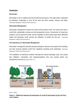
The installation of impervious surfaces interrupts the natural hydrologic cycle, and causes
less infiltration, interception and evapotranspiration than was present before any
development occurred.(Stormwater FAQs. n.d..)
(Source, TRCA)
Figure 1 : Difference between the absorption & runoff of stormwater by the soil from
now & before.
2. Therefore, the volume and rate of flow of stormwater produced by the land surface have
been greatly increased. This result contributes to flooding, sediment deposition, erosion and
so on.(Stormwater FAQs. (n.d.)
Benefits
Stormwater should be considered a resource that provides benefits such as groundwater
recharge, which maintains flows in streams.
Stormwater management also (Sustainable Cities Institute: Stormwater Runoff. (n.d)
Reduces the frequency and severity of flooding
Minimizes or avoids the creation of polluted stormwater
Reduces environmental impacts on the lakes, rivers and watersheds
Maintain the natural hydrologic cycle
Minimizes health risks
Purposes of using Stormwater Management
Stormwater is the number one cause of water pollution. In most cases, stormwater either
does not receive any treatment before it enters our waterways or is inadequately treated.
(Sustainable Cities Institute: Stormwater Runoff. (n.d )
Polluted water creates numerous costs to the public and to wildlife. Communities that use
surface water for their drinking supply must pay much more to clean up polluted water than
clean water. (Sustainable Cities Institute: Stormwater Runoff. (n.d)
Polluted water hurts the wildlife in creeks, streams, rivers and lakes. Dirt from erosion, also
called sediment, covers up fish habitats and fertilizers can cause too much algae to grow,
which also hurts wildlife by using up the oxygen they need to survive.
(Sustainable Cities Institute:
Stormwater Runoff. (n.d)
The quantity of stormwater is also a problem. When stormwater falls on hard surfaces like
roads, roofs, driveways and parking lots, it cannot seep into the ground, so it runs off to
lower areas. The high volume of water causes streams banks erode and washes the wildlife
that live their downstream.( Sustainable Cities Institute: Stormwater Runoff. (n.d)
3. Flood Management
Flood management refers to prevention, control and maintenance. Administrative
organisations such as local authorities, state government, flood prevention team and also
national and regional public organisations share this responsibility together. The main
purpose of flood management is to come out with an immediate flood relief solution so that
the flood mitigation projects are not far left behind due to rapid urban development.
Flood managements are divided into two types including structural and non-structural
methods in which the structural refers to flood mitigation project whereas the non-structural
approach refers to solutions under Urban Storm Water Management Manual (MSMA).
(Nahrim.gov.my, 2013)
In order to acquire a balance between structural and non-structural
measures, Integrated River Basin Development (IRBM) and the Integrated Flood
Management (IFM) approaches is adopted. (Nahrim.gov.my, 2013)
One of the ways of flood management is using the flood hazard map which is a risk
assessment tool providing the information to evaluate the surroundings so that the adverse
impacts of the floods can be reduced.
Management (IFM).
(Nahrim.gov.my, 2013)
(Nahrim.gov.my, 2013)
Next is the Integrated Flood
It refers to maximise of the efficient use of flood plain
and minimise of damages caused by flood. Here, both are considered of great importance.
The principle of IFM is to live with flood which means flood is to be treated as part of the
water cycle in which land and water management has to be integrated at the same time
enable participation and cooperation between different agencies.
4. BatuJinjang Ponds & Related Diversions Project
Installation
For both installation in Sungai Keroh and Sungai Gombak is quite similar. A barrage
is constructed across Sungai Keroh and Sungai Gombak to increase the depth of the river
and prevent the flood from happening
(MOHD FAUZI MOHAMAD, 2013).
Inlet and outlet gate are
constructed in order to keep the water storage in the pond within the pond’s maximum
storage level and allow the flowing system from the diversion into the detention pond
FAUZI MOHAMAD, 2013).
(MOHD
Control gate is installed to control the flow of storm water from pond into
Sungai Batu and Sungai Jinjang when the flood situation in river is being subsided
(Web10.bernama, 2013).
Flood walls also constructed along the whole Sungai Gombak and
Sungai Keroh to temporarily contain the water of river which maybe rise to an unusual level
during downpour (Slideshare, 2013).
The discharge capacity of Gombak Diversion channel is being upgraded and
enlarged
(Water.gov, 2013).The
previous Gombak Diversion only has 60 cubic meters per
second while the new one has 275 cubic meters per second
(Water.gov, 2013).Besides
that,
storage capacity ofBatu Detention Pond also being enlarged to 4.5 million cubic meters
(Slideshare, 2013).
Gombak Diversion has a 3.375km, 26m wide and 4m deep channel to divert
away the storm water (Water.gov, 2013).
Keroh Diversion Channel is combination of closed and open channels. The closed
channels are constructed in order to compensate the existing services and minimising the
land acquisition required (Water.gov, 2013).
A bund is being constructed along both side of Sungai Muda to prevent the
inundation from river
(Wikipedia, 2013).
larger discharge capacity
Sungai Muda is also deepened and widens to have
(Water.gov, 2013).
A better drainage systems and flood control gate
are also installed in Sungai Muda(Water.gov, 2013). There is a floodwater control barriers, pump
house, quarters and riverbank protection structure all being installed at the upstream and the
downstream of the Sungai Muda(Web10.bernama, 2013).
( Internet,Slideshare)
Figure 2: Direction of flow of storm water in Gombak Diversion
and Keroh Diversion
5. Process
Flood often occurs in Kuala Lumpur because it is located near to the confluence of
Sungai Klang and Sungai Gombak
(Saw HinSeang, n.d).
So the government had decided to run a
project in order to improve this situation which was the BatuJinjang Ponds and Relevant
Diversion project. This project started its work from 25th August 2003 and completed on year
2009. It is aimed to improve the flooding problems by regulating the storm water from the
north western catchment which is Sungai Gombak and Sungai Jinjang(nre, 2013). The project
of BatuJinjang ponds and diversions had cost about RM528 million
(Nst, 2013).In
this project,
excessive storm water is stored into the ex-mining ponds when there is downpour
(Web10.bernama, 2013).
This project manages to construct two flood diversion channels, one begins from
Sungai Gombak to Sungai Batu, while another begins from Sungai Keroh to Sungai
Jinjang(Web10.bernama,
2013).
The rainwater is diverted from Sungai Keroh to Sungai Jinjang
detention ponds. While diversion channel of Sungai Gombak is upgraded to have a larger
discharge capacity to flow the rainwater to the enlarged Sungai Batu detention pond
2013).How
(Water.gov,
does this system work?
The Gombak diversion is 3.75km long, 26m wide and 4m deep
(Water.gov, 2013).
When
downpour is detected in Gombak Diversion, it will stimulate a sequence of gate operations to
divert floodwater away from Kuala Lumpur city to the detention pond of Sungai Batu(Water.gov,
2013).
There is a barrage located at the Gombak River downstream of Gombak Diversion
(Slideshare.net, 2013).
The function of Gombak barrage is to increase the depth of the river and
prevent the flood from occurring
(Wikipedia, 2013).
Gombak Diversion Channel has 275 cubic
meters per seconds of flowing capacity, while the Batu Pond has 4.5million cubic meters of
storage capacity to store the storm water (Water.gov, 2013).
First, the overflow of rainwater is diverted from Sungai Gombak to Gombak
Diversion
(Slideshare.net, 2013).
Then there is an inlet and outlet gate located at the Gombak
Diversion to control the amount of rainwater flow into Batu Pond detention
MOHAMAD, 2013).
(MOHD FAUZI
A control gate will control the flow of rainwater from Batu Pond detention to
Sungai Batu when the flood situation in Sungai Batu is subsided (Web10.bernama, 2013).
Keroh Diversion is quite similar to Gombak Diversion. It has similar sequence of gate
operations and will be stimulated when overflow rainwater is detected too
(Water.gov, 2013).
The
stormwater will be diverted away from Kuala Lumpur towards Sungai Keroh first. Then from
Sungai Keroh, water flows into Keroh Diversion Channel which is 2.2 kilometres long and
has 100 cubic meters per second of discharge capacity
(Slideshare.net, 2013).Stormwater
is then
6. stored in Jinjang Ponds which consist of Nanyang pond, Wahyu and Delima(Water.gov, 2013).
This combined Jinjang Ponds has a 2.5 million cubic meters of storage capacity
2013).
(Water.gov,
There are two control gates which are respectively located at Nanyang Pond outlet and
Taman Wahyu and Delima Pond outlet to discharge the rainwater into Sungai
Jinjang(Slideshare.net, 2013).
On another hand, there is another flood mitigation project for the Sungai Muda.
Sungai Muda is positioned within the boundary of Kedah and Pulau Pinang
(Water.gov, 2013).
Sungai Muda almost experienced flood every year. Sungai Muda is the longest river in
Malaysia and used to supply water for the agricultural, industrial and domestic area in
Penang and Kedah (Wikipedia, 2013). It has a catchment area about 4210 kilometres square and
has a river channel which is 180 kilometres from the river mouth to the Muda dam (N.d, n.d).
The rainwater flow from upstream into downstream of Sungai Muda. A bund is
constructed along both side of Sungai Muda to store the storm water and prevent the protect
Pulau Pinang from flooding (n.d, n.d).
stormwater--- diverted to Sg. Gombak --- Gombak Diversion --- Batu Pond Detention --- Sg.
Batu
Gombak Diversion Channel
stormwater --- diverted from KL --- Sg. Keroh --- Keroh Diversion Channel --- Jinjang Ponds -- Sg. Jinjang
Installation
Keroh Diversion Channel
7. Bertam - Kepala Batas Flood Mitigation Project
Installation
It is located at the northern part of SeberangPerai District in Penang covering the Kepala
Batas town, LadangBertam, Lahar IkanMati and Kg. TokBedu.
(Water.gov.my. 2013).
The northern
part of SeberangPerai, being the core of this region is often affected by floods yearly
especially around April to May and September to November as this is the time when the
weather is seriously affected by the monsoon season. It is mainly designed to mitigate flood
at Bertam-Kepala Batas area and to improve the drainage capacity in both main and internal
drainage system.
Mostly affected places includes Kepala Batas town, LadangBertam, Lahar IkanMati and Kg.
TokBedu which cover a total area of approximately 44.30 Km². Total losses due to flood is
estimated in the figure of RM 0.5 million to RM 2.0 million yearly.
(Water.gov.my. 2013)
Due to the
rapid development of the town, factories and industrial areas had an obvious increase but
one side of the development had exceed the balance as management process or
maintenance work are being left behind. This is clearly shown in cases where industrial
areas’ drainage system is not capable of dealing with spills causing direct flow to the
drainage system. The insufficient discharge capacity of main outlet drainage system and
increase water runoff due to development had pushed this problem to a critical level.
Most of the lands in Bertam are used for agriculture purpose and this is why most
development of the drainage system here are designed to suit only agricultural water
management and the rapid development in this area had caused this former main outlet
drainage system no more longer sufficient and adequate to deal with this problem. Therefore,
capacity of both main drainage system and internal drainage system has to be increased in
order to be capable of conveying storm water away from the flooding area.
Process
In order to cope with the storm water runoff, rivers and drainage system around that area is
being observed and analysed. Later, the rivers and drainage systems are to be upgraded,
including widening of the rivers, maintenance and repair of existing drainage system also
construction of new drainage system to increase drainage capacity of storm water runoff.
Retention ponds are also constructed and drainage pumping system is installed for
continuous flow of storm water. Outlet channels, river gates, bridges and bunds are also
constructed
for
more
effective
diverting
of
storm
water
runoff.
8. Multimedia Super Corridor (MSC) Flood Mitigation Project
Installation
The Multimedia Super Corridor (MSC) has a length of 50km long and 15km width. It extends
southwards from KLCC and it has eight subdivisions of planning areas including the
Putrajaya, Airport City, Cyberjaya, Cyber village, Tele-Suburbs, Research and Development
Centre, High-Tech Parks and ends at KLIA. (Water.gov.my. 2013)
Therefore, below the Multimedia Super Corridor (MSC) is a well-planned overall drainage
system is designed to avert flooding problems. Before construction, the Macro Drainage
Master Plan Study was carried out so that all existing drainage system and drainage
proposals from other developers are to be reviewed. Analysis is being carried out to design a
proper drainage system to suit the area beneath the Multimedia Super Corridor. For example,
area near critical rivers need drainage corridor reserves and flood level for development
immediately. Sediment problems due to sand mining activities which will affect the
environment around the Multimedia Super Corridor and the runoff control of storm water at
source are also included in this study. This study also provides engineers with a thorough
comprehension regarding the site before the construction.
As the Macro Drainage Master Plan is to be implemented in phases involving large volume
of work, the Immediate Action Plan (IAP) was identified to be an important step for that
moment. In this project, the IAP Implementation has to be carried out with the Sungai Klang
flood mitigation at the same time in order to shorten the period of this implementation despite
all of these are carried out downstream which is considered a tough and time consuming
work.
Process
The process of storm water management is the control of hydrological cycle including
conveyance and storage of storm water. As mentioned above the Macro Drainage Master
Plan Study will comprehensively examined the adequacy of the existing drainage systems
and develop a short to long term drainage improvement measures to meet the current
standards and the future needs. Drainage improvement methods includes using more
durable material in construction of drainage pipes, a more systematic and understandable
plan of drainage pipes design, the connection of the water pipes and the consistent
maintenance work which needed to be carried out under guided supervision. All storm water
is diverted through the well-designed drainage system underneath the Multimedia Super
Corridor. This long connection has the sufficient capability to divert away storm water in an
effective and efficient way.
9. Problems
1. Flooding
Flood is an overflow of water which occurs on a dry land during rainy days. Its occurs
as solid surfaces replace natural vegetation because water is unable to slowly filter
into the landscape. The changes in land have major effect on quantity and quality of
stormwater runoff. The improper planned and managed can dramatically alter the
natural hydrology of an area as it increases impervious cover which decreases the
amount of rainwater that can actually infiltrate into the soil and then increases the
volume and rate of stormwater runoff. (Carson, n.d)
2. Pollution
Water pollution causes the soil erosion and pollution of rivers as the flowing of the
water brings pollutants together with it into the waterways.Spillage of oil due to
industrial activities, pesticides from agricultural activities, toxins and chemicals from
the factories and also sediments and soil particles brought together with the
rainwater are all deposited into the water distribution system. This runoff of polluted
stormwater will cause the death of aquatic life and make waterways unhealthy place
to live, work, play. This untreated stormwater will result in contamination of drinking
water supplies. It also destructs the habitat of flora and fauna, affects the equilibrium
of the ecosystem, cause hazards to human health and pollution to our mother nature.
As this situation aggravates, the water distribution system is seriously affected and
consequently this will increase floods rates.(Carson, n.d)
10. Solutions
1. Floodway
Town of Cedar Lake,n.d)
Figure 4: Floodway used by stormwater management
Floodway is a flood control method which used to decrease the detrimental effects of
flood waters. This includes the channel of water to a river, stream, lake and area
adjacent to the channel that will transmit moving water during flood. Therefore, this is
a high danger portion of the floodplain which brings hazard to residents and also
personnel.(Town of Cedar Lake,n.d)
2. Flood warning system
(Drainage Services Department, 2009)
Figure 5: Schematic of flood layout system.
Flood warning systems help to minimize flood when the flood water reaches a certain
level of height level. This warning would disseminate through flood sirens or through
automatic telephone calls to the residential area nearby. Flood shelters are prepared
during emergencies to supply an adequate safety for the residents who affected by
flood. (Drainage Services Department, 2009)
11. 3. Erosion control
("Erosion / sediment control," )
Figure 6: Ways of erosion control
Erosion control is the management and controlling process where the wind and water
is at a state under controlled to prevent it from causing disturbance to development in
construction of both agriculture and industrial area. This is used in natural and urban
areas which often control stormwater runoff management programs that are required
by governments. Erosion control includes temporary seeding, temporary mulching,
permanent sodding, temporary or permanent erosion control blankets and permanent
vegetative buffer strips. ("Erosion / sediment control," )
12. 4. Smart Tunnel
(MacDonald, 2012)
Figure 7: Dual purpose smart tunnel in either divert water and control traffic
Smart Tunnel is a solution to the Malaysian capital’s long-term traffic and storm water
management problems. This dual purpose tunnel will divert floodwaters away from
the confluence of the two major rivers running through the city centre.(MacDonald, 2012)
5. Retarding basin and control basin
Flood retarding basins (detention storages or compensating basins) are holding
basins which temporarily store storm water to reduce downstream flow rates. Control
basin is a small earthen ridge-and-channel or embankment built across which is
perpendicular to a small watercourse or area of concentrated flow within a field.
Agricultural runoff water and sediment are trapped as it flows down the
watercourse.(Minnesota Department of Agriculture (MDA), 2013)
13. Recommendations
1. Living roof
Living roofs are a water sensitive design (WSD) technology which is used to describe
a substrate and vegetation on covered roof. This will give advantages in stormwater
management which acts as source control to prevent runoff generation from
impervious areas and also provide stormwater management opportunity in unused
space.
(Auckland Council, 2013)
It will also help to retain and slow rainwater runoff on tops
of the roofs.
(Jessica, 2012)
Figure 8: Living pitched roof used for stormwater management
( County Flat Roofing (UK) Ltd , 2012)
Figure 9: Living flat roof used for stormwater management
14. 2. Rain garden
Rain garden is one filtration features that can be easily installed in the garden by
property owners in their own backyards. It is basically a depression on the ground
into which rainwater is channeled to be slowly absorbed by the ground acting as a
pervious surface. This can reduce the volume of storm water that flows to natural
water bodies which provide a catchment area for rainwater.
(Tunas, 2013)
(Tunas, 2013)
Figure 10: Rain garden used for stormwater management
3. Rainwater harvesting
Rainwater harvesting is the process of collecting, storing and distributing rainwater
from the roof. The lightweight and high compressive strength Flo-Tank are fixed
underground provides greater useable ground area and enhanced aesthetic setting
compared to traditional above ground tanks. Besides that, it also makes the
installation quicker, safer, easier and cheaper than round or oval plastic tanks below
ground. ("Complete storm water," )
. ("Complete storm water," )
Figure 11: Process of rain water harvesting
15. Learning From Group Work Project
Chia KhaiYuean (0314368)
Through this assignment, I gained a lot of knowledge about our SMART Tunnel since I am
doing the case study. The SMART Tunnel is a Malaysian pride. It makes Malaysia pride and
and it really makes me feel proud to be a MALAYSIAN. Besides that, I also learned how to
do a case study. I struggled for it at first as I have no idea at all about what a case study is
and I feel really pressure because case study contributes almost one-third of the assignment
marks. However, I am proud to say that I managed to strive through all the problems I
encountered and I have pride in the job I’ve done.
Chin Wei Sun (0314369)
I am having the storm water management for my building service 1 group project. Miss Liza
had assigned us into 5 people a group. I am delighted to have Chia KhaiYuean, Yap Hue
Eng, Jenny Wong Yen Li and Yap ZhiXin as my group members. In this assignment I
learned a lot of things that I never expected before. For example, I learned how to do a case
study in an assignment, making video for presentation and many more others. Besides that,
through this group work, I know the importance of toleration and corporation in order to get
the works went smooth. My group members gave me a lot of support and help when I met
problems during the process of searching information for the assignment. It was my pleasure
to have them as my group members.
Jenny Wong Yen Li (0314518)
First of all, I have no idea what is stormwater management before doing this assignment. I
have done quite a lot of research regarding on this assignment. Other than doing research,
we also did group discussions. Now I knew that stormwater management not only could
maintain the natural hydrologic cycle, it could also reduce the risk of flooding. After all
researches and discussions, I finally realised how important is stormwater management.
16. Yap Hue Eng (0314857)
Through this assignment, I gained knowledge on this topic about storm water management
and finally knew how our country copes with these kinds of problems. Apparently this topic is
not an easy topic at all. There is also not much information related to this topic but my group
members and I are able to go through all these and finished our assignment at the end. I
was glad also to have my group members with me together. Everything went on smoothly
during the discussing process, job assigning process, grouping information process and
implement process. With my group members, I can feel the cooperation between us. We
helped each other and share useful information together. We have our brainstorming and
discussion together. The most important lesson I had learnt through this assignment is about
time management. I learnt to gather information in advance and go through the useful
information in order to gain a better understanding on the topic given. I was really amazed
when our group are able to complete this assignment even before the deadline. Hence, time
management is truly something I have to remind myself from time to time so that I am able to
complete all my assignments on time.
Yap ZhiXin (0314542)
I am very lucky to have this opportunity to cooperate with my group members who have
teamwork in doing this assignment, case study and also multimedia presentation. The group
leader assigned me to do problems, solutions and recommendations in the aspects of
sustainable stormwater management. At first, I got a bit confused in this topic as problems
and solutions are quite broad topic which I have no idea about it. Finally I got the idea in this
research as I tried to approach coursemates, friends, lecturers and family about it. It took me
a couple of time to do the research as I encountered problems in this research in finding
information, books and etc. I am quite satisfied for this research as I discovered many
problems and solutiosn which I think is interesting about stormwater management which I
never knew before doing this assignment. And for the case study, we visited Stormwater
Management and Road Tunnel (SMART) and discover information on the process, function
and etc. which is quite interesting.
17. Conclusion :
Stormwater management also contributes to community safety and financial risk
management by reducing the risk of urban flooding and erosion.(Stormwater FAQs, n.d.).
The ultimate goal of stormwater management is to maintain the health of streams, lakes and
aquatic life as well as provide opportunities for human uses of water by mitigating the effects
of urban development. To achieve this goal stormwater management strives to maintain the
natural hydrologic cycle, prevent an increased risk of flooding, prevent undesirable stream
erosion, and protect water quality. (Stormwater FAQs, n.d.)
18. References:
Introduction & Benefits of Stormwater
1. "Stormwater Management - Ministry of the Environment." Ministry of the Environment
– Ontario
2. Sustainable
Cities
Institute:
Stormwater
Runoff.
(n.d.).
Retrieved
from
http://www.sustainablecitiesinstitute.org/view/page.basic/class/feature.class/LESSON
_OVERVIEW_STORMWATER_RUNOFF
3. Stormwater FAQs. (n.d.). Retrieved from
http://www.ncstormwater.org/pages/stormwater_faqspage.html#whymanage
Flood Management ,Bertam - Kepala Batas Flood Mitigation Project, Multimedia Super
Corridor (MSC) Flood Mitigation Project
1. Did.sarawak.gov.my. (2013) Official Website of Department of Irrigation and
Drainage Sarawak. Retrieve from:
http://www.did.sarawak.gov.my/modules/web/page.php?id=98&menu_id=0&sub_id=
118
2. Drnik.com.my. (2013) Featured Projects - Dr. Nik& Associates Sdn. Bhd.
Retrieve from: http://www.drnik.com.my/svc_river_p2_p5.html
3. Nahrim.gov.my
(2013)
SelamatDatangkeLaman
Web
RasmiInstitutPenyelidikanHidraulikKebangsaanMalaysia(NAHRIM). Retrieve from:
http://www.nahrim.gov.my/
4. Ramli, N. (2013) Stormwater Management & Drainage Master Plan Study.
Retrieve from: http://www.water.gov.my/our-services-mainmenu-252/urbanstormwater/stormwater-master-plan-?lang=en
5. Water.gov.my. (2013) Bertam - Kepala Batas Flood Mitigation Project.
Retrieve from: http://www.water.gov.my/programme-aamp-activities-our-services382/27?task=view&lang=
19. BatuJinjang Ponds & Related Diversions Project
1. DESIGN OPTION OF THE FLOOD MITIGATION PLAN OF SG. MUDA,SUNGAI
MUDA,, KEDAH. (n.d.). Retrieved from
http://www.engr.colostate.edu/~pierre/ce_old/Projects/linkfiles/Muda%20Report.pdf
2. MOHD FAUZI MOHAMAD (2013). KEY CHALLENGES IN URBAN FLOOD
MANAGEMENT; KNOWLEDGES, EXPERIENCES AND POLICY IN MALAYSIAN
PERSPECTIVES. Retrieved from http://www.unescap.org/esd/suds/egm/2013/urbanflood-management/documents/3-Country-Presentations/Malaysia.pdf
3. Nst.com (2013). Projects to mitigate flood woes - General - New Straits Times.
Retrieved
from:
http://www.nst.com.my/nation/general/projects-to-mitigate-flood-
woes-1.19535
4. Saw HinSeang (n.d.). A CASE STUDY OF MITIGATING FLOODING IN CITY
CENTER OF KUALA LUMPUR. Retrieved from
http://www.unescap.org/idd/events/2009_EGM-DRR/Malaysia-Hinseang-SawSTORMWATER-MANAGEMENT-AND-ROAD-TUNNEL_final.pdf
5. Slideshare.net
(2013).
Project
Information
060709[1].
Retrieved
from:
http://www.slideshare.net/lauati/project-information-0607091
6. Tansenggiaw.blogspot (2013). View issues with Tan SengGiaw: Gombak River
Diversion
Project
serves
as
an
example,
9.4.2007.
retrieved
from:
http://tansenggiaw.blogspot.com/2007/04/gombak-river-diversion-project-serves.html
7. Water.gov (2013). BatuJinjang Ponds & Related Diversions Retrieved from:
http://www.water.gov.my/programme-aamp-activities-our-services-382/24
8. Water.gov
(2013).
SgMuda
Flood
Mitigation
Project.
Retrieved
from:
http://www.water.gov.my/programme-aamp-activities-our-services-382/23
9. Web10.bernama (2013). Batu/Jinjang Flood Mitigation Project To Be Completed By
Year-end - BERNAMA AUTO. Retrieved from:
http://web10.bernama.com/auto/newsDetail.php?id=446697&vo=27
10. Web10.bernama, (2013). Sungai Muda Flood Mitigation Project To Be Completed On
Time - BERNAMA Banking & Finance Special Page.
Retrieved from: http://web10.bernama.com/finance/news.php?id=467141&vo=13
11. Wikipedia (2013). List of tidal barrages.
Retrieved from:http://en.wikipedia.org/wiki/List_of_tidal_barrages
12. Wikipedia (2013). Muda River.
Retrieved from: http://en.wikipedia.org/wiki/Muda_River
20. Problems, Solutions &Recommendations for Future Improvement
1.
Auckland Council. (2013, September). Living roof review and design
recommendations for stormwater management. Retrieved from
http://www.aucklandcouncil.govt.nz/SiteCollectionDocuments/aboutcouncil/plans
policiespublications/technicalpublications/tr2013045livingroofreviewanddesignrec
ommendationsforstormwatermanagement.pdf
2.
Carson, H.Eaker, B. Gibson, P. Randal, M. (n.d.). Stormwater problems &
impacts: Why all the fuss. Retrieved from
http://www.riverlink.org/stormwaterseriesfinal1.pdf.
3.
Complete storm water harvesting solutions. (n.d.). Retrieved from
http://www.greensystems.net/complete-storm-water-harvesting-solutions.html
4.
Drainage Services Department. (2009). Flood warning systems. Retrieved from
http://www.dsd.gov.hk/EN/Flood_Prevention/How_to_Reduce_Flood_Damage/Fl
ood_Warning_Systems/index.html
5.
Erosion / sediment control. (n.d.). Retrieved from
http://www.civil.ryerson.ca/stormwater/menu_5/index.htm
6.
Good storm water management as an integral part of sustainable building.
Retrieved from http://greenasiaforce.com/Blog/good-storm-water-managementas-an-integral-part-of-sustainable-building/
7.
MacDonald, M. (2012). Smart tunnel. Retrieved from
http://www.tunnels.mottmac.com/projects/?mode=region&id=2047
8.
Minnesota Department of Agriculture (MDA). (2013). Conservation practices
minnesota conservation funding guide. Retrieved from
http://www.mda.state.mn.us/protecting/conservation/practices/wscob.aspx
9.
Town of Cedar Lake. (n.d.). General stormwaterconcepts . Retrieved from
http://www.cedarlakein.org/Departments/StormwaterManagermentMS4/GeneralS
tormwaterConcepts.aspx
21. Reference for pictures:
Figure 1 : Storm Water Management : TRCA. (n.d.).
Figure 2: Slideshare.net, (2013). Project Information 060709[1].
Retrieved from:http://www.slideshare.net/lauati/project-information-0607091
Figure 3: Bertam - Kepala Batas Flood Mitigation Project. (n.d.).Retrieved from
http://www.melatiehsan.com.my/project-bertam-kepala-batas.php
Figure 4:Town of Cedar Lake. (n.d.).General stormwaterconcepts .Retrieved from
http://www.cedarlakein.org/Departments/StormwaterManagermentMS4/GeneralStormwater
Concepts.aspx
Figure
5:
Drainage
Services
Department.
(2009).
Flood
warning
systems. Retrieved from http://www.dsd.gov.hk/EN/Flood_Prevention/How_to_Reduce_Floo
d_Damage/Flood_Warning_Systems/index.html
Figure 6: Erosion / sediment control. (n.d.).Retrieved from
http://www.civil.ryerson.ca/stormwater/menu_5/index.htm
Figure 7: MacDonald, M. (2012). Smart tunnel.Retrieved from
http://www.tunnels.mottmac.com/projects/?mode=region&id=2047
Figure 8: Jessica. (2012, September 30). What is a living roof? we’ll tell you! . Retrieved from
https://brightnest.com/posts/what-is-a-living-roof-we-ll-tell-you
Figure 9: County Flat Roofing (UK) Ltd (2012). Steps to creating your perfect green roof.
Retrieved from http://www.countyflatroofing.co.uk/green-roofs.html
Figure 10: Tunas, D. (2013, September 17). Good storm water management as an integral
part of sustainable building. Retrieved from
http://greenasiaforce.com/Blog/good-storm-water-management-as-an-integral-part-ofsustainable-building/
22. Figure 11:Complete storm water harvesting solutions. (n.d.).Retrieved from
http://www.greensystems.net/complete-storm-water-harvesting-solutions.html
Figure 12: Flash Flood in Kuala Lumpur. (n.d.).
Retrieved
from
http://www.straitstimes.com/sites/straitstimes.com/files/imagecache/story-
gallery-featured/fnfloodc10e.jpg
Flash Flood in Kuala Lumpur.(n.d.).
Retrieved from http://api.ning.com/files/DuSnB8o3VYIdq5Ei08JUxlzC*DDuQZ4l5po8IROfIfs
DSQLzrg*0W1NhwJ41iKzOv7-ez90-AuZyrLKNtAVF0YPyEwijVyJd/2.jpg
Figure 13: Road Tunnel Cross Section. (n.d.).
Retrived fromhttp://impeller.xyleminc.com/wp-content/themes/tkxylem/image.php?src=http://impeller.xyleminc.com/wpcontent/uploads/2012/08/water_storing_motorway-3-11.jpg&h=400&w=650&zc=1
Figure 14: Map showing the flood diversion routes. (n.d.). Retrieved from
http://www.unescap.org/idd/events/2009_EGM-DRR/Malaysia-Hinseang-SawSTORMWATER-MANAGEMENT-AND-ROAD-TUNNEL_final.pdf
Figure 15-17 : Mode 1-4 (n.d.). Retrieved from http://kereta.info/how-smart-tunnel-works/
Figure 18: Flash Flood in Kuala Lumpur Before SMART Operations. (n.d.)
Retrieved from http://pramleeelvis.files.wordpress.com/2011/10/kl-floods-004.jpg
Figure 19: SMART coverage. (n.d.).
Retrieved from http://smarttunnel.com.my/wp-content/uploads/2012/10/Slide1.jpg
Figure 20: SMART Control Room. (n.d.).
Retrieved from http://smarttunnel.com.my/wp-content/uploads/2012/07/img-control.png
Figure 21: SMART Patrolmen. (n.d.).
Retrieved from http://smarttunnel.com.my/wp-content/uploads/2012/07/img-patrol.png
Figure 22: Emergency Exits & S.O.S. (n.d.).
Retrieved from https://encryptedtbn1.gstatic.com/images?q=tbn:ANd9GcTiw9oxdBck5iWSLeG3EV7S5f_KDKxkzS3BVBWcvnTMrW3KL1i
23. Bibliography
Introduction & Benefits of Stormwater
1. Category:Stormwater management - Wikipedia, the free encyclopedia. (n.d.)
2. Stormwater Management | Greening EPA | US EPA. (n.d.).
3. Stormwater Management - Ministry of the Environment. (n.d.).
Flood Management ,Bertam - Kepala Batas Flood Mitigation Project, Multimedia Super
Corridor (MSC) Flood Mitigation Project
1. kiat.net: MSC Page - Cyberjaya. (n.d.). Retrieved from
http://www.kiat.net/msc/cyberjaya.html
2. Multimedia Super Corridor (MSC) Malaysia. (n.d.). Retrieved from
http://nitc.mosti.gov.my/nitc_beta/index.php/key-ict-initiatives/multimedia-supercorridor-msc-malaysia
3. MSC Malaysia - Wikipedia, the free encyclopedia. (n.d.). Retrieved November 6,
2013, from http://en.wikipedia.org/wiki/MSC_Malaysia
4. SetiaHarumanSdnBhd - The country intelligent city. (n.d.). Retrieved from
http://www.cyberjaya-msc.com/msc.asp
BatuJinjang Ponds & Related Diversions Project
1. Case Study : Flood Mitigation of the Muda River, Malaysia. (n.d.). Retrieved from
http://redac.eng.usm.my/html/publish/2010_02.pdf
2. M. A. Haque,Y. F. Huang,T. S. Lee (2009). SeberangPerai rice Scheme irrigation
Water Quality aSSeSSment. Retrieved from
http://dspace.unimap.edu.my/dspace/bitstream/123456789/13720/1/042049Seberang%20%20Perai%20Rice%205pp.pdf
24. 3. Nahrim.gov.my, (2013). SelamatDatangkeLaman Web
RasmiInstitutPenyelidikanHidraulikKebangsaanMalaysia(NAHRIM). Retrieved from:
http://www.nahrim.gov.my/
4. Wirakerjaya.com, (2013). :: Projects :: Welcome to WiraKerjayaSdn. Bhd. ::
Retrieved from: http://wirakerjaya.com.my/proj/project.html
Problems, Solutions & Recommendations for Future Improvement
1. Hoyer, J.Dickhaut, W. Kronawritter, L. Web, B. (2011, March). Water sensitive urban
design principles and inspiration for sustainable stormwater management in the city
of the future .Retrieved from http://www.switchurbanwater.eu/outputs/pdfs/W51_GEN_MAN_D5.1.5_Manual_on_WSUD.pdf
2. K Jha, A. Block, R. Lamond, J. (2012). A guide to integrated urban flood risk
management for the 21st century. Retrieved from
http://www.gfdrr.org/sites/gfdrr.org/files/urbanfloods/pdf/Cities and Flooding
Guidebook.pdf
3. Northern Ireland Environment Agency (2012, April). Stormwater management
implementation in northern ireland. Retrieved from
http://www.doeni.gov.uk/niea/stormwater_management_implementation_in_ni_leaflet
_april_2012.pdf
4. The Government of the Hong Kong Special Administrative Region (2000).
Stormwater drainage manual planning, design and management. (3rd ed., pp. 83103). Hong Kong: Government Publication Centre. Retrieved from
http://www.dsd.gov.hk/EN/Files/publications_publicity/other_publications/technical_m
anuals/Stormwater Manual.pdf
25. SUBMISSION COVER SHEET
BUILDING SERVICES 1
ASSIGNMENT No. 1 GROUP PROJECT
Tittle of Project
: Stormwater Management
Date of submission
: 18 November 2013
Names
Student ID
CHIA KHAI YUEAN
0314368
CHIN WEI SUN
0314369
JENNY WONG YEN LI
0314518
YAP HUE ENG
0314857
YAP ZHI XIN
0314542
COMMENTS (for marking purposes):
26. TABLE OF CONTENT
NO.
1
CONTENT
Introduction
PAGE NO.
1-2
2
Benefits of Stormwater
2
3
Purposes of using Stormwater
2
4
Flood Management
3
5
BatuJinjang Ponds & Related Diversions Project
4-6
6
Bertam - Kepala Batas Flood Mitigation Project
7
7
Multimedia Super Corridor (MSC) Flood Mitigation
8
Project
8
Problems Caused By Stormwater
9
9
Solutions
10-12
10
Recommendations for Future Improvement
13-14
11
Learning From Group Work Project
15-16
12
Conclusion
17
13
References
18-20
14
References for picture
21-22
15
Bibliography
23-24
27. 16
Case Study
25-41
Introduction
Kuala Lumpur is capital city of Malaysia and the major hub for business, administration,
education, living and etc. Due to rap experienced id development of Kuala Lumpur, the city
first major flood occurred in 1926 and two others in year 1971 and 1981.
(Saw HinSeang, n.d.)Our
countryexperienced very heavy rainfall and condition of flash flood become more serious
during monsoon season and major flood were also recorded between 1986 and 2003.(Saw
HinSeang, n.d.)
The following factors contributed to the cause of flash flood in Kuala Lumpur: (Keizrul Abdullah,
n.d.)
rapid development resulting in lack of pond as such river become narrower
old drainage system cannot withstand increased of yearly rainwater in city
bad soil conservation practice of land development encourage soil erosion leading to silt
sedimentation at bottom of rivers, so river ends up shallower
urbanization
development encroaching into flood plains and drainage corridors leading to loss of flood
storage
bridges and culverts becoming constriction points due to increased levels in flood
discharges
siltation in existing channels due to from indiscriminate land clearing operations
The city of Kuala Lumpur has seen rapid development since founded in 1875 and these
development has led to loss of forested land, reduced flood plain leading to increasing runoff
and peak flow and these resulted in frequency of major flood in the city. On 26 April 2001,
business centre in the city was flooded because of the overflowing of KlangRiver .(Saw
HinSeang, n.d.)This
led the government to sought proposals for solution aim to complement on
going flood mitigation effort carried out through its Department of Irrigation and Drainage.
SMART Project was awarded to MMC-Gamuda Joint Venture (undertaking through joint
venture with the Malaysian government).(SMART
- The World's First And Malaysia's Pride, 2011)
28. ( website, straitstimes)( website, poleshift.ning)
Figure 12: Flash Flood In Kuala Lumpur
SMART Project
SMART stands for Stormwater Management & Road Tunnel.(Ram Kumar M. KANNAPIRAN, 2005)It is
a project initiation by the Malaysian government with its prime objective to alleviate around
45% of flooding problem in the Kuala Lumpur City Centre and act as a traffic relief for main
Southern gateway to the city centre from KL-Seremban Highway & Federal Highway.(SMART Stormwater Management & Road Tunnel, n.d.)This
project provides innovative solution whereby there is
underground passage for dual purpose of carrying flood water and for road traffic.
The SMART Project is a 9.7km bypass dual-purpose tunnel.(SMART - The World's First And Malaysia's
Pride, 2011)The
tunnels are divided into 2 categories, namely stormwater drainage system and
a double-deck motorway. During the dry period when SMART is not use for drainage system,
the 3.0km motorway serves as an alternative traffic dispersal system for motorists entering
and exiting various roads, namely Jalan Sungai Besi, Jalan Davis &JalanTunRazaklocated
nearby Kg. Pandan roundabout.
(ENTER HERE - SMART motorway, n.d.)
Only vehicles not exceeding
2.0m high are accessible to this motorway tunnel. Motorcycles, busses and lorries are not
allowed.(ENTER HERE - SMART motorway, n.d.)
This project was started by our country former Prime Minister, TunDr Mahathir Mohammad,
as part of the country development plan carried out between the government and private
sector corporation as a joint venture project.(Ram Kumar M. KANNAPIRAN, 2005)
The parties involved in this mega project from the government’s departments namely,
Department of Irrigation and Drainage Malaysia (DID), Malaysia Highway Authority (MHA)
between Malaysian Mining Corporation Bhd and GamudaBhd (forming a joint venture called,
MMC-GAMUDA Joint Venture) . (Ram Kumar M. KANNAPIRAN, 2005)
Both companies are very well established firms with excellent track record in the
construction industry.
29. UPPER DECK
LOWER DECK
LOWEST CHANNEL
Figure 13: Road Tunnel Cross
Section
(website, impeller.xyleminc)
Concept
Due to the increasing incident of major flood in the city, this project was the initiation by the
Malaysian government as it provides the government an effective and usable option as a
bypass if flood occurs and also act as an immediate channel storage for the affected bridges.
(Saw HinSeang, n.d.)
Flood Diversion Route And Flood Water Storage
The flood water diversion of SMART is simple. It diverts, stores and later release the excess
flood water.
(MunirahBintiMurad,n.d.)It
diverts the excess flood water from 2 rivers upstream of
Ampang River and Klang River to Kg. Berembang and detained in Kampong Berembang
Holding Pond.(MunirahBintiMurad,n.d.) The excess flood water is then diverted through SMART
stormwater tunnel to the designated Taman Desa Pond before it is release to Kerayong
River at the Southern part of KL after the storm is over. SMART stormwater tunnel has a
holding capacity of 3,000,000 (3 million) m³.(SMART - Stormwater Management & Road Tunnel, n.d.)
30. (website, unescap)
Figure 14: Map showing the flood diversion routes
System Operation
The operation system consist of two different function of tunnel, trusted Flood Detection
System (FDS) and flood diversion control system with a set of complicated operating rules.
(MunirahBintiMurad, n.d.)
Mode 1
Motorway tunnel is open to traffic on occasion of light rain and clear weather.(Operational Modes –
SMART Motorway Tunnel, n.d.)
(website, keretainfo)
Mode 2
Figure 15: Mode 1
31. The SMART system is activated when moderate storm occurs with a flow rate of 70-150
m³/s (cumec) . Flood water is then channelled to the lower channel of motorway passage.
The tunnel can still be used by the general public.(Operational Modes – SMART Motorway Tunnel, n.d.)
(website, keretainfo)
Figure 16: Mode 2
Mode 3 and 4
When there is heavy storm and the forecast flow rate is 150 m³/s (cumec)or more, the
monitoring station will raise the need to close off motorway passage. Time is allocated for
motorists to leave the motorway before flood water arechannelled to the storage pond and
subsequently to Kerayong River. The motorway tunnel can only re-opened to the general
public after 3-4 days.(Operational Modes – SMART Motorway Tunnel, n.d.)
(website, keretainfo)
Problems
Figure 17: Mode 3 & 4
32. The problems encountered by Smart Tunnel users are
water leakage
damaged joints
cracked road surface
tunnel lightnings& traffic sign
Among all of the problems above, water leakage received the most complaints from
SMART’s users. Inadequate sealing and poorly constructed joints in the concrete lining gave
chances for the water to leak into the tunnel. Besides that, cracking of road surface caused
by the contaminated ground water also received many complaints because it put all user’s
life in danger. Moreover, there are not enough number of tunnel lightnings. This caused the
visibility level in the tunnel is very low and users believe that it is dangerous as they cannot
see the road very clearly.
Maintenance
The maintenance of SMART tunnel is an important feature for this project. The tunnels can
deteriorate through incoming water Into the tunnels causing cracked concrete. The flood
water discharged can be contaminated ground water or flood water and can cause defect to
these tunnels during its working life. It is crucial to conduct maintenance on a regular basis
as regular inspection can guarantee the continuous usability of these tunnels.
Proper
maintenance can also avoid unnecessary danger to the general public who uses these
tunnels, thus reducing loss of life and decreases cost to the government. Below is a table
showing the Cleaning Frequency of the various facility in this project.(MunirahBintiMurad ,n.d.)
Facilities
to be cleaned
Routine
Daily
Buildings
Motorway
Control
Centre
Compound
North/South
Vent Shafts
Alternate Days
Weekly
/
/
Monthly
Quarterly
HalfYearly
Yearly
NonRoutine
After
Flood
34. Pumping
Satation
Ceiling
/
/
/
/
Conclusion
SMART project is our country pride and should be as it is the first dual purpose tunnel in
Malaysia and in the world.
SMART provides a highly innovative and effective flood
mitigation purpose to the city of Kuala Lumpur which is still developing rapidly. The high cost
of this project did not deter the government from proceeding with the implementation
because of eventual value added road component. SMART is considered a good retrofitting
solution. The preferred option is good management of river basin and river corridor so that
rapid development and flood management can be effectively balanced out.
Successful
management can prevent expensive retrofitting structural measures and at the same time
encourage environment friendly urban development.
35. References:
1. DatukIr Dr Hj Ahmad Zaidee bin Ladin (n.d.). Case Study on SMART Tunnel:
Balancing Social Responsibility With Profitability. Retrieved from
http://www.piece2013.com/pdf/sl/Case%20StudyBalancing%20Social%20Responsibility%20with%20Profitability%20by%20Datuk%20
Ir%20Dr%20Hj%20Ahmad%20Zaidee%20bin%20Ladin.pdf
2. ENTER HERE - SMART motorway. (n.d.). SYARIKAT MENGURUS AIR BANJIR &
TEROWONG SDN BHD - PusatKawalanTorowong SMART.
3. HOW SMART TUNNEL WORKS? (n.d.). Retrieved from http://kereta.info/how-smarttunnel-works/
4. Keizrul Abdullah (n.d.). Stormwater Management and Road Tunnel (SMART) a
Lateral Approach to Flood Mitigation Works. Retrieved from
http://www.smarttunnel.com.my/construction/images/news/special/SR02.pdf
5. MunirahBintiMurad (n.d.). Users Satisfaction of Smart Tunnel Towards Maintenance
Management. Retrieved from
36. http://www.efka.utm.my/thesis/IMAGES/3PSM/2010/JSBP1/munirahba070113d10ttt.pdf
6. Operational Modes – SMART Motorway Tunnel. (n.d.). Retrieved from
http://smarttunnel.com.my/operational-modes/
7. Ram Kumar M. KANNAPIRAN (2005). A Study and Evaluation on SMART Project,
Malaysia. Retrieved from
https://eprints.usq.edu.au/617/1/RamKumarM.KANNAPIRAN-2005.pdf
8. Saw HinSeang (n.d.). STORMWATER MANAGEMENT AND ROAD TUNNEL.
Retrieved from http://www.unescap.org/idd/events/2009_EGM-DRR/MalaysiaHinseang-Saw-STORMWATER-MANAGEMENT-AND-ROAD-TUNNEL_final.pdf
9. SMART - Stormwater Management & Road Tunnel. (n.d.). SYARIKAT MENGURUS
AIR BANJIR & TEROWONG SDN BHD.
10. SMART - The World's First And Malaysia's Pride. (2011). Retrieved from
http://www.unhabitat.org/downloads/docs/malaysia_smart_submission.pdf
11. Unique Features – SMART Motorway Tunnel. (n.d.). Retrieved from
http://smarttunnel.com.my/smart/unique-features/
Bibliography
1. Chapter 5 Results and Analysis. (n.d.). Retrieved from
http://www.efka.utm.my/thesis/images/3PSM/2004/2JHH/Part1/SVKALAISELVAMSX
005618AWD04D03TT5.pdf
2. KUALA LUMPUR, MALAYSIA Case Study (Mixed Use Tunnel). (2012). Retrieved
from http://www.escpau.fr/ppp/documents/featured_projects/malaysia_kuala_lumpur.pdf
3. Ir. Ng KohHing, Ir. David N. Welch &Subathra Devi Ramachandram
(n.d.). STORMWATER MANAGEMENT AND ROAD TUNNEL (SMART) PROJECT
STORMWATER MANAGEMENT AND OPERATION. Retrieved from
http://www.sspsb.com.my/publications/SMART%20Project.pdf
4. Ir. Vince Tan Pik Sing & Ir. Chin Yew Thai (n.d.). STORMWATER MANAGEMENT
AND ROAD TUNNEL (SMART) DESIGN CHALLENGES TO CUT-AND-COVER
TUNNELS. Retrieved from
37. http://www.sspsb.com.my/publications/SMART%20Design%20Challenges%20To%2
0Cut-And-Cover%20Tunnels.pdf
5. Stormwater Management and Road Tunnel (SMART). (n.d.). Retrieved from
http://www.gamuda.com.my/smart.html
6. STORMWATER MANAGEMENT AND ROAD TUNNEL (SMART) PROJECT. (n.d.).
Retrieved from http://www.smarttunnel.com.my/construction/project_help.htm
7. Y.Bhg.Datuk Ir. Haji Keizrul bin Abdullah (2004). KUALA LUMPUR: REENGINEERING A FLOODED CONFLUENCE. Retrieved from
http://www.smarttunnel.com.my/construction/images/news/special/SR01.pdf
Appendices
Project details:
Project
Stormwater Management and Road Tunnel (SMART)
Commencement
1st Jan 2003 (4.5 years inclusive of planning & construction period)
Completion
30th June 2007
Project value
RM1,887 million
Client
Kerajaan Malaysia
Concessionaire
Syarikat Mengurus Air Banjir&TerowongSdn. Bhd.
Turnkey Contractor
MMC-Gamuda Joint Venture
Consultants
SepakatSetiaPerunding S/B (SSP) with Mott MacDonald of UK
Scope of works
38. Design, Construction, Maintenance, Supervision and Commissioning
Technical specifications
Stormwater Tunnel
Length
Diameter
9.7km
Tunnelling Method
Tunnel Boring Machine (TBM)
TBM Type
Slurry Mix-Shield – Largest in South East Asia and the second largest in
13.2m (outer diameter)
Asia
Motorway tunnel
Length : 3 km
Structure type: Double deck
Ingress and egress: 1.5km at Jalan Sultan Ismail and JalanImbi
Length : 1.4km at JalanTunRazak
Links: 1.6km at KL-Seremban Expressway links: city centre near Kg.
Pandan Roundabout KL-Seremban Expressway near Sg. Besi Airport
Other Features of
Automated Flood Control Gates
SMART Safety
Cross Passage every 250m intervals between decks
System in the
Ventilation/ escape shafts every 1km intervals
Motorway Tunnel
Radio Re-Broadcasting Services
38 sets of Air Quality Monitoring Equipment (AQME) monitoring carbon
monoxide (CO), nitrogen monoxide (NO) and particulate
24hrs SCADA Monitoring & Surveillance
Equipped with fire-fighting equipment, telecommunication and surveillance
system at 1km intervals along the motorway tunnel
(SMART - Stormwater Management & Road Tunnel, n.d.)
Services
Smart control room : 24 hrs 7 days manning, 220 CCTV cameras, hotline
1-300-88-7188, automatic signal on emergency and congestion events
Smart patrolmen: 3 shifts 24 hours’, patrolling with motorbikes and van,
assisted y panel tow truck, response time in 5 minute to incident place
Emergency exits & S.O.S : emergency exits at every 250m, S.O.S
39. telephone, CCTV, PA system linked to control room, escape shaft to
surface at every 1 km, lift for rescue agencies during emergency
(Unique Features – SMART Motorway Tunnel, n.d.)
Components
Holding basin complete with diversion and tunnel intake structures
Storage reservoir and a twin-box culvert to release flood discharge
State-of-the-art operations control room equipped with the latest
operations management, surveillance and maintenance systems
Flash Flood In Kuala Lumpur Before SMART Operations
1971
(website, wordpress)
(website, wordpress)
40. 26 April 2001
(website, wordpress)
(website, wordpress)
11 June 2002 10 June 2003
(website, wordpress)
(website, wordpress)
Figure 18: Flash Flood In Kuala Lumpur Before SMART Operations
SMART Coverage