SlideShare una empresa de Scribd logo
1 de 8
Descargar para leer sin conexión
Journal of Environment and Earth Science
ISSN 2224-3216 (Paper) ISSN 2225-0948 (Online)
Vol. 3, No.10, 2013

www.iiste.org

Image Classification in Remote Sensing
Jwan Al-doski*, Shattri B. Mansor1 and Helmi Zulhaidi Mohd Shafri
Department of Civil Engineering, Faculty of Engineering, Universiti Putra Malaysia
43400, Serdang, Selangor, Malaysia
* E-mail of the corresponding author: Jwan-83@hotmail.com
Abstract
One of the most important functions of remote sensing data is the production of Land Use and Land Cover maps
and thus can be managed through a process called image classification. This paper looks into the following
components related to the image classification process and procedures and image classification techniques and
explains two common techniques K-means Classifier and Support Vector Machine (SVM).
Keywords: Remote Sensing, Image Classification, K-means Classifier, Support Vector Machine
1. Image Classification
Based on the idea that different feature types on the earth's surface have a different spectral reflectance and
remittance properties, their recognition is carried out through the classification process. In a broad sense, image
classification is defined as the process of categorizing all pixels in an image or raw remotely sensed satellite data
to obtain a given set of labels or land cover themes (Lillesand, Keifer 1994). As can see in figure1.

SPOT multispectral image of the test area

Thematic map derived from the SPOT image using an unsupervised classification algorithm.
Figure1. Example of Image Classification

141
Journal of Environment and Earth Science
ISSN 2224-3216 (Paper) ISSN 2225-0948 (Online)
Vol. 3, No.10, 2013

www.iiste.org

2. Image Classification Procedures
General image classification procedures include:
• Design image classification scheme: they are usually information classes such as urban, agriculture,
forest areas, etc. Conduct field surveys and collect ground information and other ancillary data of the
study area.
• Preprocessing of the image, including radiometric, atmospheric, geometric and topographic corrections,
image enhancement, and initial image clustering.
• Select representative areas of the image and analyze the initial clustering results or generate training
signatures.
• Image classification algorithms running.
• Post-processing: complete geometric correction & filtering and classification decorating.
• Accuracy assessment: compare classification results with field studies.
(Gong and Howarth 1990):
3. Image Classification Techniques
There are various classification approaches that have been developed and widely used to produce land cover
maps (Aplin, Atkinson 2004). They range in logic, from supervised to unsupervised; parametric to nonparametric to non-metric, or hard and soft (fuzzy) classification, or per-pixel, sub-pixel, and prefield (Keuchel et
al. 2003a, Jensen 2005) as can be seen from the brief descriptions of these categories in Table 1. However, there
are two broad types of classification procedure and each finds application in the processing of remote sensing
images: one is referred to as supervised classification and the other one is unsupervised classification. These can
be used as alternative approaches, but are often combined into hybrid methodologies using more than one
method (Richards, Jia 2006).
Table1.Summary of Remote Sensing Classification Techniques
Methods
Examples
Characteristics
Maximum Likelihood classification Assumptions: Data area normally distributed Prior
Parametric
and Unsupervised classification Knowledge of class density functions
etc.
Nearest-neighbor
classification, No prior assumptions are made
Non-Parametric
Fuzzy classification , Neural
networks and
support Vector
machines etc.
Rule-based
Decision
tree Can operate on both real-valued data and nominal
Non-metric
classification
scaled data statistical analysis
Maximum Likelihood, Minimum Analyst Identifies training sites to represent in
Supervised
Distance , and Parallelepiped classes and each pixel is classified based on
classification etc.
statistical analysis
Unsupervised

ISODATA and K-means etc.

Hard (parametric)

Supervised and
Unsupervised
classifications
Fuzzy Set Classification logic

Soft
(nonParametric)
Pre-Pixel
Object-oriented

Prior ground information not known. Pixels with
similar spectral characteristics are grouped
according to specific statistical criteria
Classification using discrete categories
Considers the heterogeneous nature of real world
Each pixel is assigned a proportion of the in land
cover type found within the pixel
Classification of the image pixel by pixel
Image regenerated
into homogenous objects
Classification preformed on each object and pixel
Includes expert systems and artificial intelligence

Hybrid
Approaches
(Source Jensen, 2005: pp337-338)
Unsupervised image classification is a method in which the image interpreting software separates a large number
of unknown pixels in an image based on their reflectance values into classes or clusters with no direction from
the analyst (Tou, Gonzalez 1974). There are two most frequent clustering methods used for unsupervised
classification: K-means and Iterative Self-Organizing Data Analysis Technique (ISODATA). These two methods
rely purely on spectrally pixel-based statistics and incorporate no prior knowledge of the characteristics of the
themes being studied. On the other hand, supervised classification is a method in which the analyst defines small
142
Journal of Environment and Earth Science
ISSN 2224-3216 (Paper) ISSN 2225-0948 (Online)
0948
Vol. 3, No.10, 2013

www.iiste.org

areas called training sites on the image, which contain the predictor variables measured in each sampling unit,
and assigns prior classes to the sampling uni (Černá, Chytrý 2005). The delineation of training areas
units
.
representative of a cover type is most effective when an image analyst has knowledge of the geography of a
region and experience with the spectral properties of t cover classes (Skidmore 1989).
the
The following diagrams show the major steps in the two common types of image classification
classification:
Unsupervised

Supervised

The supervised technique has some advantage over the unsupervised one. In the supervised approach, useful
unsupervised
information categories are distinct first, and then their spectral separability is examined while in the
unsupervised approach, the computer determines spectrally separable class, and then defines their inform
information
value (Lillesand, Keifer 1994). Besides, unsupervised classification is easy to apply, does not require analyst
.
analystspecified training data and is widely available in image processing and statistical software p
packages; moreover it
automatically converts raw image data into useful information so long as there is higher classification accuracy
(Langley, Cheshire & Humes 2001), but one disadvantage of this classification is that the classification process
has to be repeated if new data (samples) are added.
Nevertheless; there are many limitations of both major classification methods (supervised and unsupervised) that
were realized by Castellana, d’Addabbo & Pasquariello (2
(2007) during independent utility and this led them to
)
develop a new classification approach called “hybrid classification method”. On the other hand, when using new
generation images, characterized by a higher spatial and spectral resolution, it is still d
difficult to obtain
satisfactory results by using supervised and unsupervised methods alone (Lewiński, Zaremski 2004) therefore,
scientists have made great effor to develop advanced classification procedures which has resulted in the
Automated Classification Approach used by (Ratanopad, Kainz 2006), Rx Classification Method (Zhang et al.
,
2007), Object-based Classification (Gamanya, De Maeyer & De Dapper 2009), SVM (Walter 2004),
based
,
Standardized Object Oriented Automatic Classification (SOOAC) method based on fuzzy Logic, Knowledge
Knowledgebased Stratified Classification, Artificial Neural Networks(ANN) (Chen et al. 2002), Decision Tree Classification
,
Method (DT) (Su et al. 2011), Bayesian and Hybrid Classifier (Pradhan, Ghose & Jeyaram 2010)
,
2010).
3.1 K-means Classifier
In this approach, classes are determined statistically by assigning pixels to the nearest cluster mean based on all
available bands. In K-Means, a sequence of iteration starts with a initial set C
Means,
an
(Tou, Gonzalez 1974) At each
1974).
iteration t all c € C pixels are assigned to one of the clusters S
as defined by the nearest neighbor principle. A
new center C
For a cluster is computed as follows:
1
However, the result of the K-Means clustering or the output of this technique could be influenced by the number
Means
of cluster centers specified, the choice of the initial cluster center, the sampling nature, the geometrical properties
cluster
of the data, and clustering parameters (Vanderzee, Ehrlich 1995). It is relatively straightforward and has
.
considerable intuitive appeal.
3.2 Support Vector Machine (SVM)
Recently, Support Vector Machine (SVM) classification algorithm has been used to classify imagery obtained
from remote-sensing satellites (Keuchel et al. 2003b). SVM, the work of Vapnik and colleagues in the 1990’s,
2003b).
was previously utilized in a remote sensing context by Gualtieri and Cromp in 1998 and Pal and Mather, 2005.
This classification algorithm had been shown to be effective for face recognition in photos, handwriting and
object recognition before it was adopted for use in remote sensing (Pal, Mather 2005, Hermes et al. 1999) and
fore
has proved popular for hyperspectral remote
remote-sensing data (Camps-Valls et al. 2004, Melgani, Bruzzone 2004,
Valls
Fauvel, Chanussot & Benediktsson 2006). Besides these successful applications of hyperspectral data, SVM is
2006).
being used for various data types such as L
Landsat multispectral data. It is a non-parametric classifier that
parametric
differentiates and divides the classes by determining the boundaries in feature space and maximizes the margin
between the classes (Keuchel et al. 200 . The surface is often called the optimal hyper plane, and the data
2003b).
points closest to the hyper plane are called support vectors. Classes are not separated by statistical learning
theory means as in the maximum likelihood classifier, but by geometric criteria (Fauvel, Chanussot &
criteria
143
Journal of Environment and Earth Science
ISSN 2224-3216 (Paper) ISSN 2225-0948 (Online)
Vol. 3, No.10, 2013

www.iiste.org

Benediktsson 2006).
The support vectors consider the critical elements of the training set. Implementation of SVM by the ENVI 4.8
software uses the pairwise classification strategy for multiclass classification. SVM classification output is the
decision values of each pixel for each class, which are used for probability estimates. The ENVI4.8 software
performs classification by selecting the highest probability. An optional threshold allows reporting pixels with all
probability values less than the threshold as unclassified. SVM includes a penalty parameter that allows a certain
degree of misclassification, which is particularly important for non-separable training sets. The penalty
parameter controls the tradeoff between allowing training errors and forcing rigid margins. For example, assume
that two classes are spectrally separable in feature space. If the two classes are separated by a line drawn in the
feature space, to separate these two classes, the space between the two classes identifying a central hyperplane
should be maximized (Pal, Mather 2005). To identify the hyperplane, the central distance between the closest
points of each of the two classes is measured. These points are referred to as support vectors (Pal, Mather 2005).
An SVM, simply demonstrated, is a binary example in a two dimensional feature space, as shown in Figure 2.
It is assumed that N training samples exist in the feature space with corresponding labels yi= +1 or yj= -1
respectively (Fauvel, Chanussot & Benediktsson 2006). To define the optimal hyperplane, w represents the
vector normal to the hyperplane and b represents the bias so the hyperplane and is defined as:
∗ +
0
Where
x= a point lying on the hyperplane
w = is normal to the hyperplane
b = bias
|!|
= the perpendicular distance from the hyperplane to the origin with the Euclidean norm of w
"#"
(Foody, Mathur 2004)
For any training pixel x, the distance from the hyperplane can be calculated by:
f x
w∗x+b
For a training pixel x to be classified in either class, it must satisfy one of the two following conditions:
Yi (w. X i+ b) ≥+1 or Yi (w .X i+b) -1
Linearly separable data are ideal but rarely occur in a real world data set. For non-linearly separable, there is a
need to introduce lack variables ξ so that misclassified pixels transferred back to their original class in feature
space (Fauvel, Chanussot & Benediktsson 2006). Therefore the conditions are:
Yi (w. Xi +b) >1 –
≥0
or Yi (w. Xi +b) <-1Final optimization of the margin is defined as:
" ",
()* +
+
2

≥0
.
/

0

Where; C represents the penalty parameter (Fauvel et al., 2006).

(Adapted from Fauvel, Chanussot & Benediktsson 2006)
Figure2.Example of a Non-Linearly Separable Case by SVM
This penalty parameter entered by the analyst in the ENVI 4.8 software, allows for a certain level of
misclassifications. Larger assigned C value assigned means higher penalty for misclassified pixels (Pal, Mather
2005). Initially, SVM was a binary classification but a multiclass classification problem can be analyzed in order
to examine a combination of several binary classifications, or basically, each pair of classes is measured

144
Journal of Environment and Earth Science
ISSN 2224-3216 (Paper) ISSN 2225-0948 (Online)
Vol. 3, No.10, 2013

www.iiste.org

separately (Pal & Mather, 2005; ITT Visual Information Solutions, 2008b) and others indicated that this strategy
gave the optimum results in the case of a multi-class scenario (Pal, Mather 2005, Melgani, Bruzzone 2004).
In fact, Mprovidesand Bruzzone (2004) state that SVMs provides higher accuracy than traditional methods such
as the MLC, a theory that was tested by Melgani and Bruzzone (2004) for land cover classification mapping.
Likewise, in remote-sensing, it is not common to create linearly separable sets of training classes, but by using
kernels, nonlinear SVMs can be developed (Fauvel, Chanussot & Benediktsson 2006). Kernel methods can
generalize remote sensing data through sorting and projection of data into a higher dimension (Fauvel,
Chanussot & Benediktsson 2006). There are several kernels to choose from. The ENVI 4.8 software provides
four different types: linear, polynomial, sigmoid, and radial basis function (RBF). This study chose RBF as it
provides optimum results and has been proven to be the most popular from the literature (Pal, Mather 2005,
Hermes et al. 1999, Melgani, Bruzzone 2004, Fauvel, Chanussot & Benediktsson 2006). The RBF kernel is
defined as follows:
,
,
2 3 4−67 − 7 8
In which the gamma γ parameter is entered by the analyst and controls the width of the kernel (Foody, Mathur
2004). In order to use the RBF kernel in the ENVI 4.8 software, the gamma γ and C parameters need to be
wisely selected to avoid the SVM over fitting the training data, a common result of using high values for the two
parameters (Foody, Mathur 2004). There is little information in the literature on ways to identify these
parameters; as such, there is a necessity to resort to trial and error to select the optimal values for γ and C (Pal,
Mather 2005).
4. Over View of Image classification
Until today, there is still need to produce regional land use land cover maps for the variety of purposes of
government, public, private, and national security applications besides to support regional landscape planning
and resource management (Aplin, Atkinson 2004, Jensen 2005). Many new classifications have been introduced
and have become more popular compared to supervised classification and unsupervised classification (traditional
classification algorithms) for land use and land cover mapping , change detection and improve the accuracy of
maps and classified images. Dewan, Yamaguchi (2009) used the (ISODATA) clustering algorithm with the
maximum likelihood method to produce classification maps as well as the same classification algorithms used by
Binh et al. ( 2005) to create land cover maps and detect land cover changes in Vietnam. Müllerová in (2005)
utilized (ISODATA) clustering algorithm, the Parallelepiped and Maximum Likelihood classification to land
cover mapping.
For a particular study, it is often difficult to identify the best classifier due to the lack of a guideline for selection
and the availability of suitable classification algorithms to hand. With the availability of various classification
methods, the popular approach is a comparative analysis to try and decide what is best for a specific dataset.
Moreover, the combination of different classification approaches has shown to be helpful for the improvement of
classification accuracy. Many of classification algorithms are compared such as the study conducted by Guo et al.
(2008), in which four broad classification methods were employed, which are Maximum Likelihood
Classification (MLC), Self-Organized Neural Network (SONN), Support Vector Machine (SVM), and Decision
Tree Classification (DTC). In conclusion, DTC determined as the best and MLC as one of the classical methods
as it is more stable than the other three methods. While in another study conducted by (Pal, Mather 2005)Pal and
Mather (2005), there was a comparison of Support Vector Machines (SVM), Maximum Likelihood, and Neural
Network (ANN) classifiers to identify land cover types using Landsat 7 ETM+ and hyper spectral data. Both
Neural Network (ANN) and SVM classifiers are dependent on user-defined parameters to achieve proper
functionality. Results for the classifications showed SVM produced the most accurate results for both types of
data.
In a another study presented by Foody and Mathur (2004), SVM was tested against other classifiers, Decision
Trees and Neural Network data in an agricultural area in England to produce land use / land cover maps and
determine the highest overall accuracy. The SVM classification resulted in 93.8% accuracy despite the ability of
the SVM to function with minimum training data, training set size and overall accuracy are positively related
(Foody, Mathur 2004). The classification process and results are influenced by a variety of factors, including
availability of remotely sensed data, landscape complexity, image band selection, the classification algorithm
used, analyst’s knowledge about the study area, and analyst’s experience with the classifiers used
Due to lack of reference and raw data in order to produce high accuracy classified images and maps, some
researchers tried to combine most of the classification methods together as Hybrid classification. Hybrid
classification takes advantage of both the supervised classification and unsupervised classification. In this
method, multi-spectral images, firstly, an unsupervised one is preformed, then the result is interpreted using
ground truth knowledge and, finally the original images are reclassified using a supervised classification with the
aid of the statistics of the unsupervised classification as training knowledge. For example, Zaki, Abotalib Zaki
145
Journal of Environment and Earth Science
ISSN 2224-3216 (Paper) ISSN 2225-0948 (Online)
Vol. 3, No.10, 2013

www.iiste.org

(2011) have obtained high results by using hybrid classification in a combination of unsupervised classifications
(ISODATA) and Maximum likelihood as supervised to produce land cover maps by using multi-temporal
Landsat images (TM) in Northeast Cairo, Egypt. Then, the post classification change detection technique and
field investigation were applied and this method has proved beneficial for understanding human activity impacts
on the urban environment. In a similar study, Alphan, Doygun and Unlukaplan (2009) used the same hybrid
combination of multi-temporal Landsat and ASTER imagery to assess land cover (LC) changes in Turkey. Both
studies concluded that this combination was useful to increase classification accuracy.
5. Conclusion
One of the most important uses of remote sensing is the production of Land Use / Land Cover maps and thus can
be done through a process called “Image Classification”. Image Classification had made great progress over the
past decades in the following four areas: (1) producing land cover map at regional and global scale; (2)
development and use of advanced classification algorithms, such as subpixel, pre-field, and knowledge-based
classification algorithms; (3) use of multiple remote-sensing features, including spectral, spatial, multitemporal,
and Multisensor information; and (4) incorporation of ancillary data into classification procedures, including
such data as topography, soil, road, and census data. Accuracy assessment is an integral part in an image
classification procedure.The success of an image classification in remote sensing depends on many factors, the
availability of high-quality remotely sensed imagery and ancillary data, the design of a proper classification
procedure, and the analyst’s skills and experiences.
Reference
Alphan, H., Doygun, H. & Unlukaplan, Y.I. 2009, "Post-classification comparison of land cover using
multitemporal Landsat and ASTER imagery: the case of Kahramanmaraş, Turkey", Environmental
monitoring and assessment, vol. 151, no. 1, pp. 327-336.
Aplin, P. & Atkinson, P.M. 2004, "Predicting missing field boundaries to increase per-field classification
accuracy", Photogrammetric Engineering and Remote Sensing, vol. 70, no. 1, pp. 141-149.
Binh, T.N.K.D., Vromant, N., Hung, N.T., Hens, L. & Boon, E. 2005, "Land cover changes between 1968 and
2003 in Cai Nuoc, Ca Mau peninsula, Vietnam", Environment, Development and Sustainability, vol. 7,
no. 4, pp. 519-536.
Camps-Valls, G., Gómez-Chova, L., Calpe-Maravilla, J., Martín-Guerrero, J.D., Soria-Olivas, E., AlonsoChordá, L. & Moreno, J. 2004, "Robust support vector method for hyperspectral data classification and
knowledge discovery", Geoscience and Remote Sensing, IEEE Transactions on, vol. 42, no. 7, pp. 15301542.
Castellana, L., d’Addabbo, A. & Pasquariello, G. 2007, "A composed supervised/unsupervised approach to
improve change detection from remote sensing", Pattern Recognition Letters, vol. 28, no. 4, pp. 405-413.
Černá, L. & Chytrý, M. 2005, "Supervised classification of plant communities with artificial neural networks",
Journal of Vegetation Science, vol. 16, no. 4, pp. 407-414.
Chen, P., Lu, X., Liew, S. & Kwoh, L. 2002, "Quantification of land cover change and its impact on hydrogeomorphic processes in the upper yangtze using multi-temporal Landsat imagery: An example of the
Minjiang area", Geoscience and Remote Sensing Symposium, 2002. IGARSS'02. 2002 IEEE
InternationalIEEE, , pp. 1216.
Dewan, A.M. & Yamaguchi, Y. 2009, "Using remote sensing and GIS to detect and monitor land use and land
cover change in Dhaka Metropolitan of Bangladesh during 1960-2005", Environmental monitoring and
assessment, vol. 150, no. 1-4, pp. 237-249.
Fauvel, M., Chanussot, J. & Benediktsson, J.A. 2006, "Evaluation of kernels for multiclass classification of
hyperspectral remote sensing data", Acoustics, Speech and Signal Processing, 2006. ICASSP 2006
Proceedings. 2006 IEEE International Conference onIEEE, , pp. II.
Foody, G.M. & Mathur, A. 2004, "A relative evaluation of multiclass image classification by support vector
machines", Geoscience and Remote Sensing, IEEE Transactions on, vol. 42, no. 6, pp. 1335-1343.
Gamanya, R., De Maeyer, P. & De Dapper, M. 2009, "Object-oriented change detection for the city of Harare,
Zimbabwe", Expert Systems with Applications, vol. 36, no. 1, pp. 571-588.
Gong P. and P.J. Howarth, 1990. An assessment of some factors influencing multispectral land-cover
classification, Photogrammetric Engineering and Remote Sensing, 56(5):597-603.
Gualtieri, J.A. & Cromp, R.F. 1999, "Support vector machines for hyperspectral remote sensing classification",
The 27th AIPR Workshop: Advances in Computer-Assisted RecognitionInternational Society for Optics
and Photonics, , pp. 221.
Guo, J., Zhang, J., Zhang, Y. & Cao, Y. 2008, "Study on the comparison of the land cover classification for
multitemporal MODIS images", Earth Observation and Remote Sensing Applications, 2008. EORSA

146
Journal of Environment and Earth Science
ISSN 2224-3216 (Paper) ISSN 2225-0948 (Online)
Vol. 3, No.10, 2013

www.iiste.org

2008. International Workshop onIEEE, , pp. 1.
Hermes, L., Frieauff, D., Puzicha, J. & Buhmann, J.M. 1999, "Support vector machines for land usage
classification in Landsat TM imagery", Geoscience and Remote Sensing Symposium, 1999. IGARSS'99
Proceedings. IEEE 1999 InternationalIEEE, , pp. 348.
Jensen, J. 2005, "Introductory Digital Image Processing, 3rd", .
Keuchel, J., Naumann, S., Heiler, M. & Siegmund, A. 2003a, "Automatic land cover analysis for Tenerife by
supervised classification using remotely sensed data", Remote Sensing of Environment, vol. 86, no. 4, pp.
530-541.
Keuchel, J., Naumann, S., Heiler, M. & Siegmund, A. 2003b, "Automatic land cover analysis for Tenerife by
supervised classification using remotely sensed data", Remote Sensing of Environment, vol. 86, no. 4, pp.
530-541.
Langley, S.K., Cheshire, H.M. & Humes, K.S. 2001, "A comparison of single date and multitemporal satellite
image classifications in a semi-arid grassland", Journal of Arid Environments, vol. 49, no. 2, pp. 401-411.
Lewiński, S. & Zaremski, K. 2004, "Examples of object-oriented classification performed on high-resolution
satellite images", Warszawa, vol. 11, pp. 349-358.
Lillesand, T.M. & Keifer, R.W. 1994, Remote Sensing and Image Interpretation, .
Melgani, F. & Bruzzone, L. 2004, "Classification of hyperspectral remote sensing images with support vector
machines", Geoscience and Remote Sensing, IEEE Transactions on, vol. 42, no. 8, pp. 1778-1790.
Müllerová, J. 2005, "Use of digital aerial photography for sub-alpine vegetation mapping: A case study from the
Krkonoše Mts., Czech Republic", Plant Ecology, vol. 175, no. 2, pp. 259-272.
Pal, M. & Mather, P. 2005, "Support vector machines for classification in remote sensing", International Journal
of Remote Sensing, vol. 26, no. 5, pp. 1007-1011.
Pradhan, R., Ghose, M. & Jeyaram, A. 2010, "Land Cover Classification of Remotely Sensed Satellite Data
using Bayesian and Hybrid classifier", International Journal of Computer Applications IJCA, vol. 7, no.
11, pp. 1-4.
Ratanopad, S. & Kainz, W. 2006, "Land cover classification and monitoring in northeast thailand using landsat5
TM data", ISPRS Technical Commission II Symposium, Vienna.
Richards, J.A. & Jia, X. 2006, Remote sensing digital image analysis: an introduction, Springer Verlag.
Skidmore, A. 1989, "Unsupervised training area selection in forests using a nonparametric distance measure and
spatial information", Remote Sensing, vol. 10, no. 1, pp. 133-146.
Su, X., Wu, W., Li, H. & Han, Y. 2011, "Land-Use and Land-Cover Change Detection Based on ObjectOriented Theory", Image and Data Fusion (ISIDF), 2011 International Symposium on, pp. 1.
Tou, J.T. & Gonzalez, R.C. 1974, "Pattern recognition principles", Image Rochester NY, vol. 7.
Vanderzee, D. & Ehrlich, D. 1995, "Sensitivity of ISODATA to changes in sampling procedures and processing
parameters when applied to AVHRR time-series NDV1 data", Remote Sensing, vol. 16, no. 4, pp. 673686.
Walter, V. 2004, "Object-based classification of remote sensing data for change detection", ISPRS Journal of
Photogrammetry and Remote Sensing, vol. 58, no. 3, pp. 225-238.
Zaki, R. & Abotalib Zaki, S.A. 2011, "Land Use and Land Cover Changes in Arid Region: The Case New
Urbanized Zone, Northeast Cairo, Egypt", Journal of Geographic Information System, vol. 3, no. 3, pp.
173-194.
Zhang, Z.M., Verbeke, L., De Clercq, E., Ou, X.K. & De Wulf, R. 2007, "Vegetation change detection using
artificial neural networks with ancillary data in Xishuangbanna, Yunnan Province, China", Chinese
Science Bulletin, vol. 52, pp. 232-243.

147
This academic article was published by The International Institute for Science,
Technology and Education (IISTE). The IISTE is a pioneer in the Open Access
Publishing service based in the U.S. and Europe. The aim of the institute is
Accelerating Global Knowledge Sharing.
More information about the publisher can be found in the IISTE’s homepage:
http://www.iiste.org
CALL FOR JOURNAL PAPERS
The IISTE is currently hosting more than 30 peer-reviewed academic journals and
collaborating with academic institutions around the world. There’s no deadline for
submission. Prospective authors of IISTE journals can find the submission
instruction on the following page: http://www.iiste.org/journals/
The IISTE
editorial team promises to the review and publish all the qualified submissions in a
fast manner. All the journals articles are available online to the readers all over the
world without financial, legal, or technical barriers other than those inseparable from
gaining access to the internet itself. Printed version of the journals is also available
upon request of readers and authors.
MORE RESOURCES
Book publication information: http://www.iiste.org/book/
Recent conferences: http://www.iiste.org/conference/
IISTE Knowledge Sharing Partners
EBSCO, Index Copernicus, Ulrich's Periodicals Directory, JournalTOCS, PKP Open
Archives Harvester, Bielefeld Academic Search Engine, Elektronische
Zeitschriftenbibliothek EZB, Open J-Gate, OCLC WorldCat, Universe Digtial
Library , NewJour, Google Scholar

Más contenido relacionado

La actualidad más candente

Digital image processing
Digital image processingDigital image processing
Digital image processingVandana Verma
 
Image Classification Techniques in GIS
Image Classification Techniques in GISImage Classification Techniques in GIS
Image Classification Techniques in GISSadia Rahat
 
Introduction to Landsat
Introduction to LandsatIntroduction to Landsat
Introduction to LandsatNizam GIS
 
Digital image classification22oct
Digital image classification22octDigital image classification22oct
Digital image classification22octAleemuddin Abbasi
 
Digital image classification
Digital image classificationDigital image classification
Digital image classificationAleemuddin Abbasi
 
Remote sensing and digital image processing
Remote sensing and digital image processingRemote sensing and digital image processing
Remote sensing and digital image processingDocumentStory
 
Accuracy Assessment in Remote Sensing
Accuracy Assessment in Remote SensingAccuracy Assessment in Remote Sensing
Accuracy Assessment in Remote SensingShacinChandraSaha
 
Band ratioing presentation
Band ratioing presentationBand ratioing presentation
Band ratioing presentationsk asadul haque
 
Introduction to GIS
Introduction to GISIntroduction to GIS
Introduction to GISJoey Li
 
10-Image rectification and restoration.ppt
10-Image rectification and restoration.ppt10-Image rectification and restoration.ppt
10-Image rectification and restoration.pptAJAYMALIK97
 

La actualidad más candente (20)

Digital image processing
Digital image processingDigital image processing
Digital image processing
 
Image Classification Techniques in GIS
Image Classification Techniques in GISImage Classification Techniques in GIS
Image Classification Techniques in GIS
 
Introduction to Landsat
Introduction to LandsatIntroduction to Landsat
Introduction to Landsat
 
Digital image classification22oct
Digital image classification22octDigital image classification22oct
Digital image classification22oct
 
Digital image classification
Digital image classificationDigital image classification
Digital image classification
 
Remote sensing and digital image processing
Remote sensing and digital image processingRemote sensing and digital image processing
Remote sensing and digital image processing
 
Geographical Information System (GIS)
Geographical Information System (GIS)Geographical Information System (GIS)
Geographical Information System (GIS)
 
Accuracy Assessment in Remote Sensing
Accuracy Assessment in Remote SensingAccuracy Assessment in Remote Sensing
Accuracy Assessment in Remote Sensing
 
Gis
GisGis
Gis
 
Band ratioing presentation
Band ratioing presentationBand ratioing presentation
Band ratioing presentation
 
Digital image processing
Digital image processingDigital image processing
Digital image processing
 
Introduction to GIS
Introduction to GISIntroduction to GIS
Introduction to GIS
 
Image mosaicing
Image mosaicingImage mosaicing
Image mosaicing
 
10-Image rectification and restoration.ppt
10-Image rectification and restoration.ppt10-Image rectification and restoration.ppt
10-Image rectification and restoration.ppt
 
Digital photogrammetry
Digital photogrammetryDigital photogrammetry
Digital photogrammetry
 
Stereoscopic parallax
Stereoscopic parallaxStereoscopic parallax
Stereoscopic parallax
 
Geo-spatial Analysis and Modelling
Geo-spatial Analysis and ModellingGeo-spatial Analysis and Modelling
Geo-spatial Analysis and Modelling
 
Digital elevation model in GIS
Digital elevation model in GISDigital elevation model in GIS
Digital elevation model in GIS
 
Satellite Image
Satellite Image Satellite Image
Satellite Image
 
Digital Elevation Model (DEM)
Digital Elevation Model (DEM)Digital Elevation Model (DEM)
Digital Elevation Model (DEM)
 

Destacado

Image classification and land cover mapping
Image classification and land cover mappingImage classification and land cover mapping
Image classification and land cover mappingKabir Uddin
 
Unsupervised Classification of Images: A Review
Unsupervised Classification of Images: A ReviewUnsupervised Classification of Images: A Review
Unsupervised Classification of Images: A ReviewCSCJournals
 
Digital Image Processing
Digital Image ProcessingDigital Image Processing
Digital Image ProcessingSahil Biswas
 
Pereira_IGARSS2011_#3199.pptx
Pereira_IGARSS2011_#3199.pptxPereira_IGARSS2011_#3199.pptx
Pereira_IGARSS2011_#3199.pptxgrssieee
 
Building a GeoKnowledge Community
Building a GeoKnowledge CommunityBuilding a GeoKnowledge Community
Building a GeoKnowledge CommunityGail Millin-Chalabi
 
eCognition Image Analysis System
eCognition Image Analysis SystemeCognition Image Analysis System
eCognition Image Analysis SystemCAPIGI
 
World’s Fastest Image Serving Technology
World’s Fastest Image Serving TechnologyWorld’s Fastest Image Serving Technology
World’s Fastest Image Serving TechnologySiyathokoza Ngcobo
 
Introducing the 2013 Geospatial Portfolio_ Alastair Ritchie - Intergraph Geos...
Introducing the 2013 Geospatial Portfolio_ Alastair Ritchie - Intergraph Geos...Introducing the 2013 Geospatial Portfolio_ Alastair Ritchie - Intergraph Geos...
Introducing the 2013 Geospatial Portfolio_ Alastair Ritchie - Intergraph Geos...IMGS
 
Tremie concreting
Tremie concretingTremie concreting
Tremie concretingpriyank 59
 
Basics of Remote Sensing
Basics of Remote SensingBasics of Remote Sensing
Basics of Remote SensingAkash Tikhe
 
Accuracy assessment of Remote Sensing Data
Accuracy assessment of Remote Sensing DataAccuracy assessment of Remote Sensing Data
Accuracy assessment of Remote Sensing DataMuhammad Zubair
 
Urban Landuse/ Landcover change analysis using Remote Sensing and GIS
Urban Landuse/ Landcover change analysis using Remote Sensing and GISUrban Landuse/ Landcover change analysis using Remote Sensing and GIS
Urban Landuse/ Landcover change analysis using Remote Sensing and GISHarshvardhan Vashistha
 
Remote Sensing Lec 11
Remote Sensing Lec 11Remote Sensing Lec 11
Remote Sensing Lec 11polylsgiedx
 
Object Based Image Analysis
Object Based Image Analysis Object Based Image Analysis
Object Based Image Analysis Kabir Uddin
 
Digital image processing and interpretation
Digital image processing and interpretationDigital image processing and interpretation
Digital image processing and interpretationP.K. Mani
 

Destacado (20)

Image classification and land cover mapping
Image classification and land cover mappingImage classification and land cover mapping
Image classification and land cover mapping
 
Unsupervised Classification of Images: A Review
Unsupervised Classification of Images: A ReviewUnsupervised Classification of Images: A Review
Unsupervised Classification of Images: A Review
 
Digital Image Processing
Digital Image ProcessingDigital Image Processing
Digital Image Processing
 
Pereira_IGARSS2011_#3199.pptx
Pereira_IGARSS2011_#3199.pptxPereira_IGARSS2011_#3199.pptx
Pereira_IGARSS2011_#3199.pptx
 
Building a GeoKnowledge Community
Building a GeoKnowledge CommunityBuilding a GeoKnowledge Community
Building a GeoKnowledge Community
 
Erdas image analysis for arcgis
Erdas   image analysis for arcgisErdas   image analysis for arcgis
Erdas image analysis for arcgis
 
eCognition Image Analysis System
eCognition Image Analysis SystemeCognition Image Analysis System
eCognition Image Analysis System
 
ERDAS IMAGINE
ERDAS IMAGINEERDAS IMAGINE
ERDAS IMAGINE
 
rs and gis
rs and gisrs and gis
rs and gis
 
World’s Fastest Image Serving Technology
World’s Fastest Image Serving TechnologyWorld’s Fastest Image Serving Technology
World’s Fastest Image Serving Technology
 
Introducing the 2013 Geospatial Portfolio_ Alastair Ritchie - Intergraph Geos...
Introducing the 2013 Geospatial Portfolio_ Alastair Ritchie - Intergraph Geos...Introducing the 2013 Geospatial Portfolio_ Alastair Ritchie - Intergraph Geos...
Introducing the 2013 Geospatial Portfolio_ Alastair Ritchie - Intergraph Geos...
 
Tremie concreting
Tremie concretingTremie concreting
Tremie concreting
 
Basics of Remote Sensing
Basics of Remote SensingBasics of Remote Sensing
Basics of Remote Sensing
 
CIFAR-10
CIFAR-10CIFAR-10
CIFAR-10
 
Accuracy assessment of Remote Sensing Data
Accuracy assessment of Remote Sensing DataAccuracy assessment of Remote Sensing Data
Accuracy assessment of Remote Sensing Data
 
Remote sensing
Remote sensingRemote sensing
Remote sensing
 
Urban Landuse/ Landcover change analysis using Remote Sensing and GIS
Urban Landuse/ Landcover change analysis using Remote Sensing and GISUrban Landuse/ Landcover change analysis using Remote Sensing and GIS
Urban Landuse/ Landcover change analysis using Remote Sensing and GIS
 
Remote Sensing Lec 11
Remote Sensing Lec 11Remote Sensing Lec 11
Remote Sensing Lec 11
 
Object Based Image Analysis
Object Based Image Analysis Object Based Image Analysis
Object Based Image Analysis
 
Digital image processing and interpretation
Digital image processing and interpretationDigital image processing and interpretation
Digital image processing and interpretation
 

Similar a Image Classification Techniques in Remote Sensing

Object Classification of Satellite Images Using Cluster Repulsion Based Kerne...
Object Classification of Satellite Images Using Cluster Repulsion Based Kerne...Object Classification of Satellite Images Using Cluster Repulsion Based Kerne...
Object Classification of Satellite Images Using Cluster Repulsion Based Kerne...IOSR Journals
 
Object-Oriented Approach of Information Extraction from High Resolution Satel...
Object-Oriented Approach of Information Extraction from High Resolution Satel...Object-Oriented Approach of Information Extraction from High Resolution Satel...
Object-Oriented Approach of Information Extraction from High Resolution Satel...iosrjce
 
Classification of Satellite broadcasting Image and Validation Exhausting Geom...
Classification of Satellite broadcasting Image and Validation Exhausting Geom...Classification of Satellite broadcasting Image and Validation Exhausting Geom...
Classification of Satellite broadcasting Image and Validation Exhausting Geom...IJSRD
 
International Journal of Engineering and Science Invention (IJESI)
International Journal of Engineering and Science Invention (IJESI)International Journal of Engineering and Science Invention (IJESI)
International Journal of Engineering and Science Invention (IJESI)inventionjournals
 
Cnn acuracia remotesensing-08-00329
Cnn acuracia remotesensing-08-00329Cnn acuracia remotesensing-08-00329
Cnn acuracia remotesensing-08-00329Universidade Fumec
 
Satellite Image Classification using Decision Tree, SVM and k-Nearest Neighbor
Satellite Image Classification using Decision Tree, SVM and k-Nearest NeighborSatellite Image Classification using Decision Tree, SVM and k-Nearest Neighbor
Satellite Image Classification using Decision Tree, SVM and k-Nearest NeighborNational Cheng Kung University
 
International Journal of Computational Engineering Research(IJCER)
 International Journal of Computational Engineering Research(IJCER)  International Journal of Computational Engineering Research(IJCER)
International Journal of Computational Engineering Research(IJCER) ijceronline
 
CHANGE DETECTION TECHNIQUES - A SUR V EY
CHANGE DETECTION TECHNIQUES - A  SUR V EY CHANGE DETECTION TECHNIQUES - A  SUR V EY
CHANGE DETECTION TECHNIQUES - A SUR V EY ijcsa
 
REGION CLASSIFICATION AND CHANGE DETECTION USING LANSAT-8 IMAGES
REGION CLASSIFICATION AND CHANGE DETECTION USING LANSAT-8 IMAGESREGION CLASSIFICATION AND CHANGE DETECTION USING LANSAT-8 IMAGES
REGION CLASSIFICATION AND CHANGE DETECTION USING LANSAT-8 IMAGESADEIJ Journal
 
Feature extraction based retrieval of
Feature extraction based retrieval ofFeature extraction based retrieval of
Feature extraction based retrieval ofijcsity
 
IRJET-Multimodal Image Classification through Band and K-Means Clustering
IRJET-Multimodal Image Classification through Band and K-Means ClusteringIRJET-Multimodal Image Classification through Band and K-Means Clustering
IRJET-Multimodal Image Classification through Band and K-Means ClusteringIRJET Journal
 
A Review on Image Segmentation using Clustering and Swarm Optimization Techni...
A Review on Image Segmentation using Clustering and Swarm Optimization Techni...A Review on Image Segmentation using Clustering and Swarm Optimization Techni...
A Review on Image Segmentation using Clustering and Swarm Optimization Techni...IJSRD
 
Review of Image Segmentation Techniques based on Region Merging Approach
Review of Image Segmentation Techniques based on Region Merging ApproachReview of Image Segmentation Techniques based on Region Merging Approach
Review of Image Segmentation Techniques based on Region Merging ApproachEditor IJMTER
 
An Improved Way of Segmentation and Classification of Remote Sensing Images U...
An Improved Way of Segmentation and Classification of Remote Sensing Images U...An Improved Way of Segmentation and Classification of Remote Sensing Images U...
An Improved Way of Segmentation and Classification of Remote Sensing Images U...ijsrd.com
 

Similar a Image Classification Techniques in Remote Sensing (20)

Object Classification of Satellite Images Using Cluster Repulsion Based Kerne...
Object Classification of Satellite Images Using Cluster Repulsion Based Kerne...Object Classification of Satellite Images Using Cluster Repulsion Based Kerne...
Object Classification of Satellite Images Using Cluster Repulsion Based Kerne...
 
H017344752
H017344752H017344752
H017344752
 
Object-Oriented Approach of Information Extraction from High Resolution Satel...
Object-Oriented Approach of Information Extraction from High Resolution Satel...Object-Oriented Approach of Information Extraction from High Resolution Satel...
Object-Oriented Approach of Information Extraction from High Resolution Satel...
 
Classification of Satellite broadcasting Image and Validation Exhausting Geom...
Classification of Satellite broadcasting Image and Validation Exhausting Geom...Classification of Satellite broadcasting Image and Validation Exhausting Geom...
Classification of Satellite broadcasting Image and Validation Exhausting Geom...
 
International Journal of Engineering and Science Invention (IJESI)
International Journal of Engineering and Science Invention (IJESI)International Journal of Engineering and Science Invention (IJESI)
International Journal of Engineering and Science Invention (IJESI)
 
Cnn acuracia remotesensing-08-00329
Cnn acuracia remotesensing-08-00329Cnn acuracia remotesensing-08-00329
Cnn acuracia remotesensing-08-00329
 
Fuzzy In Remote Classification
Fuzzy In Remote ClassificationFuzzy In Remote Classification
Fuzzy In Remote Classification
 
Satellite Image Classification using Decision Tree, SVM and k-Nearest Neighbor
Satellite Image Classification using Decision Tree, SVM and k-Nearest NeighborSatellite Image Classification using Decision Tree, SVM and k-Nearest Neighbor
Satellite Image Classification using Decision Tree, SVM and k-Nearest Neighbor
 
Q0460398103
Q0460398103Q0460398103
Q0460398103
 
International Journal of Computational Engineering Research(IJCER)
 International Journal of Computational Engineering Research(IJCER)  International Journal of Computational Engineering Research(IJCER)
International Journal of Computational Engineering Research(IJCER)
 
CHANGE DETECTION TECHNIQUES - A SUR V EY
CHANGE DETECTION TECHNIQUES - A  SUR V EY CHANGE DETECTION TECHNIQUES - A  SUR V EY
CHANGE DETECTION TECHNIQUES - A SUR V EY
 
J25043046
J25043046J25043046
J25043046
 
J25043046
J25043046J25043046
J25043046
 
REGION CLASSIFICATION AND CHANGE DETECTION USING LANSAT-8 IMAGES
REGION CLASSIFICATION AND CHANGE DETECTION USING LANSAT-8 IMAGESREGION CLASSIFICATION AND CHANGE DETECTION USING LANSAT-8 IMAGES
REGION CLASSIFICATION AND CHANGE DETECTION USING LANSAT-8 IMAGES
 
Ea4301770773
Ea4301770773Ea4301770773
Ea4301770773
 
Feature extraction based retrieval of
Feature extraction based retrieval ofFeature extraction based retrieval of
Feature extraction based retrieval of
 
IRJET-Multimodal Image Classification through Band and K-Means Clustering
IRJET-Multimodal Image Classification through Band and K-Means ClusteringIRJET-Multimodal Image Classification through Band and K-Means Clustering
IRJET-Multimodal Image Classification through Band and K-Means Clustering
 
A Review on Image Segmentation using Clustering and Swarm Optimization Techni...
A Review on Image Segmentation using Clustering and Swarm Optimization Techni...A Review on Image Segmentation using Clustering and Swarm Optimization Techni...
A Review on Image Segmentation using Clustering and Swarm Optimization Techni...
 
Review of Image Segmentation Techniques based on Region Merging Approach
Review of Image Segmentation Techniques based on Region Merging ApproachReview of Image Segmentation Techniques based on Region Merging Approach
Review of Image Segmentation Techniques based on Region Merging Approach
 
An Improved Way of Segmentation and Classification of Remote Sensing Images U...
An Improved Way of Segmentation and Classification of Remote Sensing Images U...An Improved Way of Segmentation and Classification of Remote Sensing Images U...
An Improved Way of Segmentation and Classification of Remote Sensing Images U...
 

Más de Alexander Decker

Abnormalities of hormones and inflammatory cytokines in women affected with p...
Abnormalities of hormones and inflammatory cytokines in women affected with p...Abnormalities of hormones and inflammatory cytokines in women affected with p...
Abnormalities of hormones and inflammatory cytokines in women affected with p...Alexander Decker
 
A validation of the adverse childhood experiences scale in
A validation of the adverse childhood experiences scale inA validation of the adverse childhood experiences scale in
A validation of the adverse childhood experiences scale inAlexander Decker
 
A usability evaluation framework for b2 c e commerce websites
A usability evaluation framework for b2 c e commerce websitesA usability evaluation framework for b2 c e commerce websites
A usability evaluation framework for b2 c e commerce websitesAlexander Decker
 
A universal model for managing the marketing executives in nigerian banks
A universal model for managing the marketing executives in nigerian banksA universal model for managing the marketing executives in nigerian banks
A universal model for managing the marketing executives in nigerian banksAlexander Decker
 
A unique common fixed point theorems in generalized d
A unique common fixed point theorems in generalized dA unique common fixed point theorems in generalized d
A unique common fixed point theorems in generalized dAlexander Decker
 
A trends of salmonella and antibiotic resistance
A trends of salmonella and antibiotic resistanceA trends of salmonella and antibiotic resistance
A trends of salmonella and antibiotic resistanceAlexander Decker
 
A transformational generative approach towards understanding al-istifham
A transformational  generative approach towards understanding al-istifhamA transformational  generative approach towards understanding al-istifham
A transformational generative approach towards understanding al-istifhamAlexander Decker
 
A time series analysis of the determinants of savings in namibia
A time series analysis of the determinants of savings in namibiaA time series analysis of the determinants of savings in namibia
A time series analysis of the determinants of savings in namibiaAlexander Decker
 
A therapy for physical and mental fitness of school children
A therapy for physical and mental fitness of school childrenA therapy for physical and mental fitness of school children
A therapy for physical and mental fitness of school childrenAlexander Decker
 
A theory of efficiency for managing the marketing executives in nigerian banks
A theory of efficiency for managing the marketing executives in nigerian banksA theory of efficiency for managing the marketing executives in nigerian banks
A theory of efficiency for managing the marketing executives in nigerian banksAlexander Decker
 
A systematic evaluation of link budget for
A systematic evaluation of link budget forA systematic evaluation of link budget for
A systematic evaluation of link budget forAlexander Decker
 
A synthetic review of contraceptive supplies in punjab
A synthetic review of contraceptive supplies in punjabA synthetic review of contraceptive supplies in punjab
A synthetic review of contraceptive supplies in punjabAlexander Decker
 
A synthesis of taylor’s and fayol’s management approaches for managing market...
A synthesis of taylor’s and fayol’s management approaches for managing market...A synthesis of taylor’s and fayol’s management approaches for managing market...
A synthesis of taylor’s and fayol’s management approaches for managing market...Alexander Decker
 
A survey paper on sequence pattern mining with incremental
A survey paper on sequence pattern mining with incrementalA survey paper on sequence pattern mining with incremental
A survey paper on sequence pattern mining with incrementalAlexander Decker
 
A survey on live virtual machine migrations and its techniques
A survey on live virtual machine migrations and its techniquesA survey on live virtual machine migrations and its techniques
A survey on live virtual machine migrations and its techniquesAlexander Decker
 
A survey on data mining and analysis in hadoop and mongo db
A survey on data mining and analysis in hadoop and mongo dbA survey on data mining and analysis in hadoop and mongo db
A survey on data mining and analysis in hadoop and mongo dbAlexander Decker
 
A survey on challenges to the media cloud
A survey on challenges to the media cloudA survey on challenges to the media cloud
A survey on challenges to the media cloudAlexander Decker
 
A survey of provenance leveraged
A survey of provenance leveragedA survey of provenance leveraged
A survey of provenance leveragedAlexander Decker
 
A survey of private equity investments in kenya
A survey of private equity investments in kenyaA survey of private equity investments in kenya
A survey of private equity investments in kenyaAlexander Decker
 
A study to measures the financial health of
A study to measures the financial health ofA study to measures the financial health of
A study to measures the financial health ofAlexander Decker
 

Más de Alexander Decker (20)

Abnormalities of hormones and inflammatory cytokines in women affected with p...
Abnormalities of hormones and inflammatory cytokines in women affected with p...Abnormalities of hormones and inflammatory cytokines in women affected with p...
Abnormalities of hormones and inflammatory cytokines in women affected with p...
 
A validation of the adverse childhood experiences scale in
A validation of the adverse childhood experiences scale inA validation of the adverse childhood experiences scale in
A validation of the adverse childhood experiences scale in
 
A usability evaluation framework for b2 c e commerce websites
A usability evaluation framework for b2 c e commerce websitesA usability evaluation framework for b2 c e commerce websites
A usability evaluation framework for b2 c e commerce websites
 
A universal model for managing the marketing executives in nigerian banks
A universal model for managing the marketing executives in nigerian banksA universal model for managing the marketing executives in nigerian banks
A universal model for managing the marketing executives in nigerian banks
 
A unique common fixed point theorems in generalized d
A unique common fixed point theorems in generalized dA unique common fixed point theorems in generalized d
A unique common fixed point theorems in generalized d
 
A trends of salmonella and antibiotic resistance
A trends of salmonella and antibiotic resistanceA trends of salmonella and antibiotic resistance
A trends of salmonella and antibiotic resistance
 
A transformational generative approach towards understanding al-istifham
A transformational  generative approach towards understanding al-istifhamA transformational  generative approach towards understanding al-istifham
A transformational generative approach towards understanding al-istifham
 
A time series analysis of the determinants of savings in namibia
A time series analysis of the determinants of savings in namibiaA time series analysis of the determinants of savings in namibia
A time series analysis of the determinants of savings in namibia
 
A therapy for physical and mental fitness of school children
A therapy for physical and mental fitness of school childrenA therapy for physical and mental fitness of school children
A therapy for physical and mental fitness of school children
 
A theory of efficiency for managing the marketing executives in nigerian banks
A theory of efficiency for managing the marketing executives in nigerian banksA theory of efficiency for managing the marketing executives in nigerian banks
A theory of efficiency for managing the marketing executives in nigerian banks
 
A systematic evaluation of link budget for
A systematic evaluation of link budget forA systematic evaluation of link budget for
A systematic evaluation of link budget for
 
A synthetic review of contraceptive supplies in punjab
A synthetic review of contraceptive supplies in punjabA synthetic review of contraceptive supplies in punjab
A synthetic review of contraceptive supplies in punjab
 
A synthesis of taylor’s and fayol’s management approaches for managing market...
A synthesis of taylor’s and fayol’s management approaches for managing market...A synthesis of taylor’s and fayol’s management approaches for managing market...
A synthesis of taylor’s and fayol’s management approaches for managing market...
 
A survey paper on sequence pattern mining with incremental
A survey paper on sequence pattern mining with incrementalA survey paper on sequence pattern mining with incremental
A survey paper on sequence pattern mining with incremental
 
A survey on live virtual machine migrations and its techniques
A survey on live virtual machine migrations and its techniquesA survey on live virtual machine migrations and its techniques
A survey on live virtual machine migrations and its techniques
 
A survey on data mining and analysis in hadoop and mongo db
A survey on data mining and analysis in hadoop and mongo dbA survey on data mining and analysis in hadoop and mongo db
A survey on data mining and analysis in hadoop and mongo db
 
A survey on challenges to the media cloud
A survey on challenges to the media cloudA survey on challenges to the media cloud
A survey on challenges to the media cloud
 
A survey of provenance leveraged
A survey of provenance leveragedA survey of provenance leveraged
A survey of provenance leveraged
 
A survey of private equity investments in kenya
A survey of private equity investments in kenyaA survey of private equity investments in kenya
A survey of private equity investments in kenya
 
A study to measures the financial health of
A study to measures the financial health ofA study to measures the financial health of
A study to measures the financial health of
 

Último

Neo4j - How KGs are shaping the future of Generative AI at AWS Summit London ...
Neo4j - How KGs are shaping the future of Generative AI at AWS Summit London ...Neo4j - How KGs are shaping the future of Generative AI at AWS Summit London ...
Neo4j - How KGs are shaping the future of Generative AI at AWS Summit London ...Neo4j
 
Automating Business Process via MuleSoft Composer | Bangalore MuleSoft Meetup...
Automating Business Process via MuleSoft Composer | Bangalore MuleSoft Meetup...Automating Business Process via MuleSoft Composer | Bangalore MuleSoft Meetup...
Automating Business Process via MuleSoft Composer | Bangalore MuleSoft Meetup...shyamraj55
 
04-2024-HHUG-Sales-and-Marketing-Alignment.pptx
04-2024-HHUG-Sales-and-Marketing-Alignment.pptx04-2024-HHUG-Sales-and-Marketing-Alignment.pptx
04-2024-HHUG-Sales-and-Marketing-Alignment.pptxHampshireHUG
 
Kotlin Multiplatform & Compose Multiplatform - Starter kit for pragmatics
Kotlin Multiplatform & Compose Multiplatform - Starter kit for pragmaticsKotlin Multiplatform & Compose Multiplatform - Starter kit for pragmatics
Kotlin Multiplatform & Compose Multiplatform - Starter kit for pragmaticscarlostorres15106
 
My Hashitalk Indonesia April 2024 Presentation
My Hashitalk Indonesia April 2024 PresentationMy Hashitalk Indonesia April 2024 Presentation
My Hashitalk Indonesia April 2024 PresentationRidwan Fadjar
 
08448380779 Call Girls In Civil Lines Women Seeking Men
08448380779 Call Girls In Civil Lines Women Seeking Men08448380779 Call Girls In Civil Lines Women Seeking Men
08448380779 Call Girls In Civil Lines Women Seeking MenDelhi Call girls
 
[2024]Digital Global Overview Report 2024 Meltwater.pdf
[2024]Digital Global Overview Report 2024 Meltwater.pdf[2024]Digital Global Overview Report 2024 Meltwater.pdf
[2024]Digital Global Overview Report 2024 Meltwater.pdfhans926745
 
WhatsApp 9892124323 ✓Call Girls In Kalyan ( Mumbai ) secure service
WhatsApp 9892124323 ✓Call Girls In Kalyan ( Mumbai ) secure serviceWhatsApp 9892124323 ✓Call Girls In Kalyan ( Mumbai ) secure service
WhatsApp 9892124323 ✓Call Girls In Kalyan ( Mumbai ) secure servicePooja Nehwal
 
Scaling API-first – The story of a global engineering organization
Scaling API-first – The story of a global engineering organizationScaling API-first – The story of a global engineering organization
Scaling API-first – The story of a global engineering organizationRadu Cotescu
 
Beyond Boundaries: Leveraging No-Code Solutions for Industry Innovation
Beyond Boundaries: Leveraging No-Code Solutions for Industry InnovationBeyond Boundaries: Leveraging No-Code Solutions for Industry Innovation
Beyond Boundaries: Leveraging No-Code Solutions for Industry InnovationSafe Software
 
Transforming Data Streams with Kafka Connect: An Introduction to Single Messa...
Transforming Data Streams with Kafka Connect: An Introduction to Single Messa...Transforming Data Streams with Kafka Connect: An Introduction to Single Messa...
Transforming Data Streams with Kafka Connect: An Introduction to Single Messa...HostedbyConfluent
 
Understanding the Laravel MVC Architecture
Understanding the Laravel MVC ArchitectureUnderstanding the Laravel MVC Architecture
Understanding the Laravel MVC ArchitecturePixlogix Infotech
 
Presentation on how to chat with PDF using ChatGPT code interpreter
Presentation on how to chat with PDF using ChatGPT code interpreterPresentation on how to chat with PDF using ChatGPT code interpreter
Presentation on how to chat with PDF using ChatGPT code interpreternaman860154
 
The Codex of Business Writing Software for Real-World Solutions 2.pptx
The Codex of Business Writing Software for Real-World Solutions 2.pptxThe Codex of Business Writing Software for Real-World Solutions 2.pptx
The Codex of Business Writing Software for Real-World Solutions 2.pptxMalak Abu Hammad
 
Tech-Forward - Achieving Business Readiness For Copilot in Microsoft 365
Tech-Forward - Achieving Business Readiness For Copilot in Microsoft 365Tech-Forward - Achieving Business Readiness For Copilot in Microsoft 365
Tech-Forward - Achieving Business Readiness For Copilot in Microsoft 3652toLead Limited
 
Factors to Consider When Choosing Accounts Payable Services Providers.pptx
Factors to Consider When Choosing Accounts Payable Services Providers.pptxFactors to Consider When Choosing Accounts Payable Services Providers.pptx
Factors to Consider When Choosing Accounts Payable Services Providers.pptxKatpro Technologies
 
AI as an Interface for Commercial Buildings
AI as an Interface for Commercial BuildingsAI as an Interface for Commercial Buildings
AI as an Interface for Commercial BuildingsMemoori
 
GenCyber Cyber Security Day Presentation
GenCyber Cyber Security Day PresentationGenCyber Cyber Security Day Presentation
GenCyber Cyber Security Day PresentationMichael W. Hawkins
 
Injustice - Developers Among Us (SciFiDevCon 2024)
Injustice - Developers Among Us (SciFiDevCon 2024)Injustice - Developers Among Us (SciFiDevCon 2024)
Injustice - Developers Among Us (SciFiDevCon 2024)Allon Mureinik
 
Pigging Solutions in Pet Food Manufacturing
Pigging Solutions in Pet Food ManufacturingPigging Solutions in Pet Food Manufacturing
Pigging Solutions in Pet Food ManufacturingPigging Solutions
 

Último (20)

Neo4j - How KGs are shaping the future of Generative AI at AWS Summit London ...
Neo4j - How KGs are shaping the future of Generative AI at AWS Summit London ...Neo4j - How KGs are shaping the future of Generative AI at AWS Summit London ...
Neo4j - How KGs are shaping the future of Generative AI at AWS Summit London ...
 
Automating Business Process via MuleSoft Composer | Bangalore MuleSoft Meetup...
Automating Business Process via MuleSoft Composer | Bangalore MuleSoft Meetup...Automating Business Process via MuleSoft Composer | Bangalore MuleSoft Meetup...
Automating Business Process via MuleSoft Composer | Bangalore MuleSoft Meetup...
 
04-2024-HHUG-Sales-and-Marketing-Alignment.pptx
04-2024-HHUG-Sales-and-Marketing-Alignment.pptx04-2024-HHUG-Sales-and-Marketing-Alignment.pptx
04-2024-HHUG-Sales-and-Marketing-Alignment.pptx
 
Kotlin Multiplatform & Compose Multiplatform - Starter kit for pragmatics
Kotlin Multiplatform & Compose Multiplatform - Starter kit for pragmaticsKotlin Multiplatform & Compose Multiplatform - Starter kit for pragmatics
Kotlin Multiplatform & Compose Multiplatform - Starter kit for pragmatics
 
My Hashitalk Indonesia April 2024 Presentation
My Hashitalk Indonesia April 2024 PresentationMy Hashitalk Indonesia April 2024 Presentation
My Hashitalk Indonesia April 2024 Presentation
 
08448380779 Call Girls In Civil Lines Women Seeking Men
08448380779 Call Girls In Civil Lines Women Seeking Men08448380779 Call Girls In Civil Lines Women Seeking Men
08448380779 Call Girls In Civil Lines Women Seeking Men
 
[2024]Digital Global Overview Report 2024 Meltwater.pdf
[2024]Digital Global Overview Report 2024 Meltwater.pdf[2024]Digital Global Overview Report 2024 Meltwater.pdf
[2024]Digital Global Overview Report 2024 Meltwater.pdf
 
WhatsApp 9892124323 ✓Call Girls In Kalyan ( Mumbai ) secure service
WhatsApp 9892124323 ✓Call Girls In Kalyan ( Mumbai ) secure serviceWhatsApp 9892124323 ✓Call Girls In Kalyan ( Mumbai ) secure service
WhatsApp 9892124323 ✓Call Girls In Kalyan ( Mumbai ) secure service
 
Scaling API-first – The story of a global engineering organization
Scaling API-first – The story of a global engineering organizationScaling API-first – The story of a global engineering organization
Scaling API-first – The story of a global engineering organization
 
Beyond Boundaries: Leveraging No-Code Solutions for Industry Innovation
Beyond Boundaries: Leveraging No-Code Solutions for Industry InnovationBeyond Boundaries: Leveraging No-Code Solutions for Industry Innovation
Beyond Boundaries: Leveraging No-Code Solutions for Industry Innovation
 
Transforming Data Streams with Kafka Connect: An Introduction to Single Messa...
Transforming Data Streams with Kafka Connect: An Introduction to Single Messa...Transforming Data Streams with Kafka Connect: An Introduction to Single Messa...
Transforming Data Streams with Kafka Connect: An Introduction to Single Messa...
 
Understanding the Laravel MVC Architecture
Understanding the Laravel MVC ArchitectureUnderstanding the Laravel MVC Architecture
Understanding the Laravel MVC Architecture
 
Presentation on how to chat with PDF using ChatGPT code interpreter
Presentation on how to chat with PDF using ChatGPT code interpreterPresentation on how to chat with PDF using ChatGPT code interpreter
Presentation on how to chat with PDF using ChatGPT code interpreter
 
The Codex of Business Writing Software for Real-World Solutions 2.pptx
The Codex of Business Writing Software for Real-World Solutions 2.pptxThe Codex of Business Writing Software for Real-World Solutions 2.pptx
The Codex of Business Writing Software for Real-World Solutions 2.pptx
 
Tech-Forward - Achieving Business Readiness For Copilot in Microsoft 365
Tech-Forward - Achieving Business Readiness For Copilot in Microsoft 365Tech-Forward - Achieving Business Readiness For Copilot in Microsoft 365
Tech-Forward - Achieving Business Readiness For Copilot in Microsoft 365
 
Factors to Consider When Choosing Accounts Payable Services Providers.pptx
Factors to Consider When Choosing Accounts Payable Services Providers.pptxFactors to Consider When Choosing Accounts Payable Services Providers.pptx
Factors to Consider When Choosing Accounts Payable Services Providers.pptx
 
AI as an Interface for Commercial Buildings
AI as an Interface for Commercial BuildingsAI as an Interface for Commercial Buildings
AI as an Interface for Commercial Buildings
 
GenCyber Cyber Security Day Presentation
GenCyber Cyber Security Day PresentationGenCyber Cyber Security Day Presentation
GenCyber Cyber Security Day Presentation
 
Injustice - Developers Among Us (SciFiDevCon 2024)
Injustice - Developers Among Us (SciFiDevCon 2024)Injustice - Developers Among Us (SciFiDevCon 2024)
Injustice - Developers Among Us (SciFiDevCon 2024)
 
Pigging Solutions in Pet Food Manufacturing
Pigging Solutions in Pet Food ManufacturingPigging Solutions in Pet Food Manufacturing
Pigging Solutions in Pet Food Manufacturing
 

Image Classification Techniques in Remote Sensing

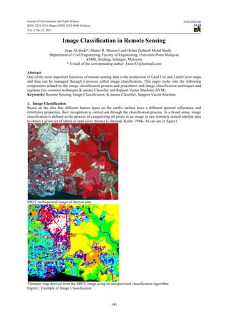
  • 1. Journal of Environment and Earth Science ISSN 2224-3216 (Paper) ISSN 2225-0948 (Online) Vol. 3, No.10, 2013 www.iiste.org Image Classification in Remote Sensing Jwan Al-doski*, Shattri B. Mansor1 and Helmi Zulhaidi Mohd Shafri Department of Civil Engineering, Faculty of Engineering, Universiti Putra Malaysia 43400, Serdang, Selangor, Malaysia * E-mail of the corresponding author: Jwan-83@hotmail.com Abstract One of the most important functions of remote sensing data is the production of Land Use and Land Cover maps and thus can be managed through a process called image classification. This paper looks into the following components related to the image classification process and procedures and image classification techniques and explains two common techniques K-means Classifier and Support Vector Machine (SVM). Keywords: Remote Sensing, Image Classification, K-means Classifier, Support Vector Machine 1. Image Classification Based on the idea that different feature types on the earth's surface have a different spectral reflectance and remittance properties, their recognition is carried out through the classification process. In a broad sense, image classification is defined as the process of categorizing all pixels in an image or raw remotely sensed satellite data to obtain a given set of labels or land cover themes (Lillesand, Keifer 1994). As can see in figure1. SPOT multispectral image of the test area Thematic map derived from the SPOT image using an unsupervised classification algorithm. Figure1. Example of Image Classification 141
  • 2. Journal of Environment and Earth Science ISSN 2224-3216 (Paper) ISSN 2225-0948 (Online) Vol. 3, No.10, 2013 www.iiste.org 2. Image Classification Procedures General image classification procedures include: • Design image classification scheme: they are usually information classes such as urban, agriculture, forest areas, etc. Conduct field surveys and collect ground information and other ancillary data of the study area. • Preprocessing of the image, including radiometric, atmospheric, geometric and topographic corrections, image enhancement, and initial image clustering. • Select representative areas of the image and analyze the initial clustering results or generate training signatures. • Image classification algorithms running. • Post-processing: complete geometric correction & filtering and classification decorating. • Accuracy assessment: compare classification results with field studies. (Gong and Howarth 1990): 3. Image Classification Techniques There are various classification approaches that have been developed and widely used to produce land cover maps (Aplin, Atkinson 2004). They range in logic, from supervised to unsupervised; parametric to nonparametric to non-metric, or hard and soft (fuzzy) classification, or per-pixel, sub-pixel, and prefield (Keuchel et al. 2003a, Jensen 2005) as can be seen from the brief descriptions of these categories in Table 1. However, there are two broad types of classification procedure and each finds application in the processing of remote sensing images: one is referred to as supervised classification and the other one is unsupervised classification. These can be used as alternative approaches, but are often combined into hybrid methodologies using more than one method (Richards, Jia 2006). Table1.Summary of Remote Sensing Classification Techniques Methods Examples Characteristics Maximum Likelihood classification Assumptions: Data area normally distributed Prior Parametric and Unsupervised classification Knowledge of class density functions etc. Nearest-neighbor classification, No prior assumptions are made Non-Parametric Fuzzy classification , Neural networks and support Vector machines etc. Rule-based Decision tree Can operate on both real-valued data and nominal Non-metric classification scaled data statistical analysis Maximum Likelihood, Minimum Analyst Identifies training sites to represent in Supervised Distance , and Parallelepiped classes and each pixel is classified based on classification etc. statistical analysis Unsupervised ISODATA and K-means etc. Hard (parametric) Supervised and Unsupervised classifications Fuzzy Set Classification logic Soft (nonParametric) Pre-Pixel Object-oriented Prior ground information not known. Pixels with similar spectral characteristics are grouped according to specific statistical criteria Classification using discrete categories Considers the heterogeneous nature of real world Each pixel is assigned a proportion of the in land cover type found within the pixel Classification of the image pixel by pixel Image regenerated into homogenous objects Classification preformed on each object and pixel Includes expert systems and artificial intelligence Hybrid Approaches (Source Jensen, 2005: pp337-338) Unsupervised image classification is a method in which the image interpreting software separates a large number of unknown pixels in an image based on their reflectance values into classes or clusters with no direction from the analyst (Tou, Gonzalez 1974). There are two most frequent clustering methods used for unsupervised classification: K-means and Iterative Self-Organizing Data Analysis Technique (ISODATA). These two methods rely purely on spectrally pixel-based statistics and incorporate no prior knowledge of the characteristics of the themes being studied. On the other hand, supervised classification is a method in which the analyst defines small 142
  • 3. Journal of Environment and Earth Science ISSN 2224-3216 (Paper) ISSN 2225-0948 (Online) 0948 Vol. 3, No.10, 2013 www.iiste.org areas called training sites on the image, which contain the predictor variables measured in each sampling unit, and assigns prior classes to the sampling uni (Černá, Chytrý 2005). The delineation of training areas units . representative of a cover type is most effective when an image analyst has knowledge of the geography of a region and experience with the spectral properties of t cover classes (Skidmore 1989). the The following diagrams show the major steps in the two common types of image classification classification: Unsupervised Supervised The supervised technique has some advantage over the unsupervised one. In the supervised approach, useful unsupervised information categories are distinct first, and then their spectral separability is examined while in the unsupervised approach, the computer determines spectrally separable class, and then defines their inform information value (Lillesand, Keifer 1994). Besides, unsupervised classification is easy to apply, does not require analyst . analystspecified training data and is widely available in image processing and statistical software p packages; moreover it automatically converts raw image data into useful information so long as there is higher classification accuracy (Langley, Cheshire & Humes 2001), but one disadvantage of this classification is that the classification process has to be repeated if new data (samples) are added. Nevertheless; there are many limitations of both major classification methods (supervised and unsupervised) that were realized by Castellana, d’Addabbo & Pasquariello (2 (2007) during independent utility and this led them to ) develop a new classification approach called “hybrid classification method”. On the other hand, when using new generation images, characterized by a higher spatial and spectral resolution, it is still d difficult to obtain satisfactory results by using supervised and unsupervised methods alone (Lewiński, Zaremski 2004) therefore, scientists have made great effor to develop advanced classification procedures which has resulted in the Automated Classification Approach used by (Ratanopad, Kainz 2006), Rx Classification Method (Zhang et al. , 2007), Object-based Classification (Gamanya, De Maeyer & De Dapper 2009), SVM (Walter 2004), based , Standardized Object Oriented Automatic Classification (SOOAC) method based on fuzzy Logic, Knowledge Knowledgebased Stratified Classification, Artificial Neural Networks(ANN) (Chen et al. 2002), Decision Tree Classification , Method (DT) (Su et al. 2011), Bayesian and Hybrid Classifier (Pradhan, Ghose & Jeyaram 2010) , 2010). 3.1 K-means Classifier In this approach, classes are determined statistically by assigning pixels to the nearest cluster mean based on all available bands. In K-Means, a sequence of iteration starts with a initial set C Means, an (Tou, Gonzalez 1974) At each 1974). iteration t all c € C pixels are assigned to one of the clusters S as defined by the nearest neighbor principle. A new center C For a cluster is computed as follows: 1 However, the result of the K-Means clustering or the output of this technique could be influenced by the number Means of cluster centers specified, the choice of the initial cluster center, the sampling nature, the geometrical properties cluster of the data, and clustering parameters (Vanderzee, Ehrlich 1995). It is relatively straightforward and has . considerable intuitive appeal. 3.2 Support Vector Machine (SVM) Recently, Support Vector Machine (SVM) classification algorithm has been used to classify imagery obtained from remote-sensing satellites (Keuchel et al. 2003b). SVM, the work of Vapnik and colleagues in the 1990’s, 2003b). was previously utilized in a remote sensing context by Gualtieri and Cromp in 1998 and Pal and Mather, 2005. This classification algorithm had been shown to be effective for face recognition in photos, handwriting and object recognition before it was adopted for use in remote sensing (Pal, Mather 2005, Hermes et al. 1999) and fore has proved popular for hyperspectral remote remote-sensing data (Camps-Valls et al. 2004, Melgani, Bruzzone 2004, Valls Fauvel, Chanussot & Benediktsson 2006). Besides these successful applications of hyperspectral data, SVM is 2006). being used for various data types such as L Landsat multispectral data. It is a non-parametric classifier that parametric differentiates and divides the classes by determining the boundaries in feature space and maximizes the margin between the classes (Keuchel et al. 200 . The surface is often called the optimal hyper plane, and the data 2003b). points closest to the hyper plane are called support vectors. Classes are not separated by statistical learning theory means as in the maximum likelihood classifier, but by geometric criteria (Fauvel, Chanussot & criteria 143
  • 4. Journal of Environment and Earth Science ISSN 2224-3216 (Paper) ISSN 2225-0948 (Online) Vol. 3, No.10, 2013 www.iiste.org Benediktsson 2006). The support vectors consider the critical elements of the training set. Implementation of SVM by the ENVI 4.8 software uses the pairwise classification strategy for multiclass classification. SVM classification output is the decision values of each pixel for each class, which are used for probability estimates. The ENVI4.8 software performs classification by selecting the highest probability. An optional threshold allows reporting pixels with all probability values less than the threshold as unclassified. SVM includes a penalty parameter that allows a certain degree of misclassification, which is particularly important for non-separable training sets. The penalty parameter controls the tradeoff between allowing training errors and forcing rigid margins. For example, assume that two classes are spectrally separable in feature space. If the two classes are separated by a line drawn in the feature space, to separate these two classes, the space between the two classes identifying a central hyperplane should be maximized (Pal, Mather 2005). To identify the hyperplane, the central distance between the closest points of each of the two classes is measured. These points are referred to as support vectors (Pal, Mather 2005). An SVM, simply demonstrated, is a binary example in a two dimensional feature space, as shown in Figure 2. It is assumed that N training samples exist in the feature space with corresponding labels yi= +1 or yj= -1 respectively (Fauvel, Chanussot & Benediktsson 2006). To define the optimal hyperplane, w represents the vector normal to the hyperplane and b represents the bias so the hyperplane and is defined as: ∗ + 0 Where x= a point lying on the hyperplane w = is normal to the hyperplane b = bias |!| = the perpendicular distance from the hyperplane to the origin with the Euclidean norm of w "#" (Foody, Mathur 2004) For any training pixel x, the distance from the hyperplane can be calculated by: f x w∗x+b For a training pixel x to be classified in either class, it must satisfy one of the two following conditions: Yi (w. X i+ b) ≥+1 or Yi (w .X i+b) -1 Linearly separable data are ideal but rarely occur in a real world data set. For non-linearly separable, there is a need to introduce lack variables ξ so that misclassified pixels transferred back to their original class in feature space (Fauvel, Chanussot & Benediktsson 2006). Therefore the conditions are: Yi (w. Xi +b) >1 – ≥0 or Yi (w. Xi +b) <-1Final optimization of the margin is defined as: " ", ()* + + 2 ≥0 . / 0 Where; C represents the penalty parameter (Fauvel et al., 2006). (Adapted from Fauvel, Chanussot & Benediktsson 2006) Figure2.Example of a Non-Linearly Separable Case by SVM This penalty parameter entered by the analyst in the ENVI 4.8 software, allows for a certain level of misclassifications. Larger assigned C value assigned means higher penalty for misclassified pixels (Pal, Mather 2005). Initially, SVM was a binary classification but a multiclass classification problem can be analyzed in order to examine a combination of several binary classifications, or basically, each pair of classes is measured 144
  • 5. Journal of Environment and Earth Science ISSN 2224-3216 (Paper) ISSN 2225-0948 (Online) Vol. 3, No.10, 2013 www.iiste.org separately (Pal & Mather, 2005; ITT Visual Information Solutions, 2008b) and others indicated that this strategy gave the optimum results in the case of a multi-class scenario (Pal, Mather 2005, Melgani, Bruzzone 2004). In fact, Mprovidesand Bruzzone (2004) state that SVMs provides higher accuracy than traditional methods such as the MLC, a theory that was tested by Melgani and Bruzzone (2004) for land cover classification mapping. Likewise, in remote-sensing, it is not common to create linearly separable sets of training classes, but by using kernels, nonlinear SVMs can be developed (Fauvel, Chanussot & Benediktsson 2006). Kernel methods can generalize remote sensing data through sorting and projection of data into a higher dimension (Fauvel, Chanussot & Benediktsson 2006). There are several kernels to choose from. The ENVI 4.8 software provides four different types: linear, polynomial, sigmoid, and radial basis function (RBF). This study chose RBF as it provides optimum results and has been proven to be the most popular from the literature (Pal, Mather 2005, Hermes et al. 1999, Melgani, Bruzzone 2004, Fauvel, Chanussot & Benediktsson 2006). The RBF kernel is defined as follows: , , 2 3 4−67 − 7 8 In which the gamma γ parameter is entered by the analyst and controls the width of the kernel (Foody, Mathur 2004). In order to use the RBF kernel in the ENVI 4.8 software, the gamma γ and C parameters need to be wisely selected to avoid the SVM over fitting the training data, a common result of using high values for the two parameters (Foody, Mathur 2004). There is little information in the literature on ways to identify these parameters; as such, there is a necessity to resort to trial and error to select the optimal values for γ and C (Pal, Mather 2005). 4. Over View of Image classification Until today, there is still need to produce regional land use land cover maps for the variety of purposes of government, public, private, and national security applications besides to support regional landscape planning and resource management (Aplin, Atkinson 2004, Jensen 2005). Many new classifications have been introduced and have become more popular compared to supervised classification and unsupervised classification (traditional classification algorithms) for land use and land cover mapping , change detection and improve the accuracy of maps and classified images. Dewan, Yamaguchi (2009) used the (ISODATA) clustering algorithm with the maximum likelihood method to produce classification maps as well as the same classification algorithms used by Binh et al. ( 2005) to create land cover maps and detect land cover changes in Vietnam. Müllerová in (2005) utilized (ISODATA) clustering algorithm, the Parallelepiped and Maximum Likelihood classification to land cover mapping. For a particular study, it is often difficult to identify the best classifier due to the lack of a guideline for selection and the availability of suitable classification algorithms to hand. With the availability of various classification methods, the popular approach is a comparative analysis to try and decide what is best for a specific dataset. Moreover, the combination of different classification approaches has shown to be helpful for the improvement of classification accuracy. Many of classification algorithms are compared such as the study conducted by Guo et al. (2008), in which four broad classification methods were employed, which are Maximum Likelihood Classification (MLC), Self-Organized Neural Network (SONN), Support Vector Machine (SVM), and Decision Tree Classification (DTC). In conclusion, DTC determined as the best and MLC as one of the classical methods as it is more stable than the other three methods. While in another study conducted by (Pal, Mather 2005)Pal and Mather (2005), there was a comparison of Support Vector Machines (SVM), Maximum Likelihood, and Neural Network (ANN) classifiers to identify land cover types using Landsat 7 ETM+ and hyper spectral data. Both Neural Network (ANN) and SVM classifiers are dependent on user-defined parameters to achieve proper functionality. Results for the classifications showed SVM produced the most accurate results for both types of data. In a another study presented by Foody and Mathur (2004), SVM was tested against other classifiers, Decision Trees and Neural Network data in an agricultural area in England to produce land use / land cover maps and determine the highest overall accuracy. The SVM classification resulted in 93.8% accuracy despite the ability of the SVM to function with minimum training data, training set size and overall accuracy are positively related (Foody, Mathur 2004). The classification process and results are influenced by a variety of factors, including availability of remotely sensed data, landscape complexity, image band selection, the classification algorithm used, analyst’s knowledge about the study area, and analyst’s experience with the classifiers used Due to lack of reference and raw data in order to produce high accuracy classified images and maps, some researchers tried to combine most of the classification methods together as Hybrid classification. Hybrid classification takes advantage of both the supervised classification and unsupervised classification. In this method, multi-spectral images, firstly, an unsupervised one is preformed, then the result is interpreted using ground truth knowledge and, finally the original images are reclassified using a supervised classification with the aid of the statistics of the unsupervised classification as training knowledge. For example, Zaki, Abotalib Zaki 145
  • 6. Journal of Environment and Earth Science ISSN 2224-3216 (Paper) ISSN 2225-0948 (Online) Vol. 3, No.10, 2013 www.iiste.org (2011) have obtained high results by using hybrid classification in a combination of unsupervised classifications (ISODATA) and Maximum likelihood as supervised to produce land cover maps by using multi-temporal Landsat images (TM) in Northeast Cairo, Egypt. Then, the post classification change detection technique and field investigation were applied and this method has proved beneficial for understanding human activity impacts on the urban environment. In a similar study, Alphan, Doygun and Unlukaplan (2009) used the same hybrid combination of multi-temporal Landsat and ASTER imagery to assess land cover (LC) changes in Turkey. Both studies concluded that this combination was useful to increase classification accuracy. 5. Conclusion One of the most important uses of remote sensing is the production of Land Use / Land Cover maps and thus can be done through a process called “Image Classification”. Image Classification had made great progress over the past decades in the following four areas: (1) producing land cover map at regional and global scale; (2) development and use of advanced classification algorithms, such as subpixel, pre-field, and knowledge-based classification algorithms; (3) use of multiple remote-sensing features, including spectral, spatial, multitemporal, and Multisensor information; and (4) incorporation of ancillary data into classification procedures, including such data as topography, soil, road, and census data. Accuracy assessment is an integral part in an image classification procedure.The success of an image classification in remote sensing depends on many factors, the availability of high-quality remotely sensed imagery and ancillary data, the design of a proper classification procedure, and the analyst’s skills and experiences. Reference Alphan, H., Doygun, H. & Unlukaplan, Y.I. 2009, "Post-classification comparison of land cover using multitemporal Landsat and ASTER imagery: the case of Kahramanmaraş, Turkey", Environmental monitoring and assessment, vol. 151, no. 1, pp. 327-336. Aplin, P. & Atkinson, P.M. 2004, "Predicting missing field boundaries to increase per-field classification accuracy", Photogrammetric Engineering and Remote Sensing, vol. 70, no. 1, pp. 141-149. Binh, T.N.K.D., Vromant, N., Hung, N.T., Hens, L. & Boon, E. 2005, "Land cover changes between 1968 and 2003 in Cai Nuoc, Ca Mau peninsula, Vietnam", Environment, Development and Sustainability, vol. 7, no. 4, pp. 519-536. Camps-Valls, G., Gómez-Chova, L., Calpe-Maravilla, J., Martín-Guerrero, J.D., Soria-Olivas, E., AlonsoChordá, L. & Moreno, J. 2004, "Robust support vector method for hyperspectral data classification and knowledge discovery", Geoscience and Remote Sensing, IEEE Transactions on, vol. 42, no. 7, pp. 15301542. Castellana, L., d’Addabbo, A. & Pasquariello, G. 2007, "A composed supervised/unsupervised approach to improve change detection from remote sensing", Pattern Recognition Letters, vol. 28, no. 4, pp. 405-413. Černá, L. & Chytrý, M. 2005, "Supervised classification of plant communities with artificial neural networks", Journal of Vegetation Science, vol. 16, no. 4, pp. 407-414. Chen, P., Lu, X., Liew, S. & Kwoh, L. 2002, "Quantification of land cover change and its impact on hydrogeomorphic processes in the upper yangtze using multi-temporal Landsat imagery: An example of the Minjiang area", Geoscience and Remote Sensing Symposium, 2002. IGARSS'02. 2002 IEEE InternationalIEEE, , pp. 1216. Dewan, A.M. & Yamaguchi, Y. 2009, "Using remote sensing and GIS to detect and monitor land use and land cover change in Dhaka Metropolitan of Bangladesh during 1960-2005", Environmental monitoring and assessment, vol. 150, no. 1-4, pp. 237-249. Fauvel, M., Chanussot, J. & Benediktsson, J.A. 2006, "Evaluation of kernels for multiclass classification of hyperspectral remote sensing data", Acoustics, Speech and Signal Processing, 2006. ICASSP 2006 Proceedings. 2006 IEEE International Conference onIEEE, , pp. II. Foody, G.M. & Mathur, A. 2004, "A relative evaluation of multiclass image classification by support vector machines", Geoscience and Remote Sensing, IEEE Transactions on, vol. 42, no. 6, pp. 1335-1343. Gamanya, R., De Maeyer, P. & De Dapper, M. 2009, "Object-oriented change detection for the city of Harare, Zimbabwe", Expert Systems with Applications, vol. 36, no. 1, pp. 571-588. Gong P. and P.J. Howarth, 1990. An assessment of some factors influencing multispectral land-cover classification, Photogrammetric Engineering and Remote Sensing, 56(5):597-603. Gualtieri, J.A. & Cromp, R.F. 1999, "Support vector machines for hyperspectral remote sensing classification", The 27th AIPR Workshop: Advances in Computer-Assisted RecognitionInternational Society for Optics and Photonics, , pp. 221. Guo, J., Zhang, J., Zhang, Y. & Cao, Y. 2008, "Study on the comparison of the land cover classification for multitemporal MODIS images", Earth Observation and Remote Sensing Applications, 2008. EORSA 146
  • 7. Journal of Environment and Earth Science ISSN 2224-3216 (Paper) ISSN 2225-0948 (Online) Vol. 3, No.10, 2013 www.iiste.org 2008. International Workshop onIEEE, , pp. 1. Hermes, L., Frieauff, D., Puzicha, J. & Buhmann, J.M. 1999, "Support vector machines for land usage classification in Landsat TM imagery", Geoscience and Remote Sensing Symposium, 1999. IGARSS'99 Proceedings. IEEE 1999 InternationalIEEE, , pp. 348. Jensen, J. 2005, "Introductory Digital Image Processing, 3rd", . Keuchel, J., Naumann, S., Heiler, M. & Siegmund, A. 2003a, "Automatic land cover analysis for Tenerife by supervised classification using remotely sensed data", Remote Sensing of Environment, vol. 86, no. 4, pp. 530-541. Keuchel, J., Naumann, S., Heiler, M. & Siegmund, A. 2003b, "Automatic land cover analysis for Tenerife by supervised classification using remotely sensed data", Remote Sensing of Environment, vol. 86, no. 4, pp. 530-541. Langley, S.K., Cheshire, H.M. & Humes, K.S. 2001, "A comparison of single date and multitemporal satellite image classifications in a semi-arid grassland", Journal of Arid Environments, vol. 49, no. 2, pp. 401-411. Lewiński, S. & Zaremski, K. 2004, "Examples of object-oriented classification performed on high-resolution satellite images", Warszawa, vol. 11, pp. 349-358. Lillesand, T.M. & Keifer, R.W. 1994, Remote Sensing and Image Interpretation, . Melgani, F. & Bruzzone, L. 2004, "Classification of hyperspectral remote sensing images with support vector machines", Geoscience and Remote Sensing, IEEE Transactions on, vol. 42, no. 8, pp. 1778-1790. Müllerová, J. 2005, "Use of digital aerial photography for sub-alpine vegetation mapping: A case study from the Krkonoše Mts., Czech Republic", Plant Ecology, vol. 175, no. 2, pp. 259-272. Pal, M. & Mather, P. 2005, "Support vector machines for classification in remote sensing", International Journal of Remote Sensing, vol. 26, no. 5, pp. 1007-1011. Pradhan, R., Ghose, M. & Jeyaram, A. 2010, "Land Cover Classification of Remotely Sensed Satellite Data using Bayesian and Hybrid classifier", International Journal of Computer Applications IJCA, vol. 7, no. 11, pp. 1-4. Ratanopad, S. & Kainz, W. 2006, "Land cover classification and monitoring in northeast thailand using landsat5 TM data", ISPRS Technical Commission II Symposium, Vienna. Richards, J.A. & Jia, X. 2006, Remote sensing digital image analysis: an introduction, Springer Verlag. Skidmore, A. 1989, "Unsupervised training area selection in forests using a nonparametric distance measure and spatial information", Remote Sensing, vol. 10, no. 1, pp. 133-146. Su, X., Wu, W., Li, H. & Han, Y. 2011, "Land-Use and Land-Cover Change Detection Based on ObjectOriented Theory", Image and Data Fusion (ISIDF), 2011 International Symposium on, pp. 1. Tou, J.T. & Gonzalez, R.C. 1974, "Pattern recognition principles", Image Rochester NY, vol. 7. Vanderzee, D. & Ehrlich, D. 1995, "Sensitivity of ISODATA to changes in sampling procedures and processing parameters when applied to AVHRR time-series NDV1 data", Remote Sensing, vol. 16, no. 4, pp. 673686. Walter, V. 2004, "Object-based classification of remote sensing data for change detection", ISPRS Journal of Photogrammetry and Remote Sensing, vol. 58, no. 3, pp. 225-238. Zaki, R. & Abotalib Zaki, S.A. 2011, "Land Use and Land Cover Changes in Arid Region: The Case New Urbanized Zone, Northeast Cairo, Egypt", Journal of Geographic Information System, vol. 3, no. 3, pp. 173-194. Zhang, Z.M., Verbeke, L., De Clercq, E., Ou, X.K. & De Wulf, R. 2007, "Vegetation change detection using artificial neural networks with ancillary data in Xishuangbanna, Yunnan Province, China", Chinese Science Bulletin, vol. 52, pp. 232-243. 147
  • 8. This academic article was published by The International Institute for Science, Technology and Education (IISTE). The IISTE is a pioneer in the Open Access Publishing service based in the U.S. and Europe. The aim of the institute is Accelerating Global Knowledge Sharing. More information about the publisher can be found in the IISTE’s homepage: http://www.iiste.org CALL FOR JOURNAL PAPERS The IISTE is currently hosting more than 30 peer-reviewed academic journals and collaborating with academic institutions around the world. There’s no deadline for submission. Prospective authors of IISTE journals can find the submission instruction on the following page: http://www.iiste.org/journals/ The IISTE editorial team promises to the review and publish all the qualified submissions in a fast manner. All the journals articles are available online to the readers all over the world without financial, legal, or technical barriers other than those inseparable from gaining access to the internet itself. Printed version of the journals is also available upon request of readers and authors. MORE RESOURCES Book publication information: http://www.iiste.org/book/ Recent conferences: http://www.iiste.org/conference/ IISTE Knowledge Sharing Partners EBSCO, Index Copernicus, Ulrich's Periodicals Directory, JournalTOCS, PKP Open Archives Harvester, Bielefeld Academic Search Engine, Elektronische Zeitschriftenbibliothek EZB, Open J-Gate, OCLC WorldCat, Universe Digtial Library , NewJour, Google Scholar