GPS Geodetik Horizon Kronos 300 RTK L1L2L5

PT. Minds Indo Survey Komp/ Ruko Mega Kalimalang Kav.8 Jl. KH Noer Ali No.11 Pekayon, Bekasi Telp : 021-95099644, Fax : 021-88860790 Mobile : 082119953499/ 087886144398, PIN : 237FC845 Email : budi1080@yahoo.com/ budi1080@gmail.com PT. Minds Indo Survey hadir Sebagai Distributor Alat Survey tanah atau bangunan yang mampu memberikan solusi terlengkap untuk memenuhi kebutuhan Pengadaan Alat-alat ukur survey dan Pemetaan beserta accessories pendukungnya, Sekarang ini, kita telah masuk di era globalisasi dalam segala hal termasuk era globalisasi technologi yang mempunyai percepepatan perkembangan dari satu technology ke generasi technology yang lebih muthakir, semua orang bisa saling berhubungan dengan berbagai latar belakang keperluan yang berbeda-beda tentunya harus di dukung oleh Infra strukture Networking menjadi hal baku yang di perlukan Oleh Semua Orang baik itu untuk keperluan Perusahaan ataupun Sebuah Organisasi. Adapun lingkup pekerjaan kami meliputi: Penjualan, Service/Perbaikan dan Rental dengan menghadirkan merk sebagai berikut : 1. Nikon 2. Spectra 3. Minds 4. Garmin 5. Horizon A.Penjualan ( Sale ): NIKON : I.Nikon Automatic Level : 1. Automatic Level Nikon AC2S 2. Automatic Level Nikon AE7 3. Automatic Level Nikon AS2C II.Digital Theodolite Nikon : 1.Theodolite Nikon NE-100 2. Theodolite Nikon NE-102 III. Total Station Nikon: 1.Total Station Nikon DTM 322 (1 Muka) 2.Total Station Nikon DTM 322 + 3.Total Station Nikon NPL 322 4.Total Station Nikon NPL 322 5.Total Station Nikon Nivo 2 M 6. Total Station Nikon Nivo 3 M Spectra : I. Automatic Level Spectra 1.Automatice Level Spectra AL-20 M 2.Automatice Level Spectra AL-24 M 3.Automatice Level Spectra AL-28 M 4.Automatice Lavel Spectra AL-32 A 5. Focus DL-15 Digital Level II. Theodolite Spectra 1.Thedolite Spectra DET-02 III. Total Station Spectra 1.Total Station Spectra Focus 6 (5”) 2.Total Station Spectra Focus 6 (2”) 3.Total Station Spectra Focus 8 (5”) 4.Total Station Spectra Focus 8 (2”) IV. GPS Hand Held ( Mapping ) 1.Mobile Mapper Ashtech MM 20 2. Mobile Mapper Ashtech MM 120 V. GPS Geodetice 1.Promark 120 L1 GPS 2.Promark 120 L1 GPS Glonass 3. Promark 220 RTK L1 L2 4.GPS Geodetic Spectra SP80 GNSS Receiver 5. Promark 700 6. Promark 800 8. Kronos 300 MINDS I. Minds Automatic Level : 1.Minds Automatice Level AT-28 2.Minds Automatice Level AT-32 II.Theodolite Minds 1.Theodolite Minds CDT-02 2.Theodolite Minds MDT-02 3. Theodolite Minds MDT-2 Laser Pointer Garmin I.GPS Garmin 1.GPS Garmin 78 S 2.GPS Garmin 62 S 3.GPS Garmin Etrex 10 4.GPS Garmin Etrex 30 Catatan : Price List akan dikirim sesuai permintaan

Recommended
More Related Content
Viewers also liked
Viewers also liked (15)
More from Budi anto
More from Budi anto (20)
Recently uploaded
Recently uploaded (20)
GPS Geodetik Horizon Kronos 300 RTK L1L2L5
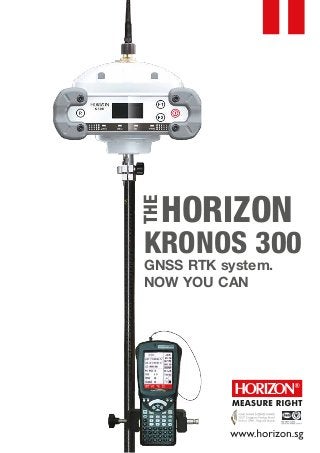
- 1. HORIZON THE KRONOS 300 GNSS RTK system. NOW YOU CAN
- 2. The Kronos 300 is a GNSS receiver that allows you to do more, a HORIZON GNSS product which continues with the tradition of performance excellence shown by the Kronos 200 GNSS system. It now features a more robust and rugged housing, within which resides a faster and more powerful BD970 board built on the proven Maxwell 6 technology. Like the Kronos 200, the Kronos 300 also features an in-built GSM/GPRS module, as well as an in-built UHF transmitter module for a complete communication interface. The UHF module has been upgraded to a power-switchable type, which would allow a transmission range of beyond 8km independently. The completely new Kronos 300 housing now features an illuminated display LED screen, which would let you check on various operation and satellite statuses during operation. It has also been designed to be very rugged and robust, providing safety contingencies for accidental drops from a height of 2metres onto concrete during operation. The waterproofing capability of the Kronos 300 is rated at IP67. Working in the rain (if necessary) would not present any problems. The Kronos 300 has also been fitted with two in-built batteries, with a total capacity of 8800mAH. This would allow you to operate the receiver up to 20hrs when fully charged. You can now do more with the Kronos 300. Yes you can. KRONOS 300 GNSS SYSTEM FEATURES AT A GLANCE: Featuring the Upgraded Trimble Maxwell 6 Technology BD970 Motherboard. An amply proven technology, now made better. Inbuilt GPRS/GSM Module, for a complete and versatile communication interface. UHF Transmitting Antenna- All Direction Antenna (100W, gain 7.5dBI) for extended transmission range. Inbuilt Twin Batteries With a total capacity of 8800mAh, the receiver is capable for operations of up to 20 hours Inbuilt Radio Transmitter The 0.5-2W (switchable) UHF radio module allows coverage of beyond 6km under optimal conditions. Advanced OLED With 1.53’OLED, mode settings and operation status can be easily accessed during operation Outstanding Waterproof Capability IP67 Standard and allows for water immersion of up to 1metre. New and Extremely Rugged Housing Designed and built to withstand a 2m drop onto concrete or other hard surfaces. –
- 3. INTERNAL RADIO PACKET DATA SERVICE OF GPRS KRONOS 300 GNSS SYSTEM TECHNICAL SPECIFICATIONS Internal Memory Number of Channels Satellite signals tracked QZSS: GPS: GLONASS: SBAS: GALILEO: COMPASS: 4G (15 static days with frequency of 1 Hz) 220 Simultaneous L1 C/A, L2E, L2C, L5 Simultaneous L1 C/A, L1 P, L2 C/A (GLONASS M Only), L2 P Simultaneous L1 C/A, L5 Simultaneous L1 BOC, E5A, E5B, E5AltBOC1 B1,B2 L1 C/A, L1 SAIF,L2C, L5 PERFORMANCE SPECIFICATION PROCESSORS CONNECTION DEVICES Initialization time: Signal recapture: RTK signal initialization: Velocity Accuracy Acceleration Maximum Operating Limits Velocity Altitude 45 sec 1 sec 20 sec Horizontal-0.007 m/s Vertical 0.020m/s 11 g 515m/s 18,000 m Proven low elevation tracking technology. Up to 50 Hz raw measurement & position outputs. Very low noise GNSS carrier phase measurements with <1 mm precision in a 1 Hz bandwidth Trimble BD970 main board, GSM/GPRS module: SIEMENS MC75i Maximum rate of transmission 85.6 kbit/s. GSM/GPRS bands supported Single band operation at 800 MHz, Dual band operation at 900 MHz and 1800 MHz, Tri-band operation at 800 MHz, 900 MHz, 1800 MHz. CLASS 10 Embedded TCP/IP protocol suite that supports multiple links and provides ACK answer and large-capacity cache. Connectors I/O: 9-pins serial port (baud rate up to 115.200kbps) Multicable with USB interfaces for connecting with PC. 2.4GHz Bluetooth device class II Maximum range of 50m. Integrated Radio Receiver/Transmitter With External Radio(optional):25W, UHF Range(varies with terrain/temperature):8-10km typical, 15-20km optimal 0.5-2W selectable 410-430MHZ,430-450MHZ,450-470MHZ Optional ( default 0.5W,450-470MHz) UHF Range(varies with terrain/temperature, and power selected): >4km – 8km
- 4. PHYSICAL SPECIFICATIONS: SERIAL PROTOCOLS GSM/GPRS MODEM RECEIVER ACCURACY Humidity Weight External cellphone support for GPRS/GSM (2G default,3G Optional), Module for network RTK (CORS) Operations, VRS ( optional) Reference outputs Navigation outputs: Network RTK (via CORS) range varies w/ temperature/GPRS Date rate): 20-50km CMR+, CMRx, RTCM 2.1, RTCM 2.3, RTCM 3.0, RTCM 3.1. ASCII (NMEA-0183 GSV), AVR, RMC, HDT, VGK, VHD, ROT, GGK, GSA, ZDA, VTG, GST, PJT, PJK, BPQ, GLL, GRS, GBS, GSOF. POWER SUPPLY (12-15V DC EXTERNAL POWER INPUT) Operational temperature Static horizontal accuracy Static vertical accuracy Fixed RTK horizontal accuracy Fixed RTK vertical accuracy Code Differential GNSS Positioning ( Horizontal) Code Differential GNSS Positioning ( Vertical) SBAS differential positioning accuracy 3mm ± 1ppm (RMS). 5mm ± 1ppm (RMS). 8mm ± 1ppm (RMS). 15mm ± 1ppm (RMS). 25cm ± 1ppm (RMS). 50cm ± 1ppm (RMS). <5m 3DRMS Stand Alone RTK positioning accuracy 1.5m (CEP). Rechargeable, 7.2V, 8800mAh Lithium-Ion Size Working time Typically 18-20 hours for built-in battery (varies with operation mode and environmental factors) Storage temperature Waterproof/Dustproof Shock & Vibration resistance Up to 100% Weight 1.85kg (including inbuilt battery and radio module) - 45°C to 60°C (-49°F to 140°F) Dimensions (LxWxH) 165mm x 168mm x 122mm (6.5in x 6.6in x 4.8in) - 55°C to 85°C (-67°F to 185°F) IP67 2m drop against hard surface