Marifil Mines K-2 Potash Project Fact Sheet
•
0 recomendaciones•257 vistas

October 2011

Recomendados
Más contenido relacionado
Similar a Marifil Mines K-2 Potash Project Fact Sheet
Similar a Marifil Mines K-2 Potash Project Fact Sheet (20)
Más de Viral Network Inc
Más de Viral Network Inc (20)
Último
Último (20)
Marifil Mines K-2 Potash Project Fact Sheet
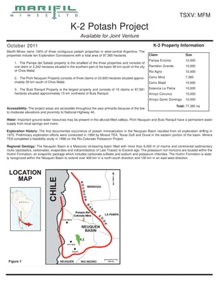
- 1. TSXV: MFM K-2 Potash Project Available for Joint Venture October 2011 K-2 Property Information Marifil Mines owns 100% of three contiguous potash properties in west-central Argentina. The properties include ten Exploration Concessions with a total area of 97,385 hectares. Claim Size Pampa Encima 10,000 1. The Pampa del Salado property is the smallest of the three properties and consists of one claim or 2,242 hectares situated in the southern part of the basin 90 km south of the city Ramblon Grande 10,000 of Chos Malal. Rio Agrio 10,000 2. The Pichi Neuquen Property consists of three claims or 23,800 hectares situated approx- Cerro Mina 7,385 imately 50 km south of Chos Malal. Cerro Malal 10,000 3. The Buta Ranquil Property is the largest property and consists of 10 claims or 87,581 Estancia La Patria 10,000 hectares situated approximately 15 km northwest of Buta Ranquil. Arroyo Covunco 10,000 Arroyo Santo Domingo 10,000 Total: 77,385 ha Accessibility: The project areas are accessible throughout the year primarily because of the low to moderate elevations and proximity to National Highway 40. Water: Important ground water resources may be present in the alluvial-filled valleys. Pichi Neuquen and Buta Ranquil have a permanent water supply from local springs and rivers. Exploration History: The first documented occurrence of potash mineralization in the Neuquen Basin resulted from oil exploration drilling in 1975. Preliminary exploration efforts were conducted in 1984 by Minera TEA, Texas Gulf and Duval in the eastern portion of the basin. Minera TEA completed a feasibility study in 1998 on the Rio Colorado Potassium Project. Regional Geology: The Neuquén Basin is a Mesozoic oil-bearing basin filled with more than 6,000 m of marine and continental sedimentary rocks (epiclastics, carbonates, evaporates and volcaniclastics) of Late Triassic to Eocene age. The potassium rich horizons are located within the Huitrin Formation, an evaporitic package which includes carbonate sulfates and sodium and potassium chlorides. The Huitrin Formation is wide- ly recognized within the Neuquen Basin to extend over 400 km in a north-south direction and 100 km in an east-west direction.
- 2. K-2 PROJECT SUMMARY CONTINUED Mineralization: The nearest known potash deposit, El Porton contains two high grade silvinite horizons; the upper horizon is 5 m thick and the lower horizon is 10 m thick. These potash horizons continue to the east for 40 km where the Potasio Rio Colorado Mine is located. To the west these potash horizons terminate against a tectonically uplifted block. Further west, beyond the uplifted block, the stratigra- phy continues un-interrupted as in the eastern part; there- fore, it is highly probable to find potash mineralization of sim- ilar size and grade as found in the El Porton deposit. Exploration: Exploration work performed to date on the Marifil properties consists of a detailed study of surface geol- ogy, stratigraphy and structure. Seismic geophysical studies have been conducted over the project areas by petroleum companies and much of this data has been obtained as pub- lic information. Geophysics: Petroleum companies have conducted seis- mic surveys over most of the Neuquen Basin. This informa- tion becomes available to the public after five years and can be purchased from the government. Marifil Mines is in the process of acquiring all the available data including seismic data, drill hole logs and gamma ray logs. INTERPRETATION & EXPLORATION The knowledge of geology, stratigraphy and structure of the Neuquen Basin was used to generate this conceptual explo- ration model. Information gained from a known potash occur- rence in one part of the basin was extrapolated to another part of the basin where Marifil has located three prospective exploration concessions. Favorable stratigraphy and struc- tures identified on the Marifil properties indicate that potash rich horizons would be preserved at depth in this part of the Neuguen Basin. Marifil geologist's have a strong under- standing of the basin stratigraphy and will utilize that knowl- edge in conducting an efficient drilling program. Marifil Mines has no competitor in this part of the basin and no potential conflict with oil com- panies is expected. Exploration: The recommended program will begin by reviewing satellite imagery and aerial photographs followed by surface reconnais- sance and geologic mapping. The second phase of the program will focus on acquiring and processing seismic data to define subsurface geologic features in order to prepare the best drilling program. Finally, a phase one drilling program comprising a minimum of 2,500 m of drilling on each property. If the phase one results are positive, follow-up grid drilling will be proposed to delineate the resources. Contact Info Hugh Oswald, IR John Hite, President T: 604.684.4743 ext. 243 T: 702.562.4880 E: hugh@ascentacapital.com E: pgefinder@earthlink.net www.marifilmines.com