SlideShare una empresa de Scribd logo
1 de 20
Descargar para leer sin conexión
DrY Tears
N ewsletter # 9
S e p t e m b e r 2009


                                THE HISTORY
                                OF THE A RAL S EA       2


                                O N THE BED
                                OF THE A RAL    SEA     4


                                EVAPORATION
                                OF THE A RAL S EA       11
                                U NUSUAL WAVE CLOUDS
                                OVER THE A RAL S EA     11


                                ARAL ATLANTIS          12


                                C ITY S OLEIL          13

          “…Si tout va bien,
           Aralsk redeviendra
           un port en 2011”.    LE MYSTÈRE DES TEMPÊTES 14
                                DE POUSSIÈRE
                                DE LA MER D ’A RAL


                                            RUSSIA
DrY Tears                    2


TH E H ISTO RY
O F TH E A RA L SEA
About the Aral Sea disaster. Map of the Aral Sea. Pictures of the Aral Sea. Tourism & travel to the dying Aral Sea.
The Aral Sea basin. Where is the Aral Sea?

The water that serveth all that country is drawn by ditches out of the River Oxus, into the great destruction of the said river, for which it cause it fal-
leth not into the Caspian Sea as it hath done in times past, and in short time all that land is like to be destroyed, and to become a wilderness for
want of water, when the river of Oxus shall fail.
                                                                                                                                   Anthony Jenkinson, 1558


Process drying of Aral Sea                                                      The Soviet scheme was based on the construction of a series of dams on
                                                                                the two rivers to create reservoirs from which 40.000 km of canals would
                                              Millions of years ago, the        eventually be dug to divert water to the fields. The fields flourished but
                                              northwestern part of              with such vast areas of monoculture, farmers had to use massive
                                              Uzbekistan and southern           amounts of chemical pesticides. And with irrigation, salt was drawn to
                                              Kazakhstan were covered           the surface of the soil and accumulated. When the Tahaitash Dam was
                                              by a massive inland sea.          built on the Amu Darya near the city of Nukus, there was no water left in
                                              When the waters receded,          the riverbed to flow to the Aral Sea, hundreds of kilometers away. To the
                                              they left a broad plain of        surprise of the inhabitants of Muynak, the Aral Sea began to shrink.
                                              highly saline soil. One of
                                              the remnants of the               At first, they assumed it was a temporary condition and dredged a canal
                                              ancient sea was the Aral          to the receding shore so boats could continue to ply the sea and still
                                              Sea, the fourth largest           dock at the wharves. But the effluents that did reach the sea were laced
                                              inland body of water in the       with a deadly mix of salt and pesticides from the cotton fields. Fish popu-
                                              world.                            lations plummeted and eventually, when the canal was 30 km long and
                                                                                the sea continued to move away, the boats were abandoned to lie like
                                              The Aral is an inland salt-       great leviathans on sands that were once sea bottom.
                                              water sea with no outlet. It
                                              is fed by two rivers, the         The Aral Sea was a rich source of fish. Some 20 species were identified by
                                              Amu Darya and Syr Darya.          biologists, including sturgeon and catfish. The town of Muynak, located
                                              The fresh water from these        on the edge of the sea, was a fishing town that also attracted tourists to
                                              two rivers held the Aral's        its seaside vistas. In the 1950's, the Soviet Union decided the great plains
                                              water and salt levels in per-     were ideal for growing cotton. The critical factor to make it happen was
(Interactive map from wikimedia.org)          fect balance.                     water. Two great rivers feed the Aral Sea, the Amu Darya and Syr Darya.

In the early 1960's, the Soviet central government decided to make the          Today, Muynak is a desert town more than a hundred kilometers from
Soviet Union self-sufficient in cotton and increase rice production.            the sea. The only reminders of the once thriving fishing activity are the
Government officials ordered the additional amount of needed water to           rusting hulks of ships and an ancient fish plant. The sea has shrunk to
be taken from the two rivers that feed the Aral Sea.                            two-fifths of its original size and now ranks about 10th in the world. The
                                                                                water level has dropped by 16 metres and the volume has been reduced
Large dams were built across both rivers, and an 850-mile central canal         by 75 percent, a loss equivalent to the water in both Lakes Erie and
with a far-reaching system of "feeder" canals was created. When the irri-       Huron. The ecological effect has been disastrous and the economic,
gation system was completed, millions of acres along both sides of the          social and medical problems for people in the region catastrophic. All 20
main canal were flooded.                                                        known fish species in the Aral Sea are now extinct, unable to survive the
                                                                                toxic, salty sludge.
Over the next 30 years, the Aral Sea experienced a severe drop in water
level, its shoreline receded, and its salt content increased.                   Changes to one part of a region often lead to other changes. Here are
The marine environment became hostile to the sea life in it, killing the        some of the results of the shrinking of the Aral Sea:
plants and animals. As the marine life died, the fishing industry suffered.     • As water has been drained from the rivers for cotton farming, the sea's
                                                                                  water has become much saltier.
3   DrY Tears


• As more water has been taken from the rivers, the sea's water level has
  decreased by over 60%.
• Drinking water supplies have dwindled, and the water is contaminated
  with pesticides and other agricultural chemicals as well as bacteria and
  viruses.
• The farms in the area use some highly toxic pesticides and other harm-
  ful chemicals. For decades, these chemicals have been deposited into
  the Aral Sea. When the wind blows across the dried-up sea, it carries
  dust containing these toxic chemicals.
• Lakes and seas tend to have a moderating effect on the climate. In
  other words, the land right next to a body of water tends to be warmer
  in the winter and cooler in the summer than land that's not near the
  water. As the Aral Sea has lost water, the climate has become more
  extreme.

So a centuries old way of life has disappeared in decades. The vast area
of exposed seabed is laced with pesticides, so when the wind blows, dust
storms spread salt and toxic substances over hundreds, if not thousands
of kilometres. It's estimated that 75 million tons of toxic dust and salts
are spread across Central Asia each year. If the Aral Sea dries up comple-
tely, 15 billion tons of salt will be left behind.

Muynak is 210 km (130 mi) north of Nukus. Tourists can take a taxi or a
bus to reach Muynak from Nukus. There are options for private accom-
modations in Muynak where you can stay overnight.
DrY Tears                    4


O N TH E BED O F TH E A RA L SEA
Pa r t O N E
Lake Sudoche (Sudovchin) is the largest body of water in the Amu                  to believe that such rapid shrinkage cannot be blamed on human activi-
Darya delta. When the river was running high, two of its branches, the            ty alone, especially as there are serious geological and archaeological
Raushan and the Priemuzyak, used to flow into the Sudoche, which                  indications that the Aral may have undergone a similar process in the
was connected by a channel to the Aral Sea. Now the Sea has receded               past. The most likely explanation is that a combination of anthropoge-
by approximately 150 km, water levels in Lake Sudoche have fallen and             nic and natural factors were involved (decreased precipitation and
it has split into a number of smaller lakes. The plateau rising in the            increased evaporation due to global warming). In addition, there are
background is the Ustyurt. The shore area is covered by small shrubs              theories about movements in the Earth's crust, and water flowing from
and salt, and the soil displays a striking variety of texture and colour.         the Aral to the Caspian, which is attributed to tectonic processes or to
                                                                                  secret bacteriological research conducted by the Soviet military on
Splendid isolation                                                                Vozrozhdeniye (Resurrection) Island after 1949. The real reasons why the
                                               Saxaul is a plant somewhere        Aral has dried up are not precisely clear.
                                               between a shrub and a small
                                               tree which grows in the desert     When I was travelling across the Aral seabed to the former island of
                                               and on Asiatic steppes. Its        Barsekelmes in 2005, a lady from the Barsekelmes reserve who was
                                               root system seeks moisture to      accompanying our expedition told us that an ancient settlement had
                                               a depth of up to 30m, and          been found on the seabed, almost halfway between the island and the
                                               some varieties can withstand       old shoreline. It was a fairly large settlement, with the remains of stone
                                               high levels of soil salinity. In   buildings, and ditches and earthen ramparts around them … Although
                                               the Large Aral, salt content is    we desperately wanted to visit the place, they refused to give us the exact
                                               now close to 100 g/litre (ima-     coordinates - it was too valuable a find for archaeologists and resear-
gine a packet of salt dissolved in a bucket) and even higher in the smal-         chers. At that time the very fact that the site had been found was secret.
ler, eastern part. In terms of salinity, the Aral Sea is currently second only    Now some information about this "Atlantis of the Aral" is beginning to
to the Dead Sea, the saltiest water body on the planet. However, Lake             emerge. It is direct proof that the Aral was subject to massive, long-term
Sudoche used to be a freshwater lake in the spring and became salty only          shrinkage in the past.
in the autumn. As far as I understood, it is now salty all year round. The
white deposits on the ground are not snow, but salt.                              The 16th relay
                                                                                                                             There is something very
The deep                                                                                                                     appealing about the natural
                                              The weather was cold and                                                       beauty of this harsh landsca-
                                              murky. Expeditions to the                                                      pe. Despite the fact that you
                                              Ustyurt are few and far bet-                                                   can go for weeks on the
                                              ween at the best of times, and                                                 Ustyurt without meeting a
                                              even rarer at the end of                                                       living soul, we did not have to
                                              November. It is quite possible                                                 use our tents once. We were
                                              that these pictures are among                                                  anxious not to, because the
                                              the very few photographs of                                                    weather turned out to be -0-
                                              Lake Sudoche to be taken at         10°C instead of the expected +0+ 5°C. The relays (radio relay stations)
                                              this time of the year.              are positioned at 50 km intervals and were previously used to transmit
                                                                                  broadcast signals to outlying villages. With the development of satellite
In place of algae                                                                 television and the disappearance of settlements from the Ustyurt, these
                                                                                  wonders of modern technology have long since become redundant.
                                              The main reason for the demi-
                                                                                  Nearly all of them are uninhabited, with the exception of a few which
                                              se of the Aral is thought to be
                                                                                  have been converted for special purposes - usually for guarding a gas
                                              the reckless exploitation of
                                                                                  pipeline. Coming from Nukus, the closest relay station on the Ustyurt
                                              the water that flowed into it
                                                                                  Plateau is number 16; it was here that a guard gave us shelter on the first
                                              from the Amu Darya and Syr
                                                                                  night of our expedition. On the following days we got nearly as far as the
                                              Darya rivers and the excessive
                                                                                  21st relay station (the only other inhabited station turned out to be the
                                              amounts of water diverted for
                                                                                  19th, although we did not spend any more nights at relay stations). All in
                                              cotton irrigation. However,
                                                                                  all our jeeps covered about 1000 km on the Ustyurt in four days.
                                              many specialists are inclined
5        DrY Tears


Pa r t TW O                                                                            Pa r t TH REE
The origin of the word Sudoche is curious. Despite the obvious asso-                  The south-western region of the Aral Sea, the salt flat Borsa Kelmas.
ciation, the name of the lake has nothing to do with the fish called                  In Uzbek it means "he who goes does not return". The edge of the
"sudak" (pike perch). As our expedition leader told me, in Uzbek the                  shore is really marshy, but the surface itself is stable and hard. The
lake is called "Suvdochin" from the word for water (suv) and the word                 main thing is to force a way through. And then return.
for sincere (chin).
                                                                                      A salty supper
Along the road with clouds                                                                                                       We got back - up to our knees
                                                All the points along our route                                                   in dirt, exhausted but happy.
                                                are linked with sunrise and                                                      We fooled around in the
                                                sunset. We had to get up at                                                      bright sunshine for a good
                                                five o'clock in the morning if                                                   half hour, now and then tas-
                                                we wanted to get to the shore                                                    ting the salt. A genre photo.
                                                in time for sunrise. And then
                                                it would take us nearly an
                                                hour to find our way down
                                                from the "chink " and get to
                                                the photography sites we had
marked out the evening before.                                                        Good morning sunshine
                                                                                      Badwater Uzbek style
Chink (literary form; Kazakh. and Turkm. chin), a precipice or ledge on the edge of
a plateau or small residual butte. Term widespread in Kazakhstan, Turkmenistan
                                                                                                                                 There is still a factory on the
and Uzbekistan. Most frequently used to describe cliffs on the Ustyurt Plateau.
                                                                                                                                 lake - perhaps for salt, per-
A chink can reach 300 to 350m in height. It is caused by erosion, denudation or
                                                                                                                                 haps for soda. The factory is
tectonic deformation.
                                                                                                                                 clearly very secret, because
                                                                                                                                 there is not even anything
Layer cake                                                                                                                       about it on Google. The GPS
                                                Lake Sudoche used to be the                                                      coordinates are given below,
                                                largest water body in the                                                        but there is no factory on the
                                                delta, with a surface area of                                                    map.
                                                350 sq. km. and a depth of up
                                                to 3 m. Nowadays the lake is          http://maps.google.com/maps?ll=43.3808,58.0025&spn=0.02,0.02&t=k
                                                so shallow that you could pro-
                                                bably wade across it on foot.         And yet the map is completely up to date, and gives a pretty accurate pic-
                                                                                      ture of the Aral Sea within its current shores.

                                                                                      On the edge of the world
                                                                                                                                 A panorama collage, 200x134
No fish here                                                                                                                     degrees, 17 frames. The pro-
                                                In the 1950s the fishing village                                                 portions are roughly correct,
                                                of Urga, on the shores of Lake                                                   but they look unbelievable.
                                                Sudoche, was home to a                                                           The angle is too large + dis-
                                                couple of hundred people.                                                        tortion from the wide-angle
                                                Our guide, October, told us                                                      lens. I have been told off
                                                that he used to have his club                                                    about the geometry, but I
                                                and his post office here. The                                                    can't help myself - I like this
                                                last inhabitant left in 1971.                                                    photograph, precisely becau-
                                                Nowadays hardly anything                                                         se it is so weird.
                                                remains.
DrY Tears                    6


Pa r t F O U R                                                                   Pa r t F IVE
                                    This is Chimbergen, our dri-
                                    ver. The second driver was
                                    called Bakbergen.          The
                                    ending of both names means
                                    " he who has given " .
                                    Bakbergen - " he who has
                                    given will provide " , i.e. he
                                    who gave this child (God) will
                                    provide. And Chimbergen
                                    means " he who has truly
given" (remember Sudovchin, "suv" means water and "chin" means                  Until 1961, when the Aral
truth).                                                                         Sea began to dry up, its
                                                                                water level stood at the
Our guide was called October, after the revolution. A good man too - a          53.40 m. mark, and annual variations were never more than + /- 0.4 m.
historian and archaeologist. I am starting to sound like the narrator of        By 2003 the level had dropped to the 30.90 m. mark, i.e. by more than
my favourite film, "Abdullahjan" (a Russian sci-fi comedy of the early          22 m. Moreover, the water level fell 1.26 m in 2002 and 1.14 m in 2001.
90s): "This is the head of our kolchoz, a good man" . Thanks, guys!             These are the most recent data, which can be found on the Internet.
                                                                                Extrapolating from these figures, the Aral has probably fallen by at
The most banal thing you can say when you are on the eastern chink              least by another 5 m. by now, and the total drop in water level is like-
of the Ustyurt Plateau is "this used to be the bed of the Aral Sea". I          ly to be in the region of 27 to 30 m. It is not difficult to imagine this
myself used to imagine the seabed everywhere, even in places where              figure, it is roughly equal to the height of a 9-nine storey block
it never was. The phrase runs through the comments on our video                 of flats.
notes. And yet when it comes to the real seabed, which really used to
be at the bottom of that sea, words fail me.                                    Although the cliff in the photograph is high, it is clearly less than two sto-
                                                                                reys. In the upper right-hand corner we can see the sea. The differential
Uzbek canyons                                                                   between the current shore and the bottom of the cliff is not significant,
                                                                                                                 since both points are on the flat surface
                                                                                                                 of the former seabed. This means that
                                                                                                                 the place where I took the photograph
                                                                                                                 used to be under water too.

                                                                                                                  And here is the far cliff, foreshortened
                                                                                                                  differently and with a large zoom ratio.

                                                                                                                  At the shoreline, the water is foaming
The three black                                                                                                   like in a wash basin, and white flakes are
dots in the bottom                                                                                                flying along the bank. The sea is very
right-hand part of the frame are cows. Our guides told us that this was                                           shallow here, as can be seen from the
not the first time they had seen them, they had obviously strayed from                                            waves. I went in 30 m, but the water
the herd. It is not at all clear how they manage to survive - after all there                                     only came up to my ankles. The bottom
are no people, no water and no food in these parts.                                                               is unpleasantly slimy and squelches like
                                                                                                                  a bog. It was pretty cold, about 0° plus
                                                                                                                  chill factor, but you understand why I
                                 You can see the scale from the tracks of                                         couldn't not go for a swim; my health
                                 the jeeps in the background - this used                                          did not suffer, thank God.
                                 to be under water, and now you can drive
                                 across it by car.                                                                And this is what the last 100-200 m. of
                                                                                                                  road looked like before it came up
7       DrY Tears


                                                                                Pa r t SIX
against a rocky precipice. The same precipice from where you get the           I realise that everyone is fed up with photographs of the Aral Sea. I am
view of the sea and where the first of this series of photographs              tired of them myself, but if I do not finish off the material now, it is
was taken.                                                                     likely to hang around on my desk for an awful long time. And anyway,
                                                                               how can you photograph the Aral without the ships of the desert?
Loy takir                                                                      Although we dragged ourselves down to the old jetty at the crack of
                                                                               dawn, there was no dawn to be seen. Ghastly weather, literally a "grey
                                          In Turkic languages " loy"           mist". As a result the photos you see are just for the record, but I deci-
                                          means clay and " takir" means        ded that the series would not be complete without them.
                                          smooth or level. There, that's
                                          what you get when you go del-        Until the 1960s the town of Muynak was a port on the island of the same
                                          ving in dictionaries. The takir      name, and could only be reached by boat or plane. They say that when
                                          is a type of relief in sandy, clay   the sea first started to shrink, the water suddenly retreated 20 m. in one
                                           and stony deserts and semi-         night. The following morning, people ran after the sea and wept. After
                                          deserts in tropical and subtro-      a while they tried to dig a channel from the port to the shore, but the
                                          pical zones. The surface is a        water retreated faster than they could dig. Nowadays this place is more
                                          hard crust of clay and salt,         than 100 km from the sea. What the current inhabitants do remained a
broken by polygonal fissures. In the spring takirs are usually submerged       mystery to me, but it was here that I saw the full tragedy of the Aral. On
by water, turning into temporary lakes. Takirs can be found in Central         the Ustyurt, far from civilisation, what is happening seems more like a
                               Asia, Kazakhstan, Mongolia, the Middle          natural process. But where that process has destroyed an established
                               East, North America and Australia.              way of life, and ruined people's lives - then the tragedy is real.

                                 Hard to believe, but some 40 to 50 years      On the bed of the Aral Sea. Route and team
                                 ago this really was the seabed.


                                                                               There will probably be a full
                                                                               report on our photo expedition to the Aral Sea later on. But in the mean-
                                                                               time I would like to say little bit about our team, our route and the jour-
                                                                               ney itself. This note draws a line, so to speak, under my six previous
                                                                               series of photos with commentaries.

                                                                               I loved the idea of going to Uzbekistan at once. As always, everything
                                                                               happened spontaneously and very quickly. A classic beginning - there I
                                                                               was, sitting at home, not planning to go anywhere. But then I came
                                                                               across the plan of the route which Jahangir aka had worked out on
                                                                               " Friends Lent " and I was immediately hooked. I spent a few days trying
                                                                               to work out how I could get away, and then a day after that I already had
                                                                               the "Uzbek airlines" tickets in my pocket.
DrY Tears                  8


The following day Jahangir came up with some unexpected news. There                                                          And here is our team.
had been a telephone call from the Uzbek Civil Defence Ministry - just at
the time when we were planning to roam the Ustyurt plateau, they were                                                        From left to right:
expecting some sort of spacecraft to fall to land. The expedition quickly                                                    back row - Chimbergen,
had to be switched to the week before. Because a week later we would                                                         Jahangir, Vadim,
simply have frozen to death. With all the members of the expedition                                                          Khurshid, October;
completely booked up, it is a wonder that the journey was not called off                                                     front row - Pavel (me),
then.                                                                                                                        Bakbergen

The aim of the expedition was quite simple: to look and to take photo-
graphs. We were chiefly interested in the Aral Sea region, which is still
little known. Despite the unusual processes which are occurring on the       Chimbergen and Bakbergen
Ustyurt, human beings are rarely seen there. However many scientists         The best, the fairest and most fearless drivers of UAZ and Gelentwagens
and researchers may have visited, information is still scarce. We were       in the world. The ending of both names means "he who has given" .
drawn like a magnet by the beauty of this arid country; this unique 20th-    Bakbergen - "he who has given will provide " , i.e. he who gave this child
century phenomenon gave us no peace. We wanted to see the Sea which          (God) will provide. And Chimbergen means "he who has truly given" .
no longer exists. And, clearly the height of madness, to see it in winter,
at a time of the year when no normal person would dream of going there.      October Dospanov
                                                                             I have heard some exotic names, like Vilen (V.I.Lenin), Dazdraperma
The Aral can still be seen from space. Judging from our GPS markers,
                                                                             (Hail to the first of May) and Avantgarde, etc. But this was the first time
Google maps give a fairly accurate reflection of the general picture and
                                                                             I had met a real October, named after the revolution. He was an acade-
the current extent of the sea.
                                                                             mic, amongst other things an archaeologist and historian. A great guy,
                                                                             and also our guide. He knows so many interesting things you could lis-
                                                                             ten to him for hours.

                                                                             Khurshid Juraev
                                                                             An economist and banking specialist, able to chat on his mobile phone
                                                                             even when there is no connection. Generally a friend and comrade,
                                                                             apprentice photographer and irreplaceable video operator. In Uzbek his
                                                                             name means "cheerful" , which is completely appropriate to its owner's
                                                                             character.

                                                                             Vadim Onishchenko
The final route does not look the same as we planned, because reality        A great nature photographer and winner of the "Golden Turtle " award. A
intervened and necessitated a few corrections. First of all it was very      master of international dispute from Israel. The meaning of this name is
cold. We had been had been counting on 0+10°, but the weather we             a matter of dispute. Some researchers think it is Persian, but the majo-
encountered reversed the sign: 0-10°. Not to mention the wind - the wind     rity incline to the view that it comes from the old Russian word "vaditi" ,
is a permanent resident on the Ustyurt and never leaves. However, fate       meaning "discord, dispute " . Hard but fair.
looked kindly on us, and we never had to spend a night under canvas.
                                                                             Jahangir
We flew into Nukus on 23 November 2007. Our first night we spent in a
                                                                             We got to know each other on a photo site - a long time ago. One day
hotel à la half a star, as a sort of decompression stop. Our second warm
                                                                             Zhenya (Jahangir) came to Moscow and called me up. Our meeting,
night came courtesy of the guard at the 16th relay station. The third we
                                                                             need I say, ended at my place, with the drinking of much dry red wine.
spent in a hostel for workers at the salt factory on Lake Borsa Kelmas,
                                                                             And a month later we were already sitting at table in his house in the sub-
which is home to about 10 to 15 people. What sort of factory it was and
                                                                             urbs of Tashkent. The place is called "Jannatmakon" , which means "val-
how it got there, we never found out. The fourth night we spent in
                                                                             ley of paradise " .
Muynak with relatives of our guide. And on the evening of the 27th we
were already in the ancient town of Khiva, but that is another story.
9       DrY Tears


Is it time for me to become a translator? I remember I could even unders-
tand what the Uzbeks were talking about as we were driving across the
Ustyurt in our jeeps. "Blah blah blah. Car. Blah blah blah. Route. Blah
blah blah" .
" Oh, Pavel, sorry, we were talking in Uzbek. "
" No problem. I understand anyway. "
"You understand?"
"Sure, I understand. You were talking about cars. "
                                                                               And now, for the sake of completeness,
Then there is Jahangir. A name to conjure with, you have to admit. In          we obviously need some sort of a story.
Farsi "Jahan" means world and "gir" means to conquer; in Turkish               Something like: our jeeps broke down and we got stuck in a quicksand
"Jahan" means world and "gir" means to circle. And that is spot on,            and if it had not been for our satellite phones, we would certainly have
because our Zhenya/Jahangir has been halfway round the world and has           died. But nothing like that happened. And what is more, we depended
already been to 38 countries. The devil!                                       on each other and left our satellite phones at home.

In actual fact, the idea of a photo expedition to the Aral was Jahangir's.     Well, there was one story. It goes like this. We woke up in Muynak at the
It was he who organised everything, he invited us all and became our lea-      crack of dawn. Every day we woke up long before dawn, because we were
der. Thanks, buddy!                                                            on a photo expedition. That means that the most interesting things hap-
                                                                               pen when the sun is rising or setting. And so everyone was getting into
Pavel Kosenko                                                                  the jeeps, but Chimbergen was nowhere to be found. We started looking
                                                                               for him. Jahangir went running round the yard shouting: "We are going
A few photographs for the album.                                               to miss the sunrise, you good-for-nothing son-of-a-bitch!" . Suddenly the
After all, it was a photo expedition.                                          owner of the house appeared from behind a corner and came up to me
                                                                               and said: " Have you got a torch?" . I gave him my torch, the sort you strap
                                Remember - this is salt, not snow. Lake        on to your forehead with a rubber band. The owner disappeared into the
                                Borsa Kelmas means "he who goes will           darkness. And then five minute minutes later Chimbergen emerged
                                not return" .                                  triumphantly from the loo. Quite pleased with himself, grinning from
                                                                               ear to ear. The torch on his forehead and a long wooden stick in his
                                                                               hand. At the end of the stick a lump of shit with a mobile phone inside
                                                                               it. But how did he fish it out? We were in time for the sunrise after all,
                                                                               although this time it was a bit messy.
                                                                               And in the evening of that day we were already resting our aching limbs
                                The three dots at the bottom are me,           in a three star hotel in the ancient city of Khiva. But that is another story,
                                Vadim and Jahangir.                            the second part of our journey.

                                                                               The chronology of the Aral can be found on www.kungrad.com .


                                As I said, I couldn't not bathe in the Aral.
                                I would never have forgiven myself. You
                                had to put up with extremes, after all it
                                was 0° and windy.
DrY Tears   10
11          DrY Tears


                                                                              U N U SU A L WA VE
EVA P O RATI O N                                                              C LO U DS O VER
O F TH E A RA L SEA                                                           TH E A RA L SEA
                                 In the 1960s, the Soviet Union under-                                                 Distinctive lines of clouds
                                 took a major water diversion project on                                               stretch out from the shore
                                 the arid plains of Kazakhstan,                                                        of the Aral Sea in this photo-
                                 Uzbekistan, and Turkmenistan. The                                                     like image captured by the
                                 region’s two major rivers, fed from                                                   Moderate          Resolution
                                 snowmelt and precipitation in far-away                                                Imaging Spectroradiometer
                                 mountains, were used to transform the                                                 on NASA’s Aqua satellite on
                                 desert into fields for cotton and other                                               March 12, 2009. While wave
                                 crops. Before the project, the two rivers                                             clouds like this are not unu-
                                 left the mountains, cut northwest                                                     sual, this particular pattern
                                 through the Kyzylkum Desert—the                                                       over the Aral Sea is highly
Syrdar’ya to the north and the Amudar’ya in parallel to the south—and        unusual. The clouds conform exactly to the shape of the western shore.
finally pooled together in the lowest part of the desert basin. The lake
they made, the Aral Sea, was once the fourth largest lake in the world.      Wave clouds typically form when a mountain, island, or even another
                                                                             mass of air forces an air mass to rise. The air cools as it rises, and if
Although irrigation made the desert bloom, it devastated the Aral Sea.       there is moisture in the air, the water condenses into clouds. Once the
This series of images from the Moderate Resolution Imaging                   air has gone over the obstacle, it sinks again. The air warms as it drops,
Spectroradiometer (MODIS) on NASA’s Terra satellite documents the            and the cloud dissipates. Like ripples on a pond, the wave motion
changes in the the Aral Sea throughout the past decade. At the start of      continues, and the air rises and drops again and again until eventually
the series in 2000, the lake was already a fraction of its 1960 extent       the wave dissipates. The result is a line of clouds marking the crests of
(black line). The Northern Aral Sea (sometimes called the Small Aral         the wave, separated by clear areas in the troughs of the wave.
Sea) had separated from the Southern (Large) Aral Sea. The Southern
Aral Sea had split into an eastern and a western lobe that remained          In this case, the western shore of the Aral Sea clearly created the distur-
tenuously connected at both ends.                                            bance needed to generate the initial wave motion. But what was the dis-
                                                                             turbance? There are several possibilities. First, the waves could be caused
By 2001, the southern connection had been severed, and the shallower         by a change in wind speed as the air moved eastward over the sea. Air
eastern part retreated rapidly over the next several years. Especially       moves slowly over land, slowed by plants, changes in elevation, and other
large retreats in the eastern lobe of the Southern Sea appear to have        rough features. When the air reached the sea, the surface it encountered
occurred between 2005 and 2006, and again between 2007 and 2008.             was smooth, and the air near the surface would have moved faster. The air
The final image in the series is from the spring of 2009. Blowing dust       above it, however, would have continued to move at the previous pace.
(salt-laden sediments) covers a large part of the sea.                       Imagine a jogger who unexpectedly steps on a patch of ice: his feet move
                                                                             forward faster than his head, and he falls back as his legs slip forward
As the lake dried up, fisheries and the communities that depended on         under him. The air experiences much the same motion. The lower layer of
them collapsed. The increasingly salty water became polluted with fer-       air (in contact with the smooth surface of the water) moves more quickly
tilizer and pesticides. The blowing dust from the exposed lakebed,           than the air above it, pushing the lower layer of air up. This motion could
contaminated with agricultural chemicals, became a public health             have created the wave that generated these clouds.
hazard. The salty dust blew off the lakebed and settled onto fields,
degrading the soil. Croplands had to be flushed with larger and larger       Another possibility is that the shoreline is elevated above the water. The
volumes of river water. The loss of the moderating influence of such a       Aral Sea has been steadily shrinking. What remains is the deepest por-
large body of water made winters colder and summers hotter and drier.        tions of the sea. It is possible that the western shore is distinctly defi-
In a last-ditch effort to save some of the lake, Kazakhstan built a dam      ned, and that there is a drop to the surface of the water. This change in
between the northern and southern parts of the Aral Sea. Completed in        elevation would cause the surface air to drop suddenly, which could
2005, the dam was basically a death sentence for the southern Aral Sea,      also initiate wave motion. Both factors, the air speed and the shoreline,
which was judged to be beyond saving. All of the water flowing into the      may in fact be working together to influence the shape of the clouds.
desert basin from the Syrdar’ya now stays in the Northern Aral Sea.          Regardless of how they formed, the result is a beautiful fan of white
Between 2005 and 2006, the water levels in that part of the lake             over the emerald water of the Aral Sea.
rebounded significantly and very small increases are visible throughout
the rest of the time period. The differences in water color are due to       NASA images courtesy Jeff Schmaltz, at NASA GSFC. Caption by Holli
changes in sediment.                                                         Riebeek. Thanks to Gala Wind and Tom Arnold for image interpretation.
DrY Tears                        12


ARAL ATLANTIS
Le chemin serpentait entre les dunes du désert. Sur des kilomètres,                                                                      Les travaux étaient pratiquement finis,
pas une âme, les oiseaux, même, ne volent pas jusqu'ici.                                                                                 quand j'ai décidé de faire une dernière
« Espérance », l’indicatif d’appel de notre voiture, premier contact : la                                                                fouille des briques empilées autour du
voix du chef de notre expédition, Dmitri Voyakin, collaborateur scien-                                                                   mausolée, - déclare Dmitri. - nous com-
tifique à l’Institut d’Archéologie Marguilan, retentie à la radio, il porte                                                              mencions juste à creuser quand nous
notre attention sur le fait que nous roulions depuis déjà 10 minutes sur                                                                 sommes tombés sur un mur, parfaite-
le fond de la mer d’Aral.                                                                   ment conservé, du portail. Comme il s'est avéré, la mer avait rongé le mausolée de
Chacune des journées de cette expédition commencera de la même                              tous les côtés, et le mur du portail s'est effondré entièrement. Les briques sont
manière : les archéologues accompagnés de notre reporteur seront en                         tombées du haut, couvert de sable, l'eau les a emportées, ce qui a jusqu'à présent par-
avant poste.                                                                                faitement préservé la glaçure de l’artefact (vitrage), dont l'analyse révèle de nom-
                                                                                            breux secrets des colonies de peuplement dans le fond de la mer d'Aral.
Trésors au fond de la mer
                                                                                            Tu iras – tu ne reviens pas
Il y a plusieurs décennies, l’eau s’ébrouait ici, des poissons nageaient et
des navires circulaient.                                                                                                             Car la colonie a été retrouvé près de
Maintenant, c'est un immense espace sans vie, couvert de sables salés et                                                             la célèbre île de Barsakelmes (en
de coquillages cachant de nombreuses «belles découvertes."                                                                           kazakh il signifie «tu iras – tu ne
                                                                                                                                     reviens pas»), une décision a été
En 2001, les chasseurs du village Karateren sont tombés accidentellement sur                                                         prise de maintenir un peu d'explo-
une inhumation antique à proximité des îles de la mer, autrefois appelées                                                            ration sur l'île même, à la recherche
Barsakelmes. Les archéologues sont intéressés par cette découverte étrange.                                                          des objets de sites archéologiques,
À la suite de l'expédition, des scientifiques de l'Institut d'Archéologie                   sur ce point fatidique, composé de nombreuses légendes et d’histoires qui
d'Almaty, A. Marguilan et des étudiants de l’Université nationale Korkit-ata de             décrivent les incidents bizarres et obscurs impliquant un changement dans
Kyzylordine, ont ouvert un mausolée (qu'ils ont appelé Kerderi), autour                     le cours normal du temps physique. Ils disent qu’un jour quelques person-
duquel se trouvent de nombreuses tombes. Les parcours des expéditions                       nes se sont éloignées de la côte en marchant pendant une demi-heure dans
suivantes sont devenus assez sensationnelles, à 25 kilomètres du mausolée                   le « brouillard blanc », quand ils sont revenus, ils ont été surpris d'appren-
Kerderi on a trouvé un autre mausolée et l'ancienne colonie.                                dre qu'ils se sont absentés … un jour. Et encore mieux, certain habitants du
                                                                                            coin, sont persuadé qu'il existe … une base secrète d'OVNI.
                                             Sur le territoire de la colonie de 6
                                             hectares, nous avons trouvé 15 grosses         En 1939, l'île est devenue un sanctuaire sur le territoire duquel se sont
                                             meules, des morceaux de poteries et des        rassemblé des oiseaux, des animaux rares et des gens.
                                             monnaies en argent, des ornements en
                                             fer rouillés, ainsi que des fragments de       L'eau a disparue - et la vie aussi …
                                             fours, qui produisaient des briques, -
                                             raconte Dmitry Voyakin. - On a égale-          Nous avions espéré trouver sur l'île, les vestiges d'un village néolithique (âge de
                                             m ent trouvé un réseau d'irrigation            pierre), - dit Dmitry Voyakin. Sur les photographies aériennes, il existe mani-
                                             antique. À ce jour, il est resté le canal      festement plusieurs collines, ce qui pourrait être des tumulus. L'exploration initiale
principal et les canaux de sortie. L’analyse des sols a montré que les gens qui             a montré que cette région devrait être étudiée plus en détail. Nous espérons décou-
vivaient ici, cultivaient le riz. Le grand nombre de meules montre que le rendement         vrir encore quelques villes.
du sol était productif.
                                                                                            De l'île Barsakelmes nous sommes revenus sains et saufs. Cependant, la sensation
Les fouilles du mausolée ont également apporté beaucoup de découvertes. Dans le             de quelque chose d'irréel n’a jamais quitté notre équipe pendant tout le temps que
hall central on a retrouvé des cercueils de bois, mais le plus intéressant, c'est que les   nous sommes restés là-bas. Barsakelmes c’est un endroit véritablement mystique.
inhumations ont été effectuées selon le rite musulman, aucun mobilier funéraire n’a         Comme, cependant, la région entière de la mer d'Aral. Les trouvailles au fond de la
été retrouvé sur place. Seule, une tombes était remplie de boucles d'oreille en or.         mer, donnent lieu à de nouveaux débats sur l'écologie du territoire de la mer d'Aral.
Mais une sensationnelle découverte attendait les archéologues au dernier jour de            Il s'avère que les catastrophes écologiques influencent la région depuis l'antiquité.
l'expédition.                                                                               La colonie retrouvée est un témoignage. La ville a été construite au moment de
                                                                                            l'assèchement de la mer, puis l'eau a tout avalé. Les archéologues sont convaincus
                                                                                            que le fond d'Aral cache encore beaucoup de mystères.
13             DrY Tears


CITY « SOLEIL »
A l'aube du matin du mois de septembre, les quatre voitures chargés                       C’était l’image d'un homme nu! Excellent, il s'agit du deuxième exemple retrouvé!
comme des chameaux et excités par les hommes scientifiques, se sont                       – a exclamé avec enthousiasme Dmitri Voyakin. - L'année dernière, nous
lancés dans la direction de la région de Qyzylorda. Un groupe d'archéo-                   avons trouvé ici le premier artefact. Ces plaques sont cousues sur des habits des
logues à la recherche de nouveaux sites archéologiques s’est lancé                        filles à partir de leur maturité sexuelle - m'explique t'il.
dans une expédition passionnante sur les chemins de la Grande Route
de la Soie. Les scientifiques se sont concentrés sur les trois objectifs :                                                             Je pense sans aucun doute, que nous
trouver et identifier la Cité perdue des Rois, Djouvara, afin de contin-                                                               nous sommes approchés des secrets per-
uer des fouilles d’un grand site d'Aral-Asar, qui a été retrouvée au fond
                                                                                                                                       dus de l'histoire de la Ville des Rois ou
                                                                                                                                       Sun City - a conclu l’académicien
de la mer d'Aral dans la dernière année, et de faire des insulaires des
                                                                                                                                       Baipakov. A premiére vue, d'après sa
archéologue de l’île de Barsac-Kelm_s. En général, le voyage promet
                                                                                                                                        taille, son système complexe de fortifi-
d'être intéressant. Après plusieurs jours de voyages, nous sommes
                                                                                                                                       cation et de la composition intérieur, ça
arrivés à notre premier but.                                                                                                           devait être une ville très importante,
                                                                                          elle est très impressionnante. Les « Cités lacustres » sont les monuments his-
Trésors au fond de la mer                                                                 toriques et culturels des Turcs anciens et le plus mal étudié à ce jour. Et, bien sûr, le
                                                                                          plus grand intérêt parmi eux c'est, exactement, Djouvara.
Djouvara – est l'une des plus mystérieuse des anciennes villes du Kazakhstan,
affirme le chercheur Dmitri Voyakin de l'Institut d'Archéologie A.                        Pendant deux jours, les archéologues avaient ramenés de la surface de
Margulan, ses secrets inquiètes les esprits des nombreux scientifiques. Les               cette grande ville environ cinq kilogrammes d'objets en bronze et en
recherches archéologiques globales actuelles, je pense, seront le début d'un grand        argent : pièces, boucles de ceinture, bijoux, plaques. En outre, a été
travail sur, les soi-disant, colonies de marécages.                                       retrouvé de nombreux fragments de céramique, et sur le lieu des
                                                                                          recherches, les scientifiques peuvent observer l’architecture.
                                            En creusant plusieurs fosses, un groupe
                                            d’archéologues a commencé à examiner          Fantastique! Telle quantité d'objets trouvés, nous n'en n'avons pas eu autant des
                                            la situation stratigraphique de la ville,     autres anciennes villes (partage son opinion un membre de l'expédition,
                                            l'autre s’est préparé pour la collecte de     Arman Umarhodzhiev). On ne peut que deviner ce qui se cache derrière
                                            m atériels de levage de surface de            ses secrets et quels trésors sont encore cachés sous la terre.
                                            Djouvara. Moi aussi, j'ai voulu essayer
                                            d’être une archéologue. J’ai posé mon         Si tout va bien, des fouilles sur le site peuvent être recommencées à
                                            regard sur les pieds et me suis lancée à la   grande échelle l'année suivante. Et Sun City Djouvara vous fera découvrir
                                            recherche des trésors. Je voudrais vous       une nouvelle page dans le passé historique du Kazakhstan.
dire que c'est une occupation passionnante! On oublie le temps passés et le chemin
parcouru. Tout à coup, un petit objet vert a attiré mon attention. C’était incroyable                                                                      Nadejda Plyaskina,
! Une vraie bague. Un peu à l'écart, j'ai remarqué quelque chose d'autre. Et voilà,                                                              Région de Qyzylorda - Almaty
je tiens dans mes mains un bracelet de femme. N’étant pas encore revenue d'une
telle chance, je suis tombée sur un trésor de pièces de monnaie.

Bravo, tu es une véritable archéologue! – m’encourage l’académicien Carl
Baipakov. – Il faut que vous restez ici jusqu'à la fin de l'expédition (Il riait).

En tenant dans les mains une autre découverte, j'ai pensé : “ Je me demande
comment ils étaient, les habitants de Djouvara? A quoi ils pensaient ou rêvaient?
Quoi ou qui les a obligés à quitter cette ville florissante?” . Selon les données
préliminaires, les premières constructions ont paru ici au début de notre
ère. Au début de X siècle Djouvara atteint son apogée. Et après quelques
centaines d’années ou un peu plus, la ville des Rois est tombée en déca-
dence.

Dmitri Alexéevitch, regardez ce que j'ai trouvé – s’est exclamé un participant
de l'expédition, Alik Orazaliev, en tenant dans la main un objet étrange.
DrY Tears                        14


LE MYSTÈRE DES TEMPÊTES
DE P O U SSIÈRE DE LA MER D ’A RA L
De plus en plus souvent, de violentes tempêtes de poussière balaient                      pour atténuer les conséquences de ces tempêtes de poussière.”
des régions entières d’Asie centrale. Avec l’assèchement de la mer
d’Aral, le vent emporte davantage de sable avec du sel pollué et des                      A 300 km de la mer d’Aral, les chercheurs se rendent dans cette station
produits chimiques empoisonnés. Les tempêtes de poussière accen-                          météorologique pour installer des pièges à poussière.
tuent la pauvreté et répandent des maladies.
                                                                                          Les particules capturées pendant les tempêtes de poussière sont ensui-
Il y a 40 ans seulement se trouvait ici une mer. C’est à présent l’un des                 te pesées, mesurées et analysées. Les scientifiques estiment que les tem-
lieux les plus secs du Kazakhstan et de l’Asie centrale. C’est la raison de               pêtes peuvent transporter jusqu‘à 400 kg de poussière par hectare
la présence de ces chercheurs européens.                                                  chaque mois dans des endroits comme celui-ci.

“ Le lac d’Aral était une île de fraîcheur entre deux déserts, le Karakoum et le          “ Nous avons déterminé les tailles de grains de poussière et aussi leur composition
Kusulkoum, explique Christian Opp, géophysicien de l’Université de                        minérale à l’aide de techniques comme la radiofluorescence, rapporte Christian
Marburg, en Allemagne. Elle était un réservoir d’eau énorme, avec un habitat              Opp. Avec ces informations, nous avons pu établir les régions de provenance.
et un biotope très riches, munis d’une grande biodiversité. Maintenant, on appel-         Nous avions une hypothèse : puisque ces poussières proviennent en partie du fond
le l’ancien lac le “Aralkoum”, le désert d’Aral. On en voit des signes partout : le lac   du lac d’Aral, les taux de sel doivent être relativement élevés. Et nous en avons eu
est devenu un autre désert.”                                                              la confirmation : le sel de la Mer d’Aral est bien arrivé jusqu’ici.”

“ Le principal problème avec la baisse du niveau de la mer a été la disparition d’es-     La recherche des poussières se poursuit à 1 300 km de là, au sud-ouest.
pèces de poissons de grande valeur, ajoute Oleg Semedov, physicien à                      Nous voici à Almaty, l’ancienne capitale du Kazakhstan. Au Centre natio-
l’Institut de recherche kazakh de l‘écologie et du climat. Cela a conduit                 nal de recherche spatiale, les tempêtes de poussière sont observées de
beaucoup de pêcheurs et de personnes vivant sur la côte à perdre leurs emplois.           près, grâce à des satellites.
Mais il y a eu un second problème. Ce qui était le fond de la mer est à présent un
dangereux mélange de poussière, de sels, d’aérosols et de produits chimiques qui          Ces tempêtes constituent un élément clé du changement climatique.
s’envolent avec le vent. Leur propagation a détérioré la végétation à 150 km alen-        Répandue dans l’atmosphère, la poussière rafraîchirait la surface des
tour. C’est ainsi que la désertification de toute la région a commencé.”                  océans et empêcherait le déclenchement d’ouragans notamment.

Voilà comme se présentait la mer d’Aral en 1960. L’utilisation massive et                 Les images satellites montrent qu’ici, en Asie centrale, les tempêtes de
impropre de ses affluents pour l’irrigation l’a réduit à trois plus petits                poussière contribuent à assécher des régions déjà très désertique.
lacs. La mer a perdu quelque 50 000 km2. L’impact social et humain de ce
phénomène est terrible.                                                                   “ Depuis l’an 2000, la poussière provient d’une superficie de la région d’Aral tou-
                                                                                          jours plus grande; l’intensité et la fréquence des tempêtes de poussière augmen-
Le chômage et la pauvreté sont criants le long des anciens rivages. Des                   tent également, témoigne Lev Spivak directeur du centre national de tech-
maladies comme la tuberculose ou l’hépatite sont ici deux fois plus                       nologie et de recherche spatial. Auparavant, les émissions se faisaient surtout
répandues que dans les régions alentour. Et puis, il y a le vent.                         vers le nord-ouest. A présent, elles sont surtout dirigées vers le sud; cela signifie
                                                                                          que chaque année, de nouvelles superficies de terres sont polluées par le sel du
Fréquemment, des tempêtes de poussière traversent l’ancien fond                           fond marin de l’Aral. ”
marin, emportant au loin du sable, du sel et des produits chimiques uti-
lisés pour l’agriculture. Un cocktail empoisonné que respirent chaque                     Les chercheurs souhaitent également comprendre les dynamiques
jour les habitants.                                                                       internes des tempêtes de poussière, leurs volumes, leur vitesse et leur
                                                                                          densité, la façon dont elles se forment et s‘éteignent.
Ce sombre phénomène est à présent examiné à la loupe par une équipe
de chercheurs européens au sein du projet “Calter”.                                       Pour ce faire, ils reproduisent de petites tempêtes de poussière dans un
                                                                                          tunnel à vent artisanal, équipé de laser et remplis de poussière du désert
“ D’abord, nous voulons comprendre ce qui se passe avec les tempêtes de poussiè-          et de sable.
re ici en Asie centrale et particulièrement autour de la mer d’Aral, parce que les
dernières études se sont arrêtées après l’effondrement de l’URSS, explique Leah           “ Ces expériences nous ont permis de comprendre quelle quantité de sable s’envo-
Orlovsky, coordinatrice du projet Calter. La poussière ne connaît pas les fron-           le avec le vent à différentes vitesses, selon Oleg Semedov. Nous savons à pré-
tières politiques, elle peut virtuellement se déplacer vers l’Europe ou d’autres          sent que les particules de sable avancent comme une avalanche ; les plus petites
régions du monde. Nous voulons savoir quelle quantité de poussière et de sel s’en-        particules se soulèvent et entraînent de plus grosses particules qui en entraînent
vole, leur composition, leur direction. Ensuite, nous voulons proposer des solutions      elles-mêmes de plus grosses etcetera. Nous savons aussi que la concentration
15   DrY Tears


maximum de sable s‘élève à quelques fractions de millimètre. Plus il se trouve
haut dans l’oeil de la tempête, plus la densité de poussière est faible. Des équa-
tions mathématiques nous aident à calculer la masse totale de sable emporté à
différentes hauteurs et dans différentes vitesses de vents.”

De retour au désert, les scientifiques étudient différents sites géolo-
giques. Ils sont convaincus qu’autour de la Mer d’Aral, une désertifica-
tion due à l’action de l’homme amplifie les tempêtes de poussière, et
assèche les régions alentour. Un cycle infernal contre lequel existent
quelques solutions préventives.

“ Nous savons à présent que la quantité réelle de poussière par unité de surface
mesurée en tonne par année et par hectare diminue, résume Leah Orlovsky.
Nous connaissons la composition chimique de cette poussière ; nous savons aussi
d’où elle vient. Nous avons donc beaucoup de nouvelles données pour proposer
quelques solutions préventives. Le meilleur moyen de préserver la région de la Mer
d’Aral de toute dégradation est de cultiver des plantes locales. Non pas dans tout
l’ancien fond marin mais sur de petites îles vertes ; ces plantes retiendraient la sur-
face et il y aurait beaucoup moins de poussière emportée.”

Les scientifiques espèrent aussi que leur travail aidera à mettre en place
un système d’alerte des risques écologiques en Asie centrale.
Menuiserie A. Gombeer
             Menuiserie general • Ebenisterie • Tout travaux interieurs & exterieurs
             sur mesure • Chassis • portes • faux plafonds • creation de meubles •
             placards • cuisines • Conception & plans • Devis gratuit

             Grand’Rout 12•1630 Linkebeek
             Tel. 023772081
             GSM. 0472602057


Chaussée de Forest, 257 • 1190 Bruxelles (Belgique)
  Tel: 02/534.32.47 (Joignable à partir de 17h00)
                 Fax: 02/534.63.26
 Gsm: 0478/55.59.27 (Joignable à partir de 17h00)
THANKS TO


     Bergensesteenweg 70 • B-1500 Halle
 Tel. +32 2 361 36 86 • Fax +32 2 360 37 97
             www.tcctechnical.be


                                              Weiveldlaan 35 C • 1930 Zaventem
                                                     www.trendhopper.be
                                                  zaventem@trendhopper.be


 SPONSORS
IN N ORWAY
Vous trouverez chez nous toujours le véhicule adéquat dont vous avez besoin,
                                    en ligne ou chez une de nos agences.


                                    Surwww.mols.be
                                    nous présentons les dernières nouvelles
                    et vous avez la possibilité de réserver en ligne un de nos 180 véhicules
                     (voitures de personne, camionnettes, camions, versions spéciales…).


                     Location de véhicules Mols sa • Parc Industriel 24 • 2235 Hulshout
                                        015 / 22.52.80 • info@mols.be
©Eve Van Soens

Más contenido relacionado

La actualidad más candente

1 the zambezi valley dammed by dams 2005
1 the zambezi valley  dammed by dams 20051 the zambezi valley  dammed by dams 2005
1 the zambezi valley dammed by dams 2005justicaambiental
 
Estuaries and barrier islands
Estuaries and barrier islandsEstuaries and barrier islands
Estuaries and barrier islandsKella Randolph
 
The Los Angeles Aqueduct Slideshow
The Los Angeles Aqueduct SlideshowThe Los Angeles Aqueduct Slideshow
The Los Angeles Aqueduct SlideshowChris Austin
 
Fisheries inVembanadu kayal
Fisheries inVembanadu kayal Fisheries inVembanadu kayal
Fisheries inVembanadu kayal Vishnuraj R S
 
Water resources, its distribution and currennt situation 1
Water resources, its distribution and currennt situation 1Water resources, its distribution and currennt situation 1
Water resources, its distribution and currennt situation 1ZAHID RASOOL
 
AZ Mining Report
AZ Mining ReportAZ Mining Report
AZ Mining ReportDavid Moyer
 
Hashemi - iran, sustainable water allocation, an eco-hydrological approach
Hashemi - iran, sustainable water allocation, an eco-hydrological approachHashemi - iran, sustainable water allocation, an eco-hydrological approach
Hashemi - iran, sustainable water allocation, an eco-hydrological approachWANA forum
 
BSP Lifeguard Splash
BSP Lifeguard SplashBSP Lifeguard Splash
BSP Lifeguard SplashTyler Jones
 
Conservation strategies for LOKTAK lake ecosystem
Conservation strategies for LOKTAK lake ecosystemConservation strategies for LOKTAK lake ecosystem
Conservation strategies for LOKTAK lake ecosystemSWAGATIKA SAHOO
 

La actualidad más candente (19)

1 the zambezi valley dammed by dams 2005
1 the zambezi valley  dammed by dams 20051 the zambezi valley  dammed by dams 2005
1 the zambezi valley dammed by dams 2005
 
Menon and George - UEI Day 2 - Kochi Jan18
Menon and George - UEI Day 2 - Kochi Jan18Menon and George - UEI Day 2 - Kochi Jan18
Menon and George - UEI Day 2 - Kochi Jan18
 
Pamlico sound estuary
Pamlico sound estuaryPamlico sound estuary
Pamlico sound estuary
 
Lakes of the world
Lakes of the worldLakes of the world
Lakes of the world
 
Estuaries and barrier islands
Estuaries and barrier islandsEstuaries and barrier islands
Estuaries and barrier islands
 
NC Estuaries
NC EstuariesNC Estuaries
NC Estuaries
 
Core sound estuary1
Core sound estuary1Core sound estuary1
Core sound estuary1
 
Mis lugares favoritos: Hunwedoara
Mis lugares favoritos: HunwedoaraMis lugares favoritos: Hunwedoara
Mis lugares favoritos: Hunwedoara
 
The Los Angeles Aqueduct Slideshow
The Los Angeles Aqueduct SlideshowThe Los Angeles Aqueduct Slideshow
The Los Angeles Aqueduct Slideshow
 
Fisheries inVembanadu kayal
Fisheries inVembanadu kayal Fisheries inVembanadu kayal
Fisheries inVembanadu kayal
 
Vembanad kol wetland system
Vembanad kol wetland systemVembanad kol wetland system
Vembanad kol wetland system
 
Vembanad kol
Vembanad kolVembanad kol
Vembanad kol
 
Water resources, its distribution and currennt situation 1
Water resources, its distribution and currennt situation 1Water resources, its distribution and currennt situation 1
Water resources, its distribution and currennt situation 1
 
AZ Mining Report
AZ Mining ReportAZ Mining Report
AZ Mining Report
 
Kearney
KearneyKearney
Kearney
 
Hashemi - iran, sustainable water allocation, an eco-hydrological approach
Hashemi - iran, sustainable water allocation, an eco-hydrological approachHashemi - iran, sustainable water allocation, an eco-hydrological approach
Hashemi - iran, sustainable water allocation, an eco-hydrological approach
 
BSP Lifeguard Splash
BSP Lifeguard SplashBSP Lifeguard Splash
BSP Lifeguard Splash
 
Lakes
LakesLakes
Lakes
 
Conservation strategies for LOKTAK lake ecosystem
Conservation strategies for LOKTAK lake ecosystemConservation strategies for LOKTAK lake ecosystem
Conservation strategies for LOKTAK lake ecosystem
 

Destacado

News letter cover 1
News letter cover 1News letter cover 1
News letter cover 1ecmedia1
 
Affiche henkel
Affiche henkelAffiche henkel
Affiche henkelecmedia1
 
Gina "j'aime dessiner"
Gina "j'aime dessiner"Gina "j'aime dessiner"
Gina "j'aime dessiner"Heidi Giese
 
News letter 09.2011
News letter 09.2011News letter 09.2011
News letter 09.2011ecmedia1
 
Ouzbekistan eve van_soens
Ouzbekistan eve van_soensOuzbekistan eve van_soens
Ouzbekistan eve van_soensecmedia1
 
Presentation
PresentationPresentation
Presentationtamoku
 
News letter 2010
News letter 2010News letter 2010
News letter 2010ecmedia1
 
Développement de la nouvelle taxinomie du Groupe Pages Jaunes
Développement de la nouvelle taxinomie du Groupe Pages JaunesDéveloppement de la nouvelle taxinomie du Groupe Pages Jaunes
Développement de la nouvelle taxinomie du Groupe Pages Jaunespaquinan
 

Destacado (9)

News letter cover 1
News letter cover 1News letter cover 1
News letter cover 1
 
Affiche henkel
Affiche henkelAffiche henkel
Affiche henkel
 
Gina "j'aime dessiner"
Gina "j'aime dessiner"Gina "j'aime dessiner"
Gina "j'aime dessiner"
 
News letter 09.2011
News letter 09.2011News letter 09.2011
News letter 09.2011
 
Ouzbekistan eve van_soens
Ouzbekistan eve van_soensOuzbekistan eve van_soens
Ouzbekistan eve van_soens
 
Casper
Casper Casper
Casper
 
Presentation
PresentationPresentation
Presentation
 
News letter 2010
News letter 2010News letter 2010
News letter 2010
 
Développement de la nouvelle taxinomie du Groupe Pages Jaunes
Développement de la nouvelle taxinomie du Groupe Pages JaunesDéveloppement de la nouvelle taxinomie du Groupe Pages Jaunes
Développement de la nouvelle taxinomie du Groupe Pages Jaunes
 

Similar a News letter 09.2009

Aral sea - an ecological disater
Aral sea - an ecological disaterAral sea - an ecological disater
Aral sea - an ecological disaterFarhana Farhath
 
Lake Chad VS Aral Sea
Lake Chad VS Aral SeaLake Chad VS Aral Sea
Lake Chad VS Aral SeaBipuPatowari
 
LAKES-RIVERS-AND-ESTAURIES.pptx
LAKES-RIVERS-AND-ESTAURIES.pptxLAKES-RIVERS-AND-ESTAURIES.pptx
LAKES-RIVERS-AND-ESTAURIES.pptxMARKBRIANFLORES1
 
St primordial foodv0105v1
St primordial foodv0105v1St primordial foodv0105v1
St primordial foodv0105v1bestwebsite2008
 
Sruthy powerpoint
Sruthy  powerpointSruthy  powerpoint
Sruthy powerpointaneeshasasi
 
Top 8 most terrifying and mysterious lakes in the world
Top 8 most terrifying and mysterious lakes in the worldTop 8 most terrifying and mysterious lakes in the world
Top 8 most terrifying and mysterious lakes in the worldEvelinJoseph4
 
Danube Delta-Popa Elena Alexandra
Danube Delta-Popa Elena AlexandraDanube Delta-Popa Elena Alexandra
Danube Delta-Popa Elena AlexandraAlexis Alexis
 
Deltares sustainable development of 8 deltas
Deltares sustainable development of 8 deltasDeltares sustainable development of 8 deltas
Deltares sustainable development of 8 deltasMarcel Bruggers
 
Macatawa watershed history
Macatawa watershed historyMacatawa watershed history
Macatawa watershed historytmwhite70
 
Environment Institute Seminar Series 5 Martin Williams
Environment Institute Seminar Series 5 Martin WilliamsEnvironment Institute Seminar Series 5 Martin Williams
Environment Institute Seminar Series 5 Martin WilliamsUniversity of Adelaide
 
Chapter 11 Fresh Water of the Continents
Chapter 11 Fresh Water of the ContinentsChapter 11 Fresh Water of the Continents
Chapter 11 Fresh Water of the ContinentsRenzZabala1
 
Yr 6 Geography Units\Yr 7 Russia Chap 12\Lake Baikal
Yr 6 Geography Units\Yr 7 Russia Chap 12\Lake Baikal Yr 6 Geography Units\Yr 7 Russia Chap 12\Lake Baikal
Yr 6 Geography Units\Yr 7 Russia Chap 12\Lake Baikal Warren wOZfromOZ
 
Estuaries-Where River meets the sea.
Estuaries-Where River meets the sea.Estuaries-Where River meets the sea.
Estuaries-Where River meets the sea.Kunal Sinha
 
Impact of dams on river
Impact of dams on riverImpact of dams on river
Impact of dams on riverDebosmitaRouth
 

Similar a News letter 09.2009 (20)

Aral sea - an ecological disater
Aral sea - an ecological disaterAral sea - an ecological disater
Aral sea - an ecological disater
 
Lake Chad VS Aral Sea
Lake Chad VS Aral SeaLake Chad VS Aral Sea
Lake Chad VS Aral Sea
 
LAKES-RIVERS-AND-ESTAURIES.pptx
LAKES-RIVERS-AND-ESTAURIES.pptxLAKES-RIVERS-AND-ESTAURIES.pptx
LAKES-RIVERS-AND-ESTAURIES.pptx
 
St primordial foodv0105v1
St primordial foodv0105v1St primordial foodv0105v1
St primordial foodv0105v1
 
Sruthy powerpoint
Sruthy  powerpointSruthy  powerpoint
Sruthy powerpoint
 
The aralsea
The aralseaThe aralsea
The aralsea
 
Top 8 most terrifying and mysterious lakes in the world
Top 8 most terrifying and mysterious lakes in the worldTop 8 most terrifying and mysterious lakes in the world
Top 8 most terrifying and mysterious lakes in the world
 
Danube Delta-Popa Elena Alexandra
Danube Delta-Popa Elena AlexandraDanube Delta-Popa Elena Alexandra
Danube Delta-Popa Elena Alexandra
 
Deltares sustainable development of 8 deltas
Deltares sustainable development of 8 deltasDeltares sustainable development of 8 deltas
Deltares sustainable development of 8 deltas
 
Ecology
EcologyEcology
Ecology
 
Macatawa watershed history
Macatawa watershed historyMacatawa watershed history
Macatawa watershed history
 
Environment Institute Seminar Series 5 Martin Williams
Environment Institute Seminar Series 5 Martin WilliamsEnvironment Institute Seminar Series 5 Martin Williams
Environment Institute Seminar Series 5 Martin Williams
 
Aral sea
Aral seaAral sea
Aral sea
 
Water problems final
Water problems finalWater problems final
Water problems final
 
Dead sea
Dead seaDead sea
Dead sea
 
Chapter 11 Fresh Water of the Continents
Chapter 11 Fresh Water of the ContinentsChapter 11 Fresh Water of the Continents
Chapter 11 Fresh Water of the Continents
 
Yr 6 Geography Units\Yr 7 Russia Chap 12\Lake Baikal
Yr 6 Geography Units\Yr 7 Russia Chap 12\Lake Baikal Yr 6 Geography Units\Yr 7 Russia Chap 12\Lake Baikal
Yr 6 Geography Units\Yr 7 Russia Chap 12\Lake Baikal
 
Backwater Ecosystems
Backwater EcosystemsBackwater Ecosystems
Backwater Ecosystems
 
Estuaries-Where River meets the sea.
Estuaries-Where River meets the sea.Estuaries-Where River meets the sea.
Estuaries-Where River meets the sea.
 
Impact of dams on river
Impact of dams on riverImpact of dams on river
Impact of dams on river
 

Último

Cash Payment 9602870969 Escort Service in Udaipur Call Girls
Cash Payment 9602870969 Escort Service in Udaipur Call GirlsCash Payment 9602870969 Escort Service in Udaipur Call Girls
Cash Payment 9602870969 Escort Service in Udaipur Call GirlsApsara Of India
 
The CMO Survey - Highlights and Insights Report - Spring 2024
The CMO Survey - Highlights and Insights Report - Spring 2024The CMO Survey - Highlights and Insights Report - Spring 2024
The CMO Survey - Highlights and Insights Report - Spring 2024christinemoorman
 
Call Girls In Panjim North Goa 9971646499 Genuine Service
Call Girls In Panjim North Goa 9971646499 Genuine ServiceCall Girls In Panjim North Goa 9971646499 Genuine Service
Call Girls In Panjim North Goa 9971646499 Genuine Serviceritikaroy0888
 
VIP Call Girl Jamshedpur Aashi 8250192130 Independent Escort Service Jamshedpur
VIP Call Girl Jamshedpur Aashi 8250192130 Independent Escort Service JamshedpurVIP Call Girl Jamshedpur Aashi 8250192130 Independent Escort Service Jamshedpur
VIP Call Girl Jamshedpur Aashi 8250192130 Independent Escort Service JamshedpurSuhani Kapoor
 
Regression analysis: Simple Linear Regression Multiple Linear Regression
Regression analysis:  Simple Linear Regression Multiple Linear RegressionRegression analysis:  Simple Linear Regression Multiple Linear Regression
Regression analysis: Simple Linear Regression Multiple Linear RegressionRavindra Nath Shukla
 
DEPED Work From Home WORKWEEK-PLAN.docx
DEPED Work From Home  WORKWEEK-PLAN.docxDEPED Work From Home  WORKWEEK-PLAN.docx
DEPED Work From Home WORKWEEK-PLAN.docxRodelinaLaud
 
Tech Startup Growth Hacking 101 - Basics on Growth Marketing
Tech Startup Growth Hacking 101  - Basics on Growth MarketingTech Startup Growth Hacking 101  - Basics on Growth Marketing
Tech Startup Growth Hacking 101 - Basics on Growth MarketingShawn Pang
 
RE Capital's Visionary Leadership under Newman Leech
RE Capital's Visionary Leadership under Newman LeechRE Capital's Visionary Leadership under Newman Leech
RE Capital's Visionary Leadership under Newman LeechNewman George Leech
 
It will be International Nurses' Day on 12 May
It will be International Nurses' Day on 12 MayIt will be International Nurses' Day on 12 May
It will be International Nurses' Day on 12 MayNZSG
 
Mondelez State of Snacking and Future Trends 2023
Mondelez State of Snacking and Future Trends 2023Mondelez State of Snacking and Future Trends 2023
Mondelez State of Snacking and Future Trends 2023Neil Kimberley
 
Russian Faridabad Call Girls(Badarpur) : ☎ 8168257667, @4999
Russian Faridabad Call Girls(Badarpur) : ☎ 8168257667, @4999Russian Faridabad Call Girls(Badarpur) : ☎ 8168257667, @4999
Russian Faridabad Call Girls(Badarpur) : ☎ 8168257667, @4999Tina Ji
 
7.pdf This presentation captures many uses and the significance of the number...
7.pdf This presentation captures many uses and the significance of the number...7.pdf This presentation captures many uses and the significance of the number...
7.pdf This presentation captures many uses and the significance of the number...Paul Menig
 
Best VIP Call Girls Noida Sector 40 Call Me: 8448380779
Best VIP Call Girls Noida Sector 40 Call Me: 8448380779Best VIP Call Girls Noida Sector 40 Call Me: 8448380779
Best VIP Call Girls Noida Sector 40 Call Me: 8448380779Delhi Call girls
 
Call Girls in Gomti Nagar - 7388211116 - With room Service
Call Girls in Gomti Nagar - 7388211116  - With room ServiceCall Girls in Gomti Nagar - 7388211116  - With room Service
Call Girls in Gomti Nagar - 7388211116 - With room Servicediscovermytutordmt
 
Call Girls In DLf Gurgaon ➥99902@11544 ( Best price)100% Genuine Escort In 24...
Call Girls In DLf Gurgaon ➥99902@11544 ( Best price)100% Genuine Escort In 24...Call Girls In DLf Gurgaon ➥99902@11544 ( Best price)100% Genuine Escort In 24...
Call Girls In DLf Gurgaon ➥99902@11544 ( Best price)100% Genuine Escort In 24...lizamodels9
 
Enhancing and Restoring Safety & Quality Cultures - Dave Litwiller - May 2024...
Enhancing and Restoring Safety & Quality Cultures - Dave Litwiller - May 2024...Enhancing and Restoring Safety & Quality Cultures - Dave Litwiller - May 2024...
Enhancing and Restoring Safety & Quality Cultures - Dave Litwiller - May 2024...Dave Litwiller
 
Monthly Social Media Update April 2024 pptx.pptx
Monthly Social Media Update April 2024 pptx.pptxMonthly Social Media Update April 2024 pptx.pptx
Monthly Social Media Update April 2024 pptx.pptxAndy Lambert
 
Catalogue ONG NƯỚC uPVC - HDPE DE NHAT.pdf
Catalogue ONG NƯỚC uPVC - HDPE DE NHAT.pdfCatalogue ONG NƯỚC uPVC - HDPE DE NHAT.pdf
Catalogue ONG NƯỚC uPVC - HDPE DE NHAT.pdfOrient Homes
 

Último (20)

Forklift Operations: Safety through Cartoons
Forklift Operations: Safety through CartoonsForklift Operations: Safety through Cartoons
Forklift Operations: Safety through Cartoons
 
Nepali Escort Girl Kakori \ 9548273370 Indian Call Girls Service Lucknow ₹,9517
Nepali Escort Girl Kakori \ 9548273370 Indian Call Girls Service Lucknow ₹,9517Nepali Escort Girl Kakori \ 9548273370 Indian Call Girls Service Lucknow ₹,9517
Nepali Escort Girl Kakori \ 9548273370 Indian Call Girls Service Lucknow ₹,9517
 
Cash Payment 9602870969 Escort Service in Udaipur Call Girls
Cash Payment 9602870969 Escort Service in Udaipur Call GirlsCash Payment 9602870969 Escort Service in Udaipur Call Girls
Cash Payment 9602870969 Escort Service in Udaipur Call Girls
 
The CMO Survey - Highlights and Insights Report - Spring 2024
The CMO Survey - Highlights and Insights Report - Spring 2024The CMO Survey - Highlights and Insights Report - Spring 2024
The CMO Survey - Highlights and Insights Report - Spring 2024
 
Call Girls In Panjim North Goa 9971646499 Genuine Service
Call Girls In Panjim North Goa 9971646499 Genuine ServiceCall Girls In Panjim North Goa 9971646499 Genuine Service
Call Girls In Panjim North Goa 9971646499 Genuine Service
 
VIP Call Girl Jamshedpur Aashi 8250192130 Independent Escort Service Jamshedpur
VIP Call Girl Jamshedpur Aashi 8250192130 Independent Escort Service JamshedpurVIP Call Girl Jamshedpur Aashi 8250192130 Independent Escort Service Jamshedpur
VIP Call Girl Jamshedpur Aashi 8250192130 Independent Escort Service Jamshedpur
 
Regression analysis: Simple Linear Regression Multiple Linear Regression
Regression analysis:  Simple Linear Regression Multiple Linear RegressionRegression analysis:  Simple Linear Regression Multiple Linear Regression
Regression analysis: Simple Linear Regression Multiple Linear Regression
 
DEPED Work From Home WORKWEEK-PLAN.docx
DEPED Work From Home  WORKWEEK-PLAN.docxDEPED Work From Home  WORKWEEK-PLAN.docx
DEPED Work From Home WORKWEEK-PLAN.docx
 
Tech Startup Growth Hacking 101 - Basics on Growth Marketing
Tech Startup Growth Hacking 101  - Basics on Growth MarketingTech Startup Growth Hacking 101  - Basics on Growth Marketing
Tech Startup Growth Hacking 101 - Basics on Growth Marketing
 
RE Capital's Visionary Leadership under Newman Leech
RE Capital's Visionary Leadership under Newman LeechRE Capital's Visionary Leadership under Newman Leech
RE Capital's Visionary Leadership under Newman Leech
 
It will be International Nurses' Day on 12 May
It will be International Nurses' Day on 12 MayIt will be International Nurses' Day on 12 May
It will be International Nurses' Day on 12 May
 
Mondelez State of Snacking and Future Trends 2023
Mondelez State of Snacking and Future Trends 2023Mondelez State of Snacking and Future Trends 2023
Mondelez State of Snacking and Future Trends 2023
 
Russian Faridabad Call Girls(Badarpur) : ☎ 8168257667, @4999
Russian Faridabad Call Girls(Badarpur) : ☎ 8168257667, @4999Russian Faridabad Call Girls(Badarpur) : ☎ 8168257667, @4999
Russian Faridabad Call Girls(Badarpur) : ☎ 8168257667, @4999
 
7.pdf This presentation captures many uses and the significance of the number...
7.pdf This presentation captures many uses and the significance of the number...7.pdf This presentation captures many uses and the significance of the number...
7.pdf This presentation captures many uses and the significance of the number...
 
Best VIP Call Girls Noida Sector 40 Call Me: 8448380779
Best VIP Call Girls Noida Sector 40 Call Me: 8448380779Best VIP Call Girls Noida Sector 40 Call Me: 8448380779
Best VIP Call Girls Noida Sector 40 Call Me: 8448380779
 
Call Girls in Gomti Nagar - 7388211116 - With room Service
Call Girls in Gomti Nagar - 7388211116  - With room ServiceCall Girls in Gomti Nagar - 7388211116  - With room Service
Call Girls in Gomti Nagar - 7388211116 - With room Service
 
Call Girls In DLf Gurgaon ➥99902@11544 ( Best price)100% Genuine Escort In 24...
Call Girls In DLf Gurgaon ➥99902@11544 ( Best price)100% Genuine Escort In 24...Call Girls In DLf Gurgaon ➥99902@11544 ( Best price)100% Genuine Escort In 24...
Call Girls In DLf Gurgaon ➥99902@11544 ( Best price)100% Genuine Escort In 24...
 
Enhancing and Restoring Safety & Quality Cultures - Dave Litwiller - May 2024...
Enhancing and Restoring Safety & Quality Cultures - Dave Litwiller - May 2024...Enhancing and Restoring Safety & Quality Cultures - Dave Litwiller - May 2024...
Enhancing and Restoring Safety & Quality Cultures - Dave Litwiller - May 2024...
 
Monthly Social Media Update April 2024 pptx.pptx
Monthly Social Media Update April 2024 pptx.pptxMonthly Social Media Update April 2024 pptx.pptx
Monthly Social Media Update April 2024 pptx.pptx
 
Catalogue ONG NƯỚC uPVC - HDPE DE NHAT.pdf
Catalogue ONG NƯỚC uPVC - HDPE DE NHAT.pdfCatalogue ONG NƯỚC uPVC - HDPE DE NHAT.pdf
Catalogue ONG NƯỚC uPVC - HDPE DE NHAT.pdf
 

News letter 09.2009

  • 1. DrY Tears N ewsletter # 9 S e p t e m b e r 2009 THE HISTORY OF THE A RAL S EA 2 O N THE BED OF THE A RAL SEA 4 EVAPORATION OF THE A RAL S EA 11 U NUSUAL WAVE CLOUDS OVER THE A RAL S EA 11 ARAL ATLANTIS 12 C ITY S OLEIL 13 “…Si tout va bien, Aralsk redeviendra un port en 2011”. LE MYSTÈRE DES TEMPÊTES 14 DE POUSSIÈRE DE LA MER D ’A RAL RUSSIA
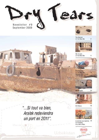
  • 2. DrY Tears 2 TH E H ISTO RY O F TH E A RA L SEA About the Aral Sea disaster. Map of the Aral Sea. Pictures of the Aral Sea. Tourism & travel to the dying Aral Sea. The Aral Sea basin. Where is the Aral Sea? The water that serveth all that country is drawn by ditches out of the River Oxus, into the great destruction of the said river, for which it cause it fal- leth not into the Caspian Sea as it hath done in times past, and in short time all that land is like to be destroyed, and to become a wilderness for want of water, when the river of Oxus shall fail. Anthony Jenkinson, 1558 Process drying of Aral Sea The Soviet scheme was based on the construction of a series of dams on the two rivers to create reservoirs from which 40.000 km of canals would Millions of years ago, the eventually be dug to divert water to the fields. The fields flourished but northwestern part of with such vast areas of monoculture, farmers had to use massive Uzbekistan and southern amounts of chemical pesticides. And with irrigation, salt was drawn to Kazakhstan were covered the surface of the soil and accumulated. When the Tahaitash Dam was by a massive inland sea. built on the Amu Darya near the city of Nukus, there was no water left in When the waters receded, the riverbed to flow to the Aral Sea, hundreds of kilometers away. To the they left a broad plain of surprise of the inhabitants of Muynak, the Aral Sea began to shrink. highly saline soil. One of the remnants of the At first, they assumed it was a temporary condition and dredged a canal ancient sea was the Aral to the receding shore so boats could continue to ply the sea and still Sea, the fourth largest dock at the wharves. But the effluents that did reach the sea were laced inland body of water in the with a deadly mix of salt and pesticides from the cotton fields. Fish popu- world. lations plummeted and eventually, when the canal was 30 km long and the sea continued to move away, the boats were abandoned to lie like The Aral is an inland salt- great leviathans on sands that were once sea bottom. water sea with no outlet. It is fed by two rivers, the The Aral Sea was a rich source of fish. Some 20 species were identified by Amu Darya and Syr Darya. biologists, including sturgeon and catfish. The town of Muynak, located The fresh water from these on the edge of the sea, was a fishing town that also attracted tourists to two rivers held the Aral's its seaside vistas. In the 1950's, the Soviet Union decided the great plains water and salt levels in per- were ideal for growing cotton. The critical factor to make it happen was (Interactive map from wikimedia.org) fect balance. water. Two great rivers feed the Aral Sea, the Amu Darya and Syr Darya. In the early 1960's, the Soviet central government decided to make the Today, Muynak is a desert town more than a hundred kilometers from Soviet Union self-sufficient in cotton and increase rice production. the sea. The only reminders of the once thriving fishing activity are the Government officials ordered the additional amount of needed water to rusting hulks of ships and an ancient fish plant. The sea has shrunk to be taken from the two rivers that feed the Aral Sea. two-fifths of its original size and now ranks about 10th in the world. The water level has dropped by 16 metres and the volume has been reduced Large dams were built across both rivers, and an 850-mile central canal by 75 percent, a loss equivalent to the water in both Lakes Erie and with a far-reaching system of "feeder" canals was created. When the irri- Huron. The ecological effect has been disastrous and the economic, gation system was completed, millions of acres along both sides of the social and medical problems for people in the region catastrophic. All 20 main canal were flooded. known fish species in the Aral Sea are now extinct, unable to survive the toxic, salty sludge. Over the next 30 years, the Aral Sea experienced a severe drop in water level, its shoreline receded, and its salt content increased. Changes to one part of a region often lead to other changes. Here are The marine environment became hostile to the sea life in it, killing the some of the results of the shrinking of the Aral Sea: plants and animals. As the marine life died, the fishing industry suffered. • As water has been drained from the rivers for cotton farming, the sea's water has become much saltier.
  • 3. 3 DrY Tears • As more water has been taken from the rivers, the sea's water level has decreased by over 60%. • Drinking water supplies have dwindled, and the water is contaminated with pesticides and other agricultural chemicals as well as bacteria and viruses. • The farms in the area use some highly toxic pesticides and other harm- ful chemicals. For decades, these chemicals have been deposited into the Aral Sea. When the wind blows across the dried-up sea, it carries dust containing these toxic chemicals. • Lakes and seas tend to have a moderating effect on the climate. In other words, the land right next to a body of water tends to be warmer in the winter and cooler in the summer than land that's not near the water. As the Aral Sea has lost water, the climate has become more extreme. So a centuries old way of life has disappeared in decades. The vast area of exposed seabed is laced with pesticides, so when the wind blows, dust storms spread salt and toxic substances over hundreds, if not thousands of kilometres. It's estimated that 75 million tons of toxic dust and salts are spread across Central Asia each year. If the Aral Sea dries up comple- tely, 15 billion tons of salt will be left behind. Muynak is 210 km (130 mi) north of Nukus. Tourists can take a taxi or a bus to reach Muynak from Nukus. There are options for private accom- modations in Muynak where you can stay overnight.
  • 4. DrY Tears 4 O N TH E BED O F TH E A RA L SEA Pa r t O N E Lake Sudoche (Sudovchin) is the largest body of water in the Amu to believe that such rapid shrinkage cannot be blamed on human activi- Darya delta. When the river was running high, two of its branches, the ty alone, especially as there are serious geological and archaeological Raushan and the Priemuzyak, used to flow into the Sudoche, which indications that the Aral may have undergone a similar process in the was connected by a channel to the Aral Sea. Now the Sea has receded past. The most likely explanation is that a combination of anthropoge- by approximately 150 km, water levels in Lake Sudoche have fallen and nic and natural factors were involved (decreased precipitation and it has split into a number of smaller lakes. The plateau rising in the increased evaporation due to global warming). In addition, there are background is the Ustyurt. The shore area is covered by small shrubs theories about movements in the Earth's crust, and water flowing from and salt, and the soil displays a striking variety of texture and colour. the Aral to the Caspian, which is attributed to tectonic processes or to secret bacteriological research conducted by the Soviet military on Splendid isolation Vozrozhdeniye (Resurrection) Island after 1949. The real reasons why the Saxaul is a plant somewhere Aral has dried up are not precisely clear. between a shrub and a small tree which grows in the desert When I was travelling across the Aral seabed to the former island of and on Asiatic steppes. Its Barsekelmes in 2005, a lady from the Barsekelmes reserve who was root system seeks moisture to accompanying our expedition told us that an ancient settlement had a depth of up to 30m, and been found on the seabed, almost halfway between the island and the some varieties can withstand old shoreline. It was a fairly large settlement, with the remains of stone high levels of soil salinity. In buildings, and ditches and earthen ramparts around them … Although the Large Aral, salt content is we desperately wanted to visit the place, they refused to give us the exact now close to 100 g/litre (ima- coordinates - it was too valuable a find for archaeologists and resear- gine a packet of salt dissolved in a bucket) and even higher in the smal- chers. At that time the very fact that the site had been found was secret. ler, eastern part. In terms of salinity, the Aral Sea is currently second only Now some information about this "Atlantis of the Aral" is beginning to to the Dead Sea, the saltiest water body on the planet. However, Lake emerge. It is direct proof that the Aral was subject to massive, long-term Sudoche used to be a freshwater lake in the spring and became salty only shrinkage in the past. in the autumn. As far as I understood, it is now salty all year round. The white deposits on the ground are not snow, but salt. The 16th relay There is something very The deep appealing about the natural The weather was cold and beauty of this harsh landsca- murky. Expeditions to the pe. Despite the fact that you Ustyurt are few and far bet- can go for weeks on the ween at the best of times, and Ustyurt without meeting a even rarer at the end of living soul, we did not have to November. It is quite possible use our tents once. We were that these pictures are among anxious not to, because the the very few photographs of weather turned out to be -0- Lake Sudoche to be taken at 10°C instead of the expected +0+ 5°C. The relays (radio relay stations) this time of the year. are positioned at 50 km intervals and were previously used to transmit broadcast signals to outlying villages. With the development of satellite In place of algae television and the disappearance of settlements from the Ustyurt, these wonders of modern technology have long since become redundant. The main reason for the demi- Nearly all of them are uninhabited, with the exception of a few which se of the Aral is thought to be have been converted for special purposes - usually for guarding a gas the reckless exploitation of pipeline. Coming from Nukus, the closest relay station on the Ustyurt the water that flowed into it Plateau is number 16; it was here that a guard gave us shelter on the first from the Amu Darya and Syr night of our expedition. On the following days we got nearly as far as the Darya rivers and the excessive 21st relay station (the only other inhabited station turned out to be the amounts of water diverted for 19th, although we did not spend any more nights at relay stations). All in cotton irrigation. However, all our jeeps covered about 1000 km on the Ustyurt in four days. many specialists are inclined
  • 5. 5 DrY Tears Pa r t TW O Pa r t TH REE The origin of the word Sudoche is curious. Despite the obvious asso- The south-western region of the Aral Sea, the salt flat Borsa Kelmas. ciation, the name of the lake has nothing to do with the fish called In Uzbek it means "he who goes does not return". The edge of the "sudak" (pike perch). As our expedition leader told me, in Uzbek the shore is really marshy, but the surface itself is stable and hard. The lake is called "Suvdochin" from the word for water (suv) and the word main thing is to force a way through. And then return. for sincere (chin). A salty supper Along the road with clouds We got back - up to our knees All the points along our route in dirt, exhausted but happy. are linked with sunrise and We fooled around in the sunset. We had to get up at bright sunshine for a good five o'clock in the morning if half hour, now and then tas- we wanted to get to the shore ting the salt. A genre photo. in time for sunrise. And then it would take us nearly an hour to find our way down from the "chink " and get to the photography sites we had marked out the evening before. Good morning sunshine Badwater Uzbek style Chink (literary form; Kazakh. and Turkm. chin), a precipice or ledge on the edge of a plateau or small residual butte. Term widespread in Kazakhstan, Turkmenistan There is still a factory on the and Uzbekistan. Most frequently used to describe cliffs on the Ustyurt Plateau. lake - perhaps for salt, per- A chink can reach 300 to 350m in height. It is caused by erosion, denudation or haps for soda. The factory is tectonic deformation. clearly very secret, because there is not even anything Layer cake about it on Google. The GPS Lake Sudoche used to be the coordinates are given below, largest water body in the but there is no factory on the delta, with a surface area of map. 350 sq. km. and a depth of up to 3 m. Nowadays the lake is http://maps.google.com/maps?ll=43.3808,58.0025&spn=0.02,0.02&t=k so shallow that you could pro- bably wade across it on foot. And yet the map is completely up to date, and gives a pretty accurate pic- ture of the Aral Sea within its current shores. On the edge of the world A panorama collage, 200x134 No fish here degrees, 17 frames. The pro- In the 1950s the fishing village portions are roughly correct, of Urga, on the shores of Lake but they look unbelievable. Sudoche, was home to a The angle is too large + dis- couple of hundred people. tortion from the wide-angle Our guide, October, told us lens. I have been told off that he used to have his club about the geometry, but I and his post office here. The can't help myself - I like this last inhabitant left in 1971. photograph, precisely becau- Nowadays hardly anything se it is so weird. remains.
  • 6. DrY Tears 6 Pa r t F O U R Pa r t F IVE This is Chimbergen, our dri- ver. The second driver was called Bakbergen. The ending of both names means " he who has given " . Bakbergen - " he who has given will provide " , i.e. he who gave this child (God) will provide. And Chimbergen means " he who has truly given" (remember Sudovchin, "suv" means water and "chin" means Until 1961, when the Aral truth). Sea began to dry up, its water level stood at the Our guide was called October, after the revolution. A good man too - a 53.40 m. mark, and annual variations were never more than + /- 0.4 m. historian and archaeologist. I am starting to sound like the narrator of By 2003 the level had dropped to the 30.90 m. mark, i.e. by more than my favourite film, "Abdullahjan" (a Russian sci-fi comedy of the early 22 m. Moreover, the water level fell 1.26 m in 2002 and 1.14 m in 2001. 90s): "This is the head of our kolchoz, a good man" . Thanks, guys! These are the most recent data, which can be found on the Internet. Extrapolating from these figures, the Aral has probably fallen by at The most banal thing you can say when you are on the eastern chink least by another 5 m. by now, and the total drop in water level is like- of the Ustyurt Plateau is "this used to be the bed of the Aral Sea". I ly to be in the region of 27 to 30 m. It is not difficult to imagine this myself used to imagine the seabed everywhere, even in places where figure, it is roughly equal to the height of a 9-nine storey block it never was. The phrase runs through the comments on our video of flats. notes. And yet when it comes to the real seabed, which really used to be at the bottom of that sea, words fail me. Although the cliff in the photograph is high, it is clearly less than two sto- reys. In the upper right-hand corner we can see the sea. The differential Uzbek canyons between the current shore and the bottom of the cliff is not significant, since both points are on the flat surface of the former seabed. This means that the place where I took the photograph used to be under water too. And here is the far cliff, foreshortened differently and with a large zoom ratio. At the shoreline, the water is foaming The three black like in a wash basin, and white flakes are dots in the bottom flying along the bank. The sea is very right-hand part of the frame are cows. Our guides told us that this was shallow here, as can be seen from the not the first time they had seen them, they had obviously strayed from waves. I went in 30 m, but the water the herd. It is not at all clear how they manage to survive - after all there only came up to my ankles. The bottom are no people, no water and no food in these parts. is unpleasantly slimy and squelches like a bog. It was pretty cold, about 0° plus chill factor, but you understand why I You can see the scale from the tracks of couldn't not go for a swim; my health the jeeps in the background - this used did not suffer, thank God. to be under water, and now you can drive across it by car. And this is what the last 100-200 m. of road looked like before it came up
  • 7. 7 DrY Tears Pa r t SIX against a rocky precipice. The same precipice from where you get the I realise that everyone is fed up with photographs of the Aral Sea. I am view of the sea and where the first of this series of photographs tired of them myself, but if I do not finish off the material now, it is was taken. likely to hang around on my desk for an awful long time. And anyway, how can you photograph the Aral without the ships of the desert? Loy takir Although we dragged ourselves down to the old jetty at the crack of dawn, there was no dawn to be seen. Ghastly weather, literally a "grey In Turkic languages " loy" mist". As a result the photos you see are just for the record, but I deci- means clay and " takir" means ded that the series would not be complete without them. smooth or level. There, that's what you get when you go del- Until the 1960s the town of Muynak was a port on the island of the same ving in dictionaries. The takir name, and could only be reached by boat or plane. They say that when is a type of relief in sandy, clay the sea first started to shrink, the water suddenly retreated 20 m. in one and stony deserts and semi- night. The following morning, people ran after the sea and wept. After deserts in tropical and subtro- a while they tried to dig a channel from the port to the shore, but the pical zones. The surface is a water retreated faster than they could dig. Nowadays this place is more hard crust of clay and salt, than 100 km from the sea. What the current inhabitants do remained a broken by polygonal fissures. In the spring takirs are usually submerged mystery to me, but it was here that I saw the full tragedy of the Aral. On by water, turning into temporary lakes. Takirs can be found in Central the Ustyurt, far from civilisation, what is happening seems more like a Asia, Kazakhstan, Mongolia, the Middle natural process. But where that process has destroyed an established East, North America and Australia. way of life, and ruined people's lives - then the tragedy is real. Hard to believe, but some 40 to 50 years On the bed of the Aral Sea. Route and team ago this really was the seabed. There will probably be a full report on our photo expedition to the Aral Sea later on. But in the mean- time I would like to say little bit about our team, our route and the jour- ney itself. This note draws a line, so to speak, under my six previous series of photos with commentaries. I loved the idea of going to Uzbekistan at once. As always, everything happened spontaneously and very quickly. A classic beginning - there I was, sitting at home, not planning to go anywhere. But then I came across the plan of the route which Jahangir aka had worked out on " Friends Lent " and I was immediately hooked. I spent a few days trying to work out how I could get away, and then a day after that I already had the "Uzbek airlines" tickets in my pocket.
  • 8. DrY Tears 8 The following day Jahangir came up with some unexpected news. There And here is our team. had been a telephone call from the Uzbek Civil Defence Ministry - just at the time when we were planning to roam the Ustyurt plateau, they were From left to right: expecting some sort of spacecraft to fall to land. The expedition quickly back row - Chimbergen, had to be switched to the week before. Because a week later we would Jahangir, Vadim, simply have frozen to death. With all the members of the expedition Khurshid, October; completely booked up, it is a wonder that the journey was not called off front row - Pavel (me), then. Bakbergen The aim of the expedition was quite simple: to look and to take photo- graphs. We were chiefly interested in the Aral Sea region, which is still little known. Despite the unusual processes which are occurring on the Chimbergen and Bakbergen Ustyurt, human beings are rarely seen there. However many scientists The best, the fairest and most fearless drivers of UAZ and Gelentwagens and researchers may have visited, information is still scarce. We were in the world. The ending of both names means "he who has given" . drawn like a magnet by the beauty of this arid country; this unique 20th- Bakbergen - "he who has given will provide " , i.e. he who gave this child century phenomenon gave us no peace. We wanted to see the Sea which (God) will provide. And Chimbergen means "he who has truly given" . no longer exists. And, clearly the height of madness, to see it in winter, at a time of the year when no normal person would dream of going there. October Dospanov I have heard some exotic names, like Vilen (V.I.Lenin), Dazdraperma The Aral can still be seen from space. Judging from our GPS markers, (Hail to the first of May) and Avantgarde, etc. But this was the first time Google maps give a fairly accurate reflection of the general picture and I had met a real October, named after the revolution. He was an acade- the current extent of the sea. mic, amongst other things an archaeologist and historian. A great guy, and also our guide. He knows so many interesting things you could lis- ten to him for hours. Khurshid Juraev An economist and banking specialist, able to chat on his mobile phone even when there is no connection. Generally a friend and comrade, apprentice photographer and irreplaceable video operator. In Uzbek his name means "cheerful" , which is completely appropriate to its owner's character. Vadim Onishchenko The final route does not look the same as we planned, because reality A great nature photographer and winner of the "Golden Turtle " award. A intervened and necessitated a few corrections. First of all it was very master of international dispute from Israel. The meaning of this name is cold. We had been had been counting on 0+10°, but the weather we a matter of dispute. Some researchers think it is Persian, but the majo- encountered reversed the sign: 0-10°. Not to mention the wind - the wind rity incline to the view that it comes from the old Russian word "vaditi" , is a permanent resident on the Ustyurt and never leaves. However, fate meaning "discord, dispute " . Hard but fair. looked kindly on us, and we never had to spend a night under canvas. Jahangir We flew into Nukus on 23 November 2007. Our first night we spent in a We got to know each other on a photo site - a long time ago. One day hotel à la half a star, as a sort of decompression stop. Our second warm Zhenya (Jahangir) came to Moscow and called me up. Our meeting, night came courtesy of the guard at the 16th relay station. The third we need I say, ended at my place, with the drinking of much dry red wine. spent in a hostel for workers at the salt factory on Lake Borsa Kelmas, And a month later we were already sitting at table in his house in the sub- which is home to about 10 to 15 people. What sort of factory it was and urbs of Tashkent. The place is called "Jannatmakon" , which means "val- how it got there, we never found out. The fourth night we spent in ley of paradise " . Muynak with relatives of our guide. And on the evening of the 27th we were already in the ancient town of Khiva, but that is another story.
  • 9. 9 DrY Tears Is it time for me to become a translator? I remember I could even unders- tand what the Uzbeks were talking about as we were driving across the Ustyurt in our jeeps. "Blah blah blah. Car. Blah blah blah. Route. Blah blah blah" . " Oh, Pavel, sorry, we were talking in Uzbek. " " No problem. I understand anyway. " "You understand?" "Sure, I understand. You were talking about cars. " And now, for the sake of completeness, Then there is Jahangir. A name to conjure with, you have to admit. In we obviously need some sort of a story. Farsi "Jahan" means world and "gir" means to conquer; in Turkish Something like: our jeeps broke down and we got stuck in a quicksand "Jahan" means world and "gir" means to circle. And that is spot on, and if it had not been for our satellite phones, we would certainly have because our Zhenya/Jahangir has been halfway round the world and has died. But nothing like that happened. And what is more, we depended already been to 38 countries. The devil! on each other and left our satellite phones at home. In actual fact, the idea of a photo expedition to the Aral was Jahangir's. Well, there was one story. It goes like this. We woke up in Muynak at the It was he who organised everything, he invited us all and became our lea- crack of dawn. Every day we woke up long before dawn, because we were der. Thanks, buddy! on a photo expedition. That means that the most interesting things hap- pen when the sun is rising or setting. And so everyone was getting into Pavel Kosenko the jeeps, but Chimbergen was nowhere to be found. We started looking for him. Jahangir went running round the yard shouting: "We are going A few photographs for the album. to miss the sunrise, you good-for-nothing son-of-a-bitch!" . Suddenly the After all, it was a photo expedition. owner of the house appeared from behind a corner and came up to me and said: " Have you got a torch?" . I gave him my torch, the sort you strap Remember - this is salt, not snow. Lake on to your forehead with a rubber band. The owner disappeared into the Borsa Kelmas means "he who goes will darkness. And then five minute minutes later Chimbergen emerged not return" . triumphantly from the loo. Quite pleased with himself, grinning from ear to ear. The torch on his forehead and a long wooden stick in his hand. At the end of the stick a lump of shit with a mobile phone inside it. But how did he fish it out? We were in time for the sunrise after all, although this time it was a bit messy. And in the evening of that day we were already resting our aching limbs The three dots at the bottom are me, in a three star hotel in the ancient city of Khiva. But that is another story, Vadim and Jahangir. the second part of our journey. The chronology of the Aral can be found on www.kungrad.com . As I said, I couldn't not bathe in the Aral. I would never have forgiven myself. You had to put up with extremes, after all it was 0° and windy.
  • 10. DrY Tears 10
  • 11. 11 DrY Tears U N U SU A L WA VE EVA P O RATI O N C LO U DS O VER O F TH E A RA L SEA TH E A RA L SEA In the 1960s, the Soviet Union under- Distinctive lines of clouds took a major water diversion project on stretch out from the shore the arid plains of Kazakhstan, of the Aral Sea in this photo- Uzbekistan, and Turkmenistan. The like image captured by the region’s two major rivers, fed from Moderate Resolution snowmelt and precipitation in far-away Imaging Spectroradiometer mountains, were used to transform the on NASA’s Aqua satellite on desert into fields for cotton and other March 12, 2009. While wave crops. Before the project, the two rivers clouds like this are not unu- left the mountains, cut northwest sual, this particular pattern through the Kyzylkum Desert—the over the Aral Sea is highly Syrdar’ya to the north and the Amudar’ya in parallel to the south—and unusual. The clouds conform exactly to the shape of the western shore. finally pooled together in the lowest part of the desert basin. The lake they made, the Aral Sea, was once the fourth largest lake in the world. Wave clouds typically form when a mountain, island, or even another mass of air forces an air mass to rise. The air cools as it rises, and if Although irrigation made the desert bloom, it devastated the Aral Sea. there is moisture in the air, the water condenses into clouds. Once the This series of images from the Moderate Resolution Imaging air has gone over the obstacle, it sinks again. The air warms as it drops, Spectroradiometer (MODIS) on NASA’s Terra satellite documents the and the cloud dissipates. Like ripples on a pond, the wave motion changes in the the Aral Sea throughout the past decade. At the start of continues, and the air rises and drops again and again until eventually the series in 2000, the lake was already a fraction of its 1960 extent the wave dissipates. The result is a line of clouds marking the crests of (black line). The Northern Aral Sea (sometimes called the Small Aral the wave, separated by clear areas in the troughs of the wave. Sea) had separated from the Southern (Large) Aral Sea. The Southern Aral Sea had split into an eastern and a western lobe that remained In this case, the western shore of the Aral Sea clearly created the distur- tenuously connected at both ends. bance needed to generate the initial wave motion. But what was the dis- turbance? There are several possibilities. First, the waves could be caused By 2001, the southern connection had been severed, and the shallower by a change in wind speed as the air moved eastward over the sea. Air eastern part retreated rapidly over the next several years. Especially moves slowly over land, slowed by plants, changes in elevation, and other large retreats in the eastern lobe of the Southern Sea appear to have rough features. When the air reached the sea, the surface it encountered occurred between 2005 and 2006, and again between 2007 and 2008. was smooth, and the air near the surface would have moved faster. The air The final image in the series is from the spring of 2009. Blowing dust above it, however, would have continued to move at the previous pace. (salt-laden sediments) covers a large part of the sea. Imagine a jogger who unexpectedly steps on a patch of ice: his feet move forward faster than his head, and he falls back as his legs slip forward As the lake dried up, fisheries and the communities that depended on under him. The air experiences much the same motion. The lower layer of them collapsed. The increasingly salty water became polluted with fer- air (in contact with the smooth surface of the water) moves more quickly tilizer and pesticides. The blowing dust from the exposed lakebed, than the air above it, pushing the lower layer of air up. This motion could contaminated with agricultural chemicals, became a public health have created the wave that generated these clouds. hazard. The salty dust blew off the lakebed and settled onto fields, degrading the soil. Croplands had to be flushed with larger and larger Another possibility is that the shoreline is elevated above the water. The volumes of river water. The loss of the moderating influence of such a Aral Sea has been steadily shrinking. What remains is the deepest por- large body of water made winters colder and summers hotter and drier. tions of the sea. It is possible that the western shore is distinctly defi- In a last-ditch effort to save some of the lake, Kazakhstan built a dam ned, and that there is a drop to the surface of the water. This change in between the northern and southern parts of the Aral Sea. Completed in elevation would cause the surface air to drop suddenly, which could 2005, the dam was basically a death sentence for the southern Aral Sea, also initiate wave motion. Both factors, the air speed and the shoreline, which was judged to be beyond saving. All of the water flowing into the may in fact be working together to influence the shape of the clouds. desert basin from the Syrdar’ya now stays in the Northern Aral Sea. Regardless of how they formed, the result is a beautiful fan of white Between 2005 and 2006, the water levels in that part of the lake over the emerald water of the Aral Sea. rebounded significantly and very small increases are visible throughout the rest of the time period. The differences in water color are due to NASA images courtesy Jeff Schmaltz, at NASA GSFC. Caption by Holli changes in sediment. Riebeek. Thanks to Gala Wind and Tom Arnold for image interpretation.
  • 12. DrY Tears 12 ARAL ATLANTIS Le chemin serpentait entre les dunes du désert. Sur des kilomètres, Les travaux étaient pratiquement finis, pas une âme, les oiseaux, même, ne volent pas jusqu'ici. quand j'ai décidé de faire une dernière « Espérance », l’indicatif d’appel de notre voiture, premier contact : la fouille des briques empilées autour du voix du chef de notre expédition, Dmitri Voyakin, collaborateur scien- mausolée, - déclare Dmitri. - nous com- tifique à l’Institut d’Archéologie Marguilan, retentie à la radio, il porte mencions juste à creuser quand nous notre attention sur le fait que nous roulions depuis déjà 10 minutes sur sommes tombés sur un mur, parfaite- le fond de la mer d’Aral. ment conservé, du portail. Comme il s'est avéré, la mer avait rongé le mausolée de Chacune des journées de cette expédition commencera de la même tous les côtés, et le mur du portail s'est effondré entièrement. Les briques sont manière : les archéologues accompagnés de notre reporteur seront en tombées du haut, couvert de sable, l'eau les a emportées, ce qui a jusqu'à présent par- avant poste. faitement préservé la glaçure de l’artefact (vitrage), dont l'analyse révèle de nom- breux secrets des colonies de peuplement dans le fond de la mer d'Aral. Trésors au fond de la mer Tu iras – tu ne reviens pas Il y a plusieurs décennies, l’eau s’ébrouait ici, des poissons nageaient et des navires circulaient. Car la colonie a été retrouvé près de Maintenant, c'est un immense espace sans vie, couvert de sables salés et la célèbre île de Barsakelmes (en de coquillages cachant de nombreuses «belles découvertes." kazakh il signifie «tu iras – tu ne reviens pas»), une décision a été En 2001, les chasseurs du village Karateren sont tombés accidentellement sur prise de maintenir un peu d'explo- une inhumation antique à proximité des îles de la mer, autrefois appelées ration sur l'île même, à la recherche Barsakelmes. Les archéologues sont intéressés par cette découverte étrange. des objets de sites archéologiques, À la suite de l'expédition, des scientifiques de l'Institut d'Archéologie sur ce point fatidique, composé de nombreuses légendes et d’histoires qui d'Almaty, A. Marguilan et des étudiants de l’Université nationale Korkit-ata de décrivent les incidents bizarres et obscurs impliquant un changement dans Kyzylordine, ont ouvert un mausolée (qu'ils ont appelé Kerderi), autour le cours normal du temps physique. Ils disent qu’un jour quelques person- duquel se trouvent de nombreuses tombes. Les parcours des expéditions nes se sont éloignées de la côte en marchant pendant une demi-heure dans suivantes sont devenus assez sensationnelles, à 25 kilomètres du mausolée le « brouillard blanc », quand ils sont revenus, ils ont été surpris d'appren- Kerderi on a trouvé un autre mausolée et l'ancienne colonie. dre qu'ils se sont absentés … un jour. Et encore mieux, certain habitants du coin, sont persuadé qu'il existe … une base secrète d'OVNI. Sur le territoire de la colonie de 6 hectares, nous avons trouvé 15 grosses En 1939, l'île est devenue un sanctuaire sur le territoire duquel se sont meules, des morceaux de poteries et des rassemblé des oiseaux, des animaux rares et des gens. monnaies en argent, des ornements en fer rouillés, ainsi que des fragments de L'eau a disparue - et la vie aussi … fours, qui produisaient des briques, - raconte Dmitry Voyakin. - On a égale- Nous avions espéré trouver sur l'île, les vestiges d'un village néolithique (âge de m ent trouvé un réseau d'irrigation pierre), - dit Dmitry Voyakin. Sur les photographies aériennes, il existe mani- antique. À ce jour, il est resté le canal festement plusieurs collines, ce qui pourrait être des tumulus. L'exploration initiale principal et les canaux de sortie. L’analyse des sols a montré que les gens qui a montré que cette région devrait être étudiée plus en détail. Nous espérons décou- vivaient ici, cultivaient le riz. Le grand nombre de meules montre que le rendement vrir encore quelques villes. du sol était productif. De l'île Barsakelmes nous sommes revenus sains et saufs. Cependant, la sensation Les fouilles du mausolée ont également apporté beaucoup de découvertes. Dans le de quelque chose d'irréel n’a jamais quitté notre équipe pendant tout le temps que hall central on a retrouvé des cercueils de bois, mais le plus intéressant, c'est que les nous sommes restés là-bas. Barsakelmes c’est un endroit véritablement mystique. inhumations ont été effectuées selon le rite musulman, aucun mobilier funéraire n’a Comme, cependant, la région entière de la mer d'Aral. Les trouvailles au fond de la été retrouvé sur place. Seule, une tombes était remplie de boucles d'oreille en or. mer, donnent lieu à de nouveaux débats sur l'écologie du territoire de la mer d'Aral. Mais une sensationnelle découverte attendait les archéologues au dernier jour de Il s'avère que les catastrophes écologiques influencent la région depuis l'antiquité. l'expédition. La colonie retrouvée est un témoignage. La ville a été construite au moment de l'assèchement de la mer, puis l'eau a tout avalé. Les archéologues sont convaincus que le fond d'Aral cache encore beaucoup de mystères.
  • 13. 13 DrY Tears CITY « SOLEIL » A l'aube du matin du mois de septembre, les quatre voitures chargés C’était l’image d'un homme nu! Excellent, il s'agit du deuxième exemple retrouvé! comme des chameaux et excités par les hommes scientifiques, se sont – a exclamé avec enthousiasme Dmitri Voyakin. - L'année dernière, nous lancés dans la direction de la région de Qyzylorda. Un groupe d'archéo- avons trouvé ici le premier artefact. Ces plaques sont cousues sur des habits des logues à la recherche de nouveaux sites archéologiques s’est lancé filles à partir de leur maturité sexuelle - m'explique t'il. dans une expédition passionnante sur les chemins de la Grande Route de la Soie. Les scientifiques se sont concentrés sur les trois objectifs : Je pense sans aucun doute, que nous trouver et identifier la Cité perdue des Rois, Djouvara, afin de contin- nous sommes approchés des secrets per- uer des fouilles d’un grand site d'Aral-Asar, qui a été retrouvée au fond dus de l'histoire de la Ville des Rois ou Sun City - a conclu l’académicien de la mer d'Aral dans la dernière année, et de faire des insulaires des Baipakov. A premiére vue, d'après sa archéologue de l’île de Barsac-Kelm_s. En général, le voyage promet taille, son système complexe de fortifi- d'être intéressant. Après plusieurs jours de voyages, nous sommes cation et de la composition intérieur, ça arrivés à notre premier but. devait être une ville très importante, elle est très impressionnante. Les « Cités lacustres » sont les monuments his- Trésors au fond de la mer toriques et culturels des Turcs anciens et le plus mal étudié à ce jour. Et, bien sûr, le plus grand intérêt parmi eux c'est, exactement, Djouvara. Djouvara – est l'une des plus mystérieuse des anciennes villes du Kazakhstan, affirme le chercheur Dmitri Voyakin de l'Institut d'Archéologie A. Pendant deux jours, les archéologues avaient ramenés de la surface de Margulan, ses secrets inquiètes les esprits des nombreux scientifiques. Les cette grande ville environ cinq kilogrammes d'objets en bronze et en recherches archéologiques globales actuelles, je pense, seront le début d'un grand argent : pièces, boucles de ceinture, bijoux, plaques. En outre, a été travail sur, les soi-disant, colonies de marécages. retrouvé de nombreux fragments de céramique, et sur le lieu des recherches, les scientifiques peuvent observer l’architecture. En creusant plusieurs fosses, un groupe d’archéologues a commencé à examiner Fantastique! Telle quantité d'objets trouvés, nous n'en n'avons pas eu autant des la situation stratigraphique de la ville, autres anciennes villes (partage son opinion un membre de l'expédition, l'autre s’est préparé pour la collecte de Arman Umarhodzhiev). On ne peut que deviner ce qui se cache derrière m atériels de levage de surface de ses secrets et quels trésors sont encore cachés sous la terre. Djouvara. Moi aussi, j'ai voulu essayer d’être une archéologue. J’ai posé mon Si tout va bien, des fouilles sur le site peuvent être recommencées à regard sur les pieds et me suis lancée à la grande échelle l'année suivante. Et Sun City Djouvara vous fera découvrir recherche des trésors. Je voudrais vous une nouvelle page dans le passé historique du Kazakhstan. dire que c'est une occupation passionnante! On oublie le temps passés et le chemin parcouru. Tout à coup, un petit objet vert a attiré mon attention. C’était incroyable Nadejda Plyaskina, ! Une vraie bague. Un peu à l'écart, j'ai remarqué quelque chose d'autre. Et voilà, Région de Qyzylorda - Almaty je tiens dans mes mains un bracelet de femme. N’étant pas encore revenue d'une telle chance, je suis tombée sur un trésor de pièces de monnaie. Bravo, tu es une véritable archéologue! – m’encourage l’académicien Carl Baipakov. – Il faut que vous restez ici jusqu'à la fin de l'expédition (Il riait). En tenant dans les mains une autre découverte, j'ai pensé : “ Je me demande comment ils étaient, les habitants de Djouvara? A quoi ils pensaient ou rêvaient? Quoi ou qui les a obligés à quitter cette ville florissante?” . Selon les données préliminaires, les premières constructions ont paru ici au début de notre ère. Au début de X siècle Djouvara atteint son apogée. Et après quelques centaines d’années ou un peu plus, la ville des Rois est tombée en déca- dence. Dmitri Alexéevitch, regardez ce que j'ai trouvé – s’est exclamé un participant de l'expédition, Alik Orazaliev, en tenant dans la main un objet étrange.
  • 14. DrY Tears 14 LE MYSTÈRE DES TEMPÊTES DE P O U SSIÈRE DE LA MER D ’A RA L De plus en plus souvent, de violentes tempêtes de poussière balaient pour atténuer les conséquences de ces tempêtes de poussière.” des régions entières d’Asie centrale. Avec l’assèchement de la mer d’Aral, le vent emporte davantage de sable avec du sel pollué et des A 300 km de la mer d’Aral, les chercheurs se rendent dans cette station produits chimiques empoisonnés. Les tempêtes de poussière accen- météorologique pour installer des pièges à poussière. tuent la pauvreté et répandent des maladies. Les particules capturées pendant les tempêtes de poussière sont ensui- Il y a 40 ans seulement se trouvait ici une mer. C’est à présent l’un des te pesées, mesurées et analysées. Les scientifiques estiment que les tem- lieux les plus secs du Kazakhstan et de l’Asie centrale. C’est la raison de pêtes peuvent transporter jusqu‘à 400 kg de poussière par hectare la présence de ces chercheurs européens. chaque mois dans des endroits comme celui-ci. “ Le lac d’Aral était une île de fraîcheur entre deux déserts, le Karakoum et le “ Nous avons déterminé les tailles de grains de poussière et aussi leur composition Kusulkoum, explique Christian Opp, géophysicien de l’Université de minérale à l’aide de techniques comme la radiofluorescence, rapporte Christian Marburg, en Allemagne. Elle était un réservoir d’eau énorme, avec un habitat Opp. Avec ces informations, nous avons pu établir les régions de provenance. et un biotope très riches, munis d’une grande biodiversité. Maintenant, on appel- Nous avions une hypothèse : puisque ces poussières proviennent en partie du fond le l’ancien lac le “Aralkoum”, le désert d’Aral. On en voit des signes partout : le lac du lac d’Aral, les taux de sel doivent être relativement élevés. Et nous en avons eu est devenu un autre désert.” la confirmation : le sel de la Mer d’Aral est bien arrivé jusqu’ici.” “ Le principal problème avec la baisse du niveau de la mer a été la disparition d’es- La recherche des poussières se poursuit à 1 300 km de là, au sud-ouest. pèces de poissons de grande valeur, ajoute Oleg Semedov, physicien à Nous voici à Almaty, l’ancienne capitale du Kazakhstan. Au Centre natio- l’Institut de recherche kazakh de l‘écologie et du climat. Cela a conduit nal de recherche spatiale, les tempêtes de poussière sont observées de beaucoup de pêcheurs et de personnes vivant sur la côte à perdre leurs emplois. près, grâce à des satellites. Mais il y a eu un second problème. Ce qui était le fond de la mer est à présent un dangereux mélange de poussière, de sels, d’aérosols et de produits chimiques qui Ces tempêtes constituent un élément clé du changement climatique. s’envolent avec le vent. Leur propagation a détérioré la végétation à 150 km alen- Répandue dans l’atmosphère, la poussière rafraîchirait la surface des tour. C’est ainsi que la désertification de toute la région a commencé.” océans et empêcherait le déclenchement d’ouragans notamment. Voilà comme se présentait la mer d’Aral en 1960. L’utilisation massive et Les images satellites montrent qu’ici, en Asie centrale, les tempêtes de impropre de ses affluents pour l’irrigation l’a réduit à trois plus petits poussière contribuent à assécher des régions déjà très désertique. lacs. La mer a perdu quelque 50 000 km2. L’impact social et humain de ce phénomène est terrible. “ Depuis l’an 2000, la poussière provient d’une superficie de la région d’Aral tou- jours plus grande; l’intensité et la fréquence des tempêtes de poussière augmen- Le chômage et la pauvreté sont criants le long des anciens rivages. Des tent également, témoigne Lev Spivak directeur du centre national de tech- maladies comme la tuberculose ou l’hépatite sont ici deux fois plus nologie et de recherche spatial. Auparavant, les émissions se faisaient surtout répandues que dans les régions alentour. Et puis, il y a le vent. vers le nord-ouest. A présent, elles sont surtout dirigées vers le sud; cela signifie que chaque année, de nouvelles superficies de terres sont polluées par le sel du Fréquemment, des tempêtes de poussière traversent l’ancien fond fond marin de l’Aral. ” marin, emportant au loin du sable, du sel et des produits chimiques uti- lisés pour l’agriculture. Un cocktail empoisonné que respirent chaque Les chercheurs souhaitent également comprendre les dynamiques jour les habitants. internes des tempêtes de poussière, leurs volumes, leur vitesse et leur densité, la façon dont elles se forment et s‘éteignent. Ce sombre phénomène est à présent examiné à la loupe par une équipe de chercheurs européens au sein du projet “Calter”. Pour ce faire, ils reproduisent de petites tempêtes de poussière dans un tunnel à vent artisanal, équipé de laser et remplis de poussière du désert “ D’abord, nous voulons comprendre ce qui se passe avec les tempêtes de poussiè- et de sable. re ici en Asie centrale et particulièrement autour de la mer d’Aral, parce que les dernières études se sont arrêtées après l’effondrement de l’URSS, explique Leah “ Ces expériences nous ont permis de comprendre quelle quantité de sable s’envo- Orlovsky, coordinatrice du projet Calter. La poussière ne connaît pas les fron- le avec le vent à différentes vitesses, selon Oleg Semedov. Nous savons à pré- tières politiques, elle peut virtuellement se déplacer vers l’Europe ou d’autres sent que les particules de sable avancent comme une avalanche ; les plus petites régions du monde. Nous voulons savoir quelle quantité de poussière et de sel s’en- particules se soulèvent et entraînent de plus grosses particules qui en entraînent vole, leur composition, leur direction. Ensuite, nous voulons proposer des solutions elles-mêmes de plus grosses etcetera. Nous savons aussi que la concentration
  • 15. 15 DrY Tears maximum de sable s‘élève à quelques fractions de millimètre. Plus il se trouve haut dans l’oeil de la tempête, plus la densité de poussière est faible. Des équa- tions mathématiques nous aident à calculer la masse totale de sable emporté à différentes hauteurs et dans différentes vitesses de vents.” De retour au désert, les scientifiques étudient différents sites géolo- giques. Ils sont convaincus qu’autour de la Mer d’Aral, une désertifica- tion due à l’action de l’homme amplifie les tempêtes de poussière, et assèche les régions alentour. Un cycle infernal contre lequel existent quelques solutions préventives. “ Nous savons à présent que la quantité réelle de poussière par unité de surface mesurée en tonne par année et par hectare diminue, résume Leah Orlovsky. Nous connaissons la composition chimique de cette poussière ; nous savons aussi d’où elle vient. Nous avons donc beaucoup de nouvelles données pour proposer quelques solutions préventives. Le meilleur moyen de préserver la région de la Mer d’Aral de toute dégradation est de cultiver des plantes locales. Non pas dans tout l’ancien fond marin mais sur de petites îles vertes ; ces plantes retiendraient la sur- face et il y aurait beaucoup moins de poussière emportée.” Les scientifiques espèrent aussi que leur travail aidera à mettre en place un système d’alerte des risques écologiques en Asie centrale.
  • 16.
  • 17. Menuiserie A. Gombeer Menuiserie general • Ebenisterie • Tout travaux interieurs & exterieurs sur mesure • Chassis • portes • faux plafonds • creation de meubles • placards • cuisines • Conception & plans • Devis gratuit Grand’Rout 12•1630 Linkebeek Tel. 023772081 GSM. 0472602057 Chaussée de Forest, 257 • 1190 Bruxelles (Belgique) Tel: 02/534.32.47 (Joignable à partir de 17h00) Fax: 02/534.63.26 Gsm: 0478/55.59.27 (Joignable à partir de 17h00)
  • 18.
  • 19. THANKS TO Bergensesteenweg 70 • B-1500 Halle Tel. +32 2 361 36 86 • Fax +32 2 360 37 97 www.tcctechnical.be Weiveldlaan 35 C • 1930 Zaventem www.trendhopper.be zaventem@trendhopper.be SPONSORS IN N ORWAY
  • 20. Vous trouverez chez nous toujours le véhicule adéquat dont vous avez besoin, en ligne ou chez une de nos agences. Surwww.mols.be nous présentons les dernières nouvelles et vous avez la possibilité de réserver en ligne un de nos 180 véhicules (voitures de personne, camionnettes, camions, versions spéciales…). Location de véhicules Mols sa • Parc Industriel 24 • 2235 Hulshout 015 / 22.52.80 • info@mols.be ©Eve Van Soens