
Recomendados
Más contenido relacionado
La actualidad más candente
La actualidad más candente (19)
Destacado
Destacado (15)
Similar a Script clases ide bd espacial
Similar a Script clases ide bd espacial (20)
Último
Último (20)
Script clases ide bd espacial
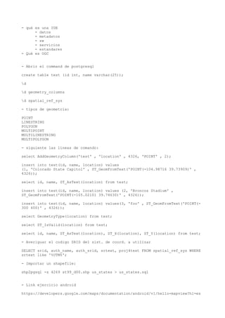
- 1. - qué es una IDE - datos - metadatos - sw - servicios - estandares - Qué es OGC - Abrir el command de postgresql create table test (id int, name varchar(25)); d d geometry_columns d spatial_ref_sys - tipos de geometria: POINT LINESTRING POLYGON MULTIPOINT MULTILINESTRING MULTIPOLYGON - siguiente las lineas de comando: select AddGeometryColumn('test' , 'location' , 4326, 'POINT' , 2); insert into test(id, name, location) values (1, 'Colorado State Capitol' , ST_GeomFromText('POINT(-104.98716 39.73909)' , 4326)); select id, name, ST_AsText(location) from test; insert into test(id, name, location) values (2, 'Broncos Stadium' , ST_GeomFromText('POINT(-105.02101 39.74630)' , 4326)); insert into test(id, name, location) values(3, 'foo' , ST_GeomFromText('POINT(- 300 400)' , 4326)); select GeometryType(location) from test; select ST_IsValid(location) from test; select id, name, ST_AsText(location), ST_X(location), ST_Y(location) from test; - Averiguar el codigo SRID del sist. de coord. a utilizar SELECT srid, auth_name, auth_srid, srtext, proj4text FROM spatial_ref_sys WHERE srtext like '%UTM%'; - Importar un shapefile: shp2pgsql -s 4269 st99_d00.shp us_states > us_states.sql - Link ejercicio android https://developers.google.com/maps/documentation/android/v1/hello-mapview?hl=es