Data Sharing Principles in Madagascar/Frédéric Joël Ramarolahivonjitiana
•Descargar como PPT, PDF•
2 recomendaciones•280 vistas

This presentation discusses data sharing principles in Madagascar. It provides context on Madagascar, including its biodiversity, and commitment to the GEOSS Data Sharing Principles. It then describes features and implementation of GEOSS data sharing in Madagascar, including environmental data portals, satellite monitoring of oceans, biodiversity, and disasters. Data sharing helps address issues like deforestation, climate change, and supports biodiversity conservation in Madagascar.

Recomendados
Recomendados
Más contenido relacionado
La actualidad más candente
La actualidad más candente (20)
Similar a Data Sharing Principles in Madagascar/Frédéric Joël Ramarolahivonjitiana
Similar a Data Sharing Principles in Madagascar/Frédéric Joël Ramarolahivonjitiana (20)
Más de Academy of Science of South Africa (ASSAf)
Más de Academy of Science of South Africa (ASSAf) (20)
Último
Último (20)
Data Sharing Principles in Madagascar/Frédéric Joël Ramarolahivonjitiana
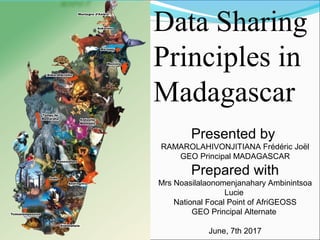
- 1. Data Sharing Principles in Madagascar Presented by RAMAROLAHIVONJITIANA Frédéric Joël GEO Principal MADAGASCAR Prepared with Mrs Noasilalaonomenjanahary Ambinintsoa Lucie National Focal Point of AfriGEOSS GEO Principal Alternate June, 7th 2017
- 2. 1. About Madagascar 2. Context of the GEOSS Data Sharing Principles 3. Commitment of the GEOSS Data Sharing Principles 4. Features and Implementation of the GEOSS Data Sharing in Madagascar PLAN OF PRESENTATION
- 4. Area: 590.000 square kilometers Population (2011) : 20 696 070. 5 times in comparaison of 1950. Localisation : The big island is located between 43° and 51° longitude -East, and 12° and 26° latitude - South. Langage: Malagasy Paradis of naturalistes: exceptional variety : biodiversity, tropical forest , mangroves, tsingy and so on… Diversities of cultures such as: mangoes, litchis, vanilla, apple, pear, bananas, pine apple, peach, advocats…)
- 5. MADAGASCAR ENDEMISM AND THREATS TO BIODIVERSITY Geographically and biologically isolated for millions of years, Madagascar is home to a vastarray of plants and animals found nowhere else in the world, including an estimated 101 endemic mammals, 202 endemic amphibians, 130 endemic birds, 370 endemic reptiles. If we refer of the result of searcher realized by WWF in Madagascar, 615 new animal and vegetal species is found and recensed in 10 years ago such as: 42 invertebrated, 17 fishes, 69 amphibians, 61 reptiles and 41 mammals,
- 6. Samples of species endemic - mammals »
- 7. Comète or butterfly –moon (papillon-lune) (Argema mitrei), endemic species in the humide drills of Madagascar Photo : Hery A. Rakotondravony.
- 9. The marvelous natural resources in Madagascar »
- 10. Species endemic plants Trees and bushes: 95,5% endemic Ptéridophyte: 50% endemic Palm: 100% endemic Orchids: 95% During 2008-2010, the number of the vascular endemic plants submitted in UICN is: 1676
- 11. SAMPLES OF THE SPECIES ENDEMIC PLANTS
- 12. EMERAUDE SEA
- 13. TSINGY
- 14. II.CONTEXT OF THE GEOSS DATA PRINCIPLES
- 15. Difficulties at a glance Data collection Human ressources Compartmentalization of data Capacity building infrastructure funding
- 16. IN GE SINCE 17 NOV 2009 Madagascar was in GEO- Data Sharing Working Group since 2012
- 17. Presentation of the implementation of the GEOSS Data Sharing in Madagascar in the GEO Ministerial Summit in Geneva-January 2014 with the Prime Minister
- 19. III. COMMITMENT OF GEOSS DATA SHARING
- 21. In the Madagascar Portal: The data from the forestry administration informing the exploitation authorization issued per Region (Forest) The data showing the quantity of woods exploited per Region The data showing cultivated area in comparaison of the extent of the Region (Min Agriculture), The data showing annual trend of the quantity of exploited woods (Forest) Categorization of the mining exploitation The data showing the trend on active fire detected per Region Climate zone distribution of Madagascar (Meteorogical) Data showing trend on burned area Data showing reforested area over the Region Spatial localisation at the zones adopting improved cultivation technique Data showing the extent of the protected area over Madagascar Delimitation of the zones managed by the Community
- 22. Data and Information Systems and Spatial Data Infrastructure
- 24. 3. Monitoring OF FISHING 2011:The GEO AMESD-IOC -: set 2 satelite antenna with 3 x 2 computors in the Ministry of fisheries in the center and in the High Marine Institut in the South West of Madagascar (Toliara).
- 25. PROJECT SEAS-OI The project SEAS-OI – (Surveillance Environnementale Appliquée à la Satelite) monitor the quality of the sea and the potential zone of fishing. The Satelite Station is based in Reunion- France
- 27. SATELITE STATION BASED IN REUNION – FRANCE Madagascar was in GEO- Data Sharing Working Group since 2012
- 29. ROLE OF THIS ANTENNA Monitoring of the temperature of the sea surface Monitoring of the level of the sea Monitoring of the Fishery boat in the Indian Ocean Monitoring of the concentration of the chlorophylle, the highspeed of the wind Identify the potential fishery zone
- 30. INAUGURATION OF THE SATELITE ANTENNE IN MADAGASCAR In the area of the Ministry in charge of fisheries in Madagascar on 2009,
- 31. 2. BIODIVERSITY Using the remote sensing for the best conservation of the biodiversity. Madagascar – Biodiversities hotspots
- 32. Zone OF Study of the World Conservation Society – Masoala and Makira
- 33. Terrestrials of the habitats in Makira and Masoala Images LANDSAT- Résolution middle
- 34. Marine Habitats- Masoala and Mananara North Images QUICKBIRD Very high Résolution
- 35. http://www.madagascar-baieantongil.org/ Differents types of reef habitat
- 36. Modèle of the distribution of the species Occurrence data Terrestrial HabitatsClimat Variable
- 37. D. C. Lees Habitat propice for the species Modèle of the distribution of the species
- 40. Climate Change Projection of the distribution of the species for 2050
- 41. Changement Climatique 23 species are analyzed : - 08 birds - 04 mammifères - 11 plantes
- 42. Perspectives Appui MRV Biodiversité – REDD + Combinaison télédétection « classique » et « Drones » -> Suivi
- 43. BIODIVERSITY OF MADAGASCAR IN THE WORLD NETWORK
- 44. 3. DISASTER
- 45. Madagascar has a National Office of Management of Risks and Disaster Le Bureau National de Gestion des Risques et Catastrophes (BNGRC) The BNGRC has prepared now how to face the future Cyclone in the next year. Madagascar has his plan of contingency The representant of ESA is visiting our office in april 2012.
- 46. SEISME in 16 mars 2012 at 14h56mn 59s, between Amparafaravola and Ambatondrazaka: Lat: 17.73 S, Long: 48.32 E, Magnitude 4.67, duration: 10sec in 02 january 2017, 1578,8 km of Toliara (South West) In 11 January 2017 at 01h06mn long 46,6332 et la lat-20,1581. 52,85 km de Antsirabe, Magnitude 5,5
- 50. MESA PROJECT
- 51. ILLEGAL BOAT IN THE IOC Centre Régional de Fusion d'Informations Maritimes (CRFIM)
- 52. GLOBAL CHANGES OF MADAGASCAR THROUGH SATELITE DATA DURING 40 YEARS
- 53. MIKEA FOREST 15 JUNE 1973 GREEN PART
- 54. MIKE FOREST 16 MARS 2003
- 55. 2. DEFORESTATION IN ITAMPOLO A- 2005A- 1975 B- 1975 B- 2005 D- 2005C- 2005D- 1975C- 1975
- 56. 3. DEFORESTATION IN ALAOTRA MANGORO REGION ALAOTRA-MANGORO Superficie de la Région 2 741 279ha Couverture Forestière En 1990 : 560 980ha, 20,46% En 2000 : 502 630ha, 18,33% En 2005 : 468 754ha, 17,09% Déforestation Perdue 90-00 : 58 350ha = 10,41% Perdue 00-05 : 33 876 ha = 06,74 %
- 57. 4. DEFORESTATION AROUND THE LAKE ALAOTRA
- 58. 5. RIVER DE MORONDAVA
- 60. 6. ELEVATION OF THE SEA IN THE WEST OF MADAGASCAR
- 61. IN Matsoarivo
- 63. PROJET MADEOS MADagascar Earth Observations Systems
- 64. IV. FEATURES AND IMPLEMENTATION OF THE GEOSS DATA SHARING IN MADAGASCAR
- 66. The 4 components of MADEOS are: • Component I: Elaboration and implementation of the National Strategy of the Environmental and Spatial Information. • Component II: Installation of the Infrastructure of the MADEOS – Madagascar Earth Observations Systems •Component III: Collect of the Environmental Informations from the local to the national level. •Component IV: Développement of the Application Open Source - GEstion Nationale de l’Information Environnementale et Spatiales – GENIES
- 67. Date to remember 04-08 september 2017 - MADAGASCAR International Workshop on Open Data for Sustainable Development Goals in Developing Countries
- 68. THANK YOU
- 69. CONTACT RAMAROLAHIVONJITIANA Frédéric Joël vonjilahitiana@yahoo.fr +261340562075 GEO Principal MADAGASCAR Director of Information System - Ministry of Environment, Ecology and Forest Antananarivo 101 Madagascar
Notas del editor
- Some of you know Noasy. I would like to apologize for her. She could not come because of her obligations. I’ll present the data sharing principles in Madagascar. By the way, I'll talk about our country. You can see left on the map of Madagascar some flora and fauna endemic to the country.
- Global Earth Observation System of Systems (GEOSS) : The GEOSS Common Infrastructure.
- Population More than 20,000,000
- Lemurs
- Island
- Orchids
- Madagascar commitment in sharing Data
- Regional centre of maritime information fusion Monitoring trafic
- Call for Technical and financial partner
- I would like to thank the ASSAF for their contribution CODATA for their support