SlideShare una empresa de Scribd logo
1 de 12
Descargar para leer sin conexión
UNIT 1: MAPS
1.- Fill the gaps with a suitable word from the box. You only need 14 words:
SPHERICAL
NORTH USE
PARALLELS GEOID
GLOBES
MAPS
DETAILED
SPHERE MERIDIANS FLATTENED

COMPASS
EQUATOR
REGIONAL

THREE-DIMENSIONAL DISTANCES
GLOBES
TWO-DIMENSIONAL
SUN DETAILED

Globes and maps
The Earth is _________________. However, it is not a perfect ____________. It is slightly ___________ at the
poles. This shape is called a ____________.
 ___________ represent the Earth accurately, because they have a similar shape: they are
__________________. However, they do not usually contain ___________ information.
 ___________ are the most common representations of the Earth. Maps are easy to _________and carry
around. They provide __________ and practical information at a local, __________ or international level.
However, maps are not as accurate as _____________, because they are _______________. Consequently,
shapes and _______________ are distorted.
2.- Answer the following questions about Establishing direction:



What do we use the cardinal points for?



What are the principal cardinal points?



Explain how the Sun can help us to establish direction.



What element in the sky always indicates the north?



What instrument with a magnetic needle always points north?

3.-Answer the following questions and label the maps:


What kind of maps give information on relief?



What kind of maps give information on particular subjects, such as climate or vegetation?



What kind of maps give information on political organisation?

___________________ ___________________

___________________
2.- Match each word to its definition:
Arrow

indicates how many times the area represented has been
reduced.

Title

contains the symbols which represent information on the map.

Parallels and
meridians

names of places or other information on the map.

Key

are imaginary lines which establish the exact location of places.

Text

shows what the map is about, the area which is represented, the
subjetc, etc.

Scale

pointing north enables us to establish orientation.

3.- Find the suitable word for the following definitions:(2 points)


Semicircles which go from one pole to another.__________________



An important parallel located south of the Tropic of Capricorn. .__________________



The point of reference for other meridians. .__________________



An important parallel located north of the Equator. .__________________



Circles which are perpendicular to the meridians. .__________________



The point of reference for other parallels. .__________________



An important parallel located south of the Equator. .__________________



Hemisphere which is located north of the Equator. .__________________



An important parallel located north of the Tropic of Cancer. .__________________



Hemisphere which is located south of the Equator. .__________________



4.- Fill the following boxes with a correct concept.
5.-Fill the gaps with a suitable word from the box. You only need 10 words:
MERIDIANS
COMPASS
POLES
LOCATED
(GEOGRAPHICAL COORDINATES)

LATITUDE
GLOBES
VERTICALLY
MAPS
HEMISPHERE
EAST
GEOID
EQUATOR
LOCATIONS
LONGITUDE

Latitude and longitude
Latitude and longitude indicate __________________________: the exact location of a place on the Earth.
_________________ is measured by using the parallels which start at the _________________ (0º). At the
poles they are _________________. They are north (N) or south (S) depending on whether they are
_________________ in the northern or southern hemisphere. All _________________ on a line have the same
_________________.
_________________ is measured by using the _________________ which star at the prime meridian (0º). They
run _________________ from 0º to _________________ to the west (W), and 0º to 180º to the
_________________ (E). All locations on a _________________ have the same _________________.
The combination of latitude and longitude gives us the _________________ of a place.

6.- Identify the coordinates. (1,1 points)
UNIT 2: RELIEF

1.- Label the parts of the Earth.

2.- Classify these words.

Mountains

Ocean trenches
Continental shelves

Continental relief

Cape
gulf

Island
Continental slopes
isthmus
Ocean ridges

Coastal

Plains Basins
Plateaus

Oceanic relief

3.- Name the parts of the course of a river and say in which part there is erosion, transport and sedimentation.
4.- Answer the following questions about the causes of erosion:
●

What are the most important agents of erosion?

●

What is the consecuence of abrupt changes in temperature?

●

Where is there a great difference between daytime and nighttime temperatures?

●

How can water break rocks?

5.- Fill the gaps about the erosion produced by water. Use the words on the box. There are 5 words that you don´t
have to use.
WATER WIND

CAVES

LIMESTONE
DEPOSITS

STEEP
SAND
CANYONS TRANSPORTS

VALLEYS

ERODED
FARMING

ERODE

CURRENTS
GENTLER
BEACHES

MARINE
SEDIMENT

SOLUTION
DISSOLVES
FLUVIAL
FLATTER

SOIL

WAVES
LANDSCAPES

________1______ acts constantly on the land:
● ________2______: water ____3__________ some rocks, such as _______4_______, producing unusual
_____5_________ and landscapes.
● ________6______ erosion::
○ Rivers travel fast down ________7______ slopes. They _________8_____ materials, and create deep
____9__________ and ________10______.
○ When the slopes are _____11_________, the water moves more slowly. It transports the
________12______ materials.
○ When rivers arrive at the ____13__________ lands which are near the sea, they deposit
________14______ on their banks. These areas are known as alluvial plains.
● _______15_______ erosion:
○ ________16______ and ____17__________ wear away coasts and create cliffs. Subsequently, the
water _____18________ the sediment and _______19_______ it. This process forms
________20______.
1
2
3
4

5
6
7
8

9
10
11
12

13
14
15
16

6.- Label the pictures with a suitable type of erosion. (0.4 points)

17
18
19
20
7.-Answer the following questions:


What theory developed the German scientist Alfred Wegener?



What is this theory about?



What is the name of the only continent that existed 225 million years ago?




What continents where there 135 million years ago?

8.- Match the sentences and write the whole sentences:

1

1 The tectonic plates

A often undulates where plates collide.

2

2 The tectonic plates

B is still rising.

3 Some plate move apart

C are in continuous movement.

4 The Earth´s surface

D blocks rise or sink.

4

5 The Earth´s crust sometimes fractures

E while others collide.

5

6 Where faults are created

F if the surface where plates collide is very extremely rigid.

7 The Himalaya mountain range in Asia

G move slowly at a speed of two to ten centimetres per year.

3

6
7

9.- Answer the following questions:


What happens when a volcano erupts?



How are islands, such as the Canary Islands, formed?



Where are volcanoes generally found?


What elements are found in the same areas as volcanoes?



How are earthquakes caused?

10.- Label the parts of a volcano. (0,4 points)

11.- Give a definition for the following terms:



Volcano



Earthquakes



Tsunamis

12.- Locate the following landforms on the physical world map.

1.- Rocky mountains

6.- Appalachian mountains

2.- Ural mountains

7.- Balkans

3.- Atlas mountains

8.- Tibetan Plateau

4.- Andes mountains

9.- Himalayas

5.- Great Dividing range

10.- Drakensberg mountains
UNIT 3: WATER

1. Put the stages in the water cycle in the correct order:
a. Groundwater goes into the sea.________
b. River water goes into the sea and other rivers. ________
c. Water from the sea evaporates. ________
d. Condensed vapour falls as precipitation. ________
e. Water vapour rises, cools and condenses. Clouds form. ________
f. Wind moves the clouds. ________
g. Some water infiltrates into the ground.
2.- Answer the following questions:


What are rivers?


Define "tributary"



Define "basin"



Define "flow"

3.- True or false. If they are wrong, correct them.
a. Oceans provide us with food.
b. Raw materials and energy are provided by the oceans.
c. Large quantities of gas and petroleum are found in the continental shelves.
d. Salt is obtained from rivers.
e. Oceans attract tourism to the coasts.
f.

Tourism does not create jobs in coastal areas.

g. Oceans are used for transport.
h. Oceans transport just people.

4.- Read the definitions and decide what they refer to :
a. It refers to the quantity of salt.____________
b. They are large masses of water, similar to rivers, which can be warm or cold. ____________
c. They are caused by the gravitational forces of the Moon and Sun acting on the water. ____________
d. Wind produces these undulations on the surface of the water. ____________
e. This product comes from the sea and is used for cooking. ____________

5.- Answer the following questions about lakes:
●

Define Lakes

●

Define Lagoons

●

Define inland seas

●

Make a diagram of the origin of the water in lakes.
6.- Answer the following questions about groundwater
1. Where does groundwater run and where is it stored?

2. Where does most of the water come from?

3. When it rains, what happens with some of the water?

4. What happens when this water reaches impermeable rocks?

5. Define "aquifer"

6. What does groundwater form when it finds a way to the surface?

7. Make a diagram of the value of groundwater.

7.- Answer the following questions about glaciers and icebergs:


What kind of water is there in a glacier?



Define "glacier"



Where are glaciers found?



What happens when a glacier reaches the sea?



Define "iceberg"
8.- Find the correct term for the following definitions:
●

A shortage of water can produce this:_____________

●

An excess of water can produce this::_____________

●

It occurs when large amounts of materials are added to a body of water.:_____________

●

It contains harmful chemicals such as sulphur and nitrogen.:_____________

9.- Complete the gaps using a word from the box. (1 point)

Chemicals (water cycle) rainfall gases (Acid rain) transformationclouds

___________ contains harmful chemicals such as sulphur and nitrogen. These ____________ are released
into the atmosphere as _________. They undergo a chemical _______________and are absorbed by the
water in ____________. They become part of ___________ and enter in the _____________________.
10.- Label the following pictures related to water.
Trabajo recuperacion 1evaluacion 1bilingual

Más contenido relacionado

La actualidad más candente (10)

Solar: seasons and review
Solar:  seasons and reviewSolar:  seasons and review
Solar: seasons and review
 
Solar: about the sun (worksheet 5)
Solar: about the sun (worksheet 5)Solar: about the sun (worksheet 5)
Solar: about the sun (worksheet 5)
 
Order of Planets (Worksheet answers )
Order of Planets   (Worksheet answers )Order of Planets   (Worksheet answers )
Order of Planets (Worksheet answers )
 
Order of the planets (worksheet)
Order of the planets  (worksheet)Order of the planets  (worksheet)
Order of the planets (worksheet)
 
Solar:planet rotate orbit (worksheet 2)
Solar:planet rotate orbit (worksheet 2)Solar:planet rotate orbit (worksheet 2)
Solar:planet rotate orbit (worksheet 2)
 
Examen the earth 2014 answer
Examen the earth 2014 answerExamen the earth 2014 answer
Examen the earth 2014 answer
 
E learning class final
E learning class finalE learning class final
E learning class final
 
Unit 5 lesson 1
Unit 5 lesson 1Unit 5 lesson 1
Unit 5 lesson 1
 
What do you know about the moon
What do you know about the moonWhat do you know about the moon
What do you know about the moon
 
Worksheet 06 the earth
Worksheet 06 the earthWorksheet 06 the earth
Worksheet 06 the earth
 

Destacado (9)

Population migration
Population migrationPopulation migration
Population migration
 
Pharaohs of Egypt
Pharaohs of EgyptPharaohs of Egypt
Pharaohs of Egypt
 
Examen ejemplo de lengua castellana y literatura 1º eso
Examen ejemplo de lengua castellana y literatura 1º esoExamen ejemplo de lengua castellana y literatura 1º eso
Examen ejemplo de lengua castellana y literatura 1º eso
 
La Tierra
La TierraLa Tierra
La Tierra
 
Tema 1. La Tierra. 1º ESO
Tema 1. La Tierra. 1º ESOTema 1. La Tierra. 1º ESO
Tema 1. La Tierra. 1º ESO
 
Ciencias naturales refuerzo 1º eso
Ciencias naturales refuerzo 1º esoCiencias naturales refuerzo 1º eso
Ciencias naturales refuerzo 1º eso
 
Revolution of the earth
Revolution of the earthRevolution of the earth
Revolution of the earth
 
Grid_scale
Grid_scaleGrid_scale
Grid_scale
 
Time zones
Time zonesTime zones
Time zones
 

Similar a Trabajo recuperacion 1evaluacion 1bilingual

Social studies geography study guide
Social studies geography study guideSocial studies geography study guide
Social studies geography study guide
shannonbandy
 
Mountains%2c earthquakes%2c volcanoes notes
Mountains%2c earthquakes%2c volcanoes notesMountains%2c earthquakes%2c volcanoes notes
Mountains%2c earthquakes%2c volcanoes notes
harvey09
 
UNIT 02.-A SPACECRAFT CALLED EARTH (Worksheet)
UNIT 02.-A SPACECRAFT CALLED EARTH (Worksheet)UNIT 02.-A SPACECRAFT CALLED EARTH (Worksheet)
UNIT 02.-A SPACECRAFT CALLED EARTH (Worksheet)
Toribio Florez Lopez
 
Chapter 9outline
Chapter 9outlineChapter 9outline
Chapter 9outline
jmchenry071
 
Ch. 3 section 2 worksheet
Ch. 3 section 2 worksheetCh. 3 section 2 worksheet
Ch. 3 section 2 worksheet
John Hext
 

Similar a Trabajo recuperacion 1evaluacion 1bilingual (20)

Trabajo recuperacion 1evaluacion 1bilingual (2)
Trabajo recuperacion 1evaluacion 1bilingual (2)Trabajo recuperacion 1evaluacion 1bilingual (2)
Trabajo recuperacion 1evaluacion 1bilingual (2)
 
Recuperacion 2 ev_1bil (2)
Recuperacion 2 ev_1bil (2)Recuperacion 2 ev_1bil (2)
Recuperacion 2 ev_1bil (2)
 
L6 continents and ocean
L6 continents and oceanL6 continents and ocean
L6 continents and ocean
 
Contours
ContoursContours
Contours
 
Working with Contour Maps
Working with Contour MapsWorking with Contour Maps
Working with Contour Maps
 
4th periodical science v
4th periodical science v4th periodical science v
4th periodical science v
 
Activities Water
Activities WaterActivities Water
Activities Water
 
Unit 2
Unit 2Unit 2
Unit 2
 
Social studies geography study guide
Social studies geography study guideSocial studies geography study guide
Social studies geography study guide
 
Dynamic Earth Note Packet
Dynamic Earth Note PacketDynamic Earth Note Packet
Dynamic Earth Note Packet
 
Mountains%2c earthquakes%2c volcanoes notes
Mountains%2c earthquakes%2c volcanoes notesMountains%2c earthquakes%2c volcanoes notes
Mountains%2c earthquakes%2c volcanoes notes
 
Unit 6 Earth's structure
Unit 6  Earth's structureUnit 6  Earth's structure
Unit 6 Earth's structure
 
Dynamic earth np1
Dynamic earth np1Dynamic earth np1
Dynamic earth np1
 
UNIT 02.-A SPACECRAFT CALLED EARTH (Worksheet)
UNIT 02.-A SPACECRAFT CALLED EARTH (Worksheet)UNIT 02.-A SPACECRAFT CALLED EARTH (Worksheet)
UNIT 02.-A SPACECRAFT CALLED EARTH (Worksheet)
 
Astronomy fourth grade
Astronomy fourth gradeAstronomy fourth grade
Astronomy fourth grade
 
ELS MODULE 1 PPT.pptx
ELS MODULE 1 PPT.pptxELS MODULE 1 PPT.pptx
ELS MODULE 1 PPT.pptx
 
Chapter 9outline
Chapter 9outlineChapter 9outline
Chapter 9outline
 
first quarterly assessment in science,tle,science 8 2023.docx
first quarterly assessment in science,tle,science 8 2023.docxfirst quarterly assessment in science,tle,science 8 2023.docx
first quarterly assessment in science,tle,science 8 2023.docx
 
Ch. 3 section 2 worksheet
Ch. 3 section 2 worksheetCh. 3 section 2 worksheet
Ch. 3 section 2 worksheet
 
Exercices retest 3rd_term (3)
Exercices retest 3rd_term (3)Exercices retest 3rd_term (3)
Exercices retest 3rd_term (3)
 

Más de Profesora Geografía e Historia IES

Más de Profesora Geografía e Historia IES (20)

El antiguo régimen y la Ilustración.pptx
El antiguo régimen y la Ilustración.pptxEl antiguo régimen y la Ilustración.pptx
El antiguo régimen y la Ilustración.pptx
 
Tourism
TourismTourism
Tourism
 
Industry
Industry Industry
Industry
 
Writing and Art in Mesopotamia
Writing and Art in MesopotamiaWriting and Art in Mesopotamia
Writing and Art in Mesopotamia
 
Primary sector farming
Primary sector farmingPrimary sector farming
Primary sector farming
 
Palaeolithic Age
Palaeolithic AgePalaeolithic Age
Palaeolithic Age
 
Neolithic Age
Neolithic AgeNeolithic Age
Neolithic Age
 
Metal ages
Metal agesMetal ages
Metal ages
 
Atlanta (USA)
Atlanta (USA)Atlanta (USA)
Atlanta (USA)
 
Urban layouts
Urban layoutsUrban layouts
Urban layouts
 
Settlement hierarchies
Settlement hierarchiesSettlement hierarchies
Settlement hierarchies
 
Rural settlements
Rural settlementsRural settlements
Rural settlements
 
Physical characteristics of the continents
Physical characteristics of the continentsPhysical characteristics of the continents
Physical characteristics of the continents
 
The Catholic Monarchs and the Habsbourg in Spain
The Catholic Monarchs and the Habsbourg in SpainThe Catholic Monarchs and the Habsbourg in Spain
The Catholic Monarchs and the Habsbourg in Spain
 
Wwi
WwiWwi
Wwi
 
Industrial Revolution
Industrial RevolutionIndustrial Revolution
Industrial Revolution
 
Project Romanesque art
Project Romanesque artProject Romanesque art
Project Romanesque art
 
Islam
IslamIslam
Islam
 
Al-andalus
Al-andalusAl-andalus
Al-andalus
 
The shaping of landforms
The shaping of landformsThe shaping of landforms
The shaping of landforms
 

Último

Why Teams call analytics are critical to your entire business
Why Teams call analytics are critical to your entire businessWhy Teams call analytics are critical to your entire business
Why Teams call analytics are critical to your entire business
panagenda
 
+971581248768>> SAFE AND ORIGINAL ABORTION PILLS FOR SALE IN DUBAI AND ABUDHA...
+971581248768>> SAFE AND ORIGINAL ABORTION PILLS FOR SALE IN DUBAI AND ABUDHA...+971581248768>> SAFE AND ORIGINAL ABORTION PILLS FOR SALE IN DUBAI AND ABUDHA...
+971581248768>> SAFE AND ORIGINAL ABORTION PILLS FOR SALE IN DUBAI AND ABUDHA...
?#DUbAI#??##{{(☎️+971_581248768%)**%*]'#abortion pills for sale in dubai@
 
Cloud Frontiers: A Deep Dive into Serverless Spatial Data and FME
Cloud Frontiers:  A Deep Dive into Serverless Spatial Data and FMECloud Frontiers:  A Deep Dive into Serverless Spatial Data and FME
Cloud Frontiers: A Deep Dive into Serverless Spatial Data and FME
Safe Software
 

Último (20)

Why Teams call analytics are critical to your entire business
Why Teams call analytics are critical to your entire businessWhy Teams call analytics are critical to your entire business
Why Teams call analytics are critical to your entire business
 
presentation ICT roal in 21st century education
presentation ICT roal in 21st century educationpresentation ICT roal in 21st century education
presentation ICT roal in 21st century education
 
Vector Search -An Introduction in Oracle Database 23ai.pptx
Vector Search -An Introduction in Oracle Database 23ai.pptxVector Search -An Introduction in Oracle Database 23ai.pptx
Vector Search -An Introduction in Oracle Database 23ai.pptx
 
Strategize a Smooth Tenant-to-tenant Migration and Copilot Takeoff
Strategize a Smooth Tenant-to-tenant Migration and Copilot TakeoffStrategize a Smooth Tenant-to-tenant Migration and Copilot Takeoff
Strategize a Smooth Tenant-to-tenant Migration and Copilot Takeoff
 
Mcleodganj Call Girls 🥰 8617370543 Service Offer VIP Hot Model
Mcleodganj Call Girls 🥰 8617370543 Service Offer VIP Hot ModelMcleodganj Call Girls 🥰 8617370543 Service Offer VIP Hot Model
Mcleodganj Call Girls 🥰 8617370543 Service Offer VIP Hot Model
 
EMPOWERMENT TECHNOLOGY GRADE 11 QUARTER 2 REVIEWER
EMPOWERMENT TECHNOLOGY GRADE 11 QUARTER 2 REVIEWEREMPOWERMENT TECHNOLOGY GRADE 11 QUARTER 2 REVIEWER
EMPOWERMENT TECHNOLOGY GRADE 11 QUARTER 2 REVIEWER
 
FWD Group - Insurer Innovation Award 2024
FWD Group - Insurer Innovation Award 2024FWD Group - Insurer Innovation Award 2024
FWD Group - Insurer Innovation Award 2024
 
Biography Of Angeliki Cooney | Senior Vice President Life Sciences | Albany, ...
Biography Of Angeliki Cooney | Senior Vice President Life Sciences | Albany, ...Biography Of Angeliki Cooney | Senior Vice President Life Sciences | Albany, ...
Biography Of Angeliki Cooney | Senior Vice President Life Sciences | Albany, ...
 
ProductAnonymous-April2024-WinProductDiscovery-MelissaKlemke
ProductAnonymous-April2024-WinProductDiscovery-MelissaKlemkeProductAnonymous-April2024-WinProductDiscovery-MelissaKlemke
ProductAnonymous-April2024-WinProductDiscovery-MelissaKlemke
 
Rising Above_ Dubai Floods and the Fortitude of Dubai International Airport.pdf
Rising Above_ Dubai Floods and the Fortitude of Dubai International Airport.pdfRising Above_ Dubai Floods and the Fortitude of Dubai International Airport.pdf
Rising Above_ Dubai Floods and the Fortitude of Dubai International Airport.pdf
 
CNIC Information System with Pakdata Cf In Pakistan
CNIC Information System with Pakdata Cf In PakistanCNIC Information System with Pakdata Cf In Pakistan
CNIC Information System with Pakdata Cf In Pakistan
 
Platformless Horizons for Digital Adaptability
Platformless Horizons for Digital AdaptabilityPlatformless Horizons for Digital Adaptability
Platformless Horizons for Digital Adaptability
 
Corporate and higher education May webinar.pptx
Corporate and higher education May webinar.pptxCorporate and higher education May webinar.pptx
Corporate and higher education May webinar.pptx
 
AWS Community Day CPH - Three problems of Terraform
AWS Community Day CPH - Three problems of TerraformAWS Community Day CPH - Three problems of Terraform
AWS Community Day CPH - Three problems of Terraform
 
+971581248768>> SAFE AND ORIGINAL ABORTION PILLS FOR SALE IN DUBAI AND ABUDHA...
+971581248768>> SAFE AND ORIGINAL ABORTION PILLS FOR SALE IN DUBAI AND ABUDHA...+971581248768>> SAFE AND ORIGINAL ABORTION PILLS FOR SALE IN DUBAI AND ABUDHA...
+971581248768>> SAFE AND ORIGINAL ABORTION PILLS FOR SALE IN DUBAI AND ABUDHA...
 
Strategies for Landing an Oracle DBA Job as a Fresher
Strategies for Landing an Oracle DBA Job as a FresherStrategies for Landing an Oracle DBA Job as a Fresher
Strategies for Landing an Oracle DBA Job as a Fresher
 
Elevate Developer Efficiency & build GenAI Application with Amazon Q​
Elevate Developer Efficiency & build GenAI Application with Amazon Q​Elevate Developer Efficiency & build GenAI Application with Amazon Q​
Elevate Developer Efficiency & build GenAI Application with Amazon Q​
 
Apidays New York 2024 - APIs in 2030: The Risk of Technological Sleepwalk by ...
Apidays New York 2024 - APIs in 2030: The Risk of Technological Sleepwalk by ...Apidays New York 2024 - APIs in 2030: The Risk of Technological Sleepwalk by ...
Apidays New York 2024 - APIs in 2030: The Risk of Technological Sleepwalk by ...
 
Cloud Frontiers: A Deep Dive into Serverless Spatial Data and FME
Cloud Frontiers:  A Deep Dive into Serverless Spatial Data and FMECloud Frontiers:  A Deep Dive into Serverless Spatial Data and FME
Cloud Frontiers: A Deep Dive into Serverless Spatial Data and FME
 
Repurposing LNG terminals for Hydrogen Ammonia: Feasibility and Cost Saving
Repurposing LNG terminals for Hydrogen Ammonia: Feasibility and Cost SavingRepurposing LNG terminals for Hydrogen Ammonia: Feasibility and Cost Saving
Repurposing LNG terminals for Hydrogen Ammonia: Feasibility and Cost Saving
 

Trabajo recuperacion 1evaluacion 1bilingual

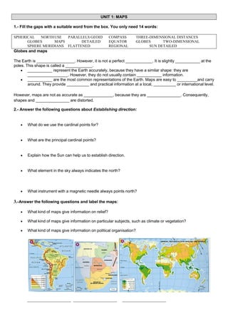
  • 1. UNIT 1: MAPS 1.- Fill the gaps with a suitable word from the box. You only need 14 words: SPHERICAL NORTH USE PARALLELS GEOID GLOBES MAPS DETAILED SPHERE MERIDIANS FLATTENED COMPASS EQUATOR REGIONAL THREE-DIMENSIONAL DISTANCES GLOBES TWO-DIMENSIONAL SUN DETAILED Globes and maps The Earth is _________________. However, it is not a perfect ____________. It is slightly ___________ at the poles. This shape is called a ____________.  ___________ represent the Earth accurately, because they have a similar shape: they are __________________. However, they do not usually contain ___________ information.  ___________ are the most common representations of the Earth. Maps are easy to _________and carry around. They provide __________ and practical information at a local, __________ or international level. However, maps are not as accurate as _____________, because they are _______________. Consequently, shapes and _______________ are distorted. 2.- Answer the following questions about Establishing direction:  What do we use the cardinal points for?  What are the principal cardinal points?  Explain how the Sun can help us to establish direction.  What element in the sky always indicates the north?  What instrument with a magnetic needle always points north? 3.-Answer the following questions and label the maps:  What kind of maps give information on relief?  What kind of maps give information on particular subjects, such as climate or vegetation?  What kind of maps give information on political organisation? ___________________ ___________________ ___________________
  • 2. 2.- Match each word to its definition: Arrow indicates how many times the area represented has been reduced. Title contains the symbols which represent information on the map. Parallels and meridians names of places or other information on the map. Key are imaginary lines which establish the exact location of places. Text shows what the map is about, the area which is represented, the subjetc, etc. Scale pointing north enables us to establish orientation. 3.- Find the suitable word for the following definitions:(2 points)  Semicircles which go from one pole to another.__________________  An important parallel located south of the Tropic of Capricorn. .__________________  The point of reference for other meridians. .__________________  An important parallel located north of the Equator. .__________________  Circles which are perpendicular to the meridians. .__________________  The point of reference for other parallels. .__________________  An important parallel located south of the Equator. .__________________  Hemisphere which is located north of the Equator. .__________________  An important parallel located north of the Tropic of Cancer. .__________________  Hemisphere which is located south of the Equator. .__________________  4.- Fill the following boxes with a correct concept.
  • 3. 5.-Fill the gaps with a suitable word from the box. You only need 10 words: MERIDIANS COMPASS POLES LOCATED (GEOGRAPHICAL COORDINATES) LATITUDE GLOBES VERTICALLY MAPS HEMISPHERE EAST GEOID EQUATOR LOCATIONS LONGITUDE Latitude and longitude Latitude and longitude indicate __________________________: the exact location of a place on the Earth. _________________ is measured by using the parallels which start at the _________________ (0º). At the poles they are _________________. They are north (N) or south (S) depending on whether they are _________________ in the northern or southern hemisphere. All _________________ on a line have the same _________________. _________________ is measured by using the _________________ which star at the prime meridian (0º). They run _________________ from 0º to _________________ to the west (W), and 0º to 180º to the _________________ (E). All locations on a _________________ have the same _________________. The combination of latitude and longitude gives us the _________________ of a place. 6.- Identify the coordinates. (1,1 points)
  • 4. UNIT 2: RELIEF 1.- Label the parts of the Earth. 2.- Classify these words. Mountains Ocean trenches Continental shelves Continental relief Cape gulf Island Continental slopes isthmus Ocean ridges Coastal Plains Basins Plateaus Oceanic relief 3.- Name the parts of the course of a river and say in which part there is erosion, transport and sedimentation.
  • 5. 4.- Answer the following questions about the causes of erosion: ● What are the most important agents of erosion? ● What is the consecuence of abrupt changes in temperature? ● Where is there a great difference between daytime and nighttime temperatures? ● How can water break rocks? 5.- Fill the gaps about the erosion produced by water. Use the words on the box. There are 5 words that you don´t have to use. WATER WIND CAVES LIMESTONE DEPOSITS STEEP SAND CANYONS TRANSPORTS VALLEYS ERODED FARMING ERODE CURRENTS GENTLER BEACHES MARINE SEDIMENT SOLUTION DISSOLVES FLUVIAL FLATTER SOIL WAVES LANDSCAPES ________1______ acts constantly on the land: ● ________2______: water ____3__________ some rocks, such as _______4_______, producing unusual _____5_________ and landscapes. ● ________6______ erosion:: ○ Rivers travel fast down ________7______ slopes. They _________8_____ materials, and create deep ____9__________ and ________10______. ○ When the slopes are _____11_________, the water moves more slowly. It transports the ________12______ materials. ○ When rivers arrive at the ____13__________ lands which are near the sea, they deposit ________14______ on their banks. These areas are known as alluvial plains. ● _______15_______ erosion: ○ ________16______ and ____17__________ wear away coasts and create cliffs. Subsequently, the water _____18________ the sediment and _______19_______ it. This process forms ________20______. 1 2 3 4 5 6 7 8 9 10 11 12 13 14 15 16 6.- Label the pictures with a suitable type of erosion. (0.4 points) 17 18 19 20
  • 6. 7.-Answer the following questions:  What theory developed the German scientist Alfred Wegener?  What is this theory about?  What is the name of the only continent that existed 225 million years ago?   What continents where there 135 million years ago? 8.- Match the sentences and write the whole sentences: 1 1 The tectonic plates A often undulates where plates collide. 2 2 The tectonic plates B is still rising. 3 Some plate move apart C are in continuous movement. 4 The Earth´s surface D blocks rise or sink. 4 5 The Earth´s crust sometimes fractures E while others collide. 5 6 Where faults are created F if the surface where plates collide is very extremely rigid. 7 The Himalaya mountain range in Asia G move slowly at a speed of two to ten centimetres per year. 3 6 7 9.- Answer the following questions:  What happens when a volcano erupts?  How are islands, such as the Canary Islands, formed?  Where are volcanoes generally found?
  • 7.  What elements are found in the same areas as volcanoes?  How are earthquakes caused? 10.- Label the parts of a volcano. (0,4 points) 11.- Give a definition for the following terms:  Volcano  Earthquakes  Tsunamis 12.- Locate the following landforms on the physical world map. 1.- Rocky mountains 6.- Appalachian mountains 2.- Ural mountains 7.- Balkans 3.- Atlas mountains 8.- Tibetan Plateau 4.- Andes mountains 9.- Himalayas 5.- Great Dividing range 10.- Drakensberg mountains
  • 8. UNIT 3: WATER 1. Put the stages in the water cycle in the correct order: a. Groundwater goes into the sea.________ b. River water goes into the sea and other rivers. ________ c. Water from the sea evaporates. ________ d. Condensed vapour falls as precipitation. ________ e. Water vapour rises, cools and condenses. Clouds form. ________ f. Wind moves the clouds. ________ g. Some water infiltrates into the ground. 2.- Answer the following questions:  What are rivers?
  • 9.  Define "tributary"  Define "basin"  Define "flow" 3.- True or false. If they are wrong, correct them. a. Oceans provide us with food. b. Raw materials and energy are provided by the oceans. c. Large quantities of gas and petroleum are found in the continental shelves. d. Salt is obtained from rivers. e. Oceans attract tourism to the coasts. f. Tourism does not create jobs in coastal areas. g. Oceans are used for transport. h. Oceans transport just people. 4.- Read the definitions and decide what they refer to : a. It refers to the quantity of salt.____________ b. They are large masses of water, similar to rivers, which can be warm or cold. ____________ c. They are caused by the gravitational forces of the Moon and Sun acting on the water. ____________ d. Wind produces these undulations on the surface of the water. ____________ e. This product comes from the sea and is used for cooking. ____________ 5.- Answer the following questions about lakes: ● Define Lakes ● Define Lagoons ● Define inland seas ● Make a diagram of the origin of the water in lakes.
  • 10. 6.- Answer the following questions about groundwater 1. Where does groundwater run and where is it stored? 2. Where does most of the water come from? 3. When it rains, what happens with some of the water? 4. What happens when this water reaches impermeable rocks? 5. Define "aquifer" 6. What does groundwater form when it finds a way to the surface? 7. Make a diagram of the value of groundwater. 7.- Answer the following questions about glaciers and icebergs:  What kind of water is there in a glacier?  Define "glacier"  Where are glaciers found?  What happens when a glacier reaches the sea?  Define "iceberg"
  • 11. 8.- Find the correct term for the following definitions: ● A shortage of water can produce this:_____________ ● An excess of water can produce this::_____________ ● It occurs when large amounts of materials are added to a body of water.:_____________ ● It contains harmful chemicals such as sulphur and nitrogen.:_____________ 9.- Complete the gaps using a word from the box. (1 point) Chemicals (water cycle) rainfall gases (Acid rain) transformationclouds ___________ contains harmful chemicals such as sulphur and nitrogen. These ____________ are released into the atmosphere as _________. They undergo a chemical _______________and are absorbed by the water in ____________. They become part of ___________ and enter in the _____________________. 10.- Label the following pictures related to water.