SlideShare una empresa de Scribd logo
1 de 8
Descargar para leer sin conexión
Fundamentals of GIS Chap. 1 : Introduction of GIS
Prepared By: Ajay A. Ardeshana, Lecturer of MCA, GARDI VIDYAPITH, Rajkot.
Email: ajay.24021985@gmail.com Mobile: +91-95588 20298
Page : 1
Chapter : 1 : Introduction of GIS
 History of GIS :
 In 1960 the Department of Forestry and Rural Department of Canada has decided
to pursue a large-scale project to manage the resources.
 The initial task was the inventory and mapping of the available forest and mineral
resources wildlife requirements and water availability and quantity.
 The mission was just to gathering the amount of data, compilation, analysis,
evaluation and modeling. It becomes obvious that the map of resources permit
viewing the extents.
 The meeting between the Director of the Department of Forestry and Rural
Development and IBM executive has suggested an application of the newly
emerging computer technology to the problem was known as Canada
Geographical Information System (CGIS).
 Today it is an ever increasing requirement of the following companies……
 Fire departments
 The Military departments
 Cellular Phone Companies
 Real Estate Companies
 Police Departments
 Transportation Companies etc…..
 What is GIS?
 “GISs are the tools that allows for the processing of spatial data to make a
decision about some portion of the earth.”
 “GIS is a computer system for capturing, storing, querying, analyzing, evaluating
and displaying the geospatial data.”
Taxonomy of Information System
Fundamentals of GIS Chap. 1 : Introduction of GIS
Prepared By: Ajay A. Ardeshana, Lecturer of MCA, GARDI VIDYAPITH, Rajkot.
Email: ajay.24021985@gmail.com Mobile: +91-95588 20298
Page : 2
 Applications of GIS :-
 Business
1. Banking: - Financial analysts employ GIS for targeting their markets by
visualizing service needs. Companies including Metropolitan Life and Chase
Manhattan Bank rely on GIS software to help them improve operational
excellence and profitability.
2. Insurance: - Many insurance companies have made GIS a central component
of their business, using it to visualize, analyze, and distribute risk. Companies
such as CHUBB Insurance use GIS software for portfolio risk management.
3. Media: - GIS is used by media bureaus for everything from analyzing
circulation and attracting advertisers to creating the maps used in the
material itself. The Associated Press (AP), USA TODAY, and National
Geographic Society use GIS software to create accurate maps quickly for
magazines, newspapers, and online news services.
4. Real Estate: - From map-based contact management to sophisticated
investment analysis in large real estate investment trusts, real estate
agencies rely heavily on electronic mapping. Companies such as SSR Realty
Advisors, Inc. use GIS in commercial real estate, while REALTOR.com uses GIS
to bring maps online to 1.2 million people shopping for a new home.
5. Logistics: - Logistics management requires planning the distribution fleet's
activities, route locations, and schedules. Argentina's telephone company,
Grupo Telefónica, uses the GIS logistics routing solution shown to the right to
increase the number of daily deliveries without increasing resources.
6. Retail: - Businesses maintain information about sales, customers, inventory,
demographic profiles, and mailing lists, all of which have geographic
locations. Business managers, marketing strategists, financial analysts, and
professional planners increasingly rely on GIS to organize, analyze, and
present their business data.
 Government
1. National Government: - Government agencies trust GIS technology to
establish and regulate policy and to strengthen the welfare of their citizens.
GIS is also an intelligent means for agencies to provide public information.
The U.S. government relies heavily on GIS to evaluate the results of U.S.
Census 2000.
2. Local Government: - Revenue collection, economic development, and public
information are just a few opportunities that GIS affords municipalities. The
cities of Madrid, Geneva, and Paris all use GIS for providing many city
services.
Fundamentals of GIS Chap. 1 : Introduction of GIS
Prepared By: Ajay A. Ardeshana, Lecturer of MCA, GARDI VIDYAPITH, Rajkot.
Email: ajay.24021985@gmail.com Mobile: +91-95588 20298
Page : 3
3. Homeland Security: - GIS assets at local, regional, and national levels are
used in emergency response in the areas of detection, risk assessment,
mitigation and prevention, preparedness, response, and recovery. Utilized in
both natural and human-induced disasters, GIS has merged into the
common operating procedures for public safety and emergency response
activities. City, county, state, and federal-level agencies use GIS as a
common framework for organizing and sharing data in a digital world.
4. Military Defense: - Military defense uses GIS for intelligence, terrain
analysis, mission planning, and facilities management. Geographic analysis is
critical in military operations, tactical or logistical planning, and
infrastructure management.
5. Emergency Medical services: - GIS allows public safety personnel to
effectively plan for emergency response, determine mitigation priorities,
analyze historical events, and predict future events.
6. Transportation: - GIS serves three distinct transportation needs:
infrastructure management, fleet and logistics management, and transit
management. GIS offers insight for network planning and analysis, vehicle
tracking and routing, inventory tracking, and route planning analysis.
 Education and Science
1. Research: - GIS is an ideal tool to help researchers model the real world,
classify and observe phenomena, and predict changes over time. Ready-
made data models make it easy to work with layers of data to observe
relationships and explore new methods to represent the world around us.
2. Library and Museum: - GIS creates interactive maps for museum exhibits
that help visitors explore people, places, and events. GIS is also a valuable
research tool used by museum scientists and researchers to increase
people's understanding of natural systems and human cultures from
anthropology to zoology.
 Environment and Conservation
1. Water: - Environmental management and stewardship programs integrate a
broad spectrum of data with the analysis tools of GIS to provide a better
understanding of how elements of natural communities interact across a
landscape. GIS is used worldwide in ecology labs, planning departments,
parks, agencies, and nonprofit organizations to promote sustainable growth.
2. Ocean: - Marine GIS uses data from oceans and seas to represent near shore
and deepwater phenomena such as current, salinity, temperature, biological
and ecological mass, and density.
Fundamentals of GIS Chap. 1 : Introduction of GIS
Prepared By: Ajay A. Ardeshana, Lecturer of MCA, GARDI VIDYAPITH, Rajkot.
Email: ajay.24021985@gmail.com Mobile: +91-95588 20298
Page : 4
3. Land: - Accurate information about the local landscape is critical to making
decisions about what to protect and how to protect it. Digital maps of sites
can be linked to a relational database that stores topography, baseline data,
site documentation, and aerial digital photography.
4. Wildlife: - GIS is an important tool in habitat and species management and
protection. GIS enables the study of animal populations at a variety of scales
as well as analysis tools to study habitat corridors; migration patterns; and
the influence of parks, reserves, and sanctuaries for wildlife conservation.
5. Vegetation :- GIS is ideal for mapping and inventorying vegetation across
landscapes and to better understand threatened and endangered species
inventories for scientific and managerial applications
 Natural Resources
1. Agriculture :- GIS provides the analytical capabilities that form the hub of a
successful precision agriculture system. GIS lets farmers perform site-specific
spatial analyses of agronomic data.
2. Forestry :- Ireland's forestry service, Coillte Teoranta, uses GIS as a key
component in managing its timber resources and maintaining sustainable
forest management. Coillte Teoranta leverages GIS functionality for
applications as diverse as land valuation, timber market analysis, harvest
route planning, and landscape visualization.
3. Oil and Gas :- Where to drill, route a pipeline, or build a refinery are all
questions that rely heavily on an understanding of geography
 Components of GIS
Like any other Information Technology, GIS requires the following five components to
work with geospatial data.
1. Computer System :-
 Computer system includes the computer and Operating System to run the
GIS.
2. GIS Software :-
 GIS Software includes the program and the user interface for driving the
hardware. Common interfaces in GIS are Menus, Graphical Icons, Command
lines and Scripts.
 e.g. Arc Map, Arc Catalog, Arc GIS Server etc…
Fundamentals of GIS Chap. 1 : Introduction of GIS
Prepared By: Ajay A. Ardeshana, Lecturer of MCA, GARDI VIDYAPITH, Rajkot.
Email: ajay.24021985@gmail.com Mobile: +91-95588 20298
Page : 5
3. People :-
 Peoples refer to the GIS Professionals and users who define the purpose and
objectives and provide the reasons and justification for using GIS.
4. Data :-
 Data consists of the various kinds of inputs that system takes.
5. Infrastructure :-
 The infrastructure refers to the necessary physical, organizational,
administrative and cultural environment that supports GIS operations.
 What is Geospatial Data?
Geospatial Data are the data which describe the Location and Characteristics of
Spatial Features such as Roads, Vegetations Stands and Land Parcels on the Earth’s
Surface.
Geospatial Data separate GIS from other Information Systems. Therefore before
discussing the Operations of GIS we must understand the nature of Geospatial Data.
For Example to describe the road, we refer to its location (where it is) and it
characteristics (Length, Name, Speed Limit and Direction). The Location also called a
geometry or shape, represent Geospatial Data, where as the characteristics are
Attribute Data.
Basically any Geospatial Data has a two components like : Spatial Data Attribute Data
1. Spatial Data :-
 Spatial data describe the location of spatial features, which may be discrete or
continuous.
 Discrete Features are individually distinguishable features that do not exist
between observation. It includes Point, Line and Areas (Polygon).
 Continuous Features are features that exist spatially between observations.
Examples of continuous are elevation and precipitation.
 GIS represent these spatial features on the Earth’s surface as Map features on
a plane surface. This transformation involves two main issues:
1. Spatial reference system
2. Data model
 Location of the spatial features on the Earth’s surface are based on a
geographic coordinate system with latitude and longitude values, where as the
location of map features are based on the plain coordinate system with X, Y
coordinates.
Fundamentals of GIS Chap. 1 : Introduction of GIS
Prepared By: Ajay A. Ardeshana, Lecturer of MCA, GARDI VIDYAPITH, Rajkot.
Email: ajay.24021985@gmail.com Mobile: +91-95588 20298
Page : 6
 Projection is the process the can transform the Earth’s spherical surface to a
plane surface and bridge the two spatial reference system.
 The Data Model defines how spatial features are represented in a GIS.
 The Vector Data Model uses Points and their X and Y coordinates to constructs
spatial features of Point, Line and Area (Polygon).
 The Raster Data Model uses the grid and grid cells to represent the spatial
variation of features.
Vector data
GIS Poins GIS Lines GIS Polygons
Raster Data
Cell Based Image Based Grid Based
Vector Data Raster Data
Vector Data are ideal for representing
discrete features
Raster data are better suited for
representing continuous Features
Vector formats map data by storing the
spatial coordinates that define
individual entities
Raster formats map data by dividing
space up into equal sized grids and then
code each cell with the appropriate value
Vector data model may be georelational
or object based.
Raster data model uses simple data
structure with rows and columns and
fixed cell location.
2. Attribute Data :-
 The Attribute Data describe the characteristics of spatial features. For raster
data each cell has a value that corresponds to the attribute to the spatial
feature at that location.
Fundamentals of GIS Chap. 1 : Introduction of GIS
Prepared By: Ajay A. Ardeshana, Lecturer of MCA, GARDI VIDYAPITH, Rajkot.
Email: ajay.24021985@gmail.com Mobile: +91-95588 20298
Page : 7
 A cell is tightly bound to its cell value.
 For vector data amount of attribute data to be associated with a spatial
feature can vary significantly. A road may only have the attributes of length
and speed limit, where as the soil polygon may have dozens of properties,
interpretation and performance data.
 Operations of GIS:-
Spatial Data
Input
Data Entry : Use existing data, create new data
Data Editing, Geometric Transformation
Projection and Re-projection
Attribute Data
Management
Data Entry and verification, Database Management
Attribute Data Manipulation
Data Display Cartographic Symbolization, Map Design
Data Exploration Attribute Data Query, Spatial Data Query
Data Analysis
Vector Data Analysis
Raster Data Analysis
Terrain Mapping and Analysis
Path analysis and network applications
GIS Modeling
Binary models, Index models
Regression models, Process model
 Comparison of Traditional cartography and GIS :-
Trad. Cart. GIS
Data
Collection
Arial Photography, Surveys Arial Photography, Surveys
Data
Processing
Aggregation, Classing
Liner Process
Aggregation, Classing
circular Process
Map
Production
Final step Not always a final step
Fundamentals of GIS Chap. 1 : Introduction of GIS
Prepared By: Ajay A. Ardeshana, Lecturer of MCA, GARDI VIDYAPITH, Rajkot.
Email: ajay.24021985@gmail.com Mobile: +91-95588 20298
Page : 8
 Comparison of Input Subsystem for Analog V/s Digital GIS :-
Map GIS
Input
Recorder on a paper from a
collected source
Points, line, Area
Encoded in to a computer from a
collected source
Points, line, Area
Sources
Arial Photography,
Digital remote sensing,
Surveying,
Visual description,
Census data,
Statistical data
Same as Map data,
Digital Line Graph (DLG)
Digital Elevation Models,
Digital Orthophotoquads,
Other Digital Databases.
 Comparison of Storage and Retrieval Subsystem for Analog V/s Digital GIS
Map GIS
Points, Line and Areas are drawn on paper
with symbols.
Points, Line and Areas are stored as a grid
cells or coordinate pairs and pointers in
computer.
Retrieval is simply a matter of map reading Retrieval requires efficient computer search
techniques.
 Comparison of Comparison and Analysis Subsystem for Analog V/s Digital
GIS :-
Map GIS
Requires rulers, plan meters, compasses and
other tools all used by a human analyst.
Uses the power of the computer to measure,
compare and describe the content of the
database.
Restricted to the data as they are aggregated
and represented on the paper map.
Always ready access to the raw data and
allows aggregation and reclassification for
further analysis.
 Comparison of Reporting and Output Subsystem for Analog V/s Digital
GIS :-
MAP Output GIS Output
Graphic device only The map is only one type of GIS output
Many forms of map With minor exceptions, GIS offers some
options as traditional hand drawn maps.
Modification can include cartogram Also include tables, charts, diagrams,
photographs etc…

Más contenido relacionado

La actualidad más candente

Express yourself juan c. gonzalez
Express yourself   juan c. gonzalezExpress yourself   juan c. gonzalez
Express yourself juan c. gonzalezJuan Gonzalez
 
Ict In Disaster Risk Reduction India Case
Ict In Disaster Risk Reduction  India CaseIct In Disaster Risk Reduction  India Case
Ict In Disaster Risk Reduction India CaseSujit Mohanty
 
2017 Basics of GIS
2017 Basics of GIS2017 Basics of GIS
2017 Basics of GISAtiqa khan
 
Current Status of Disaster Information Sharing System in Japan and Introduc...
Current Status of Disaster Information Sharing System in Japan and Introduc...Current Status of Disaster Information Sharing System in Japan and Introduc...
Current Status of Disaster Information Sharing System in Japan and Introduc...Tadashi Ise
 
ICT for Disaster Risk Management-Managing Disaster Information-Global Risk Id...
ICT for Disaster Risk Management-Managing Disaster Information-Global Risk Id...ICT for Disaster Risk Management-Managing Disaster Information-Global Risk Id...
ICT for Disaster Risk Management-Managing Disaster Information-Global Risk Id...Global Risk Forum GRFDavos
 
Multi Layer GIS Platform in Digital India - Mr. Vishnu Chandra
Multi Layer GIS Platform in Digital India - Mr. Vishnu ChandraMulti Layer GIS Platform in Digital India - Mr. Vishnu Chandra
Multi Layer GIS Platform in Digital India - Mr. Vishnu ChandraNeGD Capacity Building
 
ICT and Disaster Management
ICT and Disaster ManagementICT and Disaster Management
ICT and Disaster ManagementDavid Merrick II
 
PROTOTYPE OF DISASTER MANAGEMENT INFORMATION SYSTEM IN YOGYAKARTA PROVINCE, I...
PROTOTYPE OF DISASTER MANAGEMENT INFORMATION SYSTEM IN YOGYAKARTA PROVINCE, I...PROTOTYPE OF DISASTER MANAGEMENT INFORMATION SYSTEM IN YOGYAKARTA PROVINCE, I...
PROTOTYPE OF DISASTER MANAGEMENT INFORMATION SYSTEM IN YOGYAKARTA PROVINCE, I...Global Risk Forum GRFDavos
 
Technologies for Disaster Management
Technologies for Disaster ManagementTechnologies for Disaster Management
Technologies for Disaster ManagementBrandon Greenberg
 
An Introduction to Disaster Information Sharing System
An Introduction to Disaster Information Sharing SystemAn Introduction to Disaster Information Sharing System
An Introduction to Disaster Information Sharing SystemTadashi Ise
 
2013 05-30 anzdmc
2013 05-30 anzdmc2013 05-30 anzdmc
2013 05-30 anzdmcsirf13
 
Regional Geospatial Information and Services (ReGIS)
Regional Geospatial Information and Services (ReGIS)Regional Geospatial Information and Services (ReGIS)
Regional Geospatial Information and Services (ReGIS)Robert (Bob) Williams
 
Ta2.09 6 mkhize.south africa digitization geneology and citizenship mkhize ja...
Ta2.09 6 mkhize.south africa digitization geneology and citizenship mkhize ja...Ta2.09 6 mkhize.south africa digitization geneology and citizenship mkhize ja...
Ta2.09 6 mkhize.south africa digitization geneology and citizenship mkhize ja...Statistics South Africa
 

La actualidad más candente (15)

Express yourself juan c. gonzalez
Express yourself   juan c. gonzalezExpress yourself   juan c. gonzalez
Express yourself juan c. gonzalez
 
Ict In Disaster Risk Reduction India Case
Ict In Disaster Risk Reduction  India CaseIct In Disaster Risk Reduction  India Case
Ict In Disaster Risk Reduction India Case
 
2017 Basics of GIS
2017 Basics of GIS2017 Basics of GIS
2017 Basics of GIS
 
Current Status of Disaster Information Sharing System in Japan and Introduc...
Current Status of Disaster Information Sharing System in Japan and Introduc...Current Status of Disaster Information Sharing System in Japan and Introduc...
Current Status of Disaster Information Sharing System in Japan and Introduc...
 
ICT for Disaster Risk Management-Managing Disaster Information-Global Risk Id...
ICT for Disaster Risk Management-Managing Disaster Information-Global Risk Id...ICT for Disaster Risk Management-Managing Disaster Information-Global Risk Id...
ICT for Disaster Risk Management-Managing Disaster Information-Global Risk Id...
 
Multi Layer GIS Platform in Digital India - Mr. Vishnu Chandra
Multi Layer GIS Platform in Digital India - Mr. Vishnu ChandraMulti Layer GIS Platform in Digital India - Mr. Vishnu Chandra
Multi Layer GIS Platform in Digital India - Mr. Vishnu Chandra
 
ICT and Disaster Management
ICT and Disaster ManagementICT and Disaster Management
ICT and Disaster Management
 
PROTOTYPE OF DISASTER MANAGEMENT INFORMATION SYSTEM IN YOGYAKARTA PROVINCE, I...
PROTOTYPE OF DISASTER MANAGEMENT INFORMATION SYSTEM IN YOGYAKARTA PROVINCE, I...PROTOTYPE OF DISASTER MANAGEMENT INFORMATION SYSTEM IN YOGYAKARTA PROVINCE, I...
PROTOTYPE OF DISASTER MANAGEMENT INFORMATION SYSTEM IN YOGYAKARTA PROVINCE, I...
 
Technologies for Disaster Management
Technologies for Disaster ManagementTechnologies for Disaster Management
Technologies for Disaster Management
 
An Introduction to Disaster Information Sharing System
An Introduction to Disaster Information Sharing SystemAn Introduction to Disaster Information Sharing System
An Introduction to Disaster Information Sharing System
 
2013 05-30 anzdmc
2013 05-30 anzdmc2013 05-30 anzdmc
2013 05-30 anzdmc
 
Gis
GisGis
Gis
 
Regional Geospatial Information and Services (ReGIS)
Regional Geospatial Information and Services (ReGIS)Regional Geospatial Information and Services (ReGIS)
Regional Geospatial Information and Services (ReGIS)
 
Ta2.09 6 mkhize.south africa digitization geneology and citizenship mkhize ja...
Ta2.09 6 mkhize.south africa digitization geneology and citizenship mkhize ja...Ta2.09 6 mkhize.south africa digitization geneology and citizenship mkhize ja...
Ta2.09 6 mkhize.south africa digitization geneology and citizenship mkhize ja...
 
GIS in Health
GIS in HealthGIS in Health
GIS in Health
 

Destacado

Proceedings (Last Version)
Proceedings (Last Version)Proceedings (Last Version)
Proceedings (Last Version)shafieyan
 
Content Marketing: Your Digital Salesperson
Content Marketing: Your Digital SalespersonContent Marketing: Your Digital Salesperson
Content Marketing: Your Digital SalespersonKatie Fellenz
 
Released August 19th, 2016 - Fundamental Research Corp. has updated their res...
Released August 19th, 2016 - Fundamental Research Corp. has updated their res...Released August 19th, 2016 - Fundamental Research Corp. has updated their res...
Released August 19th, 2016 - Fundamental Research Corp. has updated their res...Follow me on Twitter @Stockshaman
 
SellersPresentation_Feb2015
SellersPresentation_Feb2015SellersPresentation_Feb2015
SellersPresentation_Feb2015Karin Phillips
 
Free Marketing from Realtor.com that is Already Yours! - Realtors Triple Pla...
Free Marketing from Realtor.com that is Already Yours!  - Realtors Triple Pla...Free Marketing from Realtor.com that is Already Yours!  - Realtors Triple Pla...
Free Marketing from Realtor.com that is Already Yours! - Realtors Triple Pla...Stefanie Ainge Hahn
 
Egocentric Design - Mobile UX Meetup
Egocentric Design - Mobile UX MeetupEgocentric Design - Mobile UX Meetup
Egocentric Design - Mobile UX MeetupJulie Stanford
 
How to Use HomeAdvisor to Connect with Consumers
How to Use HomeAdvisor to Connect with ConsumersHow to Use HomeAdvisor to Connect with Consumers
How to Use HomeAdvisor to Connect with ConsumersSurefire Local
 
Key Learnings From Creating 8000+ Facebook Ads Campaigns @ #MancSAS
Key Learnings From Creating 8000+ Facebook Ads Campaigns @ #MancSASKey Learnings From Creating 8000+ Facebook Ads Campaigns @ #MancSAS
Key Learnings From Creating 8000+ Facebook Ads Campaigns @ #MancSASNed Poulter
 
Early Stage Real Estate Tech Investment Thesis (Sept 2016)
Early Stage Real Estate Tech Investment Thesis (Sept 2016)Early Stage Real Estate Tech Investment Thesis (Sept 2016)
Early Stage Real Estate Tech Investment Thesis (Sept 2016)Earnest Sweat
 
Mobile Innovation
Mobile InnovationMobile Innovation
Mobile InnovationInman News
 
Ransomware: History, Analysis, & Mitigation - PDF
Ransomware: History, Analysis, & Mitigation - PDFRansomware: History, Analysis, & Mitigation - PDF
Ransomware: History, Analysis, & Mitigation - PDFAndy Thompson
 
A Day in the Life of a Digital Video Consumer
 A Day in the Life of a Digital Video Consumer A Day in the Life of a Digital Video Consumer
A Day in the Life of a Digital Video ConsumerVerto Analytics
 
Stream Data Analytics with Amazon Kinesis Firehose & Redshift - AWS August We...
Stream Data Analytics with Amazon Kinesis Firehose & Redshift - AWS August We...Stream Data Analytics with Amazon Kinesis Firehose & Redshift - AWS August We...
Stream Data Analytics with Amazon Kinesis Firehose & Redshift - AWS August We...Amazon Web Services
 
Engaging learning 2 (group)
Engaging learning 2 (group)Engaging learning 2 (group)
Engaging learning 2 (group)Melba Torgbor
 

Destacado (20)

Proceedings (Last Version)
Proceedings (Last Version)Proceedings (Last Version)
Proceedings (Last Version)
 
Content Marketing: Your Digital Salesperson
Content Marketing: Your Digital SalespersonContent Marketing: Your Digital Salesperson
Content Marketing: Your Digital Salesperson
 
Released August 19th, 2016 - Fundamental Research Corp. has updated their res...
Released August 19th, 2016 - Fundamental Research Corp. has updated their res...Released August 19th, 2016 - Fundamental Research Corp. has updated their res...
Released August 19th, 2016 - Fundamental Research Corp. has updated their res...
 
Presentation on Fresco
Presentation on FrescoPresentation on Fresco
Presentation on Fresco
 
Reviews
ReviewsReviews
Reviews
 
SellersPresentation_Feb2015
SellersPresentation_Feb2015SellersPresentation_Feb2015
SellersPresentation_Feb2015
 
Video Marketing for Real Estate
Video Marketing for Real Estate Video Marketing for Real Estate
Video Marketing for Real Estate
 
Free Marketing from Realtor.com that is Already Yours! - Realtors Triple Pla...
Free Marketing from Realtor.com that is Already Yours!  - Realtors Triple Pla...Free Marketing from Realtor.com that is Already Yours!  - Realtors Triple Pla...
Free Marketing from Realtor.com that is Already Yours! - Realtors Triple Pla...
 
Prac pp chp 8
Prac pp chp 8Prac pp chp 8
Prac pp chp 8
 
Egocentric Design - Mobile UX Meetup
Egocentric Design - Mobile UX MeetupEgocentric Design - Mobile UX Meetup
Egocentric Design - Mobile UX Meetup
 
How to Use HomeAdvisor to Connect with Consumers
How to Use HomeAdvisor to Connect with ConsumersHow to Use HomeAdvisor to Connect with Consumers
How to Use HomeAdvisor to Connect with Consumers
 
Key Learnings From Creating 8000+ Facebook Ads Campaigns @ #MancSAS
Key Learnings From Creating 8000+ Facebook Ads Campaigns @ #MancSASKey Learnings From Creating 8000+ Facebook Ads Campaigns @ #MancSAS
Key Learnings From Creating 8000+ Facebook Ads Campaigns @ #MancSAS
 
Early Stage Real Estate Tech Investment Thesis (Sept 2016)
Early Stage Real Estate Tech Investment Thesis (Sept 2016)Early Stage Real Estate Tech Investment Thesis (Sept 2016)
Early Stage Real Estate Tech Investment Thesis (Sept 2016)
 
Mobile Innovation
Mobile InnovationMobile Innovation
Mobile Innovation
 
Monitorama 2016
Monitorama 2016Monitorama 2016
Monitorama 2016
 
Ransomware: History, Analysis, & Mitigation - PDF
Ransomware: History, Analysis, & Mitigation - PDFRansomware: History, Analysis, & Mitigation - PDF
Ransomware: History, Analysis, & Mitigation - PDF
 
A Day in the Life of a Digital Video Consumer
 A Day in the Life of a Digital Video Consumer A Day in the Life of a Digital Video Consumer
A Day in the Life of a Digital Video Consumer
 
Stream Data Analytics with Amazon Kinesis Firehose & Redshift - AWS August We...
Stream Data Analytics with Amazon Kinesis Firehose & Redshift - AWS August We...Stream Data Analytics with Amazon Kinesis Firehose & Redshift - AWS August We...
Stream Data Analytics with Amazon Kinesis Firehose & Redshift - AWS August We...
 
Engaging learning 2 (group)
Engaging learning 2 (group)Engaging learning 2 (group)
Engaging learning 2 (group)
 
La Ciutat De Lleida
La Ciutat De LleidaLa Ciutat De Lleida
La Ciutat De Lleida
 

Similar a Chapter 1 introduction of gis

GIS for geophysics.pptx
GIS for geophysics.pptxGIS for geophysics.pptx
GIS for geophysics.pptxThomasHundasa1
 
Geographical Information System and Karnataka Forest cover digitization
Geographical Information System and Karnataka Forest cover digitizationGeographical Information System and Karnataka Forest cover digitization
Geographical Information System and Karnataka Forest cover digitizationKamlesh Kumar
 
PROGIS_Mayer_WCCA_2014_10steps_V2
PROGIS_Mayer_WCCA_2014_10steps_V2PROGIS_Mayer_WCCA_2014_10steps_V2
PROGIS_Mayer_WCCA_2014_10steps_V2Walter H. Mayer
 
INTRODUCTION TO GIS
INTRODUCTION TO GISINTRODUCTION TO GIS
INTRODUCTION TO GISHamzaAhmad91
 
Gis applications & Implement
Gis applications & ImplementGis applications & Implement
Gis applications & ImplementRAQIBSTELEGRAPH
 
Introduction to Geographic Information System.pptx
Introduction to Geographic Information System.pptxIntroduction to Geographic Information System.pptx
Introduction to Geographic Information System.pptxElijahEmmanuel6
 
GEOSPATIAL TECHNOLOGY, CONCEPT, TECHNIQUES AND ITS COMPONENTS. pptx
GEOSPATIAL TECHNOLOGY, CONCEPT, TECHNIQUES AND ITS COMPONENTS. pptxGEOSPATIAL TECHNOLOGY, CONCEPT, TECHNIQUES AND ITS COMPONENTS. pptx
GEOSPATIAL TECHNOLOGY, CONCEPT, TECHNIQUES AND ITS COMPONENTS. pptxMalothSuresh2
 
Remote Sensing and GIS and GPS
Remote Sensing and GIS and GPSRemote Sensing and GIS and GPS
Remote Sensing and GIS and GPSSouvik Roy
 
Integrating gis and knowledge management resources in indian
Integrating gis and knowledge management resources in indianIntegrating gis and knowledge management resources in indian
Integrating gis and knowledge management resources in indianIAEME Publication
 
Integrating gis and knowledge management resources in indian agriculture
Integrating gis and knowledge management resources in indian agricultureIntegrating gis and knowledge management resources in indian agriculture
Integrating gis and knowledge management resources in indian agricultureIAEME Publication
 
Geographic Information System - Swisstrack GPS Erfahrungen
Geographic Information System - Swisstrack GPS ErfahrungenGeographic Information System - Swisstrack GPS Erfahrungen
Geographic Information System - Swisstrack GPS ErfahrungenSwisstrack GPS Erfahrungen
 
Emerging technologies in computer science
Emerging technologies in computer scienceEmerging technologies in computer science
Emerging technologies in computer scienceSrinivas Narasegouda
 
TYBSC IT PGIS Unit I Chapter I- Introduction to Geographic Information Systems
TYBSC IT PGIS Unit I  Chapter I- Introduction to Geographic Information SystemsTYBSC IT PGIS Unit I  Chapter I- Introduction to Geographic Information Systems
TYBSC IT PGIS Unit I Chapter I- Introduction to Geographic Information SystemsArti Parab Academics
 

Similar a Chapter 1 introduction of gis (20)

GIS for geophysics.pptx
GIS for geophysics.pptxGIS for geophysics.pptx
GIS for geophysics.pptx
 
Geographical Information System and Karnataka Forest cover digitization
Geographical Information System and Karnataka Forest cover digitizationGeographical Information System and Karnataka Forest cover digitization
Geographical Information System and Karnataka Forest cover digitization
 
GIS in Civil Engineering
GIS in Civil EngineeringGIS in Civil Engineering
GIS in Civil Engineering
 
PROGIS_Mayer_WCCA_2014_10steps_V2
PROGIS_Mayer_WCCA_2014_10steps_V2PROGIS_Mayer_WCCA_2014_10steps_V2
PROGIS_Mayer_WCCA_2014_10steps_V2
 
INTRODUCTION TO GIS
INTRODUCTION TO GISINTRODUCTION TO GIS
INTRODUCTION TO GIS
 
29
2929
29
 
Gis applications & Implement
Gis applications & ImplementGis applications & Implement
Gis applications & Implement
 
FINAL 31,12,10
FINAL 31,12,10FINAL 31,12,10
FINAL 31,12,10
 
Introduction to Geographic Information System.pptx
Introduction to Geographic Information System.pptxIntroduction to Geographic Information System.pptx
Introduction to Geographic Information System.pptx
 
GEOSPATIAL TECHNOLOGY, CONCEPT, TECHNIQUES AND ITS COMPONENTS. pptx
GEOSPATIAL TECHNOLOGY, CONCEPT, TECHNIQUES AND ITS COMPONENTS. pptxGEOSPATIAL TECHNOLOGY, CONCEPT, TECHNIQUES AND ITS COMPONENTS. pptx
GEOSPATIAL TECHNOLOGY, CONCEPT, TECHNIQUES AND ITS COMPONENTS. pptx
 
Remote Sensing and GIS and GPS
Remote Sensing and GIS and GPSRemote Sensing and GIS and GPS
Remote Sensing and GIS and GPS
 
introduction to GIS
introduction to GIS introduction to GIS
introduction to GIS
 
Integrating gis and knowledge management resources in indian
Integrating gis and knowledge management resources in indianIntegrating gis and knowledge management resources in indian
Integrating gis and knowledge management resources in indian
 
Integrating gis and knowledge management resources in indian agriculture
Integrating gis and knowledge management resources in indian agricultureIntegrating gis and knowledge management resources in indian agriculture
Integrating gis and knowledge management resources in indian agriculture
 
Geographic Information System - Swisstrack GPS Erfahrungen
Geographic Information System - Swisstrack GPS ErfahrungenGeographic Information System - Swisstrack GPS Erfahrungen
Geographic Information System - Swisstrack GPS Erfahrungen
 
Smart navigation system book
Smart navigation system bookSmart navigation system book
Smart navigation system book
 
Gis
GisGis
Gis
 
Modon GIS final draft
Modon GIS final draftModon GIS final draft
Modon GIS final draft
 
Emerging technologies in computer science
Emerging technologies in computer scienceEmerging technologies in computer science
Emerging technologies in computer science
 
TYBSC IT PGIS Unit I Chapter I- Introduction to Geographic Information Systems
TYBSC IT PGIS Unit I  Chapter I- Introduction to Geographic Information SystemsTYBSC IT PGIS Unit I  Chapter I- Introduction to Geographic Information Systems
TYBSC IT PGIS Unit I Chapter I- Introduction to Geographic Information Systems
 

Último

Paris 2024 Olympic Geographies - an activity
Paris 2024 Olympic Geographies - an activityParis 2024 Olympic Geographies - an activity
Paris 2024 Olympic Geographies - an activityGeoBlogs
 
Beyond the EU: DORA and NIS 2 Directive's Global Impact
Beyond the EU: DORA and NIS 2 Directive's Global ImpactBeyond the EU: DORA and NIS 2 Directive's Global Impact
Beyond the EU: DORA and NIS 2 Directive's Global ImpactPECB
 
Advanced Views - Calendar View in Odoo 17
Advanced Views - Calendar View in Odoo 17Advanced Views - Calendar View in Odoo 17
Advanced Views - Calendar View in Odoo 17Celine George
 
Arihant handbook biology for class 11 .pdf
Arihant handbook biology for class 11 .pdfArihant handbook biology for class 11 .pdf
Arihant handbook biology for class 11 .pdfchloefrazer622
 
The Most Excellent Way | 1 Corinthians 13
The Most Excellent Way | 1 Corinthians 13The Most Excellent Way | 1 Corinthians 13
The Most Excellent Way | 1 Corinthians 13Steve Thomason
 
Mastering the Unannounced Regulatory Inspection
Mastering the Unannounced Regulatory InspectionMastering the Unannounced Regulatory Inspection
Mastering the Unannounced Regulatory InspectionSafetyChain Software
 
POINT- BIOCHEMISTRY SEM 2 ENZYMES UNIT 5.pptx
POINT- BIOCHEMISTRY SEM 2 ENZYMES UNIT 5.pptxPOINT- BIOCHEMISTRY SEM 2 ENZYMES UNIT 5.pptx
POINT- BIOCHEMISTRY SEM 2 ENZYMES UNIT 5.pptxSayali Powar
 
CARE OF CHILD IN INCUBATOR..........pptx
CARE OF CHILD IN INCUBATOR..........pptxCARE OF CHILD IN INCUBATOR..........pptx
CARE OF CHILD IN INCUBATOR..........pptxGaneshChakor2
 
“Oh GOSH! Reflecting on Hackteria's Collaborative Practices in a Global Do-It...
“Oh GOSH! Reflecting on Hackteria's Collaborative Practices in a Global Do-It...“Oh GOSH! Reflecting on Hackteria's Collaborative Practices in a Global Do-It...
“Oh GOSH! Reflecting on Hackteria's Collaborative Practices in a Global Do-It...Marc Dusseiller Dusjagr
 
Presentation by Andreas Schleicher Tackling the School Absenteeism Crisis 30 ...
Presentation by Andreas Schleicher Tackling the School Absenteeism Crisis 30 ...Presentation by Andreas Schleicher Tackling the School Absenteeism Crisis 30 ...
Presentation by Andreas Schleicher Tackling the School Absenteeism Crisis 30 ...EduSkills OECD
 
Contemporary philippine arts from the regions_PPT_Module_12 [Autosaved] (1).pptx
Contemporary philippine arts from the regions_PPT_Module_12 [Autosaved] (1).pptxContemporary philippine arts from the regions_PPT_Module_12 [Autosaved] (1).pptx
Contemporary philippine arts from the regions_PPT_Module_12 [Autosaved] (1).pptxRoyAbrique
 
Web & Social Media Analytics Previous Year Question Paper.pdf
Web & Social Media Analytics Previous Year Question Paper.pdfWeb & Social Media Analytics Previous Year Question Paper.pdf
Web & Social Media Analytics Previous Year Question Paper.pdfJayanti Pande
 
Separation of Lanthanides/ Lanthanides and Actinides
Separation of Lanthanides/ Lanthanides and ActinidesSeparation of Lanthanides/ Lanthanides and Actinides
Separation of Lanthanides/ Lanthanides and ActinidesFatimaKhan178732
 
mini mental status format.docx
mini    mental       status     format.docxmini    mental       status     format.docx
mini mental status format.docxPoojaSen20
 
1029 - Danh muc Sach Giao Khoa 10 . pdf
1029 -  Danh muc Sach Giao Khoa 10 . pdf1029 -  Danh muc Sach Giao Khoa 10 . pdf
1029 - Danh muc Sach Giao Khoa 10 . pdfQucHHunhnh
 
URLs and Routing in the Odoo 17 Website App
URLs and Routing in the Odoo 17 Website AppURLs and Routing in the Odoo 17 Website App
URLs and Routing in the Odoo 17 Website AppCeline George
 
Industrial Policy - 1948, 1956, 1973, 1977, 1980, 1991
Industrial Policy - 1948, 1956, 1973, 1977, 1980, 1991Industrial Policy - 1948, 1956, 1973, 1977, 1980, 1991
Industrial Policy - 1948, 1956, 1973, 1977, 1980, 1991RKavithamani
 

Último (20)

Mattingly "AI & Prompt Design: The Basics of Prompt Design"
Mattingly "AI & Prompt Design: The Basics of Prompt Design"Mattingly "AI & Prompt Design: The Basics of Prompt Design"
Mattingly "AI & Prompt Design: The Basics of Prompt Design"
 
Paris 2024 Olympic Geographies - an activity
Paris 2024 Olympic Geographies - an activityParis 2024 Olympic Geographies - an activity
Paris 2024 Olympic Geographies - an activity
 
Beyond the EU: DORA and NIS 2 Directive's Global Impact
Beyond the EU: DORA and NIS 2 Directive's Global ImpactBeyond the EU: DORA and NIS 2 Directive's Global Impact
Beyond the EU: DORA and NIS 2 Directive's Global Impact
 
Advanced Views - Calendar View in Odoo 17
Advanced Views - Calendar View in Odoo 17Advanced Views - Calendar View in Odoo 17
Advanced Views - Calendar View in Odoo 17
 
Arihant handbook biology for class 11 .pdf
Arihant handbook biology for class 11 .pdfArihant handbook biology for class 11 .pdf
Arihant handbook biology for class 11 .pdf
 
The Most Excellent Way | 1 Corinthians 13
The Most Excellent Way | 1 Corinthians 13The Most Excellent Way | 1 Corinthians 13
The Most Excellent Way | 1 Corinthians 13
 
Mastering the Unannounced Regulatory Inspection
Mastering the Unannounced Regulatory InspectionMastering the Unannounced Regulatory Inspection
Mastering the Unannounced Regulatory Inspection
 
POINT- BIOCHEMISTRY SEM 2 ENZYMES UNIT 5.pptx
POINT- BIOCHEMISTRY SEM 2 ENZYMES UNIT 5.pptxPOINT- BIOCHEMISTRY SEM 2 ENZYMES UNIT 5.pptx
POINT- BIOCHEMISTRY SEM 2 ENZYMES UNIT 5.pptx
 
CARE OF CHILD IN INCUBATOR..........pptx
CARE OF CHILD IN INCUBATOR..........pptxCARE OF CHILD IN INCUBATOR..........pptx
CARE OF CHILD IN INCUBATOR..........pptx
 
“Oh GOSH! Reflecting on Hackteria's Collaborative Practices in a Global Do-It...
“Oh GOSH! Reflecting on Hackteria's Collaborative Practices in a Global Do-It...“Oh GOSH! Reflecting on Hackteria's Collaborative Practices in a Global Do-It...
“Oh GOSH! Reflecting on Hackteria's Collaborative Practices in a Global Do-It...
 
Presentation by Andreas Schleicher Tackling the School Absenteeism Crisis 30 ...
Presentation by Andreas Schleicher Tackling the School Absenteeism Crisis 30 ...Presentation by Andreas Schleicher Tackling the School Absenteeism Crisis 30 ...
Presentation by Andreas Schleicher Tackling the School Absenteeism Crisis 30 ...
 
Contemporary philippine arts from the regions_PPT_Module_12 [Autosaved] (1).pptx
Contemporary philippine arts from the regions_PPT_Module_12 [Autosaved] (1).pptxContemporary philippine arts from the regions_PPT_Module_12 [Autosaved] (1).pptx
Contemporary philippine arts from the regions_PPT_Module_12 [Autosaved] (1).pptx
 
Web & Social Media Analytics Previous Year Question Paper.pdf
Web & Social Media Analytics Previous Year Question Paper.pdfWeb & Social Media Analytics Previous Year Question Paper.pdf
Web & Social Media Analytics Previous Year Question Paper.pdf
 
Separation of Lanthanides/ Lanthanides and Actinides
Separation of Lanthanides/ Lanthanides and ActinidesSeparation of Lanthanides/ Lanthanides and Actinides
Separation of Lanthanides/ Lanthanides and Actinides
 
mini mental status format.docx
mini    mental       status     format.docxmini    mental       status     format.docx
mini mental status format.docx
 
1029 - Danh muc Sach Giao Khoa 10 . pdf
1029 -  Danh muc Sach Giao Khoa 10 . pdf1029 -  Danh muc Sach Giao Khoa 10 . pdf
1029 - Danh muc Sach Giao Khoa 10 . pdf
 
URLs and Routing in the Odoo 17 Website App
URLs and Routing in the Odoo 17 Website AppURLs and Routing in the Odoo 17 Website App
URLs and Routing in the Odoo 17 Website App
 
TataKelola dan KamSiber Kecerdasan Buatan v022.pdf
TataKelola dan KamSiber Kecerdasan Buatan v022.pdfTataKelola dan KamSiber Kecerdasan Buatan v022.pdf
TataKelola dan KamSiber Kecerdasan Buatan v022.pdf
 
Industrial Policy - 1948, 1956, 1973, 1977, 1980, 1991
Industrial Policy - 1948, 1956, 1973, 1977, 1980, 1991Industrial Policy - 1948, 1956, 1973, 1977, 1980, 1991
Industrial Policy - 1948, 1956, 1973, 1977, 1980, 1991
 
Staff of Color (SOC) Retention Efforts DDSD
Staff of Color (SOC) Retention Efforts DDSDStaff of Color (SOC) Retention Efforts DDSD
Staff of Color (SOC) Retention Efforts DDSD
 

Chapter 1 introduction of gis

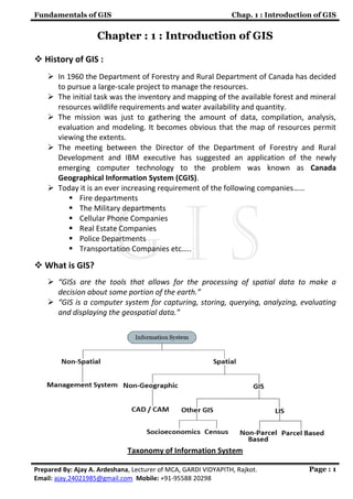
  • 1. Fundamentals of GIS Chap. 1 : Introduction of GIS Prepared By: Ajay A. Ardeshana, Lecturer of MCA, GARDI VIDYAPITH, Rajkot. Email: ajay.24021985@gmail.com Mobile: +91-95588 20298 Page : 1 Chapter : 1 : Introduction of GIS  History of GIS :  In 1960 the Department of Forestry and Rural Department of Canada has decided to pursue a large-scale project to manage the resources.  The initial task was the inventory and mapping of the available forest and mineral resources wildlife requirements and water availability and quantity.  The mission was just to gathering the amount of data, compilation, analysis, evaluation and modeling. It becomes obvious that the map of resources permit viewing the extents.  The meeting between the Director of the Department of Forestry and Rural Development and IBM executive has suggested an application of the newly emerging computer technology to the problem was known as Canada Geographical Information System (CGIS).  Today it is an ever increasing requirement of the following companies……  Fire departments  The Military departments  Cellular Phone Companies  Real Estate Companies  Police Departments  Transportation Companies etc…..  What is GIS?  “GISs are the tools that allows for the processing of spatial data to make a decision about some portion of the earth.”  “GIS is a computer system for capturing, storing, querying, analyzing, evaluating and displaying the geospatial data.” Taxonomy of Information System
  • 2. Fundamentals of GIS Chap. 1 : Introduction of GIS Prepared By: Ajay A. Ardeshana, Lecturer of MCA, GARDI VIDYAPITH, Rajkot. Email: ajay.24021985@gmail.com Mobile: +91-95588 20298 Page : 2  Applications of GIS :-  Business 1. Banking: - Financial analysts employ GIS for targeting their markets by visualizing service needs. Companies including Metropolitan Life and Chase Manhattan Bank rely on GIS software to help them improve operational excellence and profitability. 2. Insurance: - Many insurance companies have made GIS a central component of their business, using it to visualize, analyze, and distribute risk. Companies such as CHUBB Insurance use GIS software for portfolio risk management. 3. Media: - GIS is used by media bureaus for everything from analyzing circulation and attracting advertisers to creating the maps used in the material itself. The Associated Press (AP), USA TODAY, and National Geographic Society use GIS software to create accurate maps quickly for magazines, newspapers, and online news services. 4. Real Estate: - From map-based contact management to sophisticated investment analysis in large real estate investment trusts, real estate agencies rely heavily on electronic mapping. Companies such as SSR Realty Advisors, Inc. use GIS in commercial real estate, while REALTOR.com uses GIS to bring maps online to 1.2 million people shopping for a new home. 5. Logistics: - Logistics management requires planning the distribution fleet's activities, route locations, and schedules. Argentina's telephone company, Grupo Telefónica, uses the GIS logistics routing solution shown to the right to increase the number of daily deliveries without increasing resources. 6. Retail: - Businesses maintain information about sales, customers, inventory, demographic profiles, and mailing lists, all of which have geographic locations. Business managers, marketing strategists, financial analysts, and professional planners increasingly rely on GIS to organize, analyze, and present their business data.  Government 1. National Government: - Government agencies trust GIS technology to establish and regulate policy and to strengthen the welfare of their citizens. GIS is also an intelligent means for agencies to provide public information. The U.S. government relies heavily on GIS to evaluate the results of U.S. Census 2000. 2. Local Government: - Revenue collection, economic development, and public information are just a few opportunities that GIS affords municipalities. The cities of Madrid, Geneva, and Paris all use GIS for providing many city services.
  • 3. Fundamentals of GIS Chap. 1 : Introduction of GIS Prepared By: Ajay A. Ardeshana, Lecturer of MCA, GARDI VIDYAPITH, Rajkot. Email: ajay.24021985@gmail.com Mobile: +91-95588 20298 Page : 3 3. Homeland Security: - GIS assets at local, regional, and national levels are used in emergency response in the areas of detection, risk assessment, mitigation and prevention, preparedness, response, and recovery. Utilized in both natural and human-induced disasters, GIS has merged into the common operating procedures for public safety and emergency response activities. City, county, state, and federal-level agencies use GIS as a common framework for organizing and sharing data in a digital world. 4. Military Defense: - Military defense uses GIS for intelligence, terrain analysis, mission planning, and facilities management. Geographic analysis is critical in military operations, tactical or logistical planning, and infrastructure management. 5. Emergency Medical services: - GIS allows public safety personnel to effectively plan for emergency response, determine mitigation priorities, analyze historical events, and predict future events. 6. Transportation: - GIS serves three distinct transportation needs: infrastructure management, fleet and logistics management, and transit management. GIS offers insight for network planning and analysis, vehicle tracking and routing, inventory tracking, and route planning analysis.  Education and Science 1. Research: - GIS is an ideal tool to help researchers model the real world, classify and observe phenomena, and predict changes over time. Ready- made data models make it easy to work with layers of data to observe relationships and explore new methods to represent the world around us. 2. Library and Museum: - GIS creates interactive maps for museum exhibits that help visitors explore people, places, and events. GIS is also a valuable research tool used by museum scientists and researchers to increase people's understanding of natural systems and human cultures from anthropology to zoology.  Environment and Conservation 1. Water: - Environmental management and stewardship programs integrate a broad spectrum of data with the analysis tools of GIS to provide a better understanding of how elements of natural communities interact across a landscape. GIS is used worldwide in ecology labs, planning departments, parks, agencies, and nonprofit organizations to promote sustainable growth. 2. Ocean: - Marine GIS uses data from oceans and seas to represent near shore and deepwater phenomena such as current, salinity, temperature, biological and ecological mass, and density.
  • 4. Fundamentals of GIS Chap. 1 : Introduction of GIS Prepared By: Ajay A. Ardeshana, Lecturer of MCA, GARDI VIDYAPITH, Rajkot. Email: ajay.24021985@gmail.com Mobile: +91-95588 20298 Page : 4 3. Land: - Accurate information about the local landscape is critical to making decisions about what to protect and how to protect it. Digital maps of sites can be linked to a relational database that stores topography, baseline data, site documentation, and aerial digital photography. 4. Wildlife: - GIS is an important tool in habitat and species management and protection. GIS enables the study of animal populations at a variety of scales as well as analysis tools to study habitat corridors; migration patterns; and the influence of parks, reserves, and sanctuaries for wildlife conservation. 5. Vegetation :- GIS is ideal for mapping and inventorying vegetation across landscapes and to better understand threatened and endangered species inventories for scientific and managerial applications  Natural Resources 1. Agriculture :- GIS provides the analytical capabilities that form the hub of a successful precision agriculture system. GIS lets farmers perform site-specific spatial analyses of agronomic data. 2. Forestry :- Ireland's forestry service, Coillte Teoranta, uses GIS as a key component in managing its timber resources and maintaining sustainable forest management. Coillte Teoranta leverages GIS functionality for applications as diverse as land valuation, timber market analysis, harvest route planning, and landscape visualization. 3. Oil and Gas :- Where to drill, route a pipeline, or build a refinery are all questions that rely heavily on an understanding of geography  Components of GIS Like any other Information Technology, GIS requires the following five components to work with geospatial data. 1. Computer System :-  Computer system includes the computer and Operating System to run the GIS. 2. GIS Software :-  GIS Software includes the program and the user interface for driving the hardware. Common interfaces in GIS are Menus, Graphical Icons, Command lines and Scripts.  e.g. Arc Map, Arc Catalog, Arc GIS Server etc…
  • 5. Fundamentals of GIS Chap. 1 : Introduction of GIS Prepared By: Ajay A. Ardeshana, Lecturer of MCA, GARDI VIDYAPITH, Rajkot. Email: ajay.24021985@gmail.com Mobile: +91-95588 20298 Page : 5 3. People :-  Peoples refer to the GIS Professionals and users who define the purpose and objectives and provide the reasons and justification for using GIS. 4. Data :-  Data consists of the various kinds of inputs that system takes. 5. Infrastructure :-  The infrastructure refers to the necessary physical, organizational, administrative and cultural environment that supports GIS operations.  What is Geospatial Data? Geospatial Data are the data which describe the Location and Characteristics of Spatial Features such as Roads, Vegetations Stands and Land Parcels on the Earth’s Surface. Geospatial Data separate GIS from other Information Systems. Therefore before discussing the Operations of GIS we must understand the nature of Geospatial Data. For Example to describe the road, we refer to its location (where it is) and it characteristics (Length, Name, Speed Limit and Direction). The Location also called a geometry or shape, represent Geospatial Data, where as the characteristics are Attribute Data. Basically any Geospatial Data has a two components like : Spatial Data Attribute Data 1. Spatial Data :-  Spatial data describe the location of spatial features, which may be discrete or continuous.  Discrete Features are individually distinguishable features that do not exist between observation. It includes Point, Line and Areas (Polygon).  Continuous Features are features that exist spatially between observations. Examples of continuous are elevation and precipitation.  GIS represent these spatial features on the Earth’s surface as Map features on a plane surface. This transformation involves two main issues: 1. Spatial reference system 2. Data model  Location of the spatial features on the Earth’s surface are based on a geographic coordinate system with latitude and longitude values, where as the location of map features are based on the plain coordinate system with X, Y coordinates.
  • 6. Fundamentals of GIS Chap. 1 : Introduction of GIS Prepared By: Ajay A. Ardeshana, Lecturer of MCA, GARDI VIDYAPITH, Rajkot. Email: ajay.24021985@gmail.com Mobile: +91-95588 20298 Page : 6  Projection is the process the can transform the Earth’s spherical surface to a plane surface and bridge the two spatial reference system.  The Data Model defines how spatial features are represented in a GIS.  The Vector Data Model uses Points and their X and Y coordinates to constructs spatial features of Point, Line and Area (Polygon).  The Raster Data Model uses the grid and grid cells to represent the spatial variation of features. Vector data GIS Poins GIS Lines GIS Polygons Raster Data Cell Based Image Based Grid Based Vector Data Raster Data Vector Data are ideal for representing discrete features Raster data are better suited for representing continuous Features Vector formats map data by storing the spatial coordinates that define individual entities Raster formats map data by dividing space up into equal sized grids and then code each cell with the appropriate value Vector data model may be georelational or object based. Raster data model uses simple data structure with rows and columns and fixed cell location. 2. Attribute Data :-  The Attribute Data describe the characteristics of spatial features. For raster data each cell has a value that corresponds to the attribute to the spatial feature at that location.
  • 7. Fundamentals of GIS Chap. 1 : Introduction of GIS Prepared By: Ajay A. Ardeshana, Lecturer of MCA, GARDI VIDYAPITH, Rajkot. Email: ajay.24021985@gmail.com Mobile: +91-95588 20298 Page : 7  A cell is tightly bound to its cell value.  For vector data amount of attribute data to be associated with a spatial feature can vary significantly. A road may only have the attributes of length and speed limit, where as the soil polygon may have dozens of properties, interpretation and performance data.  Operations of GIS:- Spatial Data Input Data Entry : Use existing data, create new data Data Editing, Geometric Transformation Projection and Re-projection Attribute Data Management Data Entry and verification, Database Management Attribute Data Manipulation Data Display Cartographic Symbolization, Map Design Data Exploration Attribute Data Query, Spatial Data Query Data Analysis Vector Data Analysis Raster Data Analysis Terrain Mapping and Analysis Path analysis and network applications GIS Modeling Binary models, Index models Regression models, Process model  Comparison of Traditional cartography and GIS :- Trad. Cart. GIS Data Collection Arial Photography, Surveys Arial Photography, Surveys Data Processing Aggregation, Classing Liner Process Aggregation, Classing circular Process Map Production Final step Not always a final step
  • 8. Fundamentals of GIS Chap. 1 : Introduction of GIS Prepared By: Ajay A. Ardeshana, Lecturer of MCA, GARDI VIDYAPITH, Rajkot. Email: ajay.24021985@gmail.com Mobile: +91-95588 20298 Page : 8  Comparison of Input Subsystem for Analog V/s Digital GIS :- Map GIS Input Recorder on a paper from a collected source Points, line, Area Encoded in to a computer from a collected source Points, line, Area Sources Arial Photography, Digital remote sensing, Surveying, Visual description, Census data, Statistical data Same as Map data, Digital Line Graph (DLG) Digital Elevation Models, Digital Orthophotoquads, Other Digital Databases.  Comparison of Storage and Retrieval Subsystem for Analog V/s Digital GIS Map GIS Points, Line and Areas are drawn on paper with symbols. Points, Line and Areas are stored as a grid cells or coordinate pairs and pointers in computer. Retrieval is simply a matter of map reading Retrieval requires efficient computer search techniques.  Comparison of Comparison and Analysis Subsystem for Analog V/s Digital GIS :- Map GIS Requires rulers, plan meters, compasses and other tools all used by a human analyst. Uses the power of the computer to measure, compare and describe the content of the database. Restricted to the data as they are aggregated and represented on the paper map. Always ready access to the raw data and allows aggregation and reclassification for further analysis.  Comparison of Reporting and Output Subsystem for Analog V/s Digital GIS :- MAP Output GIS Output Graphic device only The map is only one type of GIS output Many forms of map With minor exceptions, GIS offers some options as traditional hand drawn maps. Modification can include cartogram Also include tables, charts, diagrams, photographs etc…