Más contenido relacionado
Similar a River Tees (20)
Más de Bourne Grammar School (18)
River Tees
- 1. RIVERS BEGIN AT THEIR
iSOURCE, high above sea
level, and flow downhill
towards their mouth, usually the
sea. For ease of study we divide
the river into three sections: the
upper, middle and lower
courses. In each of these
sections typical landforms can
be seen a result of the processes
at work. This unit investigates
these landforms and processes
along the River Tees in north-
east England.
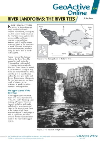
Figure 1 shows the drainage
basin of the River Tees. The
source lies high up in the
Pennines close to Cross Fell
(893 metres above sea level).
The river flows east to its mouth
in the North Sea. Along its way
there are many tributaries. They
join the river at a confluence
and so the river gets wider and
deeper downstream. Changes in
the river downstream are also a
result of changes in the
processes at work – erosion,
transport and deposition.
The upper course of the
River Tees
In the upper course the river
flows over hard, impermeable
rocks. The valley has steep sides
forming a V-shape. The river
channel is shallow and rocky
and the river is turbulent and
clear. In the upper course there
is the famous High Force
waterfall (Figure 2) and gorge as
well as rapids and potholes.
Erosion downwards is the main
work of the river in the upper
course.
Series 16 Summer issue Unit 330 River Landforms: the River Tees © 2005 Nelson Thornes GeoActive Online
This page may be photocopied for use within the purchasing institution only. Page 1 of 4
330
by Ann Bowen
RIVER LANDFORMS: THE RIVER TEES
GeoActive
Online
GeoActive
Online
Cross
Fell
Barnard
Castle
Darlington
Yarm
Middlesbrough
High Force
Cow Green
Reservoir
North
Sea
0 20 km
R. Tees
301+ 61–300 0–60
Key
N
Height (metres)
Figure 1: The drainage basin of the River Tees
Figure 2: The waterfall at High Force
- 2. There are four main processes of
erosion in the upper course:
• Hydraulic power – the force of the
water on the bed and banks of the
river.
• Corrasion – the sand and gravel
carried by the river grinds away at
the bed and banks of the river.
• Corrosion – some soluble minerals
such as calcium carbonate in
limestone dissolve in the river
water.
• Attrition – the stones, pebbles and
other materials (load) carried by the
river rub against each other making
the particles smaller and more
rounded as they move downstream.
The waterfall and gorge at High
Force
High Force is the tallest waterfall
in England at 21 metres high,
though this is pretty
disappointing when you compare
it with some of the world’s
greatest – Angel Falls in
Venezuela are the world’s tallest
at 979 metres.
At High Force, the waterfall and
its gorge of recession have been
formed over millions of years. On
Figure 2 notice the high head of
water, the deep plunge pool at
the base and how the rock type
changes. At the top of the
waterfall there is a very hard rock
called Whinsill, which is the cap
rock. Below this lie softer rocks
such as limestone, sandstone and
shale. At the edge of the plunge
pool are large boulders and rocks.
At High Force the hard Whinsill
lies on top of softer limestone and
sandstone. The river flows over
the harder rocks and erodes the
softer rocks below more quickly.
Over a long time the softer rock is
undercut and the hard cap rock
overhangs. Eventually the hard
rock collapses under the force of
gravity. The great power of the
water erodes the plunge pool. The
rocks resulting from the collapse
of the cap rock and from the
erosion of the plunge pool are
moved to the edge. As the cap
rock collapses the waterfall
retreats upstream. This is repeated
again and again causing a steep-
sided gorge of recession to be
formed. Gradually chips of rock
are also broken off the top of the
waterfall and the waterfall reduces
in height.
Potholes and rapids at Low Force
Figure 3 shows a pothole in the
river bed at Low Force. Here
small pebbles have become
trapped in hollows in the rock.
The river’s flow has caused the
pebbles to swirl around in the
hollow making it deeper and
deeper. The pebbles grind and
scrape at the bedrock, eroding the
hollow by corrasion. At Low
Force there are also rapids formed
by smaller outcrops of Whinsill.
The less resistant limestone has
been eroded away leaving the
rapids.
The middle course of the
River Tees
As the River Tees flows
downstream the gradient becomes
less steep. The river begins to
erode sideways (lateral erosion)
rather than downwards and the
river begins to deposit sand and
gravel. The lateral erosion means
the river gets wider, the river
valley gets wider and meanders
begin to form.
Meanders
A meander is a bend in the river
(Figure 4). On the outside bend of
the river the water is deeper and
flows more quickly. The force of
the water (hydraulic power) and
corrasion erode the outside bend
to form a river cliff. On the inside
bend the water is shallower and
flows more slowly. Here there is
deposition of sand and gravel
forming a slip-off slope.
As the meanders get wider they
erode away the valley floor,
creating a wider valley in a broad
U-shape. The meanders also
migrate or move downstream.
This too broadens the flood plain,
creating a line of river bluffs at the
edge of the flood plain.
GeoActive Online Series 16 Summer issue Unit 330 River Landforms: the River Tees © 2005 Nelson Thornes
Page 2 of 4 This page may be photocopied for use within the purchasing institution only.
Figure 3: A pothole at Low Force in
Upper Teesdale
Plan view Cross-section along X–Y
XX YY
Outside
bend
Inside
bend
Water level
Deepest water and
fastest current
Slip-off
slope
Deposition
Deposition
Erosion
Zone of strongest flow
Erosion
River
cliff
Key
Figure 4: Plan view and cross-section of a meander
- 3. Series 16 Summer issue Unit 330 River Landforms: the River Tees © 2005 Nelson Thornes GeoActive Online
This page may be photocopied for use within the purchasing institution only. Page 3 of 4
The lower course of the
River Tees
Close to Yarm the River Tees has
formed very large meanders.
Some of these meanders have led
to the formation of ox-bow lakes
(Figure 5) and flooding has
caused levées to form (Figure 6).
Levées are high banks of silt
along the banks of a river. They
are formed where a river flows
slowly, carries a large load of silt
and floods on occasions. When
the river floods the coarser
material is deposited first close to
the river channel. The finer
material is deposited further
away. Over many years this
coarse material builds up to form
the levées on the river bank. In
times of low flow when the river
has little water and is flowing
slowly it deposits material on the
river bed, building it up.
Gradually the river bed increases
until it is higher than the land
around. Then flooding is
disastrous as the water cannot
flow back into the river. The
lateral erosion by the meanders
and the occasional floods build
up a wide, flat flood plain on
either side of the river. Here the
valley is a broad U-shape with
quite gentle sides.
The mouth of the River Tees
The mouth of the River Tees is an
estuary. An estuary is a river valley in
a lowland area that has been
flooded. During the Ice Age vast
amounts of water were stored as
snow and ice. This caused sea levels
to be much lower than they are
now. At the end of the Ice Age the
melting of the snow and ice caused
sea levels to rise and so the lower
parts of river valleys were flooded to
form these wide estuaries. The River
Tees has a very wide estuary with
mudflats and sandbanks. The
estuary has been a magnet for
industry with iron and steel,
engineering and chemical works all
along its length. However, parts of
the estuary are very important sites
for wildlife, such as seals, and
migratory birds. Some areas are Sites
of Special Scientific Interest (SSSIs),
and are carefully managed for the
unique ecosystems they support, eg
Seal Sands.
River basin management
The drainage basin of the River Tees
has been managed for over a
century. The management has had
several aims:
• to reduce flooding
• to improve water supply
• to improve water quality
• to improve navigation
• to provide more opportunities for
recreation.
A variety of strategies have been
used, including the building of
reservoirs such as Cow Green and
Grassholme. In the 19th century,
‘cut-offs’ were built near Stockton to
straighten the river for navigation,
and recent flood protection schemes
have been built at Yarm. Today there
is a huge watersports complex at the
Tees barrage.
A meander
In the lower course, meanders are large.
Corrasion and hydraulic power erode
the outer bends and deposition builds up
the slip-off slopes.
The neck narrows
The erosion continues and the neck of
the meander narrows.
Eventually, usually in times of flood, the
neck is broken through.
The ox-bow lake is formed
The river now follows a straight path. The
meander is sealed off by deposition to form
the ox-bow lake. The lake may dry up to
form a meander scar.
Meander
neck
Neck
narrows
Ox-bow
lake
Key
Erosion
Deposition
Marsh
Fastest flow
Figure 5: Formation of an ox-bow lake
River in flood
River at low flow
After repeated floods
Coarse materialFine sand
River channel
River above
flood plain
Deposition on
river bed
Flood
plain
Levée
Figure 6: Formation of levées
- 4. 1 Tops and tails – match the word
or term with the correct definition:
2 Complete a table like the one
begun in Figure 7 to show the
main landforms and processes
along the River Tees. Try to include
actual names of places and
landforms.
3 Waterfalls and gorges
(a) Make a copy of Figure 2.
(b) Label your sketch with the
main characteristics of High Force.
Add a title.
(c) Match the numbers on Figure 8
with the following sentences. Re-
write the sentences in the correct
order to explain how waterfalls
and gorges are formed.
A The overhang collapses under gravity.
B The waterfall retreats upstream.
C Splashback from the waterfall erodes
by hydraulic power.
D A steep-sided gorge of recession is
formed.
E The softer rocks are undercut.
F The hard cap rock overhangs.
4 Meanders and levées
Access the Ordnance Survey Get-a-
Map website (http://getamap.
ordnancesurvey.co.uk). Search for
the extract for Yarm and download
and print a copy of the map.
(a) On your map add the following
labels in the most appropriate
places:
Meander Slip-off slope
River cliff Levées
Flood plain
(b) Add an arrow to show the
river’s direction of flow.
You could repeat this for maps of
Upper Teesdale and the river
mouth – practise recognising the
landforms and other features of the
river and its valley.
(c) At what height above sea level is
the river at Yarm?
(d) Approximately how wide is the
valley floor?
(e) Copy and complete the
following sentences to explain the
formation of ox-bow lakes:
In a meander, erosion by hydraulic
power and c____________ on the
outside bend leads to the formation
of a ________ __________. On the
inside bend deposition builds up a
_______ _______. Over time the
erosion on the outside bend causes
the _______ of the meander to
narrow. Eventually, usually in times
of ________, the neck is broken
through. The river follows a
straight path. The old meander is
sealed off by ___________ to form
an ox-bow lake. Eventually the ox-
bow lake dries up and a meander
scar is formed.
(f) Copy the diagrams in Figure 6
to show the formation of levées.
Add notes alongside each one to
explain how levées are formed.
5 (a) What is an estuary? In which
part of the river is it found?
(b) Explain how an estuary is
formed.
(c) Why are estuaries good sites for
settlement and industry?
6 Produce an A4 leaflet
explaining the journey of a river
from source to mouth suitable
for a pupil in Year 6 at primary
school.
GeoActive Online Series 16 Summer issue Unit 330 River Landforms: the River Tees © 2005 Nelson Thornes
Page 4 of 4 This page may be photocopied for use within the purchasing institution only.
Activities
Confluence Diagram of a river
from its source to its
mouth
Cross-section Where a river starts
Drainage basin Where a river flows
into the sea
Long profile Diagram of a river
from bank to bank
Mouth Where two rivers
meet
Source The imaginary line
around a drainage
basin
Tributary The area of land that
a river drains
Watershed A smaller river
flowing into a large
river
Upper course Middle course Lower course
Long profile
Cross-section
Valley features
Gradient
River and channel
features/landforms
Processes at work
Figure 7: Landforms and processes along the River Tees
Cap rock
(resistant
Whinsill)
Softer
sandstone
and
limestone
Plunge
pool
1
2
3
4
5
6
Former
position of
waterfall
Figure 8: The formation of High
Force and its gorge
Source
Pennines Yarm Mouth
North
Sea