Validation
•Descargar como PPTX, PDF•
0 recomendaciones•481 vistas

The purpose of this project is to compare LiDAR data collected with Ilris and DynaScan to GPS (RTK) points.

Recomendados
Recomendados
Más contenido relacionado
Similar a Validation
Similar a Validation (20)
Más de COGS Presentations
Más de COGS Presentations (20)
Último
Último (20)
Validation
- 1. DynaScan Point Validation Sammy Barnard
- 2. Work Flow Chart Field Collection • RTK • Ilris • MDL DynaScan Post Processing • Roll • Pitch • Heading Data Export • ASCII • LAS Validation • ArcMap • Excel
- 3. Field Collection • RTK • Ilris • MDL DynaScan
- 6. Create LAS Dataset •Convert LAS (.las) created in TerraScan to file type that can be viewed and processed in ArcMap (.lasd) LAS Dataset to Raster •Convert LiDAR points to a raster (grid) •Changed in order apply values to entire field Extract Values to Points •Assign raster values to GPS points Add Field •Additional field for elevation difference Field Calculator •Elevation - Extracted Value (RTK points) Export Individual Transects Methodology
- 7. Results
- 8. Calibration Lines as Grids Line 1 Line 2 Line 3
- 9. Methodology Point Easting Northing Separation (m) Distance Seaward (m) Elevation ILS_20_DEM ILS_20_GPS L_All_DEM L_ALL_GPS TRAN40004 492759.77 5071448.60 0.00 0.00 5.11 5.16 -0.05 4.93 0.18 TRAN40005 492759.98 5071449.12 0.56 0.56 4.62 4.80 -0.18 4.48 0.14 TRAN40006 492759.90 5071450.17 1.05 1.61 4.31 4.40 -0.09 4.19 0.12 TRAN40007 492759.92 5071451.27 1.10 2.71 3.85 4.08 -0.23 3.80 0.05 TRAN40008 492760.17 5071452.52 1.28 3.98 3.14 3.19 -0.05 2.98 0.16 TRAN40009 492760.21 5071453.29 0.77 4.75 2.68 2.56 0.12 2.58 0.10 TRAN40010 492760.17 5071453.92 0.63 5.38 2.00 2.00 0.00 1.77 0.23 TRAN40012 492759.77 5071457.68 3.79 9.17 1.59 1.60 -0.01 1.44 0.15 TRAN40013 492759.58 5071459.79 2.12 11.29 1.51 1.50 0.01 1.37 0.14 TRAN40014 492759.65 5071462.66 2.86 14.15 1.22 1.21 0.01 1.10 0.12 TRAN40015 492759.79 5071465.63 2.97 17.13 1.04 0.99 0.05 0.89 0.15 L1A_DEM L1A_GPS L1B_DEM L1B_GPS L2A_DEM L2A_GPS L2B_DEM L2B_GPS L3A_DEM L3A_GPS L3B_DEM L3B_GPS 5.12 -0.01 5.08 0.03 5.19 -0.08 5.16 -0.05 4.93 0.18 5.14 -0.03 4.63 -0.01 4.60 0.02 4.58 0.04 4.63 -0.01 4.48 0.14 4.75 -0.13 4.28 0.03 4.21 0.10 4.25 0.06 4.27 0.04 4.19 0.12 3.91 -0.06 3.73 0.12 3.77 0.08 3.89 -0.04 3.83 0.02 3.90 -0.05 3.03 0.11 3.01 0.13 3.01 0.13 3.02 0.12 2.98 0.16 2.37 0.31 2.35 0.33 2.44 0.24 2.36 0.32 2.60 0.08 2.78 -0.10 1.87 0.13 1.86 0.14 1.85 0.15 1.86 0.14 1.77 0.23 1.93 0.07 1.50 0.09 1.45 0.14 1.49 0.10 1.47 0.12 1.42 0.17 1.53 0.06 1.42 0.09 1.42 0.09 1.15 0.07 1.09 0.13 1.13 0.09 1.17 0.05 0.97 0.07 0.93 0.11 0.93 0.11 0.97 0.07 0.89 0.15 1.01 0.03
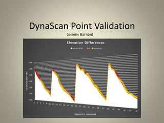
- 10. 0.00 1.00 2.00 3.00 4.00 5.00 6.00 0.00 2.00 4.00 6.00 8.00 10.00 12.00 14.00 16.00 18.00 20.00 ElevationCGVD28(m) Distance seaward (m) Elevation Elevation ILS_20_DEM L_All_DEM L1A_DEM L1B_DEM L2A_DEM L2B_DEM L3A_DEM L3B_DEM -0.30 -0.20 -0.10 0.00 0.10 0.20 0.00 2.00 4.00 6.00 8.00 10.00 12.00 14.00 16.00 18.00 20.00 Residuals(m)) Distance Seaward (m) Residuals ILS_20_GPS L_ALL_GPS L1A_GPS L1B_GPS L2A_GPS L2B_GPS L3A_GPS L3B_GPS Transect 1
- 11. 0.00 1.00 2.00 3.00 4.00 5.00 6.00 0.00 5.00 10.00 15.00 20.00 25.00 ElevationCGVD28(m) Distance Seaward (m) Elevation Elevation ILS_20_DEM L_All_DEM L1A_DEM L1B_DEM L2A_DEM L2B_DEM L3A_DEM L3B_DEM -0.20 -0.10 0.00 0.10 0.20 0.30 0.00 5.00 10.00 15.00 20.00 25.00 Residuals(m) Distance Seaward (m) Residuals ILS_20_GPS L_ALL_GPS L1A_GPS L1B_GPS L2A_GPS L2B_GPS L3A_GPS L3B_GPS Transect 2
- 12. 0.00 1.00 2.00 3.00 4.00 5.00 6.00 0.00 5.00 10.00 15.00 20.00 25.00 ElevationCGVD28(m) Distance Seaward (m) Elevation Elevation ILS_20_DEM L_All_DEM L1A_DEM L1B_DEM L2A_DEM L2B_DEM L3A_DEM L3B_DEM -0.40 -0.20 0.00 0.20 0.40 0.60 0.00 5.00 10.00 15.00 20.00 25.00 Residuals(m) Distance Seaward (m) Residual ILS_20_GPS L_ALL_GPS L1A_GPS L1B_GPS L2A_GPS L2B_GPS L3A_GPS L3B_GPS Transect 3
- 13. 0.00 1.00 2.00 3.00 4.00 5.00 6.00 0.00 2.00 4.00 6.00 8.00 10.00 12.00 14.00 16.00 18.00 ElevationCGVD28(m) Distance Seaward (m) Elevations Elevation ILS_20_DEM L_All_DEM L1A_DEM L1B_DEM L2A_DEM L2B_DEM L3A_DEM L3B_DEM -0.30 -0.20 -0.10 0.00 0.10 0.20 0.30 0.40 0.00 2.00 4.00 6.00 8.00 10.00 12.00 14.00 16.00 18.00 Residuals(m) Distance Seaward (m) Residuals ILS_20_GPS L_ALL_GPS L1A_GPS L1B_GPS L2A_GPS L2B_GPS L3A_GPS L3B_GPS Transect 4
- 14. Summary of Statistics Delta Mean Standard Deviation Ilris -0.06 0.07 All Calibration Lines 0.14 0.07 L1A 0.07 0.07 L1B 0.10 0.07 L2A 0.05 0.10 L2B 0.09 0.07 L3A 0.14 0.11 L3B 0.02 0.09
- 15. Conclusion