Exploring the Usage of Municipal Parking in Wolfville's Downtown
1. Term Research Project by James Collicutt in association with the Town of Wolfville
May 2015
2. Purpose
Data Collection & Results
Occupancy Counts
Online Survey
Department Consultation
Digital Product
ArcGIS Online Parking App
Study Limitations
Future Efforts
Acknowledgments
3.
4.
5.
6. Determine how parking is being used
Throughout the week on different days at different times
Identify deficiencies
Areas in which occupancy rates reflect issues in usage
Gather public input
Areas in which occupancy rates reflect issues in usage
Convey the findings
To members of Council, staff and the general public
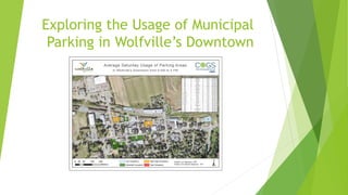
7. Occupancy Counts
Data collection took
place on nine different
occasions
Parking areas counted
hourly from 9 AM to 5 PM
Averaged into three
Excel spreadsheets
9. Occupancy Counts
Occupancy rates
separated into four
divisions:
Low Occupancy
Moderate Occupancy
Nearing High Occupancy
High Occupancy ( >85%)
10. Online Survey
Parking Periods
49% of respondents
required 1-3 Hour parking
63% of spaces in the
downtown are 1-3 Hour
32% of respondents
required All-Day parking
33% of spaces in the
downtown are All-Day
12. ArcGIS Online Parking App
Wolfville Aerial
AGOL Basemap
2012 Aerial Image
Resolution of 25 cms
Uploaded in a tile package
created in ArcMap
Occupancy Count Layers
One Weekdays, Saturdays
and Sundays
Uploaded in a feature
layer package
15. AGOL Query Widget
No ability to create
multi-part queries
Winter Weather
Reduced total number
of spaces
Useful in creating a
“worst case scenario”
16. Additional Data Collection
Spring, Summer and Fall collection periods
Attain a more complete picture of parking in the downtown
AGOL Dataset
Editing the dataset to allow for fewer queries
Using a different templates to display the data
17. Trevor Robar
Planning Technician, Town of Wolfville
Dave MacLean
COGS Faculty Advisor
Dr. Ela Dramowicz
COGS Faculty
Chrystal Fuller
Director of Community Development,
Town of Wolfville