

Recomendados
Más contenido relacionado
La actualidad más candente
La actualidad más candente (20)
Similar a Ls 106 asia
Similar a Ls 106 asia (20)
Último
Último (20)
Ls 106 asia
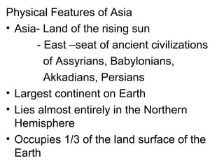
- 1. Physical Features of Asia • Asia- Land of the rising sun - East –seat of ancient civilizations of Assyrians, Babylonians, Akkadians, Persians • Largest continent on Earth • Lies almost entirely in the Northern Hemisphere • Occupies 1/3 of the land surface of the Earth
- 3. • 5 regions are identified by a combination of landforms, water forms, climate, vegetation, language, ethnicity, cultural traditions • Boundaries: N-Arctic Ocean E-Bering Strait & Pacific Ocean SW-Red Sea & Mediterranean Sea S-Indian Ocean • Ural Mountains-Europe & Asia
- 4. •Climate - the weather averaged over a long period of time • Weather - the day-to-day conditions of a particular place.
- 5. Tropical Semi-arid ArcticTemperateArid • close to the equator where the heat of the sun is felt the whole year round • Weather usually hot and humid • Home to the world’s rainforests.
- 6. Tropical Semi-arid ArcticTemperateArid Classified as: • Humid tropical climate • Tropical rain forest • Tropical monsoon climate • Tropical wet and dry savanna
- 8. Tropical Semi-arid ArcticTemperate Arid • Occur in regions with little precipitation •drier than semiarid climates •covers broad east west bands near 30° north and south latitude •in Arabian Peninsula, Northwestern part of India and North Asia
- 10. Tropical Semi-arid Arctic Temperate Arid • average temperature between 10°C- 40°C in their warmest month • average temperature between 3°C- 18°C. • Mediterranean climate, Humid Subtropical climate, Maritime temperate climate and continental climate
- 11. Tropical Semi-arid Arctic Temperate Arid Mediterranean Climate • occurs on the western sides of the continent between 30° and 45° latitude • experienced at the lowland of northern Pakistan, Southern coast of South Korea and Japan
- 13. Tropical Semi-arid Arctic Temperate Arid Maritime Temperate Climate • experiences cool summers and wild winters •Usually humid •accompanied by considerable amounts of precipitation
- 14. Tropical Semi-arid Arctic Temperate Arid Maritime Temperate Climate
- 15. Tropical Semi-arid Arctic Temperate Arid Continental Climate •Experienced in the interior of a large landmass • hot summers and cold winters • usually dry •Siberia and Central Russia
- 17. Tropical Semi-arid Arctic Temperate Arid Continental Subarctic or Taiga Climate • very cold and dry • cold snowy winters and warm summers • continental severe winter, polar climate and tundra climate
- 18. Tropical Semi-arid Arctic Temperate Arid Continental Subarctic or Taiga Climate
- 19. Factors that Affect the Asian Climate 1.Latitude - divided into four latitudinal zones a. tropical zone- 23.5° north and 23.5° south of the equator. b. subtropical zone- 23.5°to 35° north and south of the equator c. mid-latitude zone- 35° and 55° latitude. d. high latitude zone- above 55° latitude
- 21. Factors that Affect the Asian Climate 2. Oceanicity - The measure of the degree to which the climate of a region is influenced by a maritime airflow from the oceans. - Remoteness and proximity from any ocean influence climate.
- 22. 3. Monsoon - Wind system that influences large climatic regions. - May-Sept. > Southeast Monsoon or wet monsoon > HABAGAT (Philippines) - Northeast Monsoon or dry monsoon > AMIHAN (Philippines) 4. Elevation The higher the elevation the colder the temperature.
- 23. - a direct manifestation of climate the plant life or the plant ground cover of a region, not the life forms, structure, spatial extent, or any other specific botanical or geographic characteristics
- 24. Ice (No vegetation) North Pole South Pole No land Grassland No land Equator Forest Forest Grassland Desert Grassland tundra Forest Vegetation pattern
- 25. Types of Vegetation 1.Tundra Vegetation - “tundra” Russian word = “a marshy plain” - Arctic tundra and Alpine tundra
- 26. Types of Vegetation 2. Forest Vegetation a.Taiga or boreal forest- Covers the whole northern hemisphere of the high latitude lands. b. broadleaf forest- characterized by a temperate humid plant community. c.the rainforest- occur inside the earth’s equatorial regions.
- 28. Types of Vegetation 3. Grassland Vegetation - Known as “steppe” in Asia - Usually found at the highland areas of Asia particularly in West Asia, China and North Asia
- 30. Types of Vegetation 3. Desert Lands •Regions which receives an average of less than 10 inches of rainfall a year. •Evaporation is greater than rainfall •Found in the middle and lower latitudes Middle latitude > cold deserts Low latitude > hot deserts
- 31. Land forms- natural features of the earth's surface
- 32. Volcano Peninsula Hill Plain Valley Island Mountain Plateau -a place on Earth’s-a place on Earth’s surface that is muchsurface that is much higher than the landhigher than the land around itaround it Desert archipelago
- 33. Tien Shan Karakorum Kunlun Pamir Mountains
- 34. Asian mountains contain great environmental diversity, which ranges from cold and hot deserts to tropical rainforests. The Himalayas forms a continuous 2, 413 km mountain range along northern portion of the Indian subcontinent.
- 35. Mount Everest - world’s highest mountain - Lies in Nepal, Tibet border - High point reaches 8,848 meter - Leo Oracion, Erwin Emata and Romeo Garduce (Filipino)
- 36. Volcano Peninsula Hill Plain Valley Island Mountain Plateau -an opening which allows hot magma, ash and gases to escape from below the surface Desert archipelago
- 38. Volcano Peninsula Hill Plain Valley Island Mountain Plateau a low area of land between hills or mountains, typically with a river or stream flowing through it Desert archipelago
- 39. Huang Ho river Valley -rich deposit of yellow loess, provided alluvial farmlands for the Chinese.
- 40. Volcano Peninsula Hill Plain Valley Island Mountain Plateau - broad, nearly level stretches of land that have no great changes in elevation Desert archipelago
- 41. Central Plain of Luzon Asia’s plains and river valleys played an essential part in the growth and development of the early civilizations. River valleys offered abundant yield providing early Asians an opportunity to live and prosper in these places.
- 42. Volcano Peninsula Hill Plain Valley Island Mountain Plateau - a piece of land that is surrounded by water but connected to mainland via an isthmus Desert archipelago
- 44. Due to the strategic location of Asia’s Peninsulas, these landforms were developed as trading ports between nations. Kowloon Peninsula, Hong Kong
- 45. Volcanoes Peninsulas Hills Plains Valleys Islands Mountains Plateaus any area of land smaller than a continent and entirely surrounded by water. Islands may occur in oceans, seas, lakes, or rivers ex. Sri Lanka, Singapore, Maldives Deserts archipelago
- 47. Other Islands in Asia are known for their scenic beauty such as: Islands of Bali Indonesia Nicobarin Island in India Phuket Island in Thailand The islands of the continent serve as stepping places for traveling in wide oceans.
- 48. Volcano Peninsula Hill Plain Valley Island Mountain Plateau Hills are elevations of the earth's surface that have distinct summits, but are lower in elevation than mountains Desert archipelago
- 49. Volcano Peninsula Hill Plain Valley Island Mountain Plateau A plateau is a large highland area of fairly level land separated from surrounding land by steep slopes. Desert archipelago
- 50. Almost one fifth of the continent is usually made up of plateaus. Highest plateaus of Asia are located in the Himalayas. Tibetan Plateau, Highest Plateau in the world, 7,358 km high
- 51. Deccan Plateau Anatolian Plateau Arabian Plateau
- 52. Volcano Peninsula Hill Plain Valley Island Mountain Plateau Desert archipelago - a hot dry place with- a hot dry place with little or no rainlittle or no rain -- The hottest deserts of the world are found in Southwestern portion of the continent
- 53. Rub Al Khali or “empty quarter” of the Arabian Peninsula -world’s largest expanse of sand that reaches 250,000 km. - experience little or no rain at all within a year
- 54. Karakum or “black Sand, Turkmenistan Kyzylkum or “Red Sand”, Uzbekistan Thar or Great Indian Desert, Western India and Southwestern Pakistan
- 55. Dasht-e Kavir, Iran Dasht-e Lut, Iran Negev Desert, Israel Salt Deserts
- 56. Volcano Peninsula Hill Plain Valley Island Mountain Plateau Desert archipelago sometimes calledsometimes called an island group oran island group or island chain, is aisland chain, is a chain, cluster orchain, cluster or collection ofcollection of islandsislands
- 57. INDONESIA- Largest archipelago in the world JAPAN
- 58. Maldives
- 60. Lake Ocean Waterfalls Bay Gulf Sea River Strait A river is a natural watercourse, usually freshwater, flowing toward an ocean, a lake, a sea, or another river.
- 61. Asia’s rivers are the lifeblood of its people Yuan River, Largest river in China Yangtze river, longest river in Asia
- 62. Tigris and Euphrates River Yangtze and Huangho River Ganges River
- 63. Merkong River, “Mother of Waters” Chao Phraya River Cagayan River
- 64. Ob River Yenisei river Lena River Three Known Rivers of North Asia
- 65. Lake Ocean Waterfalls Bay Gulf Sea River Strait A lake is a body of water that is surrounded by land.
- 66. Asian lakes are marvelous sources of water and other resources Dead Sea -Lowest point on earth -Deepest lake in the world -Saltiest body of water on earth
- 67. Caspian Sea, largest saltwater lake in the world. Lake Baikal, contains 20% of the world’s surface freshwater
- 68. Tonle Sap, Largest freshwater lake in Southeast Asia
- 69. Lake Ocean Waterfalls Bay Gulf Sea River Strait A gulf is a portion of the ocean that penetrates land. -vary greatly in size, shape, and depth - generally larger and more deeply indented than bays
- 70. Asian gulfs had become important shipping channels among nations. Gulf of Aqaba Gulf of Suez
- 71. Gulf of Thailand, provides profitable fishing grounds for the country. Gulf of Aden, provides an outlet to the west for Persian Gulf oil.
- 72. Lake Ocean Waterfalls Bay Gulf Sea River Strait A bay is a body of water partially surrounded by land. A bay is usually smaller and less enclosed than a gulf. The mouth of the bay, where meets the ocean or lake, is typically wider than that of a gulf.
- 73. Bay Of Bengal
- 74. Lake Ocean Waterfalls Bay Gulf Sea River Strait the body of salt water covering approximately 70 percent of the earth's surface
- 75. Lake Ocean Waterfalls Bay Gulf Sea River Strait A sea generally refers to a large body of salt water, but the term is used in other contexts as well. Most commonly, the term refers to a large expanse of saline water connected with an ocean, and is commonly used as a synonym for ocean.
- 76. Lake Ocean Waterfalls Bay Gulf Sea River Strait A waterfall is a river or other body of water's steep fall over a rocky ledge into a plunge pool below. Waterfalls are also called cascades
- 77. Lake Ocean Waterfall Bay Gulf Sea River Strait A strait is a narrow body of water that connects two larger bodies of water