Continental Mapping Projects - Tualatin National Wildlife Refuge
•
0 recomendaciones•258 vistas

Continental Mapping got the privilege to perform their services in a unique set aside - an urban paradise.
Recomendados

Recomendados
Más contenido relacionado
La actualidad más candente
La actualidad más candente (20)
Destacado
Destacado (10)
Similar a Continental Mapping Projects - Tualatin National Wildlife Refuge
Similar a Continental Mapping Projects - Tualatin National Wildlife Refuge (20)
Más de Continental Mapping Consultants
Más de Continental Mapping Consultants (18)
Continental Mapping Projects - Tualatin National Wildlife Refuge
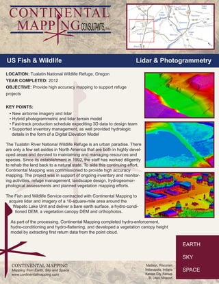
- 1. US Fish & Wildlife Lidar & Photogrammetry LOCATION: Tualatin National Wildlife Refuge, Oregon YEAR COMPLETED: 2012 OBJECTIVE: Provide high accuracy mapping to support refuge projects KEY POINTS: • New airborne imagery and lidar • Hybrid photogrammetric and lidar terrain model • Fast-track production schedule expediting 3D data to design team • Supported inventory management, as well provided hydrologic details in the form of a Digital Elevation Model CONTINENTAL MAPPING Mapping from Earth, Sky and Space www.continentalmapping.com Madison, Wisconsin Indianapolis, Indiana Kansas City, Kansas St. Louis, Missouri The Tualatin River National Wildlife Refuge is an urban paradise. There are only a few set asides in North America that are both in highly devel-oped areas and devoted to maintaining and managing resources and species. Since its establishment in 1992, the staff has worked diligently to rehab the land back to a natural state. To aide this continuing effort, Continental Mapping was commissioned to provide high accuracy mapping. The project was in support of ongoing inventory and monitor-ing activities, refuge management, landscape design, hydrogeomor-phological assessments and planned vegetation mapping efforts. The Fish and Wildlife Service contracted with Continental Mapping to acquire lidar and imagery of a 10-square-mile area around the Wapato Lake Unit and deliver a bare earth surface, a hydro-condi-tioned DEM, a vegetation canopy DEM and orthophotos. As part of the processing, Continental Mapping completed hydro-enforcement, hydro-conditioning and hydro-flattening, and developed a vegetation canopy height model by extracting first return data from the point cloud.