
Recomendados
Más contenido relacionado
Similar a EOPS_2018_09_17.pdf
Similar a EOPS_2018_09_17.pdf (20)
Más de EOPS EOPS
Último
Último (20)
EOPS_2018_09_17.pdf
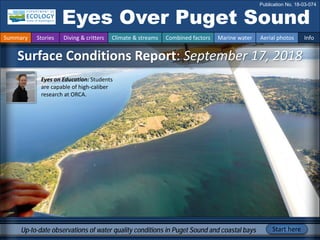
- 1. Surface Conditions Report: September 17, 2018 Eyes Over Puget Sound Publication No. 18-03-074 Up-to-date observations of water quality conditions in Puget Sound and coastal bays Start here Summary Stories Diving & critters Climate & streams Combined factors Marine water Aerial photos Info Eyes on Education: Students are capable of high-caliber research at ORCA.
- 2. Personal stories p. 4 At times, floating organic material we see in the air ends up on the shoreline where our team documents it. Climate & streams p. 7 Temperatures remain above normal, while precipitation and river flows are below normal, extending the summer’s unusual conditions. Recent rain provided a reprieve, but warmer and drier conditions are predicted for the fall. Water temperature and food web p. 11 Water temperatures were warmer in August — perhaps too warm for bull kelp and some salmon species in South Sound. These higher temperatures can increase the risk of toxin production in HABs. In contrast, Hood Canal, North Sound, and the San Juan Islands provided optimal temperature growth conditions for herring and salmon. Aerial photography p. 13 Extensive red-brown blooms are present in many terminal inlets of Puget Sound. Jellyfish patches are present in South Sound finger inlets. Floating macroalgae persist in nearshore areas of South Sound and in Useless Bay. LONG-TERM MARINE MONITORING UNIT Editorial assistance provided by: Allison Brownlee, Carol Maloy, Suzan Pool, Ruth Froese, and Jeanne Ponzetti. Summary conditions at a glance Skip Albertson Dr. Christopher Krembs (Editor) Tyler Burks Jim Shedd Summary Stories Diving & critters Climate & streams Combined factors Marine water Aerial photos Info Julianne Ruffner Laura Hermanson
- 3. ORCA received a National Science Foundation grant to help increase the number of college students studying geoscience. Possession Sound Explore student projects Contact: akveven@everettcc.edu Personal Field Impression Ocean Research College Academy — Eyes on education Ocean Research College Academy (ORCA) students are analyzing the data from Ecology water quality probes in Possession Sound, Whidbey Basin. Summary Stories Diving & critters Climate & streams Combined factors Marine water Aerial photos Info Mooring at Mount Baker Terminal Ardi Kveven, ORCA founder and executive director. “The philosophy at ORCA is that students are capable of high-caliber research, which requires dedicated time, commitment, and relationship support.”
- 4. During EOPS flights, we see patches of seagrass, algae, and jellyfish floating in the water. Wind, tides, and currents can push them onto the beach. We record the location and extent of the debris on the beaches we visit, because beached mats of algae can act as a reservoir for bacteria and can deter beachgoers. Check out the BEACH Program website for more information. What we see in the air can wash up on the beach jellyfish Jellyfish patches in Southern Hood Canal, June 2018 Beached jellyfish, Potlach, Aug 2018 Macroalgae in Central Sound, July 2018 Beached macroalgae, Dash Point State Park, Aug 2018 We sample fecal indicator bacteria on beaches because contaminated water can make you sick. boat beached beached Personal Field Impression Summary Stories Diving & critters Climate & streams Combined factors Marine water Aerial photos Info Washington BEACH Program — Eyes on the beach
- 5. Best and worst horizontal visibility and corresponding depth (ft) Station # Best (depth) Worst (depth) This is a new feature and we are soliciting feedback (skip.albertson@ecy.wa.gov). good poor visibility What was the visibility in the water for divers? What can you find underwater? Summary Stories Diving & critters Climate & streams Combined factors Marine water Aerial photos Info 1 51(67) 5(3) 2 23(51) 6(95) 3 26(3) 19(23) 4 30(77) 5(3) 5 29(85) 22(10) 6 25(56) 8(11) 7 26(87) 19(5) 8 30(66) 18(13) 9 30(98) 14(7) 10 15(54) 4(26) 11 29(97) 4(7) 12 6(5) 5(36) 13 24(66) 18(8) 14 24(98) 16(11) 15 16(54) 13(10) 16 19(8) 2(26) Aug best visibility Find depths with high/low visibility • Best visibility occurred north in Georgia Strait (station 1) at over 50 ft (67 ft depth), despite having poor visibility near the surface (5 ft depth). • Poor visibility occurred in Oakland Bay (station 12, near Shelton) and in Lynch Cove (station 10). • We use transmissometer readings from our CTD package and convert them into horizontal visibility. The poster, “Underwater Visibility Maps – a Tool for Scuba Divers”, is available here.
- 6. Dany Burgess & Angela Eagleston, Marine Sediment Monitoring Team Critter of the month — The bloodworm What can you find underwater? Summary Stories Diving & critters Climate & streams Combined factors Marine water Aerial photos Info Fun bloodworm facts • Four fang-like black jaws are made of a copper-based mineral that is as hard as your tooth enamel. • Some species can grow to over a foot long. • They are named for how their paper-thin skin reveals red body fluid inside. Family Glyceridae This critter group is one of the most common finds in our benthic samples. Bloodworms are marine segmented worms that play an important ecological role in the sediments. Learn more about bloodworms and other critters on Ecology’s EcoConnect blog here.
- 7. The maps on the top show higher probability of below-normal precipitation in the NW. The maps on the bottom show a higher probability of higher temperatures in the NW. Click here. Air temperatures were above normal while precipitation was well below normal through the first part of September (A). Though recent cooler and wetter weather has given some relief, the fall climate outlook predicts warmer and drier conditions (B). This could continue to stress freshwater inputs to Puget Sound. Average temperature Departures from average ranged from -1 to +4 degrees (F) during the past 30 days in Puget Sound. Precipitation Departures from average ranged from about -2.0 inches to about +0.5 inches during the past 30 days in Puget Sound. September 2018 Sep-Oct-Nov 2018 Precipitation Temperature B. Climate Prediction Center, NOAA A. Western Regional Climate Center How much water did we get and what can we expect? Summary Stories Diving & critters Climate & streams Combined factors Marine water Aerial photos Info Tyler Burks, Jim Shedd
- 8. Recent rainfall has been helpful, but freshwater inputs to Puget Sound are generally below normal and, in some cases, far below normal (see trend charts). Nearly all stream gages are reporting normal or below-normal flows (see map). However, most flows reporting as normal are below the 50th percentile (see charts below where the current discharge is near the bottom of the green interquartile range). Current Streamflow Conditions as of 9/13/2018 Current conditions: CLICK HERE! Select Puget Sound Streamflow Trends USGS WaterWatch: CLICK HERE! Skagit River near Mt. Vernon (12200500) Skagit River near Mt. Vernon (12200500) Puyallup River at Puyallup (12101500) Snohomish River near Monroe (12150800) Daily average discharge, in cubic feet per second How much water flows into Puget Sound? Summary Stories Diving & critters Climate & streams Combined factors Marine water Aerial photos Info
- 9. Climateinfluences:HowwellisPugetSoundexchangingits water? The Fraser River is the major driver of estuarine circulation and water exchange between the Salish Sea and the ocean. Fraser River flows continue to be lower than expected. Historically, peaks of coastal upwelling and the freshet are in sync. This year a strong freshet preceded low flows. NPGO (x10) PDO/Upwelling Index How do ocean boundary conditions affect the quality of water we exchange with the ocean? Past years’ warm water is gone (PDO) and upwelling is more likely (Upwelling Index anomaly). Unfortunately, reporting of the NPGO, which reflects the surface productivity along the coast, has been discontinued. Pacific Decadal Oscillation Index (PDO, temperature, explanation). Upwelling Index (anomalies) (Upwelling, low oxygen, explanation). North Pacific Gyre Oscillation Index (NPGO, productivity, explanation). Three-year running average of PDO, Upwelling, and NPGO Indices Summary Stories Diving & critters Climate & streams Combined factors Marine water Aerial photos Info Higher than normal Lower than normal Expected Fraser River -25 -15 -5 5 15 25 -1.5 -1 -0.5 0 0.5 1 1.5 1945 1950 1955 1960 1965 1970 1975 1980 1985 1990 1995 2000 2005 2010 2015
- 10. What influences Puget Sound’s water quality? higher No data lower expected *Upwelling/downwelling Anomalies (PFEL) PDO = Pacific Decadal Oscillation ENSO = El Niño Southern Oscillation Conditions leading up to September 2018 started similarly to those of 2017, with a cool and wet spring followed by a warm, dry, and sunny summer with low river flows. In 2018, the onset of a dry summer happened a month earlier, in May. While the pattern of sunny conditions ended earlier than in 2017, the change did not appear to influence patterns of rain or river flows, which remain below normal in August, similar to 2017. Summary Stories Diving & critters Climate & streams Combined factors Marine water Aerial photos Info Current conditions for August and September: Air temperatures remain above normal, as they have since May. Precipitation levels remain below normal, a pattern that started in May. Sunshine levels have changed in August and are variable. River flows continue to be below normal (see pages 7 and 8). Upwelling and ENSO (MEI) were neutral to slightly positive in August. All data are from public sources: UW GRAYSKIES; river flows from USGS and Environment Canada; indices from NOAA & UW (PDO).
- 11. Summary Stories Diving & critters Climate & streams Combined factors Marine water Aerial photos Info Water temperature affects ecosystem performance Warmer than expected Cooler than expected Expected 18 year average Legend: Can organisms thrive and survive? The life cycles of organisms respond to temperatures. In order to be successful, the timing of early life stages has to line up with good growth conditions. Temperature is important for growth, but also dictates if certain organisms can overwinter in Puget Sound (e.g., northern anchovy) * Help us get these right. We scoured the literature for temperatures important for the success and survival of marine organisms. Lifecycles Temperature Climate In August, water temperatures were warmer, particularly in the surface waters of South Sound. Temperatures for coho and Chinook salmon as well as bull kelp were above optimal levels, and the risk of HAB toxin production was higher. In contrast, Hood Canal, North Sound and the San Juan Islands provided optimal growth conditions for herring and salmon. Oysters like it warm! Optimal temperatures for Puget Sound organisms*
- 12. Summary Stories Diving & critters Climate & streams Combined factors Marine water Aerial photos Info A. Sinclair Inlet: river inputs (Sp1,2) B. Budd Inlet: a boat wake and internal waves A. Temperatures in marine surface waters can vary by more than 3 °C as shown in this image from Sinclair Inlet. B. A boat wake leaves a thermal footprint, bringing cooler water to the surface. The internal waves are not visible in the IR image. 9-17-2018 internal waves Gorst Disclaimer: IR images are not corrected for sky condition, humidity, air temperature, emissivity, and subject distance. Infrared (IR) images show what the eye can’t see boat wake cloud reflections Bloom jellyfish
- 13. What are the conditions at the surface? Start here Bloom Debris Front Plume Narrow Hammersley Inlet connecting Oakland Bay Mixing and fronts: Tidal fronts are pronounced in Admiralty Reach. Debris: Macroalgae are still seen in Useless Bay (southwest Whidbey Island) and in the nearshore areas of Case Inlet (South Sound). Rafts of organic material are present in Padilla Bay. Visible blooms: Red-brown blooms are present in Eld, Budd, Henderson, Sinclair, and Dyes Inlets. They were also observed in Quartermaster Harbor, northern Hood Canal, Kilisut Harbor, and Sequim Bay. Jellyfish: Jellyfish patches are in Eld and Budd Inlets, and also likely in Sinclair Inlet and Scow Bay (latter unconfirmed). Suspended sediment: Stillaguamish River is rich in sediment following recent rain. Red-brown blooms are present in many terminal inlets of Puget Sound. Jellyfish patches are in the South Sound finger inlets and likely in Sinclair Inlet and Scow Bay. Remnants of floating mats of macroalgae persist in various nearshore areas of South Sound and southwest Whidbey Island. Summary Stories Diving & critters Climate & streams Combined factors Marine water Aerial photos Info Green bloom, Higgins Slough, Swinomish Channel Unverified oil sheen north of Perego’s Lagoon sheen Perego’s Lagoon
- 14. Strait of Juan de Fuca San Juan Islands Main Basin Hood Canal Whidbey Basin Broken cloud ceiling. Flight Information: Aerial photography and navigation guide Flight routes 3 South Sound Summary Stories Diving & critters Climate & streams Combined factors Marine water Aerial photos Info 16 19 20 5 8 10 4 6 14 9 2 1 7 11 12 13 15 Padilla Bay 17 18 Tide data from September 17, 2018 (Seattle): Height (ft) High/Low 5:25 AM 1.18 L 1:15 PM 9.65 H 7:04 PM 6.74 L 11:35 PM 8.66 H
- 15. Jellyfish are back and occurring with a red-brown bloom, partially covered by cloud reflections. Location: Eld Inlet (South Sound), 12:24 PM 1 Aerial photography 9-17-2018 Navigate Summary Stories Diving & critters Climate & streams Combined factors Marine water Aerial photos Info Gravelly Beach jellyfish boat Bloom jellyfish jellyfish jellyfish cloud reflections
- 16. A. Likely jellyfish, but not confirmed. B. Large red-brown bloom near Port Orchard. Location: Sinclair Inlet (Central Sound), 12:48 PM jellyfish Gorst Bloom A. B. Port Orchard boat 2 Navigate Summary Stories Diving & critters Climate & streams Combined factors Marine water Aerial photos Info Aerial photography 9-17-2018 boat
- 17. Red-brown bloom and organic surface debris in various places in Dyes Inlet. Location: Dyes Inlet (Central Sound), 12:50 PM 3 Navigate Summary Stories Diving & critters Climate & streams Combined factors Marine water Aerial photos Info Aerial photography 9-17-2018 Oyster Bay Bloom Silverdale Bloom Tracyton Rocky Point Front Bloom Debris
- 18. Red-brown bloom in Bywater Bay. Location: Hood Head (northern Hood Canal), 1:07 PM Bloom 4 Navigate Summary Stories Diving & critters Climate & streams Combined factors Marine water Aerial photos Info Aerial photography 9-17-2018 Hood Head Bywater Bay
- 19. Red-brown bloom from northern Hood Canal, extending into Admiralty Reach. Location: Admiralty Reach (North Sound), 1:11 PM 5 Navigate Summary Stories Diving & critters Climate & streams Combined factors Marine water Aerial photos Info Aerial photography 9-17-2018 Foulweather Bluff Bloom boat boat Double Bluff
- 20. B. A. Red-brown bloom with white milky patch, likely jellyfish. B. Bloom extending north into Kilisut Harbor. Location: A. Scow Bay. B. Marrowstone Island (North Sound), 1:15 PM A. Indian Island Bloom Bloom 6 Navigate Summary Stories Diving & critters Climate & streams Combined factors Marine water Aerial photos Info Aerial photography 9-17-2018 Marrowstone Island jellyfish
- 21. 7 Navigate Summary Stories Diving & critters Climate & streams Combined factors Marine water Aerial photos Info Aerial photography 9-17-2018 Water with surfacing turbidity, likely from an underwater diffuser. Location: Port Townsend Bay (North Sound), 1:25 PM outfall barge Glen Cove Indian Island Port Townsend State Park
- 22. Vivid red-brown bloom covering large portions of Sequim Bay. Location: Sequim Bay (Strait of Juan de Fuca), 1:26 PM 8 Navigate Summary Stories Diving & critters Climate & streams Combined factors Marine water Aerial photos Info Aerial photography 9-17-2018 Bloom Sequim Bay State Park boat boat
- 23. Vivid red-brown bloom covering large portions of Sequim Bay north to Pitship Point. Location: Sequim Bay (Strait of Juan de Fuca), 1:26 PM 9 Navigate Summary Stories Diving & critters Climate & streams Combined factors Marine water Aerial photos Info Aerial photography 9-17-2018 Pitship Point Bloom boat
- 24. Mats of organic debris floating above seagrass beds and submerged tidal channels. Location: Padilla Bay (North Sound), 2:07 PM 10 Navigate Summary Stories Diving & critters Climate & streams Combined factors Marine water Aerial photos Info Aerial photography 9-17-2018 Debris Padilla Bay National Estuarine Research Reserve Debris Debris
- 25. Following an episode of rain, large amounts of sediment enter Puget Sound with the Stillaguamish River. Location: Port Susan (Whidbey Basin), 2:03 PM Navigate 11 Summary Stories Diving & critters Climate & streams Combined factors Marine water Aerial photos Info Aerial photography 9-17-2018 Stillaguamish River Plume
- 26. B. A. Navigate Patches containing large mats of macroalgae. B. Citizen provided image of macroalgae to us on Aug. 15. Location: Useless Bay (North Sound), 2:27 PM 12 Summary Stories Diving & critters Climate & streams Combined factors Marine water Aerial photos Info Aerial photography 9-17-2018 macroalgae macroalgae
- 27. Navigate Red-brown bloom and river plume revealing interesting flow pattern in surface water. Location: Quartermaster Harbor (Central Sound), 2:48 PM 13 Summary Stories Diving & critters Climate & streams Combined factors Marine water Aerial photos Info Aerial photography 9-17-2018 Bloom Hand Portage Plume Bloom
- 28. Large red-brown bloom originating off the town of Dockton in locally warmer water. Location: Quartermaster Harbor (Central Sound), 2:49 PM Navigate 14 Summary Stories Diving & critters Climate & streams Combined factors Marine water Aerial photos Info Aerial photography 9-17-2018 Maury Island Bloom 14.4 °C 14.7 °C 13.7 °C 13.3 °C
- 29. Red-brown bloom in Henderson Inlet. Location: Henderson Inlet (South Sound), 3:03 PM Navigate 15 Summary Stories Diving & critters Climate & streams Combined factors Marine water Aerial photos Info Aerial photography 9-17-2018 boat Bloom Woodard Bay cloud reflections pier boat
- 30. Red-brown bloom highlighting the patchy nature that blooms sometimes have. Location: Budd Inlet (South Sound), 3:05 PM Navigate 16 Summary Stories Diving & critters Climate & streams Combined factors Marine water Aerial photos Info Aerial photography 9-17-2018 Cooper Point cloud reflections cloud reflections Bloom Gull Harbor boat
- 31. Red-brown bloom and patches of jellyfish near entrance channel and East and West Bays. Location: Budd Inlet (South Sound), 3:07 PM Navigate 17 Summary Stories Diving & critters Climate & streams Combined factors Marine water Aerial photos Info Aerial photography 9-17-2018 Priest Point Bloom jellyfish jellyfish
- 32. Internal waves traveling through a red-brown bloom reveal that the bloom is at the water surface. Location: Budd Inlet (South Sound), 3:08 PM Navigate 18 Summary Stories Diving & critters Climate & streams Combined factors Marine water Aerial photos Info Aerial photography 9-17-2018 cloud reflections boat Bloom boat internal waves
- 33. Large red-brown bloom with jellyfish and internal waves. Location: Budd Inlet (South Sound), 3:09 PM Navigate 19 Summary Stories Diving & critters Climate & streams Combined factors Marine water Aerial photos Info Aerial photography 9-17-2018 internal waves internal waves jellyfish cloud reflections boat Bloom
- 34. Internal waves reveal that flagellate red-brown blooms are often at the water surface. Location: Budd Inlet (South Sound), 3:09 PM Navigate 20 Summary Stories Diving & critters Climate & streams Combined factors Marine water Aerial photos Info Aerial photography 9-17-2018 Big Tykle Cove internal waves cloud reflections Bloom cloud reflections
- 35. Find past editions of EOPS Summary Stories Diving & critters Climate & streams Combined factors Marine water Aerial photos Info We have published 76 editions! Recommended Citation: Washington State Department of Ecology. 2018. Eyes Over Puget Sound: Surface Conditions Report, September 17, 2018. Ecology Publication No. 18-03-074. https://fortress.wa.gov/ecy/publications/documents/1803074.pdf. Find all previous Eyes Over Puget Sound editions at the end of this document. Contact: Dr. Christopher Krembs Christopher.Krembs@ecy.wa.gov Marine Monitoring Unit Environmental Assessment Program Washington State Department of Ecology You may subscribe or unsubscribe to the Eyes Over Puget Sound email listserv. Many thanks to our business partners: Shannon Point Marine Lab (WWU), Swantown Marina, Kenmore Air, and Integral Consulting for the loan of the infrared camera.
- 36. Month_date_year, Publication No. 20-03-07X Month_date_year, Publication No. 20-03-07X Month_date_year, Publication No. 20-03-07X Month_date_year, Publication No. 20-03-07X March_16_2020, Publication No. 20-03-071 Jan_10_2020, Publication No. 20-03-070 October_30_2019, Publication No. 19-03-076 September_12_2019, Publication No. 19-03-075 July_29_2019 Publication No. 19-03-074 June_4_2019, Publication No. 19-03-073 March_26_2019, Publication No. 19-03-072 February_21_2019, Publication No. 19-03-071 January_10_2019, Publication No. 19-03-070 November_6_2018, Publication No. 18-03-075 September_17_2018, Publication No. 18-03-074 July_16_2018, Publication No. 18-03-073 June_28_2018, Publication No. 18-03-072 May_22_2018, Publication No. 18-03-025 April_19_2018, Publication No. 18-03-071 Winter_2018, Publication No. 18-03-070
- 37. October_31_2017, Publication No. 17-03-073 August_28_2017, Publication No. 17-03-072 July_24_2017, Publication No. 17-03-071 June_6_2017, Publication No. 17-03-070 December_31_2016, Publication No. 16-03-079 November_22_2016, Publication No. 16-03-078 September_26_2016, Publication No. 16-03-077 August_24_2016, Publication No. 16-03-076 July_20_2016, Publication No. 16-03-075 June_27_2016, Publication No. 16-03-074 May_2_2016, Publication No. 16-03-073 April_6_2016, Publication No. 16-03-072 March_16_2016, Publication No. 16-03-071 February_8_2016, Publication No. 16-03-070 December_30_2015, Publication No. 15-03-080 December_14_2015, Publication No. 15-03-079 October_6_2015, Publication No. 15-03-078 September_21_2015, Publication No. 15-03-077 August_8_2015, Publication No. 15-03-076 July_6_2015, Publication No. 15-03-075
- 38. June_8_2015, Publication No. 15-03-074 April_29_2015, Publication No. 15-03-073 March_24_2015, Publication No. 15-03-072 February_17_2015, Publication No. 15-03-071 January_28_2015, Publication No. 15-03-070 December_30_2014, Publication No. 14-03-080 November_17_2014, Publication No. 14-03-079 October_29_2014, Publication No. 14-03-078 September_16_2014, Publication No. 14-03-077 August_18_2014, Publication No. 14-03-076 July_28_2014, Publication No. 14-03-075 June_23_2014, Publication No. 14-03-074 May_12_2014, Publication No. 14-03-073 April_21_2014, Publication No. 14-03-072 March_24_2014, Publication No. 14-03-071 February_4_2014, Publication No. 14-03-070 December_31_2013, Publication No. 13-03-081 November_21_2013, Publication No. 13-03-080 October_28_2013, Publication No. 13-03-079 September_11_2013, Publication No. 13-03-078
- 39. August_21_2013, Publication No. 13-03-077 July_15_2013, Publication No. 13-03-076 June_17_2013, Publication No. 13-03-075 May_20_2013, Publication No. 13-03-074 April_8_2013, Publication No. 13-03-073 Mar_25_2013, Publication No. 13-03-072 February_26_2013, Publication No. 13-03-071 January_15_2013, Publication No. 13-03-070 December_13_2012, Publication No. 12-03-081 November_8_2012, Publication No. 12-03-080 October_8_2012, Publication No. 12-03-079 September_11_2012, Publication No. 12-03-078 August_27_2012, Publication No. 12-03-077 July_31_2012, Publication No. 12-03-076 June_12_2012, Publication No. 12-03-075 May_14_2012, Publication No. 12-03-074 April_23_2012, Publication No. 12-03-073 March_19_2012, Publication No. 12-03-072 February_27_2012, Publication No. 12-03-071 January_30_2012, Publication No. 12-03-070
- 40. December_5_2011, Publication No. 11-03-082 November_15_2011, Publication No. 11-03-081 October_17_2011, Publication No. 11-03-080 September_12_2011, Publication No. 11-03-079 August_8_2011, Publication No. 11-03-078 July_6_2011, Publication No. 11-03-077 June_20_2011, Publication No. 11-03-076 June_6_2011, Publication No. 11-03-075 May_4_2011, Publication No. 11-03-074 April_27_2011, Publication No. 11-03-073