
Recomendados
Más contenido relacionado
Similar a EOPS_2019_02_21.pdf
Similar a EOPS_2019_02_21.pdf (20)
Más de EOPS EOPS
Último
Último (20)
EOPS_2019_02_21.pdf
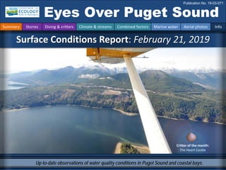
- 1. Up-to-date observations of water quality conditions in Puget Sound and coastal bays. Critter of the month: The Heart Cockle Surface Conditions Report: February 21, 2019 Eyes Over Puget Sound Publication No. 19-03-071 Summary Stories Diving & critters Climate & streams Combined factors Marine water Aerial photos Info
- 2. Personal stories p. 3 New publication featuring our marine monitoring data! Climate & streams p. 6 Fall and winter were warm, yet February was cold and snowy. Despite lowland snow, river flows were lower than expected because precipitation was generally low. Water temperature and food web p. 10 This time of the year, Hood Canal is a thermal refuge for cold-sensitive species. Aerial photography p. 11 The productive season has already started in Hood Canal and Holmes Harbor. Jellyfish are present in Eld and Budd Inlets, and we think we see some activity of spawning herring and schools of fish and many sea lions. LONG-TERM MARINE MONITORING UNIT Editorial assistance provided by: Julianne Ruffner, Carol Maloy, Suzan Pool, Valerie Partridge, Ruth Froese. Summary conditions at a glance Skip Albertson Dr. Christopher Krembs (Editor) Tyler Burks Jim Shedd Summary Stories Diving & critters Climate & streams Combined factors Marine water Aerial photos Info Julia Bos Carol Maloy
- 3. Twenty-five years of Ecology’s data contribute to understanding ocean acidification. Changes in pH over time were about five times greater than those predicted from atmospheric CO2 changes alone. Dissolved oxygen saturation had a much greater effect on pH than atmospheric CO2, temperature, or salinity. Collectively, these observations provide evidence that we need to understand local ecosystem processes (altered riverine inputs, eutrophication, etc.) in order to understand how ocean acidification affects our estuaries. http://www.nature.com/articles/s41598-018-37764-4 New publication featuring our marine monitoring data! Personal Field Impression Summary Stories Diving & critters Climate & streams Combined factors Marine water Aerial photos Info Washington State is invested in OA monitoring “Ecosystem metabolism drives pH variability and modulates long-term ocean acidification in the Northeast Pacific coastal ocean.” Alexander T. Lowe, Julia Bos, & Jennifer Ruesink
- 4. January best visibility Best and worst horizontal visibility at corresponding vertical depth This is a new feature and we are soliciting feedback (skip.albertson@ecy.wa.gov). Good Poor Visibility What was the water visibility like for divers? What can you find underwater? Summary Stories Diving & critters Climate & streams Combined factors Marine water Aerial photos Info Location Best Visibility Worst Visibility Horizontal Distance (ft.) Vertical Depth (ft.) Horizontal Distance (ft.) Vertical Depth (ft.) 1 20 5 15 75 2 11 16 2 2 3 16 87 15 18 4 23 62 13 3 5 17 16 16 94 6 23 90 4 15 7 24 5 21 98 8 35 95 23 3 9 37 77 11 3 10 23 3 12 52 11 66 51 2 8 12 37 94 23 7 13 58 39 2 7 14 38 64 14 3 15 5 62 4 3 16 23 16 22 80 17 21 97 17 5 18 16 15 12 62 Find depths with high/low visibility • Best visibility occurred in Hood Canal near Octopus Hole (location 11) with 66 ft visiblity (at 51 ft depth), despite having very poor visibility near the surface. • Poor visibility occurred in Oakland Bay near Shelton (location 15) and in Hood Canal locations 11 and 13 near the surface (no diver icon) • The poster, “Underwater Visibility Maps – a Tool for Scuba Divers,” is available here. (only best visibility shown)
- 5. Angela Eagleston & Dany Burgess Marine Sediment Monitoring Team Critter of the Month – The Heart Cockle What can you find underwater? Summary Stories Diving & critters Climate & streams Combined factors Marine water Aerial photos Info Fun Heart Cockle Facts • They have the amazing ability to “leap“ away from danger. • They have tiny tentacles that help them “smell” predators. • They have something in common with trees – can you guess what it is? Clinocardium nuttallii February’s critter shows that our hearts are in our work – literally! The heart cockle may look like just another ordinary bivalve, but this heart is a deep ocean of secrets. Find out more about the heart cockle’s hidden talents on our latest blog! Image, Dave Cowles, wallawalla.edu Image, Dave Cowles, wallawalla.edu Learn more about the heart cockle and other critters on Ecology’s EcoConnect blog here
- 6. In February, Puget Sound air temperatures were below normal and precipitation remained mostly below normal despite lowland snow (A). The spring climate outlook predicts above- normal temperature, while the precipitation prediction is mixed (B). Snowpack remains below normal despite recent gains (not shown) and could lead to summer streamflow deficits. A. Northwest Climate Toolbox B. Climate Prediction Center, NOAA Temperature Precipitation Temperature Precipitation Temperature Anomaly from historical mean daily ranged from -2 to -4 °F in the Puget Sound region during the past 30 days. Precipitation Anomaly from historical mean ranged from -5 to +3 inches in the Puget Sound region during the past 30 days. There is an equal probability that precipitation will be above, normal, or below average. March-April-May2019 Climate outlook for spring predicts there is an elevated probability that temperature will be above normal in Puget Sound. How much water did we get and what can we expect? Summary Stories Diving & critters Climate & streams Combined factors Marine water Aerial photos Info
- 7. Despite lowland snow, streamflow levels have continued to decline during February due to cold and dry conditions (see trend charts). Nearly all stream gages are reporting flows below 10% of normal, except for those with melting low-elevation snow (see map). Cold conditions are reducing snow-melt runoff at a larger range of elevations than is typically experienced this time of year, especially with reduced precipitation. Daily average discharge, in cubic feet per second How much water flows into Puget Sound? Summary Stories Diving & critters Climate & streams Combined factors Marine water Aerial photos Info Select Puget Sound Streamflow Trends Daily average discharge, in cubic feet per second Current Streamflow Conditions as of 2/28/2019 Current conditions: CLICK HERE! USGS WaterWatch: CLICK HERE!
- 8. Climateinfluences:HowwellisPugetSoundexchangingits water? The Fraser River is the major driver of estuarine circulation and water exchange between the Salish Sea and the ocean. Fraser River flows are currently very much expected. Historically, the peaks of coastal upwelling and the freshet are in sync. In 2018 a strong freshet preceded low flows. NPGO (x10) PDO/Upwelling Index How do ocean boundary conditions affect the quality of water we exchange with the ocean? Past years’ warm water is gone (PDO) and upwelling is expected (Upwelling Index anomaly). NPGO, which reflects the surface productivity along the coast, is expected as well. Pacific Decadal Oscillation Index (PDO, temperature, explanation). Upwelling Index (anomalies) (Upwelling, low oxygen, explanation). North Pacific Gyre Oscillation Index (NPGO, productivity, explanation). Three-year running average of PDO, Upwelling, and NPGO Indices Summary Stories Diving & critters Climate & streams Combined factors Marine water Aerial photos Info Higher than normal Lower than normal Expected Fraser River -25 -15 -5 5 15 25 -1.5 -1 -0.5 0 0.5 1 1.5 1945 1950 1955 1960 1965 1970 1975 1980 1985 1990 1995 2000 2005 2010 2015 2020
- 9. What influences Puget Sound’s water quality? higher No data lower expected *Upwelling/downwelling Anomalies (PFEL) PDO = Pacific Decadal Oscillation ENSO = El Niño Southern Oscillation In the anomaly plot we want to connect different factors influencing water quality in context of space and time. Conditions leading up to February 2019 were warmer and slightly drier. This is different than fall and winter 2017, where conditions were cooler but wetter. In 2018, fall and early winter were generally sunnier than the year before. February, however, is breaking this pattern (see page 6). Summary Stories Diving & critters Climate & streams Combined factors Marine water Aerial photos Info All data are from public sources: UW GRAYSKIES; river flows from USGS and Environment Canada; indices from NOAA & UW (PDO). Conditions leading up to February: Air temperatures have generally been warmer for the past several months in fall 2018, and are also warmer than fall 2017. Precipitation for the past four months has been lower than in 2017. Sunshine (opposite of cloud cover) has been consistently higher than the previous winter. River flows from USGS were recently unavailable. Upwelling and ENSO (MEI) were more moderate in 2018 than 2017. No data because of government shutdown
- 10. Summary Stories Diving & critters Climate & streams Combined factors Marine water Aerial photos Info Water temperature affects ecosystem performance Warmer than expected Cooler than expected Expected 18-year average Legend: Can organisms thrive and survive? The life cycles of organisms respond to temperature. To be successful, the timing of early life stages must line up with good growth conditions. Temperature is important for growth, but also dictates if certain organisms can overwinter in Puget Sound (e.g., northern anchovy). * Help us get these right. We scoured the literature for temperatures important to the success and survival of marine organisms. Lifecycles Temperature Climate In January, average water temperatures in surface water 0 – 30m were warmer than the baseline (1999 – 2016). Hood Canal remained the warmest, providing a thermal refuge for cold-water intolerant species. North Sound and San Juan Islands were cooler. If cooling continues, anchovies that only tolerate temperatures above 8 °C will be trapped in Hood Canal. Optimal temperatures for Puget Sound organisms*
- 11. What are the conditions at the surface? Start here Bloom Debris Front Plume Narrow Hammersley Inlet connecting Oakland Bay Mixing and fronts: Distinct fronts in Admiralty Reach, Port Madison, and Commencement Bay. Debris: Unusual patches of organic material for February in Budd Inlet, Hood Canal, and Commencement Bay near Vashon Island. Visible blooms: Strong red-brown bloom in Holmes Harbor. Some turquoise discoloration suggesting fine sediments, not blooms in South and Central Sound. Jellyfish and fish: Jellyfish patches in Eld and Budd Inlets. Spawning herring in Quilcene Bay, Squaxin Island, and Skunk Bay. Schooling fish in Scow Bay. Suspended sediment: Suspended sediment in North Sound. Suspended sediment of Nisqually River does not extend far into Nisqually Reach this winter. Brown water of smaller creeks is visible in many places as it enters Puget Sound. The productive season has already started in Hood Canal and Holmes Harbor (Whidbey Basin), despite colder temperatures. Jellyfish are present in Eld and Budd Inlets. We saw indications of spawning herring and schools of fish in Dabob Bay, Squaxin Island, and places near Admiralty Reach. Suspended sediment makes the distinction between sediment and spawning fish prone to error. Summary Stories Diving & critters Climate & streams Combined factors Marine water Aerial photos Info Large sea lion aggregation > 50 individuals, Case Inlet Different water masses entering Colvos Passage on low tide Gig Harbor Steven Jeffries, DFW: “There are 150 – 250 sea lions in South Sound since November feeding on anchovies.” Click for video (here).
- 12. Flight Strait of Juan de Fuca San Juan Islands Main Basin Hood Canal Whidbey Basin Sunny and windy toward north Flight Observations Aerial navigation guide Flight route South Sound Summary Stories Diving & critters Climate & streams Combined factors Marine water Aerial photos Info 8 10 4 6 9 7 Padilla Bay Tide data from February 21, 2019 (Seattle): Time Pred High/Low 06:25 AM 12.80 H 12:21 PM 3.71 L 5:56 PM 11.24 H 2 3 Map Key 1 5 11 12 13 14 15 16 17 18 19 20
- 13. Large ribbon of reddish-orange material accumulating at front. Location: Budd Inlet (South Sound), 11:25 AM 1 Aerial photography 2-21-2019 Navigate Summary Stories Diving & critters Climate & streams Combined factors Marine water Aerial photos Info Debris Debris cloud reflection Big Tykle Cove
- 14. Jellyfish aggregations of this size appear early this year. Boggy water entering from Green Cove Creek. Location: Eld Inlet (South Sound), 11:31 AM 2 Navigate Summary Stories Diving & critters Climate & streams Combined factors Marine water Aerial photos Info Aerial photography 2-21-2019 boat jellyfish Green Cove Plume cloud reflection cloud shadow Gravelly Beach
- 15. Suspended sediment over mussel beds appears to have been applied by boat to shellfish beds. Location: Hudson Cove, Totten Inlet (South Sound), 11:32 AM 3 Navigate Summary Stories Diving & critters Climate & streams Combined factors Marine water Aerial photos Info Aerial photography 2-21-2019 Hudson Cove Debris boat sediment cloud shadow pens Cougar Point Quarters Point
- 16. Orange organic debris and what appears to be spawning herring. Location: Squaxin Island (South Sound), 11:37 AM 4 Navigate Summary Stories Diving & critters Climate & streams Combined factors Marine water Aerial photos Info Aerial photography 2-21-2019 spawning? Debris cloud shadow cloud reflection Tucksel Point
- 17. Plume of the Sherwood Creek extending across North Bay. Location: Case Inlet (South Sound), 11:56 AM 5 Navigate Summary Stories Diving & critters Climate & streams Combined factors Marine water Aerial photos Info Aerial photography 2-21-2019 Sherwood Creek Plume Debris boat
- 18. Sizable rafts of organic material present in Hood Canal from Belfair State Park to Lilliwaup. Location: Sunset Beach, (Hood Canal), 11:58 AM Sunset Beach 6 Navigate Summary Stories Diving & critters Climate & streams Combined factors Marine water Aerial photos Info Aerial photography 2-21-2019 Debris Debris Debris Debris WCC intern Holly Young holding plankton sample. 2/28/2019
- 19. 7 Navigate Summary Stories Diving & critters Climate & streams Combined factors Marine water Aerial photos Info Aerial photography 2-21-2019 Coloration difference between suspended sediment and what appears to be spawning herring. Location: Quilcene Bay, Dabob Bay (Hood Canal), 12:23 PM pens Frenchmans Point sh spawning? sediment Fishermans Point
- 20. Whitish glow at deeper fringes of the seagrass bed: spawning herring or something else? Location: Dabob Bay (Hood Canal), 12:23 PM 8 Navigate Summary Stories Diving & critters Climate & streams Combined factors Marine water Aerial photos Info Aerial photography 2-21-2019 spawning? seagrass Camp Discovery
- 21. Incoming tide suspending fine sediment flowing past Klapot Point into Sequim Bay. Location: Sequim Bay (North Sound), 12:40 PM 9 Navigate Summary Stories Diving & critters Climate & streams Combined factors Marine water Aerial photos Info Aerial photography 2-21-2019 sediment shoal shoal sediment seagrass
- 22. Suspended sediment along shoreline facing waves and northerly winds makes spotting herring impossible. Location: Discovery Bay (North Sound), 12:44 PM 10 Navigate Summary Stories Diving & critters Climate & streams Combined factors Marine water Aerial photos Info Aerial photography 2-21-2019 Beckett Point sediment sediment seagrass
- 23. Schooling fish, likely herring, in Scow Bay. Suspended sediment. Location: Between Marrowstone and Indian Island (Central Sound), 12:51 PM 11 Navigate Summary Stories Diving & critters Climate & streams Combined factors Marine water Aerial photos Info Aerial photography 2-21-2019 fish fish fish fish fish fish sediment seagrass Bishops Point Mystery Bay
- 24. A. Large container ship anchored in Holmes Harbor. B. Red-brown bloom in across entire bay. Location: Holmes Harbor (Whidbey Basin), 12:58 PM boat ship Bloom Bloom Camano Island Whidbey Island Whidbey Island A. B. 12 Navigate Summary Stories Diving & critters Climate & streams Combined factors Marine water Aerial photos Info Aerial photography 2-21-2019
- 25. Large tidal front stretching from Marrowstone Island A. to Point No Point B. Location: Admiralty Reach (Central Sound), 1:01 PM Debris barge Point No Point Double Bluff Marrowstone Island A. B. 13 Navigate Summary Stories Diving & critters Climate & streams Combined factors Marine water Aerial photos Info Aerial photography 2-21-2019
- 26. Could this be spawning herring north of Skunk Bay (not confirmed)? Location: Admiralty Reach (Central Sound), 1:01 PM 14 Navigate Summary Stories Diving & critters Climate & streams Combined factors Marine water Aerial photos Info Aerial photography 2-21-2019 boat barge spawning? boat Skunk Bay
- 27. Two distinct water masses at the entrance to Port Madison. Potentially spawning herring near dock? Location: Port Madison (Central Sound), 1:09 PM 15 Navigate Summary Stories Diving & critters Climate & streams Combined factors Marine water Aerial photos Info Aerial photography 2-21-2019 boat Hedley Spit spawning?
- 28. Image shows how ribbons of river plumes can extend far. Here a plume reaches into Keyport lagoon. Location: Liberty Bay (Central Sound), 1:11 PM 16 Navigate Summary Stories Diving & critters Climate & streams Combined factors Marine water Aerial photos Info Aerial photography 2-21-2019 seagrass Plume Keyport Lagoon Keyport
- 29. Very boggy water from Curley Creek entering Yukon Harbor. Location: Budd Inlet (Central Sound), 1:22 PM 17 Navigate Summary Stories Diving & critters Climate & streams Combined factors Marine water Aerial photos Info Aerial photography 2-21-2019 Plume ship ship Blake Island Bainbridge Island
- 30. Suspended sediment and potentially spawning herring at Neill Point. Debris aggregating at fronts. Location: Vashon Island, Commencement Bay (Central Sound), 1:29 PM 18 Navigate Summary Stories Diving & critters Climate & streams Combined factors Marine water Aerial photos Info Aerial photography 2-21-2019 sediment ship boat spawning? Debris Neill Point
- 31. Strong front outlining the Nisqually River plume carrying sediment. Location: Nisqually Reach (South Sound), 1:39 PM 19 Navigate Summary Stories Diving & critters Climate & streams Combined factors Marine water Aerial photos Info Aerial photography 2-21-2019 Plume Debris ship ferry Anderson Island Nisqually River Ketron Island cabin reflection
- 32. Jellyfish patch and internal waves at the margins of the Deschutes River plume. Location: Budd Inlet (South Sound), 1:44 PM 20 Navigate Summary Stories Diving & critters Climate & streams Combined factors Marine water Aerial photos Info Aerial photography 2-21-2019 jellyfish internal waves boat cloud reflection Gull Harbor
- 33. Find past editions of EOPS on the next pages Summary Stories Diving & critters Climate & streams Combined factors Marine water Aerial photos Info We have published 79 editions! Recommended Citation (example e.g., September): Washington State Department of Ecology. 2018. Eyes Over Puget Sound: Surface Conditions Report, September 17, 2018. Ecology Publication No. 18-03-075. https://fortress.wa.gov/ecy/publications/documents/1803075.pdf. Find all previous Eyes Over Puget Sound editions at the end of this document. Contact: Dr. Christopher Krembs Christopher.Krembs@ecy.wa.gov Marine Monitoring Unit Environmental Assessment Program Washington State Department of Ecology Subscribe to the Eyes Over Puget Sound email listserv. Many thanks to our business partners: Shannon Point Marine Lab (WWU), Swantown Marina, Kenmore Air.
- 34. Month_date_year, Publication No. 20-03-07X Month_date_year, Publication No. 20-03-07X Month_date_year, Publication No. 20-03-07X Month_date_year, Publication No. 20-03-07X March_16_2020, Publication No. 20-03-071 Jan_10_2020, Publication No. 20-03-070 October_30_2019, Publication No. 19-03-076 September_12_2019, Publication No. 19-03-075 July_29_2019 Publication No. 19-03-074 June_4_2019, Publication No. 19-03-073 March_26_2019, Publication No. 19-03-072 February_21_2019, Publication No. 19-03-071 January_10_2019, Publication No. 19-03-070 November_6_2018, Publication No. 18-03-075 September_17_2018, Publication No. 18-03-074 July_16_2018, Publication No. 18-03-073 June_28_2018, Publication No. 18-03-072 May_22_2018, Publication No. 18-03-025 April_19_2018, Publication No. 18-03-071 Winter_2018, Publication No. 18-03-070
- 35. October_31_2017, Publication No. 17-03-073 August_28_2017, Publication No. 17-03-072 July_24_2017, Publication No. 17-03-071 June_6_2017, Publication No. 17-03-070 December_31_2016, Publication No. 16-03-079 November_22_2016, Publication No. 16-03-078 September_26_2016, Publication No. 16-03-077 August_24_2016, Publication No. 16-03-076 July_20_2016, Publication No. 16-03-075 June_27_2016, Publication No. 16-03-074 May_2_2016, Publication No. 16-03-073 April_6_2016, Publication No. 16-03-072 March_16_2016, Publication No. 16-03-071 February_8_2016, Publication No. 16-03-070 December_30_2015, Publication No. 15-03-080 December_14_2015, Publication No. 15-03-079 October_6_2015, Publication No. 15-03-078 September_21_2015, Publication No. 15-03-077 August_8_2015, Publication No. 15-03-076 July_6_2015, Publication No. 15-03-075
- 36. June_8_2015, Publication No. 15-03-074 April_29_2015, Publication No. 15-03-073 March_24_2015, Publication No. 15-03-072 February_17_2015, Publication No. 15-03-071 January_28_2015, Publication No. 15-03-070 December_30_2014, Publication No. 14-03-080 November_17_2014, Publication No. 14-03-079 October_29_2014, Publication No. 14-03-078 September_16_2014, Publication No. 14-03-077 August_18_2014, Publication No. 14-03-076 July_28_2014, Publication No. 14-03-075 June_23_2014, Publication No. 14-03-074 May_12_2014, Publication No. 14-03-073 April_21_2014, Publication No. 14-03-072 March_24_2014, Publication No. 14-03-071 February_4_2014, Publication No. 14-03-070 December_31_2013, Publication No. 13-03-081 November_21_2013, Publication No. 13-03-080 October_28_2013, Publication No. 13-03-079 September_11_2013, Publication No. 13-03-078
- 37. August_21_2013, Publication No. 13-03-077 July_15_2013, Publication No. 13-03-076 June_17_2013, Publication No. 13-03-075 May_20_2013, Publication No. 13-03-074 April_8_2013, Publication No. 13-03-073 Mar_25_2013, Publication No. 13-03-072 February_26_2013, Publication No. 13-03-071 January_15_2013, Publication No. 13-03-070 December_13_2012, Publication No. 12-03-081 November_8_2012, Publication No. 12-03-080 October_8_2012, Publication No. 12-03-079 September_11_2012, Publication No. 12-03-078 August_27_2012, Publication No. 12-03-077 July_31_2012, Publication No. 12-03-076 June_12_2012, Publication No. 12-03-075 May_14_2012, Publication No. 12-03-074 April_23_2012, Publication No. 12-03-073 March_19_2012, Publication No. 12-03-072 February_27_2012, Publication No. 12-03-071 January_30_2012, Publication No. 12-03-070
- 38. December_5_2011, Publication No. 11-03-082 November_15_2011, Publication No. 11-03-081 October_17_2011, Publication No. 11-03-080 September_12_2011, Publication No. 11-03-079 August_8_2011, Publication No. 11-03-078 July_6_2011, Publication No. 11-03-077 June_20_2011, Publication No. 11-03-076 June_6_2011, Publication No. 11-03-075 May_4_2011, Publication No. 11-03-074 April_27_2011, Publication No. 11-03-073