SlideShare una empresa de Scribd logo
1 de 45
Descargar para leer sin conexión
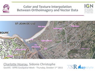
Color and Texture Interpolation
Between Orthoimagery and Vector Data
Charlotte Hoarau, Sidonie Christophe
GeoVIS - ISPRS GeoSpatial Week - Thursday, October 1srt 2015
CONTEXT and CHALLENGES
Hybrid visualization between maps and imagery
3C. Hoarau, S. Christophe GeoVIS – ISPRS GeoSpatial Week
Long term purpose
 Modelisation of the cartographic style
 Style navigation between cartographic representations
→ Design method to create Cartographic Continuum
Topographic Map Imagery
4C. Hoarau, S. Christophe GeoVIS – ISPRS GeoSpatial Week
Design challenges
Create efficient hybrid visualizations
→ Avoid global image blending by transparency
→ Understand the perception of conveyed information
→ Create smooth transition to help cognitive tasks
(such as feature recognition, territory comprehension, etc.)
5C. Hoarau, S. Christophe GeoVIS – ISPRS GeoSpatial Week
Heterogeneous visual perception
02.07.1
6C. Hoarau, S. Christophe GeoVIS – ISPRS GeoSpatial Week
 Abstract representation of the real world
“All maps are abstractions of the reality”
[Robinson et Al. 95]
 Information is identified, interpreted,
structured and hierarchised
 Abstraction steps in the cartographic
process
 Data selection
 Data generalization
 Data symbolization
Topographic map perception
7C. Hoarau, S. Christophe GeoVIS – ISPRS GeoSpatial Week
Imagery perception
 Realistic representation from the sky
 Photo-realism effect
 Automated acquisition
 Continuous representation
 Non encoded information
 Increased credibility in a “ground truth”
 Difficult to interpret as “raw” data
8C. Hoarau, S. Christophe GeoVIS – ISPRS GeoSpatial Week
Question research
Orthoimagery Topographic map
 How to merge them into an hybrid visualization ?
 How to create visual and progressive transitions ?
METHODOLOGY
Visual properties interpolation
10C. Hoarau, S. Christophe GeoVIS – ISPRS GeoSpatial Week
Mixing imagery and vector data
Vector
Cartographic
Database
Raster
Imagery
Database
Hybrid
Visualization
11C. Hoarau, S. Christophe GeoVIS – ISPRS GeoSpatial Week
Merging visual properties : Color and Texture
 From the map : bright colors (conventional or abstract)
 From the imagery : natural textures and colors
 Procedural rendering methods
12C. Hoarau, S. Christophe GeoVIS – ISPRS GeoSpatial Week
Methodology
Determining pivot
symbolizations
13C. Hoarau, S. Christophe GeoVIS – ISPRS GeoSpatial Week
Pivot symbolization
 Using endings visual properties
14C. Hoarau, S. Christophe GeoVIS – ISPRS GeoSpatial Week
Pivot symbolization
 Using endings visual properties
15C. Hoarau, S. Christophe GeoVIS – ISPRS GeoSpatial Week
Methodology
Determining pivot
symbolizations
Interpolating
Symbolization
parameters
16C. Hoarau, S. Christophe GeoVIS – ISPRS GeoSpatial Week
Color interpolation
Applied to the hydrography
Map color Natural color
17C. Hoarau, S. Christophe GeoVIS – ISPRS GeoSpatial Week
Raster Color Interpolation
18C. Hoarau, S. Christophe GeoVIS – ISPRS GeoSpatial Week
Applied to buildingsgs
Natural texture interpolation
Plain color Transparent color
19C. Hoarau, S. Christophe GeoVIS – ISPRS GeoSpatial Week
Procedural texture interpolation
Applied to the vegetation
Procedural texturePlain color
20C. Hoarau, S. Christophe GeoVIS – ISPRS GeoSpatial Week
 How to choose pivot symbolizations ?
 How to combine parameter interpolations ?
Interpolation parameterization
02.07.1
21C. Hoarau, S. Christophe GeoVIS – ISPRS GeoSpatial Week
 How to synchronize cartographic themes ??
Imagery Map
02.07.1
Interpolation parameterization
Using the perceived realism level
22C. Hoarau, S. Christophe GeoVIS – ISPRS GeoSpatial Week
Interactive online user test
02.07.1
23C. Hoarau, S. Christophe GeoVIS – ISPRS GeoSpatial Week
 The texture is more relevant to control the realism level
 Validation of one interpolation combination
Main results on realism perception
02.07.1
CARTOGRAPHIC RESULTS
Realism-Abstraction Continuum
25C. Hoarau, S. Christophe GeoVIS – ISPRS GeoSpatial Week
Continuum design
26C. Hoarau, S. Christophe GeoVIS – ISPRS GeoSpatial Week
Continuum design
27C. Hoarau, S. Christophe GeoVIS – ISPRS GeoSpatial Week
Continuum design
28C. Hoarau, S. Christophe GeoVIS – ISPRS GeoSpatial Week
Continuum design
Color Interpolation Texture Interpolation
29C. Hoarau, S. Christophe GeoVIS – ISPRS GeoSpatial Week
Continuum design
Color Interpolation Texture Interpolation
30C. Hoarau, S. Christophe GeoVIS – ISPRS GeoSpatial Week
Cartographic Continuum
31C. Hoarau, S. Christophe GeoVIS – ISPRS GeoSpatial Week
Cartographic Continuum
32C. Hoarau, S. Christophe GeoVIS – ISPRS GeoSpatial Week
Cartographic Continuum
33C. Hoarau, S. Christophe GeoVIS – ISPRS GeoSpatial Week
Cartographic Continuum
34C. Hoarau, S. Christophe GeoVIS – ISPRS GeoSpatial Week
Cartographic Continuum
35C. Hoarau, S. Christophe GeoVIS – ISPRS GeoSpatial Week
Cartographic Continuum
36C. Hoarau, S. Christophe GeoVIS – ISPRS GeoSpatial Week
Cartographic Continuum
Style IGN Style OSM
37C. Hoarau, S. Christophe GeoVIS – ISPRS GeoSpatial Week
Cartographic Continuum
Style IGN Style OSM
38C. Hoarau, S. Christophe GeoVIS – ISPRS GeoSpatial Week
Cartographic Continuum
Style IGN Style OSM
39C. Hoarau, S. Christophe GeoVIS – ISPRS GeoSpatial Week
Cartographic Continuum
Style IGN Style OSMStyle IGN Style OSM
40C. Hoarau, S. Christophe GeoVIS – ISPRS GeoSpatial Week
Cartographic Continuum
Style IGN Style OSM
41C. Hoarau, S. Christophe GeoVIS – ISPRS GeoSpatial Week
Cartographic Continuum
CONCLUSION and PERSPECTIVES
Hybrid visualization between maps and imagery
43C. Hoarau, S. Christophe GeoVIS – ISPRS GeoSpatial Week
Cartographic continuum design
 Interpolating color and texture properties allows to
create smooth graphic transitions
→ How to evaluate the evolution of the perception by
merging representations ?
44C. Hoarau, S. Christophe GeoVIS – ISPRS GeoSpatial Week
 Integration of continuum in multiplexing tools
→ How to support specific cognitive tasks ?
Interaction with cartographic continuum
Color and Texture Interpolation
Between Orthoimagery and Vector Data
Charlotte Hoarau, Sidonie Christophe
GeoVIS - ISPRS GeoSpatial Week - Thursday, October 1srt 2015

Más contenido relacionado

La actualidad más candente

Earth quake methodolgy
Earth quake  methodolgyEarth quake  methodolgy
Earth quake methodolgyIEI GSC
 
4 gis applications mon map
4   gis applications mon map4   gis applications mon map
4 gis applications mon mapGeoMedeelel
 
スパースモデリング
スパースモデリングスパースモデリング
スパースモデリングharapon
 
What does the future hold for traditional style mappers? OSMマッパーの未来は?
What does the future hold for traditional style mappers? OSMマッパーの未来は?What does the future hold for traditional style mappers? OSMマッパーの未来は?
What does the future hold for traditional style mappers? OSMマッパーの未来は?ikiya_OSM
 
2017 ASPRS-RMR Big Data Track: A Geospatial Picture of 1959 Albuquerque, New ...
2017 ASPRS-RMR Big Data Track: A Geospatial Picture of 1959 Albuquerque, New ...2017 ASPRS-RMR Big Data Track: A Geospatial Picture of 1959 Albuquerque, New ...
2017 ASPRS-RMR Big Data Track: A Geospatial Picture of 1959 Albuquerque, New ...GIS in the Rockies
 
GI2016 ppt shi (cartography and communication)
GI2016 ppt shi (cartography and communication)GI2016 ppt shi (cartography and communication)
GI2016 ppt shi (cartography and communication)IGN Vorstand
 

La actualidad más candente (7)

Earth quake methodolgy
Earth quake  methodolgyEarth quake  methodolgy
Earth quake methodolgy
 
4 gis applications mon map
4   gis applications mon map4   gis applications mon map
4 gis applications mon map
 
スパースモデリング
スパースモデリングスパースモデリング
スパースモデリング
 
What does the future hold for traditional style mappers? OSMマッパーの未来は?
What does the future hold for traditional style mappers? OSMマッパーの未来は?What does the future hold for traditional style mappers? OSMマッパーの未来は?
What does the future hold for traditional style mappers? OSMマッパーの未来は?
 
Map making using qgis
Map making using qgisMap making using qgis
Map making using qgis
 
2017 ASPRS-RMR Big Data Track: A Geospatial Picture of 1959 Albuquerque, New ...
2017 ASPRS-RMR Big Data Track: A Geospatial Picture of 1959 Albuquerque, New ...2017 ASPRS-RMR Big Data Track: A Geospatial Picture of 1959 Albuquerque, New ...
2017 ASPRS-RMR Big Data Track: A Geospatial Picture of 1959 Albuquerque, New ...
 
GI2016 ppt shi (cartography and communication)
GI2016 ppt shi (cartography and communication)GI2016 ppt shi (cartography and communication)
GI2016 ppt shi (cartography and communication)
 

Destacado

Géovisualisation de données géographiques hétérogènes entre abstraction et ph...
Géovisualisation de données géographiques hétérogènes entre abstraction et ph...Géovisualisation de données géographiques hétérogènes entre abstraction et ph...
Géovisualisation de données géographiques hétérogènes entre abstraction et ph...Charlotte Hoarau
 
Geovisualization of coastal areas from heterogeneous spatio-temporal data (An...
Geovisualization of coastal areas from heterogeneous spatio-temporal data (An...Geovisualization of coastal areas from heterogeneous spatio-temporal data (An...
Geovisualization of coastal areas from heterogeneous spatio-temporal data (An...GeoVIS'15 Workshop
 
Sliding from imagery realism to topographic abstraction
Sliding from imagery realism to topographic abstractionSliding from imagery realism to topographic abstraction
Sliding from imagery realism to topographic abstractionCharlotte Hoarau
 
Intégration de méthodes de rendu expressif dans un SIG
Intégration de méthodes de rendu expressif dans un SIGIntégration de méthodes de rendu expressif dans un SIG
Intégration de méthodes de rendu expressif dans un SIGSidonie Christophe
 
MapStyle - Besoins et enjeux en cartographie
MapStyle - Besoins et enjeux en cartographieMapStyle - Besoins et enjeux en cartographie
MapStyle - Besoins et enjeux en cartographieSidonie Christophe
 
MapStyle: Automatic Rendering of a Cassini Style
MapStyle: Automatic Rendering of a Cassini StyleMapStyle: Automatic Rendering of a Cassini Style
MapStyle: Automatic Rendering of a Cassini StyleSidonie Christophe
 

Destacado (6)

Géovisualisation de données géographiques hétérogènes entre abstraction et ph...
Géovisualisation de données géographiques hétérogènes entre abstraction et ph...Géovisualisation de données géographiques hétérogènes entre abstraction et ph...
Géovisualisation de données géographiques hétérogènes entre abstraction et ph...
 
Geovisualization of coastal areas from heterogeneous spatio-temporal data (An...
Geovisualization of coastal areas from heterogeneous spatio-temporal data (An...Geovisualization of coastal areas from heterogeneous spatio-temporal data (An...
Geovisualization of coastal areas from heterogeneous spatio-temporal data (An...
 
Sliding from imagery realism to topographic abstraction
Sliding from imagery realism to topographic abstractionSliding from imagery realism to topographic abstraction
Sliding from imagery realism to topographic abstraction
 
Intégration de méthodes de rendu expressif dans un SIG
Intégration de méthodes de rendu expressif dans un SIGIntégration de méthodes de rendu expressif dans un SIG
Intégration de méthodes de rendu expressif dans un SIG
 
MapStyle - Besoins et enjeux en cartographie
MapStyle - Besoins et enjeux en cartographieMapStyle - Besoins et enjeux en cartographie
MapStyle - Besoins et enjeux en cartographie
 
MapStyle: Automatic Rendering of a Cassini Style
MapStyle: Automatic Rendering of a Cassini StyleMapStyle: Automatic Rendering of a Cassini Style
MapStyle: Automatic Rendering of a Cassini Style
 

Más de GeoVIS'15 Workshop

Visualizing the Viewer (Clare Davies)
Visualizing the Viewer (Clare Davies)Visualizing the Viewer (Clare Davies)
Visualizing the Viewer (Clare Davies)GeoVIS'15 Workshop
 
Relief inversion effect in terrain representations: Where should we place the...
Relief inversion effect in terrain representations: Where should we place the...Relief inversion effect in terrain representations: Where should we place the...
Relief inversion effect in terrain representations: Where should we place the...GeoVIS'15 Workshop
 
Visualization of Marine Sand Dune Displacements utilizing Modern GPU Techniqu...
Visualization of Marine Sand Dune Displacements utilizing Modern GPU Techniqu...Visualization of Marine Sand Dune Displacements utilizing Modern GPU Techniqu...
Visualization of Marine Sand Dune Displacements utilizing Modern GPU Techniqu...GeoVIS'15 Workshop
 
From open geographical data to tangible maps: improving the accessibility of ...
From open geographical data to tangible maps: improving the accessibility of ...From open geographical data to tangible maps: improving the accessibility of ...
From open geographical data to tangible maps: improving the accessibility of ...GeoVIS'15 Workshop
 
A study on mental representations for realistic visualization. The particular...
A study on mental representations for realistic visualization. The particular...A study on mental representations for realistic visualization. The particular...
A study on mental representations for realistic visualization. The particular...GeoVIS'15 Workshop
 
GeoVIS'15 - Exploring the impact of visual complexity levels in 3D city model...
GeoVIS'15 - Exploring the impact of visual complexity levels in 3D city model...GeoVIS'15 - Exploring the impact of visual complexity levels in 3D city model...
GeoVIS'15 - Exploring the impact of visual complexity levels in 3D city model...GeoVIS'15 Workshop
 

Más de GeoVIS'15 Workshop (6)

Visualizing the Viewer (Clare Davies)
Visualizing the Viewer (Clare Davies)Visualizing the Viewer (Clare Davies)
Visualizing the Viewer (Clare Davies)
 
Relief inversion effect in terrain representations: Where should we place the...
Relief inversion effect in terrain representations: Where should we place the...Relief inversion effect in terrain representations: Where should we place the...
Relief inversion effect in terrain representations: Where should we place the...
 
Visualization of Marine Sand Dune Displacements utilizing Modern GPU Techniqu...
Visualization of Marine Sand Dune Displacements utilizing Modern GPU Techniqu...Visualization of Marine Sand Dune Displacements utilizing Modern GPU Techniqu...
Visualization of Marine Sand Dune Displacements utilizing Modern GPU Techniqu...
 
From open geographical data to tangible maps: improving the accessibility of ...
From open geographical data to tangible maps: improving the accessibility of ...From open geographical data to tangible maps: improving the accessibility of ...
From open geographical data to tangible maps: improving the accessibility of ...
 
A study on mental representations for realistic visualization. The particular...
A study on mental representations for realistic visualization. The particular...A study on mental representations for realistic visualization. The particular...
A study on mental representations for realistic visualization. The particular...
 
GeoVIS'15 - Exploring the impact of visual complexity levels in 3D city model...
GeoVIS'15 - Exploring the impact of visual complexity levels in 3D city model...GeoVIS'15 - Exploring the impact of visual complexity levels in 3D city model...
GeoVIS'15 - Exploring the impact of visual complexity levels in 3D city model...
 

Último

Porella : features, morphology, anatomy, reproduction etc.
Porella : features, morphology, anatomy, reproduction etc.Porella : features, morphology, anatomy, reproduction etc.
Porella : features, morphology, anatomy, reproduction etc.Silpa
 
GBSN - Microbiology (Unit 3)Defense Mechanism of the body
GBSN - Microbiology (Unit 3)Defense Mechanism of the body GBSN - Microbiology (Unit 3)Defense Mechanism of the body
GBSN - Microbiology (Unit 3)Defense Mechanism of the body Areesha Ahmad
 
Molecular markers- RFLP, RAPD, AFLP, SNP etc.
Molecular markers- RFLP, RAPD, AFLP, SNP etc.Molecular markers- RFLP, RAPD, AFLP, SNP etc.
Molecular markers- RFLP, RAPD, AFLP, SNP etc.Silpa
 
Dr. E. Muralinath_ Blood indices_clinical aspects
Dr. E. Muralinath_ Blood indices_clinical  aspectsDr. E. Muralinath_ Blood indices_clinical  aspects
Dr. E. Muralinath_ Blood indices_clinical aspectsmuralinath2
 
Zoology 5th semester notes( Sumit_yadav).pdf
Zoology 5th semester notes( Sumit_yadav).pdfZoology 5th semester notes( Sumit_yadav).pdf
Zoology 5th semester notes( Sumit_yadav).pdfSumit Kumar yadav
 
GBSN - Biochemistry (Unit 2) Basic concept of organic chemistry
GBSN - Biochemistry (Unit 2) Basic concept of organic chemistry GBSN - Biochemistry (Unit 2) Basic concept of organic chemistry
GBSN - Biochemistry (Unit 2) Basic concept of organic chemistry Areesha Ahmad
 
Bhiwandi Bhiwandi ❤CALL GIRL 7870993772 ❤CALL GIRLS ESCORT SERVICE In Bhiwan...
Bhiwandi Bhiwandi ❤CALL GIRL 7870993772 ❤CALL GIRLS  ESCORT SERVICE In Bhiwan...Bhiwandi Bhiwandi ❤CALL GIRL 7870993772 ❤CALL GIRLS  ESCORT SERVICE In Bhiwan...
Bhiwandi Bhiwandi ❤CALL GIRL 7870993772 ❤CALL GIRLS ESCORT SERVICE In Bhiwan...Monika Rani
 
FAIRSpectra - Enabling the FAIRification of Analytical Science
FAIRSpectra - Enabling the FAIRification of Analytical ScienceFAIRSpectra - Enabling the FAIRification of Analytical Science
FAIRSpectra - Enabling the FAIRification of Analytical ScienceAlex Henderson
 
Phenolics: types, biosynthesis and functions.
Phenolics: types, biosynthesis and functions.Phenolics: types, biosynthesis and functions.
Phenolics: types, biosynthesis and functions.Silpa
 
Genetics and epigenetics of ADHD and comorbid conditions
Genetics and epigenetics of ADHD and comorbid conditionsGenetics and epigenetics of ADHD and comorbid conditions
Genetics and epigenetics of ADHD and comorbid conditionsbassianu17
 
CURRENT SCENARIO OF POULTRY PRODUCTION IN INDIA
CURRENT SCENARIO OF POULTRY PRODUCTION IN INDIACURRENT SCENARIO OF POULTRY PRODUCTION IN INDIA
CURRENT SCENARIO OF POULTRY PRODUCTION IN INDIADr. TATHAGAT KHOBRAGADE
 
CYTOGENETIC MAP................ ppt.pptx
CYTOGENETIC MAP................ ppt.pptxCYTOGENETIC MAP................ ppt.pptx
CYTOGENETIC MAP................ ppt.pptxSilpa
 
Module for Grade 9 for Asynchronous/Distance learning
Module for Grade 9 for Asynchronous/Distance learningModule for Grade 9 for Asynchronous/Distance learning
Module for Grade 9 for Asynchronous/Distance learninglevieagacer
 
(May 9, 2024) Enhanced Ultrafast Vector Flow Imaging (VFI) Using Multi-Angle ...
(May 9, 2024) Enhanced Ultrafast Vector Flow Imaging (VFI) Using Multi-Angle ...(May 9, 2024) Enhanced Ultrafast Vector Flow Imaging (VFI) Using Multi-Angle ...
(May 9, 2024) Enhanced Ultrafast Vector Flow Imaging (VFI) Using Multi-Angle ...Scintica Instrumentation
 
Atp synthase , Atp synthase complex 1 to 4.
Atp synthase , Atp synthase complex 1 to 4.Atp synthase , Atp synthase complex 1 to 4.
Atp synthase , Atp synthase complex 1 to 4.Silpa
 
Thyroid Physiology_Dr.E. Muralinath_ Associate Professor
Thyroid Physiology_Dr.E. Muralinath_ Associate ProfessorThyroid Physiology_Dr.E. Muralinath_ Associate Professor
Thyroid Physiology_Dr.E. Muralinath_ Associate Professormuralinath2
 
development of diagnostic enzyme assay to detect leuser virus
development of diagnostic enzyme assay to detect leuser virusdevelopment of diagnostic enzyme assay to detect leuser virus
development of diagnostic enzyme assay to detect leuser virusNazaninKarimi6
 

Último (20)

PATNA CALL GIRLS 8617370543 LOW PRICE ESCORT SERVICE
PATNA CALL GIRLS 8617370543 LOW PRICE ESCORT SERVICEPATNA CALL GIRLS 8617370543 LOW PRICE ESCORT SERVICE
PATNA CALL GIRLS 8617370543 LOW PRICE ESCORT SERVICE
 
Porella : features, morphology, anatomy, reproduction etc.
Porella : features, morphology, anatomy, reproduction etc.Porella : features, morphology, anatomy, reproduction etc.
Porella : features, morphology, anatomy, reproduction etc.
 
GBSN - Microbiology (Unit 3)Defense Mechanism of the body
GBSN - Microbiology (Unit 3)Defense Mechanism of the body GBSN - Microbiology (Unit 3)Defense Mechanism of the body
GBSN - Microbiology (Unit 3)Defense Mechanism of the body
 
Molecular markers- RFLP, RAPD, AFLP, SNP etc.
Molecular markers- RFLP, RAPD, AFLP, SNP etc.Molecular markers- RFLP, RAPD, AFLP, SNP etc.
Molecular markers- RFLP, RAPD, AFLP, SNP etc.
 
Dr. E. Muralinath_ Blood indices_clinical aspects
Dr. E. Muralinath_ Blood indices_clinical  aspectsDr. E. Muralinath_ Blood indices_clinical  aspects
Dr. E. Muralinath_ Blood indices_clinical aspects
 
Zoology 5th semester notes( Sumit_yadav).pdf
Zoology 5th semester notes( Sumit_yadav).pdfZoology 5th semester notes( Sumit_yadav).pdf
Zoology 5th semester notes( Sumit_yadav).pdf
 
GBSN - Biochemistry (Unit 2) Basic concept of organic chemistry
GBSN - Biochemistry (Unit 2) Basic concept of organic chemistry GBSN - Biochemistry (Unit 2) Basic concept of organic chemistry
GBSN - Biochemistry (Unit 2) Basic concept of organic chemistry
 
Bhiwandi Bhiwandi ❤CALL GIRL 7870993772 ❤CALL GIRLS ESCORT SERVICE In Bhiwan...
Bhiwandi Bhiwandi ❤CALL GIRL 7870993772 ❤CALL GIRLS  ESCORT SERVICE In Bhiwan...Bhiwandi Bhiwandi ❤CALL GIRL 7870993772 ❤CALL GIRLS  ESCORT SERVICE In Bhiwan...
Bhiwandi Bhiwandi ❤CALL GIRL 7870993772 ❤CALL GIRLS ESCORT SERVICE In Bhiwan...
 
FAIRSpectra - Enabling the FAIRification of Analytical Science
FAIRSpectra - Enabling the FAIRification of Analytical ScienceFAIRSpectra - Enabling the FAIRification of Analytical Science
FAIRSpectra - Enabling the FAIRification of Analytical Science
 
Phenolics: types, biosynthesis and functions.
Phenolics: types, biosynthesis and functions.Phenolics: types, biosynthesis and functions.
Phenolics: types, biosynthesis and functions.
 
Site Acceptance Test .
Site Acceptance Test                    .Site Acceptance Test                    .
Site Acceptance Test .
 
Genetics and epigenetics of ADHD and comorbid conditions
Genetics and epigenetics of ADHD and comorbid conditionsGenetics and epigenetics of ADHD and comorbid conditions
Genetics and epigenetics of ADHD and comorbid conditions
 
CURRENT SCENARIO OF POULTRY PRODUCTION IN INDIA
CURRENT SCENARIO OF POULTRY PRODUCTION IN INDIACURRENT SCENARIO OF POULTRY PRODUCTION IN INDIA
CURRENT SCENARIO OF POULTRY PRODUCTION IN INDIA
 
CYTOGENETIC MAP................ ppt.pptx
CYTOGENETIC MAP................ ppt.pptxCYTOGENETIC MAP................ ppt.pptx
CYTOGENETIC MAP................ ppt.pptx
 
Module for Grade 9 for Asynchronous/Distance learning
Module for Grade 9 for Asynchronous/Distance learningModule for Grade 9 for Asynchronous/Distance learning
Module for Grade 9 for Asynchronous/Distance learning
 
Clean In Place(CIP).pptx .
Clean In Place(CIP).pptx                 .Clean In Place(CIP).pptx                 .
Clean In Place(CIP).pptx .
 
(May 9, 2024) Enhanced Ultrafast Vector Flow Imaging (VFI) Using Multi-Angle ...
(May 9, 2024) Enhanced Ultrafast Vector Flow Imaging (VFI) Using Multi-Angle ...(May 9, 2024) Enhanced Ultrafast Vector Flow Imaging (VFI) Using Multi-Angle ...
(May 9, 2024) Enhanced Ultrafast Vector Flow Imaging (VFI) Using Multi-Angle ...
 
Atp synthase , Atp synthase complex 1 to 4.
Atp synthase , Atp synthase complex 1 to 4.Atp synthase , Atp synthase complex 1 to 4.
Atp synthase , Atp synthase complex 1 to 4.
 
Thyroid Physiology_Dr.E. Muralinath_ Associate Professor
Thyroid Physiology_Dr.E. Muralinath_ Associate ProfessorThyroid Physiology_Dr.E. Muralinath_ Associate Professor
Thyroid Physiology_Dr.E. Muralinath_ Associate Professor
 
development of diagnostic enzyme assay to detect leuser virus
development of diagnostic enzyme assay to detect leuser virusdevelopment of diagnostic enzyme assay to detect leuser virus
development of diagnostic enzyme assay to detect leuser virus
 

Color and textures interpolation for homogeneous sliding between orthoimagery and vector data (Charlotte Hoarau)

  • 1. Color and Texture Interpolation Between Orthoimagery and Vector Data Charlotte Hoarau, Sidonie Christophe GeoVIS - ISPRS GeoSpatial Week - Thursday, October 1srt 2015
  • 2. CONTEXT and CHALLENGES Hybrid visualization between maps and imagery
  • 3. 3C. Hoarau, S. Christophe GeoVIS – ISPRS GeoSpatial Week Long term purpose  Modelisation of the cartographic style  Style navigation between cartographic representations → Design method to create Cartographic Continuum Topographic Map Imagery
  • 4. 4C. Hoarau, S. Christophe GeoVIS – ISPRS GeoSpatial Week Design challenges Create efficient hybrid visualizations → Avoid global image blending by transparency → Understand the perception of conveyed information → Create smooth transition to help cognitive tasks (such as feature recognition, territory comprehension, etc.)
  • 5. 5C. Hoarau, S. Christophe GeoVIS – ISPRS GeoSpatial Week Heterogeneous visual perception 02.07.1
  • 6. 6C. Hoarau, S. Christophe GeoVIS – ISPRS GeoSpatial Week  Abstract representation of the real world “All maps are abstractions of the reality” [Robinson et Al. 95]  Information is identified, interpreted, structured and hierarchised  Abstraction steps in the cartographic process  Data selection  Data generalization  Data symbolization Topographic map perception
  • 7. 7C. Hoarau, S. Christophe GeoVIS – ISPRS GeoSpatial Week Imagery perception  Realistic representation from the sky  Photo-realism effect  Automated acquisition  Continuous representation  Non encoded information  Increased credibility in a “ground truth”  Difficult to interpret as “raw” data
  • 8. 8C. Hoarau, S. Christophe GeoVIS – ISPRS GeoSpatial Week Question research Orthoimagery Topographic map  How to merge them into an hybrid visualization ?  How to create visual and progressive transitions ?
  • 10. 10C. Hoarau, S. Christophe GeoVIS – ISPRS GeoSpatial Week Mixing imagery and vector data Vector Cartographic Database Raster Imagery Database Hybrid Visualization
  • 11. 11C. Hoarau, S. Christophe GeoVIS – ISPRS GeoSpatial Week Merging visual properties : Color and Texture  From the map : bright colors (conventional or abstract)  From the imagery : natural textures and colors  Procedural rendering methods
  • 12. 12C. Hoarau, S. Christophe GeoVIS – ISPRS GeoSpatial Week Methodology Determining pivot symbolizations
  • 13. 13C. Hoarau, S. Christophe GeoVIS – ISPRS GeoSpatial Week Pivot symbolization  Using endings visual properties
  • 14. 14C. Hoarau, S. Christophe GeoVIS – ISPRS GeoSpatial Week Pivot symbolization  Using endings visual properties
  • 15. 15C. Hoarau, S. Christophe GeoVIS – ISPRS GeoSpatial Week Methodology Determining pivot symbolizations Interpolating Symbolization parameters
  • 16. 16C. Hoarau, S. Christophe GeoVIS – ISPRS GeoSpatial Week Color interpolation Applied to the hydrography Map color Natural color
  • 17. 17C. Hoarau, S. Christophe GeoVIS – ISPRS GeoSpatial Week Raster Color Interpolation
  • 18. 18C. Hoarau, S. Christophe GeoVIS – ISPRS GeoSpatial Week Applied to buildingsgs Natural texture interpolation Plain color Transparent color
  • 19. 19C. Hoarau, S. Christophe GeoVIS – ISPRS GeoSpatial Week Procedural texture interpolation Applied to the vegetation Procedural texturePlain color
  • 20. 20C. Hoarau, S. Christophe GeoVIS – ISPRS GeoSpatial Week  How to choose pivot symbolizations ?  How to combine parameter interpolations ? Interpolation parameterization 02.07.1
  • 21. 21C. Hoarau, S. Christophe GeoVIS – ISPRS GeoSpatial Week  How to synchronize cartographic themes ?? Imagery Map 02.07.1 Interpolation parameterization Using the perceived realism level
  • 22. 22C. Hoarau, S. Christophe GeoVIS – ISPRS GeoSpatial Week Interactive online user test 02.07.1
  • 23. 23C. Hoarau, S. Christophe GeoVIS – ISPRS GeoSpatial Week  The texture is more relevant to control the realism level  Validation of one interpolation combination Main results on realism perception 02.07.1
  • 25. 25C. Hoarau, S. Christophe GeoVIS – ISPRS GeoSpatial Week Continuum design
  • 26. 26C. Hoarau, S. Christophe GeoVIS – ISPRS GeoSpatial Week Continuum design
  • 27. 27C. Hoarau, S. Christophe GeoVIS – ISPRS GeoSpatial Week Continuum design
  • 28. 28C. Hoarau, S. Christophe GeoVIS – ISPRS GeoSpatial Week Continuum design Color Interpolation Texture Interpolation
  • 29. 29C. Hoarau, S. Christophe GeoVIS – ISPRS GeoSpatial Week Continuum design Color Interpolation Texture Interpolation
  • 30. 30C. Hoarau, S. Christophe GeoVIS – ISPRS GeoSpatial Week Cartographic Continuum
  • 31. 31C. Hoarau, S. Christophe GeoVIS – ISPRS GeoSpatial Week Cartographic Continuum
  • 32. 32C. Hoarau, S. Christophe GeoVIS – ISPRS GeoSpatial Week Cartographic Continuum
  • 33. 33C. Hoarau, S. Christophe GeoVIS – ISPRS GeoSpatial Week Cartographic Continuum
  • 34. 34C. Hoarau, S. Christophe GeoVIS – ISPRS GeoSpatial Week Cartographic Continuum
  • 35. 35C. Hoarau, S. Christophe GeoVIS – ISPRS GeoSpatial Week Cartographic Continuum
  • 36. 36C. Hoarau, S. Christophe GeoVIS – ISPRS GeoSpatial Week Cartographic Continuum Style IGN Style OSM
  • 37. 37C. Hoarau, S. Christophe GeoVIS – ISPRS GeoSpatial Week Cartographic Continuum Style IGN Style OSM
  • 38. 38C. Hoarau, S. Christophe GeoVIS – ISPRS GeoSpatial Week Cartographic Continuum Style IGN Style OSM
  • 39. 39C. Hoarau, S. Christophe GeoVIS – ISPRS GeoSpatial Week Cartographic Continuum Style IGN Style OSMStyle IGN Style OSM
  • 40. 40C. Hoarau, S. Christophe GeoVIS – ISPRS GeoSpatial Week Cartographic Continuum Style IGN Style OSM
  • 41. 41C. Hoarau, S. Christophe GeoVIS – ISPRS GeoSpatial Week Cartographic Continuum
  • 42. CONCLUSION and PERSPECTIVES Hybrid visualization between maps and imagery
  • 43. 43C. Hoarau, S. Christophe GeoVIS – ISPRS GeoSpatial Week Cartographic continuum design  Interpolating color and texture properties allows to create smooth graphic transitions → How to evaluate the evolution of the perception by merging representations ?
  • 44. 44C. Hoarau, S. Christophe GeoVIS – ISPRS GeoSpatial Week  Integration of continuum in multiplexing tools → How to support specific cognitive tasks ? Interaction with cartographic continuum
  • 45. Color and Texture Interpolation Between Orthoimagery and Vector Data Charlotte Hoarau, Sidonie Christophe GeoVIS - ISPRS GeoSpatial Week - Thursday, October 1srt 2015