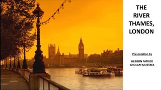
River Thames, London
•Descargar como PPTX, PDF•
1 recomendación•346 vistas

This Presentation describe the understanding of living aspect along the river.

Recomendados
Más contenido relacionado
La actualidad más candente
La actualidad más candente (20)
Similar a River Thames, London
Similar a River Thames, London (20)
Último
Último (20)
River Thames, London
- 2. CONTEXT • Introduction to River Thames • History of river Thames • Understanding of Map • Sections of River Thames and its bridges • Sections of Retaining wall of River Thames • Historical Building & Monument near River Thames • Contamination in River • Flood risk management • Flooding Barriers combats • Highway of attraction • The River As Tourist Space And Visitor Experience • Thames valley corridor • Uses of thames river • Apartment
- 4. NIGHT VIEW OF RIVER THAMES
- 6. ENGLAND MAP WITH THAMES RIVER MARKATION
- 9. ROAD MAP
- 10. History of The River Thames. The river has been an important trade and transport route since prehistoric times. London's fame and fortune is due its river. All through the Middle Ages the Thames was one of London's main highways. Barges and river boats brought fish, wood and wool to the City, while hundreds of watermen in small rowing boats ferried people up and down. By the 1700s, trading ships were arriving carrying all kinds of goods for sale in the City. Tea, silk and a fortune of spices came from the East. Sugar was brought from the Caribbean, timber from Norway and iron ore from Sweden. The Thames was so busy that traffic on the river could hardly move. Sometimes, dozens of ships queued for days along the banks, waiting to get to a dock to unload.
- 11. Historical Towns The freshwater River Thames winds its way across the counties of Wiltshire, Gloucestershire, Oxfordshire, Berkshire, Buckinghamshire and Surrey. From its source in Cricklade to the outskirts of London, there are so many towns to visit.
- 12. About the river... It’s part of the longest river in England, it has 45 locks, is home to over 25 species of fish, boasts three areas of outstanding natural beauty and it’s the only river in Europe to have a national trail follow its entire length. This is the rural River Thames Starting as a small trickle in the Cotswolds the River Thames travels over 210 miles through the heart of some of England’s most picturesque towns, right into the centre of London and eventually, out into the North Sea.
- 13. • River Thames is in England, and the London bridge covers the River Thames. • Longitude 0° 37' 31.6351" • Latitude N 51° 30' 10.197“ • The length of River Thames is 215 miles long. • The width of River Thames is 18 meters near the rise or start. • The River Thames increases the further downstream you go. The depth of River Thames is always changing. • The River Thames was formed between 140 and 170 million years ago. • Then most of England was covered by sea. • It was formed through southern England.
- 14. SPECIES IN RIVER SLOPE OF RIVER
- 16. Facts About The River Thames... •The River Thames may take its name from the Sanskrit Tamas meaning “dark” as its waters are often dark and cloudy; another idea is that it is named after the Roman Tam meaning “wide” and Isis meaning water. •The River Thames is 346 km long. •Long ago, before Britain was separated from continental Europe, the Thames was a tributary of the Rhine. The English Channel was formed about 7,000 years ago at the end of the last Ice Age. •There are 45 Locks on the non-tidal River Thames •Buscot Lock, just east of Lechlade, is the smallest lock on the river. •Pangbourne, where the river Pang flows into the River Thames, is famous as the home of Kenneth Grahame, author of The Wind in the Willows and also as the place where Jerome K Jerome’s three men in a boat finish their journey at the Swan Inn. •The non-tidal River Thames is home to over 25 species of course fish. •The Thames Path follows the river for 296km (184 miles) from its source, making it the longest riverside walk in Europe.
- 17. WHERE DOES THE RIVER THAMES START AND FINISH, HOW MANY MILES LONG IS IT AND WHAT IS THE FLOW RATE? The River Thames is 215 miles long (346 km). That’s quite a long river, as 215 miles is roughly the distance between London and Middlesborough as the crow flies. The Thames begins in Gloucestershire at Trewsbury Mead (near Cheltenham) and ends between Whitstable, Kent, and Foulness Point, Essex. The non-tidal Thames (the distance from the source of the river near Cheltenham, to Teddington in west London) measures 147 miles (237 km). A total of 104 bridges cross over the Thames, 75 bridges over the non-tidal Thames, and 29 bridges cross over the tidal Thames between Teddington and the sea. The river’s depth varies wildly but at London Bridge it’s 1.8m. It’s recorded as 1.9m at Westminster Bridge. Throughout history, it’s been so cold that the Thames has frozen solid, allowing fairs to be held on its surface. The last of these fairs happened in February 1814. At its widest, right at the mouth of the river, the Thames measures 18 miles across and it’s just 18 meters at its narrowest in Lechlade. The speed of the river’s flow picks up the further towards the sea you go, and varies each day, though boaters can keep tabs on it here. At Buscot 799 million liters/day (176 million gallons/day) pass, at Reading 3,594 million liters day pass (790 million gallons/day) and at Kingston 5,696 million liters /day (1,253 million gallons/d) pass by.
- 19. Section of Thames River Source https://www.google.com/url?sa=i&url=https%3A%2F%2Fthames.me.uk%2Fs00035.htm&psig=AOvVaw339wreGnXzvTYkN4z3kD0Q&ust=1599240815405000&source=ima ges&cd=vfe&ved=0CAIQjRxqFwoTCNjVscLCzesCFQAAAAAdAAAAABAd
- 20. Section of Thames River
- 24. Section of Tunnels under City & Thames River
- 25. Section of Tunnels under City & Thames River
- 26. Section of Tunnels under City & Thames River
- 27. SEWERAGE SYSTEM
- 28. Source https://www.orientalsheetpiling.com/wp-content/uploads/2017/11/river-cross-section-and-flood-retaining-wall.jpg Section of River Retaining Wall
- 29. Section of River Retaining Wall
- 31. MAP
- 34. TRAVEL ACROSS LONDON BY RIVER
- 36. HISTORICAL BUILDING & MONUMENT NEAR RIVER THAMES 1. Hampton Court Palace 2. Tate Britain & Tate Modern 3. The Palace of Westminster. 4. The London Eye 5. HMS Belfast + Tower Bridge 6. Tower of London 7. Greenwich Park Source https://www.orientalsheetpiling.com/wp-content/uploads/2017/11/river-cross-section-and-flood-retaining-wall.jpg
- 37. Source https://www.planetware.com/london/east-molesey-hampton-court-palace-eng-sr-hcp.htm#ENG3 Hampton Court Palace Historic Hampton Court Palace-one of England's top tourist attractions-lies southwest of London on the north bank of the River Thames. Built in 1514 as a private residence for Cardinal Wolsey, the palace was later presented to Henry VIII to secure the King's favor. The palace was opened to the public during Queen Victoria's reign, and although no longer a royal residence, parts of it are occupied by individuals granted "grace and favor" apartments by the monarch..
- 39. Source https://www.planetware.com/london/east-molesey-hampton-court-palace-eng-sr-hcp.htm#ENG3 Hampton Court Palace Pictures 1. Henry VIII's Apartments and the Great Hall 2. William III's State Apartments
- 40. Source https://www.planetware.com/london/east-molesey-hampton-court-palace-eng-sr-hcp.htm#ENG3 Hampton Court Palace Pictures 3. The Chapel Royal 4. The Tudor Kitchens and Cellars
- 41. Source https://www.planetware.com/tourist-attractions-/london-eng-l-lon.htm Tate Britain & Tate Modern Tate is an institution that houses, in a network of four art museums, the United Kingdom's national collection of British art, and international modern and contemporary art. It is not a government institution, but its main sponsor is the UK Department for Digital, Culture, Media and Sport.
- 42. Source https://www.guidelondon.org.uk/blog/around-london/9-major-sites-along-londons-river-thames/ Tate Britain & Tate Modern
- 43. Source https://www.planetware.com/tourist-attractions-/london-eng-l-lon.htm Westminster Abbey Westminster Abbey, formally titled the Collegiate Church of Saint Peter at Westminster, is a large, mainly Gothic abbey church in the City of Westminster, London, England, just to the west of the Palace of Westminster.
- 46. Source https://www.guidelondon.org.uk/blog/around-london/9-major-sites-along-londons-river-thames/ London Eye The London Eye, or the Millennium Wheel, is a cantilevered observation wheel on the South Bank of the River Thames in London. It is Europe's tallest cantilevered observation wheel,[14] and is the most popular paid tourist attraction in the United Kingdom with over 3 million visitors annually,[15] and has made many appearances in popular culture.
- 48. Source https://www.guidelondon.org.uk/blog/around-london/9-major-sites-along-londons-river-thames/ HMS Belfast + Tower Bridge Built by Messrs Harland & Wolff in 1936, HMS Belfast was launched by Anne Chamberlain, wife of the then Prime Minister Neville Chamberlain, on St Patrick's Day in 1938. After fitting out and builder's trials, HMS Belfast was commissioned into the Royal Navy on 5 August 1939 under the command of Captain G A Scott DSO RN.
- 49. Source https://www.guidelondon.org.uk/blog/around-london/9-major-sites-along-londons-river-thames/ HMS Belfast + Tower Bridge
- 50. Source https://www.guidelondon.org.uk/blog/around-london/9-major-sites-along-londons-river-thames/ Tower of London The Tower of London, officially Her Majesty's Royal Palace and Fortress of the Tower of London, is a historic castle on the north bank of the River Thames in central London.
- 53. Source https://www.guidelondon.org.uk/blog/around-london/9-major-sites-along-londons-river-thames/ Greenwich Park Greenwich Park is a former hunting park in Greenwich and one of the largest single green spaces in south-east London. One of the Royal Parks of London, and the first to be enclosed, it covers 74 hectares, and is part of the Greenwich World Heritage Site.
- 56. LONDON SKYLINE LANDSCAPE POLICIES 1. London’s identity is a primary consideration. It must be allowed to evolve but changes require a perspective which includes the past and relates to a future vision. In the 1930s, Rasmussen wrote a famous book on London the unique city and Abercrombie. used diagrams to show the different characteristics of English cities, continental cities, garden cities and Corbusier’s City of the Future, with apartment blocks in a park-like setting. London should take a view on its future form. 2. Suitable areas for high rise development, and those parts of London in need of protection from domination from high buildings, should be identified and mapped as part of a London Roofscape Plan. The West End is generally low rise and human in scale, with squares and areas of parkland secluded from the surrounding metropolis. This contrasts with the dramatic high rise areas of the City and Docklands. Maximum heights should be controlled to conserve this distinction. 3. The Royal Parks, and other parks, should be protected from enclosure by high rise buildings. 4. High buildings and skyline policies should be integrated with wider landscape policies for pedestrian circulation, scenic composition, the social use of outdoor space and the use of vegetation on roofs, on walls and at street level. 5. The GLA should commission a digital model of the existing city and of projects which have been granted planning permission. New proposals at the pre-planning stage should be placed in the model and used to generate accurate eye-level perspectives from all surrounding viewpoints. The cost of the models should fall upon the developers of proposed high rise buildings.
- 57. 6. London also needs local skyline studies for supplementary planning guidance and for the preparation of site-specific planning and development briefs. Special attention should be given to the social, economic and visual impact of high buildings on adjoining streets and the impact on the River Thames. All Boroughs should include metropolis wide effects in their skyline studies, including impacts on key views in other Boroughs. 7. Protection of views of St Paul’s Cathedral from the south-west (St Paul’s Heights) should be maintained, 8. Protection for views of and from London’s World Heritage Sites, as required by UNESCO. These sites are: • The Tower of London, • The Palace of Westminster, and Westminster Abbey • The Royal Botanic Gardens, Kew and • Maritime Greenwich. 8. Existing buffer zones for World Heritage Sites should be extended. The buffer for the Tower of London should be extended to the east and to the south of the river. It the City it should be reinforced. The proposed buffer zones for the Westminster World Heritage site should similarly be enforced extended northwards and southwards along the south bank of the river (in Southwark and Lambeth). In the case of Westminster ICOMOS-UK have recently prepared preliminary viewing corridors of key views.
- 58. 9. London’s floorspace requirements can be met without high rise buildings5. But a continuing demand for high buildings is expected - for branding, prestige, and other reasons. Positive and negative impacts of high buildings on the public landscape should be assessed by neutral assessors and taken into account during the planning and design process. 10. High rise should be composed on an all-London basis. Both residential and commercial towers should be scenically composed. The cluster at Canary Wharf, for example, is better than the ‘pepper- potting’ of tall buildings in other parts of London, and views of The Shard benefit from being 250m from the Thames foreshore and being removed from any key Inner London picturesque views.
- 59. Conclusion An all-London skyline policy integrated with an urban landscape policy is an urgent priority and could begin with a Thames Policy Area study. The study should deal with the issues raised above and with the issues illustrated and questioned below. London’s skyline policy should draw up, and integrate, existing policies issued by the GLA, the Boroughs, English Heritage and other bodies. References: 1. Quoted in the Dictionary of National Biography (from Egmont Diary, 2.138) 2. Rasmussen, Steen Eiler, London, the Unique City (1937) 3. Abercrombie, Patrick Town and country planning (1933, 1959) 4. Corbusier, Le, La Ville Radieuse (The Radiant City) (1935) 5 Tall buildings: Report and proceedings of the House of Commons Transport, Local Government and the Regions Committee. Sixteenth report of Session 2001-02 (The Stationery Office:2002)
- 60. THE RIVER AS TOURIST SPACE AND VISITOR EXPERIENCE • The Thames has been a recreational resource for centuries, even if this role was undermined at the height of the city’s industrialization. With the global development of urban tourism in recent decades, and by virtue of the plethora of tourist attractions and sights, the river has become a thriving tourist space. This is immediately evident when standing on any of the central London bridges and surveying the river craft which pass by. Boats and vessels now predominantly carry sightseers and river piers are cluttered with tourist infrastructure. • A walk across these bridges is inevitably interrupted by visitors posing for photographs. Pedestrianized riverside promenades (especially along the South Bank) are almost permanently inhabited by buskers, performers and pop-up retailers.
- 61. • Walking • Boating • Canoeing • Rowing • Sailing • Cycling • Fishing • Visiting a Riverside Restaurant • Sitting in a Riverside Pub Things To Do At The River...
- 62. A HIGHWAY OF ATTRACTIONS • A remarkable number of London’s major tourist attractions are either on or just beyond the river. The list of the ten most visited UK attractions in 2017, produced by the Association of Leading Visitor Attractions (all of which are in London) reveals that five are located on the city’s river banks (indicated in Table 8.1 in italics). Two further riverside attractions (Kew Gardens, Tate Britain) were the 14th and 15th most visited in the UK in 2017.
- 63. The Port of London Authority estimated that over £2 billion of GDP was generated by tourism in 2015 in the wards immediately adjacent to the river (Port of London Authority 2016) and that there were 23.4 million visitor trips to attractions beside the Thames in 2015, of which 4.7 million had a direct maritime connection. This reaffirms the significance of the River Thames and riparian territory in London’s visitor economy. London’s four World Heritage Sites (the Royal Botanic Gardens in Kew, the Palace of Westminster and the Abbey, the Tower of London and Maritime Greenwich) all flank the riverside and are symbolic of the role the river played in establishing London and Britain’s maritime, scientific and global supremacy during the Empire period. As the Mayor of London wrote in 2013 The river’s vital role as both an artery for transporting people through the heart of London and as a playground for people to explore the wonders of the city are on show for the world to see. A trip along the Thames reveals 2,000 years of riparian history; from the Roman walls at Tower Hill, and the Victorian wharves and warehouses to the soaring peak of The Shard – providing a stunning vista of London’s past and present. (Mayor of London, 2013)
- 65. INTRODUCTION 1. London has always viewed the Thames Valley Corridor as its most important natural, cultural, recreational and aesthetic resource. It has been called the gem of South-western Ontario with its multi-functional role that has formed London’s history and crafted its unique identity. It is a place of stories and a place of memories. It is a place of natural heritage and beauty, of recreation and leisure, of tourism and of servicing the City. It is many things to many people 2. The goal of the Thames Valley Corridor Plan (TVCP) is to protect and enhance the environmental features of the River Valley while accommodating the multi-functional role of the river valley system over the long-term. The Plan represents an integrated product that illustrates, through a series of maps and supporting documentation, how the protection and enhancements of the valley corridor will be realized through: • natural heritage protection, including species-at-risk • new park pathways to complete system gaps, and improved trails • focused recreational activity areas and facilities along the Valley • open space areas for stewardship initiatives and ecological restoration • park enhancements at the Forks that support Downtown initiatives • land use guidelines and related polices • built and natural heritage interpretation possibilities • adjacent urban redevelopment opportunities and constraints • key land acquisition recommendations 3. The Plan further provides a number of recommendations and action items to achieve this goal. The recommendations and action items have been categorized into 4 key theme areas; • Natural Heritage, Stewardship, and Protection; • Celebration, Recreation, Leisure and Tourism; • Land Use Planning and Management; and • The Working River.
- 67. NATURAL HERITAGE, STEWARDSHIP AND PROTECTION
- 68. CELEBRATION, RECREATION, LEISURE AND TOURISM
- 69. LAND USE PLANNING AND MANAGEMENT
- 71. AREAS OF SPECIAL INTEREST
- 72. USES OF RIVER THAMES
- 74. Source A cost-effectiveness analysis of water security and water quality: impacts of climate and land-use change on the River Thames system The river is eutrophic with significant algal blooms (kaali) ( with phosphorus assumed to be the primary chemical indicator of ecosystem health. In the Thames Basin, phosphorus is available from point sources such as wastewater treatment plants and from diffuse sources such as agriculture THAMES RIVER IS ILL…🤐
- 75. The river is eutrophic with significant algal blooms with phosphorus assumed to be the primary chemical indicator of ecosystem health. In the Thames Basin, phosphorus is available from point sources such as wastewater treatment plants and from diffuse sources such as agriculture In the UK, a wide range of measures have been proposed and evaluated to achieve the required status .Many of these measures, such as source control of pollutants, enhanced effluent treatment or changed agricultural practices, are expensive and require cooperation from a wide range of stakeholders. Phosphorus is considered to be the key parameter controlling ecology and hence eutrophic status in the UK and worldwide , although Barker et al. have raised the issue of nitrogen being of concern, especially in terms of biodiversity. Bowes et al. have identified water residence time as a factor controlling algal growth, but there are many other factors such as flow, light intensity, suspended solids, nutrient concentrations that affect algal growth as well as shading by riparian vegetation Source A cost-effectiveness analysis of water security and water quality: impacts of climate and land-use change on the River Thames system A COST-EFFECTIVENESS ANALYSIS OF WATER SECURITY AND WATER QUALITY: IMPACTS OF CLIMATE AND LAND- USE CHANGE ON THE RIVER THAMES SYSTEM
- 76. ONE OF THE MAJOR RESOURCES PROVIDED BY THE Thames is the water distributed as drinking water by Thames Water, whose area of responsibility covers the length of the River Thames. The Thames Water Ring Main is the main distribution mechanism for water in London, with one major loop linking the Hampton, Walton, Ashford and Kempton Park Water Treatment Works with central London. In THE PAST, COMMERCIAL ACTIVITIES ON THE THAMES included fishing (particularly eel trapping), coppicing willows and osiers which provided wood, and the operation of watermills for flour and paper production and metal beating. These activities have disappeared. A screw turbine hydro-electric plant at Romney Lock to power Windsor Castle using two Archimedes' screws was opened in 2013 by the Queen.[56] This followed the first installation of such a screw at Mapledurham Watermill in 2011. THE THAMES IS POPULAR FOR A wide variety of riverside housing, including high-rise flats in central London and chalets on the banks and islands upstream. Some people live in houseboats, typically around Brentford and Tagg's Island. Source https://en.wikipedia.org/wiki/River_Thames
- 77. Substantial growth is planned through ‘Thames Gateway’, a regeneration initiative of the United Kingdom government. These new developments will fundamentally change the developed footprint in the Thames Estuary flood-plain, and will be in place for at least the next 100 years. This presents a challenge of planning future defence against a background of uncertainty over climate and other environmental change, while ensuring that correct decisions are made concerning the nature and location of new building in the tidal flood- plain. Through its ‘Thames Estuary 2100’ project, the Environment Agency is developing a long- term strategy for flood risk management in the estuary. Implementation of major construction works on the River Thames could commence from around 2015. Alternatively, it may be decided that minimum works are undertaken to provide security and major investment is delayed until uncertainties over climate change have abated. Whatever long-term option is chosen, this must be preceded by a period of collaboration with the Thames Gateway developments to ensure appropriate and sustainable flood defenses are incorporated in new riverside construction. SOLUTION FOR FLOOD RISK MANAGEMENT Source Flood risk management in the Thames Estuary looking ahead 100 years Sarah Lavery and Bill Donovan https://doi.org/10.1098/rsta.2005.1579
- 78. The River Thames tidal defenses have provided protection against the increasing threat of tidal flooding from the North Sea for more than 2000 years. The flood of 1953 was the catalyst for the construction of the current system of River Thames tidal defenses, which includes the Thames Barrier, and has provided one of the best standards of flood defense in the UK for over 20 years. Flood Risk Management In The Thames Estuary Looking Ahead 100 Years Source Flood risk management in the Thames Estuary looking ahead 100 years Sarah Lavery and Bill Donovan https://doi.org/10.1098/rsta.2005.1579
- 79. FLOOD BARRIER COMBATS The flooding is caused by the reversal of water flow in the River Thames when levels rise in the North Sea Flood control downstream of London: the Thames Barrier. (Source: Encyclopedia Britannica, Inc.) The average flow at the upper limit of the tideway, at Teddington, is 1,856 cubic feet (53 cubic meters) per second, rising to 4,640 cubic feet (130 cubic meters) per second after winter rain. In extreme floods (e.g., March 1947) the discharge at Teddington Weir may be as much as 20,900 cubic feet (590 cubic meters) per second. Reputedly, an average of 31,310 cubic feet (887 cubic meters) per second passed over it one day after heavy storms in 1894. The river in spate can upset tidal flows for some distance below Teddington, overpowering the incoming tide and causing the stream to run seaward continuously for days on end. Conversely, high spring tides can overtop the weir and affect the river flow as far as 2 miles (3.2 km) upstream of Teddington. The catastrophic potential of tidal surges for London’s underground infrastructure, buildings, and population prompted the construction of the Thames Barrier at Silvertown (completed 1982) and extensive complementary flood defenses along the entire tideway.
- 80. The Thames Barrier consists of 10 movable gates separated by 9 piers. Each gate has a curved face that lies in a recessed chamber in the riverbed when the barrier is fully open. When the signal is given, the gates rotate 90° to a closed position, blocking the path of the surge tide in less than 30 minutes. Source: Encyclopædia Britannica, Inc. Get exclusive access to content from our 1768 First Edition with your subscription.
- 81. APARTMENTS BUILDING NEAR RIVER THAMES • Riverside apartments • Admiralty building • Perpetual house ‘the Royal Apartment’ • Elder House • Clarendon apartments- Docklands Canary Wharf • Granite Apartments • Queenshurst Square • Clarendon Serviced Apartments- Steward Street • Clarendon Serviced Apartments- serviced Apartment in artillery lane, London • Cardamom Building • Marina Place • The Heart Apartments • Roomspace Serviced Apartment- River House • 3 Lotus Park • Parliament View apartments • Urban Stay Shard View Serviced Apartments Monument • Hill View Apartments • Notting Hill Apartments Ltd. • Verona Apartments
- 82. WHITE HALL PLACE
- 83. Route map:
- 84. Satellite view:
- 88. VIEWS :
- 90. TWO BED PLAN:
- 91. STUDIO:
- 92. AVAILABILITY
- 93. INTERIOR VIEWS:
- 96. THE ADLEN SOUTH HILLS
- 97. SPARKING SWIMMING POOL RESIDENT PLAY GROUND EVENING VIEW TOP VIEW OF POOLGYM
- 98. PLANS: • ONE BED
- 99. PLAN
- 100. 2BED
- 101. PLAN
- 102. 3 BED
- 103. PLAN
- 104. BASMENT APPARTMENT 2 BED
- 107. THANK YOU