Soil nitrous oxide and methane emissions are low across land use types in Kenya
•
0 recomendaciones•67 vistas

Poster prepared by Lutz Merbold, Mazingira Centre, ILRI, for the Virtual Livestock CRP Planning Meeting, 8-17 June 2020
Recomendados

Recomendados
Más contenido relacionado
La actualidad más candente
La actualidad más candente (20)
Similar a Soil nitrous oxide and methane emissions are low across land use types in Kenya
Similar a Soil nitrous oxide and methane emissions are low across land use types in Kenya (20)
Más de ILRI
Más de ILRI (20)
Último
Último (20)
Soil nitrous oxide and methane emissions are low across land use types in Kenya
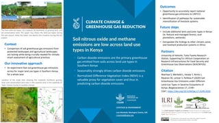
- 1. § Carbon dioxide emissions are the primary greenhouse gas emitted from soils across land use types in Southern Kenya § Seasonality strongly drives carbon dioxide emissions § Normalized Difference Vegetation Index (NDVI) is a valuable proxy for vegetation cover and thus in predicting carbon dioxide emissions Soil nitrous oxide and methane emissions are low across land use types in Kenya Partners University of Helsinki, Taita-Taveta Research Station, Supporting EU–African Cooperation on Research Infrastructures for Food Security and Greenhouse Gas Observations (SEACRIFOG) Outcomes • Opportunity to accurately report national greenhouse gas emissions to UNFCCC • Identification of pathways for sustainable intensification of livestock systemsCLIMATE CHANGE & GREENHOUSE GAS REDUCTION The CGIAR Research Program on Livestock thanks all donors & organizations which globally support its work through their contributions to the CGIAR Trust Fund. cgiar.org/funders This document is licensed for use under the Creative Commons Attribution 4.0 International Licence. June 2020 Context • Comparison of soil greenhouse gas emissions from protected landscapes and agricultural landscapes are lacking while being crucially needed for climate- smart assessment of agricultural practices Our innovative approach • An experiment that soil greenhouse gas emissions across for major land use types in Southern Kenya for a whole year Future steps • Include additional land use/cover types in Kenya (ie. Natural and managed forests, sisal plantations, wetlands) • Extrapolate the findings to other climatic zones and livestock production systems in Africa Lutz Merbold, Mazingira Centre, ILRI l.merbold@cgiar.org LIVESTOCK & ENVIRONMENT Citation Wachiye S, Merbold L, Vesala T, Rinne J, Räsänen M, Leitner S, Pellikka P (2020) Soil Greenhouse Gas Emissions under Different Land-Use Types in Savanna Ecosystems of Kenya. Biogeosciences 17, 2149– 2167, https://doi.org/10.5194/bg-17-2149-2020 Location of the study sites showing the cropland, bushland, grazing land, and conservation land sites in the savanna area in the lowlands of Taita–Taveta County in southern Kenya. The four land-use types: (a) cropland, (b) bushland, (c) grazing land, and (d) conservation land. The upper row shows the land-use types during the wet season, while the lower row depicts the situation during the dry season.