
Recomendados
Recomendados
Más contenido relacionado
Destacado
Similar a ER&SD "skeleton" presentation
Similar a ER&SD "skeleton" presentation (20)
Último
Último (20)
ER&SD "skeleton" presentation
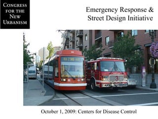
- 1. Emergency Response & Street Design Initiative October 1, 2009: Centers for Disease Control
- 2. Traffic related issues; Fire Related Issues;
- 4. 2.4 7.6 (per 500’ block) Narrower streets are safer streets, but Fire operations must be accommodated
- 8. Comparing Street Connectivity An Existing Chico Subdivision
- 9. Comparing Street Connectivity Proposed Plan
- 10. Long, slow routes Short, direct routes
- 11. Households per Fire Station
- 12. Annualized Per-Capita Life Cycle Costs (based on 2-apparatus station)
- 13. Average Citywide Response Time and Connectivity Ratio
- 15. Response time = average speed * response distance
- 23. 2.4 7.6 (per 500’ block)
Notas del editor
- Background: US EPA grant RFP in 2007. CNU applied, won because it can leverage membership across disciplines: planning, engineering, architecture, and work with fire service professionals. Cooperative venture from the beginning: fire marshals in on the organizational conference calls in Fall 2007: Carl Wren (Austin, TX), Rick Merck (Montgomery County, MD), helped identify other fire marshals, and ultimately wrote the code language that CNU submitted this June to the Intl. Code Council. April 2008 Workshop in Austin, TX, brought 24 professionals together; found common ground in realization that New Urbanists and firefighters see this as a public safety issue. October 2008 workshop in Denver, CO, focused on national fire codes and how to amend them. Transportation Summit 2008 in Charlotte, NC, developed language for Section 503.2 of the International Fire Code, and the need for a new, optional appendix to the code. Code amendment language developed from November 2008 to June 1, 2009, when it was submitted to the ICC.
- Street width is a clear public safety issue. Graph in upper right shows that the numbers of traffic-related injuries and fatalities far outpace directly fire-related injuries and fatalities. Graph in upper left shows that the severity of pedestrian injuries increases as traffic speeds increase: a pedestrian struck at 36 mph will die. And wider streets lead to faster speeds. But firefighters’ space needs are legitimate. Photos at bottom show the access problems when vehicles are parked too close to the intersection, and the space needs for ladder truck stabilizers, or “jacks.” Smart street design and parking restrictions must take these needs into account.
- Graph on the left, developed in the Smith-Appleyard study from 1981, shows in the dotted line that the wider your street, the faster its traffic. It also demonstrates that the distance between building facades, or structures, matters, too. The solid line shows that traffic speed increases when buildings or structures are further apart, too. But again, operating space must be considered. Hoses with hundreds of gallons of water flowing through them need room, and firefighters need room to quickly remove equipment like ladders, oxygen tanks, etc.
- The fire service’s adherence to a 4- to 6-minute response time is not arbitrary; brain damage sets in within 8-10 minutes of oxygen deprivation, and brain death is all but certain after 10-11 minutes. The fire service’s adherence to sprinkler systems is not arbitrary, either. Fires can reach flashover -- the point at which they become uncontrollable -- in just 8 minutes. The funnel shows this progression. The horizontal bar at the bottom shows how many minutes pass before the fire department is alerted to a fire. And the run time from station to fire. And the time needed to assess the situation, break out equipment, and begin fighting the fire. When residential sprinklers are present, they activate at Minute 1; commercial sprinklers activate at Minute 4. They retard the fire’s growth, keeping it from flashing over. Many fire marshals have told us that they are much more amenable to narrower streets when structures are equipped with sprinkler systems.
- Connectivity is critical to reducing emergency response times. These isolated, disconnected developments exemplify James Howard Kunstler’s “Geography of Nowhere,” because they’re everywhere, and everywhere the same. They force firefighters to drive farther from the station to an incident, increasing response times. Moreover, what happens to the folks living in the subdivision at right, if the only access intersection is blocked?
- Traffic in Small Cities Planners' Institute, San Diego, 21 March 2003 Sargent Town Planning The traditional street grid, seen here in a Maryland city, doesn’t have that problem because its streets are connected. If one block or intersection is blocked, firefighters can simply drive around the obstruction. Response times are reduced because firefighters don’t have to drive as far from the station.
- Another example of how connectivity improves response times is seen in Chico, CA. Compare the existing subdivision, left, with a proposed neighborhood off Esplanade, north of East Ave., at right.
- The city of Charlotte, NC, studied connectivity and emergency response time, releasing its results at CNU’s Transportation Summit 2008. The city showed that greater connectivity allows a single fire station to cover more addresses -- stations in the oldest neighborhoods, the ones with greatest connectivity, cover 2 to 3 times the number of households than stations in the newest subdivisions with the least connectivity. Raleigh, NC, found this to be true, too. Its study, cited in “Planning for Street Connectivity: Getting from Here to There,” looked at a 1.5-mile radius from fire stations and stated that stations in the most connected neighborhoods covered 3 times the number of addresses than stations in the least connected neighborhoods.
- Moreover, Charlotte found that connectivity is more cost-effective, since a station’s per capita costs are spread amongst a larger group.
- And Charlotte found that better connectivity leads to better response times. Since the city’s street connectivity ordinance took effect in October 2001, citywide response time has dropped by 30 seconds.
- Problems with street design and modern fire equipment can be plainly seen in this scene from New York City.
- Poorly designed intersections that don’t have good turning radii -- like this neighborhood in Austin, TX, force the truck to back up and make a turn in two moves instead of one.
- The same neighborhood in Austin plainly shows the operational difficulties that can arise from streets that are too narrow.
- When hoses are filled with hundreds of gallons of water, they need room; they will not bend or curve easily.