
Recomendados
Más contenido relacionado
La actualidad más candente
La actualidad más candente (20)
Destacado
Similar a Final Report (Intersection Improvement Project)
Similar a Final Report (Intersection Improvement Project) (20)
Más de Josia Tannos, EIT
Más de Josia Tannos, EIT (8)
Final Report (Intersection Improvement Project)
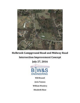
- 1. Holbrook Campground Road and Midway Road Intersection Improvement Concept July 27, 2016 Will Brazzil Josia Tannos William Woolery Elizabeth Shaw
- 2. BTW&S Engineering 790 Atlantic Drive NW Atlanta, Georgia, 30332 July 27, 2016 Geoffrey E. Morton, P.E., Director Cherokee County Public Works Agency 1130 Bluffs Parkway Canton, Georgia 30114 Dear Mr. Morton: Please find enclosed a copy of our intersection improvement concept design alternatives report for the intersection of Holbrook Campground Road and Midway Road. The report includes two main alternatives: A roundabout and a rebuilt two way stop controlled intersection in a ‘T’ configuration. The report includes all relevant procedures, drawings, data analysis and a cost estimate for each alternative. The overview of the existing conditions and alternative options are all outlined in the report. Evaluations were make based on safety, traffic, geometry and other critical criterion which affect the intersection. The report discusses the reasoning and referenced design standards which drove the design process. Detailed calculations and a complete concept design plan are enclosed. The recommended alternative design, the roundabout intersection configuration, will improve traffic flow, ease the navigability of the intersection, and increase safety at the intersection of Holbrook Campground Rd and Midway Rd. We at BTW&S Engineering would like to thank you for the opportunity to assist in the improvement of this intersection. If you have any questions please do not hesitate to contact us by telephone at 936.827.5948 or via email at wbrazzil3@gatech.edu. Sincerely, Will Brazzil Project Manager
- 3. Table of Contents: Executive Summery Introduction………………………………………………….……………………………..……..….1 Location Scope Existing Conditions Design Alternatives………………………….………………………………………..…...………6 T Intersection Design Realignment Geometric Design Roundabout Geometric Design Reasoning Traffic Data………………..…………………………………………..…………………………....11 Roundabout Analysis Tool and HCS Utility relocation……………………………………………………………………………….…14 Water Gas Power Cable Telephone Drainage…………………………………….………………………………………………………...15 Cost Estimation………………………………………..………………………………………..…17
- 4. Pavement Right-Of-Way Access Management Utility Relocation Report 1: Roundabout Report 2: Rebuilt Stop Controlled Intersection Challenges and Future Recommendations…………………………......……………22 Conclusion ………………………………………………………………………….....……………23 References...………………………………………………………………………….....………..…25 Appendices………………………………………………………………………………….……….26 A - Intersection Accidents Report B - Traffic Data AM Peak PM Peak Geocounts Traffic for Georgia DOT C - Roundabout Analysis Tool 2016 AM Peak Hour 2016 PM Peak Hour 2036 AM Peak Hour 2036 PM Peak Hour Roundabout Capacity Curve D - HCS Analysis Existing Intersection 2016 AM Peak Hour Existing Intersection 2036 AM Peak Hour Existing Intersection 2016 PM Peak Hour Existing Intersection 2036 PM Peak Hour
- 5. T-Intersection 2016 AM Peak Hour T-Intersection 2036 AM Peak Hour T-Intersection 2016 PM Peak Hour T-Intersection 2036 PM Peak Hour Roundabout 2016 AM Peak Hour Roundabout 2036 AM Peak Hour Roundabout 2016 PM Peak Hour Roundabout 2036 PM Peak Hour E – Sight Distance Analysis F – Plans T-Intersection Existing vs Proposed Roundabout Existing vs Proposed T-Intersection Right-of-Way Roundabout Right-of-Way T-Intersection Signing and Marking Roundabout Signing and Marking T-Intersection Drainage Roundabout Drainage T-Intersection Driveways Roundabout Driveways G - Traffic Diagrams T-Intersection 2016 AM Peak Hour T-Intersection 2016 PM Peak Hour T-Intersection 2036 AM Peak Hour T-Intersection 2036 PM Peak Hour Roundabout 2016 AM Peak Hour
- 6. Roundabout 2016 PM Peak Hour Roundabout 2036 AM Peak Hour Roundabout 2036 PM Peak Hour H - Utilities I - Typical Sections
- 7. Executive Summary: The objective of this project is to deliver multiple design concept alternatives for the improvement of the Holbrook Campground Road and Midway Road intersection in Cherokee County, Georgia. This report, completed by BTW&S Engineering for the Cherokee County Public Works Agency, takes into account many factors including safety and level of service to determine the most effective alternative. The existing intersection includes a free-flowing Holbrook Campground and a stop- controlled Midway Road intersecting in a "Y" shape. To alleviate sight distance and safety issues, it was decided that Midway Road would be realigned to create a more perpendicular intersection. The ideal location was chosen atop the highest point in the area, to ensure appropriate sight distance at the intersection. Stopping sight distance is also an issue, particularly with stopped vehicles on Midway Road looking left. This sight distance was calculated and was found to be insufficient. Traffic counts were taken in the field to determine morning peak, 7:15-8:15 AM, and afternoon peak, 5-6 PM. This intersection has a high accident rate with 24 collisions reported in the past three years. Due to the safety and sight distance issues two alternatives were proposed. The first alternative is to realign the intersection to meet perpendicularly and to have designated left and right turn lanes. This would not improve traffic conditions of level of service for the westbound, Midway Road, approach. This alternative would cost in total $543,747. The second alternative is a single lane roundabout. Using the Georgia Department of Transportation's (GDOT) roundabout analysis tool, this alternative yields a better level of service than the first alternative. The estimated cost of the roundabout $513,585. The second alternative was chosen, and an in depth report was written for the single lane roundabout. The proposed design meets all the GDOT Standards as well as the MUTCD. Factors such as existing conditions, sight distance, speed control, congestion, drainage, cost, and safety are considered during the design process. The proposed design has an inscribed circle of 90 feet. This alternative was also considered preferred because of the abundant right-of-way. Roundabouts are good for locations with a history of accidents such as this intersection having 24 accidents in the past 3 years. Roundabouts are good for intersections with irregular approach geometry such as this intersection. This alternative can moderate the traffic speeds on Midway Road and Holbrook Campground Road and minimize queuing at the approaches. The three main utilities of water, gas and power need to be taken into account when planning a project like this. A lump sum estimate was provide for relocation of the power
- 8. utilities, which run through overhead lines and a buried cable in the area. Water and natural gas lines run 10 to 12 feet from the edge of the roadway, and the operators prefer to have their own right-of-way for maintenance purposes. This report details plans for rerouting these lines around the proposed improvements where necessary. Cable and telephone utilities are also taken into account. BTW&S Engineering has completed concept design plans of the roundabout and T- intersection alternatives and provided a cost estimate for the implementation of the proposed plan. The design improves sight distance, safety and capacity of the intersection.
- 9. P a g e | 1 Introduction: Location: The project is located at the intersection of Holbrook Campground Rd and Midway Rd in Alpharetta, Georgia. The location with respect to the Metro Atlanta area is show below in Figure 1 and the detailed intersection aerial photography is shown blow in Figure 2. Images are from Google Maps. Figure 1: Location of Holbrook Campground Rd and Midway Rd
- 10. P a g e | 2 Figure 2: Arial Photography of the Intersection The project site is located in a primary residential semi-rural area. There is a gas station located on the south side of the intersection. The density of development in the area is low enough to allow for easy right of way acquisition with low impact to existing buildings. Scope: The scope of this project was defined as an intersection improvement concept design for the intersection of Holbrook Campground Road and Midway Road. Key tasks included determining, evaluating, and planning the existing alignment, right of way, utilities, and project cost. Several alternatives were considered with the goals of improving the safety, capacity, and efficiency of the intersection. Existing Conditions: Site Distance Because of the sharp angle at which Midway Road intersects Holbrook Campground Road, the stop bar for Midway Road is very far forward. This helps solve an existing sight distance problem, but puts drivers on Midway Road close to the travelled way of Holbrook Campground Road. The sharp angle on the existing alignment which poses a sight distance deficiency is shown below in Figure 3.
- 11. P a g e | 3 Figure 3: Sharp Angle between Holbrook Campground Rd and Midway Rd Safety This intersection has been mainly identified for operational improvement, but there is always room for safety conscious design. According to the Cherokee County Comprehensive Transportation Plan, this intersection scores a two out of five for number of crashes, with five being the most severe. Accident Reports were found for the past 3 years and can be found in Appendix #. Most of the accidents were rear ends on Midway Road at the stop sign or angled crashes from left turning vehicles. 24 accidents were reported over the past 3 years at this
- 12. P a g e | 4 intersection with only 7 injuries and no fatalities. The approach from Midway Rd is shown below in Figure 4. Figure 4: Approach fom Midway Rd
- 13. P a g e | 5 Congestion One condition the team has observed on-site is that traffic sometimes backs up along Holbrook Campground Road. This is most likely due to the busy intersection of Holbrook Campground Road and Birmingham Highway. Intersection improvement along the corridor should be considered to help improve traffic flow. The back up along Holbrook Campground Rd is shown below in Figure 5. The team also observed heavy left turn movements onto Midway Road. Morning hours are more congested than afternoon hours with only ten to thirty percent of the traffic coming from Midway Road. Figure 5: Traffic Backing Up on Holbrook Campground Rd
- 14. P a g e | 6 Design Alternatives: Reasoning: Considerations The intersection improvement lends itself to three primary configurations: 1) a no build option, 2) a redesign of the intersection in a "T" configuration, and 3) a roundabout intersection design. Comprehensive Transportation Plan This project was addressed in Cherokee County's Comprehensive Transportation Plan and brought to the attention by citizen complaints. Looking along this corridor and towards the future, there is a proposed roundabout north of this intersection at Birmingham Highway. Field observations showed that traffic backs up during peak hours from the existing four-way stop at Birmingham Highway to this intersection. BTW&S Engineering recommends realignment of Midway Road with a roundabout as opposed to realignment to a T-intersection because the proposed roundabout at Birmingham Highway in conjunction with this proposed roundabout with assist with flow of traffic along the corridor. Cherokee County is considering widening this road in the future to three lanes to include a two-way left turn lane to account for left turns in and out of driveways. Engineering judgment suggests that this is needed at this time because of limited turning movements and low density of driveways or access points along this corridor. Environmental BTW&S Engineering recommends avoiding acquisition of the gas station at the intersection to prevent the costly process of acquisition as well as the environmental remediation effects of building over it. BTW&S Engineering recommends realigning Midway Road behind the gas station instead. Safety Although analysis of the existing intersection's traffic data shows a passing LOS, a roundabout is being considered for safety and capacity reasons. The combination of multiple roundabouts along this corridor may be the best solution for reducing excessive delay. Roundabouts have also been proven to improve safety by eliminating certain types of crashes, reducing crash severity, and causing drivers to reduce speed.
- 15. P a g e | 7 T Intersection Design: A two way stop sign intersection in a "T" configuration was considered as a design alternative. This alternative would solve the sight distance issues with the intersection and allow for better visibility. Each approach would have two lanes with a dedicated movement in each lane, for example, a through movement in lane 1 and the right hand turn movement in lane 2. In our HCS analysis, both AM and PM peak hour traffic for the existing and projected traffic received improved levels of service compared to the no build option. This alternative would overly favor the through movement traffic with no stop sign, while imposing too much delay on the side street. The high volume of traffic on Midway Rd does not lend its elf well to this design. From a safety perspective, the roundabout alternative deemed to be the preferred choice, helping to address safety concerns over the intersection. For these reasons, the roundabout design was selected as the preferred choice. The proposed T Intersection design is shown below in Figure 6. The detailed design is depicted in Appendix F.
- 16. P a g e | 8 Figure 6: T Intersection Alternative
- 17. P a g e | 9 Realignment Geometric Design: Required sight distance was calculated and it was determined that the existing westbound, vehicles on Midway Road looking left, is not sufficient. The design speed for Midway Road needs to be lowered, or the sight distance needs to be increased. The design of the realigned Midway Road will have a reduced speed approaching the roundabout which will fix the sight distance issue. The sight distance calculations and analysis are show in the summary table below in Table 1. The complete calculations are in Appendix E. Table 1: Required vs Existing Sight Distance Direction Required Sight Distance Existing Sight Distance Holbrook Campground Rd Southbound 392 ft 420 ft Holbrook Campground Rd Northbound 392 ft 420 ft Midway Rd Westbound 532 ft 390 ft Curve radii (>340 ft) were based on 6% superelevation and design speed of 35 mph since the new posted speed limit on Midway Road next to the roundabout will be 30 mph. The existing posted speed limit is 45 mph. Vehicles will be slowed down to 30 mph because of the new alignment and because of the extended splitter island. The speed within the roundabout will be no more than 25 mph as dictated by a single lane roundabout design. Two consecutive curves were used in the design for the realignment of the Midway Road for the roundabout alternative. The curve radii are 362 feet and 346 feet which meet the design speed guidelines. Two consecutive curves were used in the design for the realignment of the Midway Road for the T intersection alternative. The curve radii are 375 feet and 420 feet which meet the design speed guidelines. Realignment considered property acquisition, speed control, access management, and environmental impacts. Roundabout Geometric Design: The roundabout was designed such that the centerline of each leg passes through the center of the inscribed circle (radial alignment) and meet at the center of the roundabout. This location typically allows the geometry of a single-lane roundabout to be adequately designed such that vehicles will maintain slow speeds through both the entries and the exits. The radial alignment also makes the central island more noticeable to approaching drivers and minimizes roadway modification required upstream of the intersection. If two approach legs intersect at an angle significantly greater than 90°, it will
- 18. P a g e | 10 often result in excessive speeds for one or more right-turn movements. Alternatively, if two approach legs intersect at an angle significantly less than 90°, then the difficulty for large trucks to successfully navigate the turn is increased. BTW&S Engineering designed the approaches at perpendicular angles because that generally results in relatively slow and consistent speeds for all movements. Guidelines suggest a common inscribed circle diameter range of 90 to 150 ft for B- 40. Because the only observed truck traffic entering the roundabout were single unit tracks this should be sufficient. The total length of the raised splitter islands should be at least 50 ft and in this design ranged from 100 to 150 ft because of the existing higher speeds. Design guideline specifications for radii and offsets for the splitter islands can be found in Exhibit 6-12 and Exhibit 6-13 in the NCHRP Roundabout Guide. Entry widths for single-lane entrances range from 14 to 18 feet; for single-lane roundabouts 15 ft entry width is common. This roundabout is designed with 16 ft entry and 14 ft exit widths. Circulatory roadway widths range from 16 to 20 ft for single-lane roundabouts; this roundabout was designed with a 16 ft circulatory roadway width. Lane widths on Holbrook Campground Road are 12 feet and lane widths on Midway Road are 13 feet and reduce to 12 feet as vehicles approach the roundabout. In accordance with AASHTO policy, a minimum of 1 ft and preferably 2 ft should be provided between the outside edge of the vehicle's tire track and the curb line. Entry radii in single-lane roundabouts typically range from 50 to 100 ft with this design having entry radii of 100 ft. Exit radii in single-lane roundabouts range from 100 to 200 feet with this design having exit radii of 125 ft. Truck aprons should be designed such that they are traversable to trucks but discourage passenger vehicles from using them. They should be 3 to 15 ft wide and have a cross slope of 1% to 2% away from the central island. In this design the truck apron is 10 ft wide. The outer edge of the apron should be raised approximately 2 to 3 in above the circulatory roadway surface to discourage use by passenger vehicles. The apron should be constructed of a different material than the pavement to differentiate it from the circulatory roadway. On open rural highway, changes in the roadway's cross section can be an effective means to help approaching drivers recognize the need to reduce their speed. Rural highways typically have no outside curbs with wide paved or gravel shoulders. An overview of the proposed roundabout design is shown below in Figure 7. The complete plan set can be found in Appendix F.
- 19. P a g e | 11 Figure 7: Overview of the Proposed Roundabout Design Traffic Data: Traffic data was collected for the AM and PM peaks on June 21, 2016. Cars and heavy trucks were counted for the six movements in the existing intersection. After
- 20. P a g e | 12 compiling the data and using the standard analysis method via the Highway Capacity Manual (HCM), the AM peak hour was determined to be 7:15 to 8:15 AM and the PM peak hour was 5:00 to 6:00 PM. Based upon the existing traffic counts and intersection geometry, a two way stop controlled intersection in a "T" configuration and a roundabout were considered as design alternatives. Based upon HCS analysis, the roundabout is a better option because of the projected build LOS. Roundabout Analysis Tool & HCS: Usually two tools are used when determining the feasibility, as well as, the traffic operations of roundabouts. The preferred choices are typically GDOT's roundabout analysis tool and Citra. BTW&S Engineering used HCS and GDOT's analysis tool which have different capacity assumptions, and as a result, may yield different LOS. The GDOT tool assumes a higher capacity than HCS analysis because it assumes that drivers will become more comfortable driving through roundabouts. This results in more vehicles being processed, yielding a higher capacity per hour. Since traffic counts were not taken for a full day, AADT could not be assumed nor could a K value be, a basic assumption was made by traffic engineers to multiply the peak hour by 10. The peak hour volume was found by summing the four highest consecutive peak 15 minute volumes. The peak hour factor, PHF, was found by taking the peak hour volume divided by four time the highest 15 minute volume within the peak hour. The suggested PHF for rural areas is 0.88 however the calculated one from the traffic counts is 0.92. Higher PHF and lower truck percentage will yield better LOS because of decreased volumes. Truck percentage essentially treats trucks as 2 vehicles. A single lane roundabout analysis was performed. Existing conditions for AM show that southbound traffic into the roundabout yields a LOS of B and westbound and northbound traffic into the roundabout yield a LOS of A. Existing conditions for PM shows that every approach has a LOS of A. The PM peak hour has less vehicles. Predictions were assumed to be at a 1% compounded yearly growth rate. Vehicles were rounded to nearest whole number. Trends are calculated using a linear regression and should be considered over the past 5, 10, 15 year traffic data, where GDOT's geocounts data was used. Because only one geocount data point was available near this intersection, traffic estimates may not be as accurate. Typically 3 traffic data points are used to get an average traffic of the area. GDOT estimated some AADT from previous years which may also yield less accurate results. The linear regression was used to predict the future value and the equation F = P(1+i)n was used to determine the "interest" or growth rate. Over the past 5 years, traffic
- 21. P a g e | 13 data suggested a 1.93% growth rate. Over the past 10 years, traffic data suggested a 2.4% decline. Over the past 15 years, traffic data suggested a 5% decline. These are graphical shown in Figure 8. The growth in the past 5 years as opposed to decline trend in a broader history can be attributed to the drop in traffic volume in 2005 and with a non-consistent peak again in 2006. The trend shows a slow decrease over 2007-2014 with traffic showing an increase trend in 2015. The drop in 2005 may be because of construction in the roadway network surrounding this intersection that created an alternative route for vehicles. A weighted average over the 5 year, 10 year, and 15 year trends show a 1.8% decline in traffic meaning the assumption of 1% growth is very sufficient for this analysis. The weighted average gives 30% weight to the 5 year trend, 45% weight to the 10 year trend and 25% weight to the 15 year trend. Projected AM traffic volumes show that southbound traffic into the roundabout yields a LOS C and westbound and northbound traffic into the roundabout yields a LOS A. Projected PM traffic volumes show that southbound and northbound traffic into the roundabout yields a LOS A and westbound traffic yields a LOS B. The difference in LOS may be because of the higher volume in the morning peak hour, about 1000 more cars, than the evening peak hour and because the truck percentages are different from the morning for each approach. In comparison the HCS analysis shows that the projected AM volumes yield a LOS A for westbound and northbound, but a LOS F for southbound. The difference between LOS C and LOS F is because GDOT's tool has an entry capacity of 1316 vehicles per hour and an entry flow rate of 1153 vehicles per hour whereas HCS has an entry lane capacity of 1176 vehicles per hour and an entry lane flow of 1100 vehicles per hour. The HCS analysis for the projected PM volume yields a LOS A for southbound traffic into the roundabout, a LOS D for westbound traffic into the roundabout, and a LOS C for northbound traffic into the roundabout.
- 22. P a g e | 14 Figure 8: Traffic Prediction Data Roundabout analysis, HCS results, and prediction figures can be found in Appendix #. Utility Relocation: The utility relocation diagrams and information are shown in Appendix E. Water: Water mains in the area, currently 6" PVC, are located 10 to 12 feet off the edge of the curb, near the edge of the road's right of way. In the case of a roundabout, the county water authority prefers that the water mains be rerouted around the outside of the roundabout, so that maintenance may be performed without closing the roadway. The cost estimates provided assume that the current pipes will be replaced with 8" ductile iron pipes in the event that relocation is necessary. The water district prefers to replace pipes,
- 23. P a g e | 15 as the roadway to rebuild to allow for upgrades to the growth demands of the area are retain serviceability without impacting the roadway. For the roundabout alternative, the existing water main will need to be moved 10 feet to the West of the roundabout. The water main easement will get its own separate right of way adjacent to the roadway. Gas: The gas lines will be relocated outside of the intercession, in a separate right of way, next to the water line relocation. This will allow for repair work to be completed without impacting the roadway or requiring pavement to be torn up and replaced. The gas line is relocated with the cost covered by the Atlanta Gas Light (AGL) with no cost to the county. Power: The various power poles which are co-located with telecom lines beneath will need to be moved out of the way of the intersection and adjacent roadway. The power poles are the only utility relocation expense which falls on the burden of the county to pay for. The relocation cost for power was directly included in the cost estimate. Cable: The co-located telecom wires are expected to be relocated to the new locations of the power poles. The buried fiber optic cable is expected to be undisturbed by the project. Any relocation costs are expected to be covered by Comcast. Telephone: BTW&S Engineering emailed and telephoned Bell South many time, but did not receive a reply. The phone service is assumed to be co-located with the power poles and our firm expects that the phone line will be relocated with no cost to the county. Drainage: Both alternatives presented will utilize existing ditches and drainage structures. Any existing storm water structures will be moved to the outside of the roadway to facilitate proper drainage and maintenance. No curb and gutter system will be used. Existing drainage facilities should be sufficient because both alternatives would be built on the hill. BTW&S Engineering is assuming a 6% superelevation on Midway Road based on the
- 24. P a g e | 16 existing curvature; drainage and geometric design followed guidelines for 6% SE and the posted speed limit. Water flowing southbound along the roadway will drain into the existing ditches on the west of the roundabout. Water north and west of the roundabout will drain due west. The water flowing over the raised island will either flow south or north along the existing drainage pattern. The island would be designed with a typical section and profile that shows the water draining from the centerline out and down into the existing ditches and sub-basin for that area. The water will be flowing over the road on portions of the realigned Midway Road as opposed to away or along. A HydroFlow analysis can be done to see if the best solution will be to put culverts under the road. In many cases in rural roads a 18" or 24" pipe will be sufficient. Otherwise water can flow across the road and to the same final destination as before since this project does not have curb and gutter. Sheet flow is assumed. Ditches can be used along this portion and be designed such that the superelevation of the road and the elevation and location of the ditches will channel the water flow in the same end direction as existing. To assist with drainage, wide paved or gravel shoulders are suggested; width is not specified on plans or typical section. Because of the use of existing drainage and rural environment, curb and gutter will not be added to this project, however; narrow shoulder widths and curbs on the outside edge of the pavement can be used to give drivers a sense they are entering a more controlled setting, causing them to naturally slow down. When installing a roundabout on an open rural highway, curbs can be provided at the roundabout and on the approaches, and consideration can be given to reducing shoulder widths. Curbs can help to improve delineation and to prevent corner cutting, which helps to ensure low speeds. With further drainage analysis, cross drains could be added to the approaches and the superelevation of the roadway could change to assist in water flow. The contours and detailed topography of the surrounding area would need to be known to create a drainage area map and plan.
- 25. P a g e | 17 Cost Estimate: Pavement: Existing pavement is to be maintained unless specified. For instance the old portion of Midway Road's pavement will be removed. Only new pavement area was considered in cost estimate. Right-Of-Way: Existing right-of-way was assumed to be 60' wide centered on the existing centerline. BTW&S Engineering suggests buying Self's (02N13 190 A) 8 acre property since the realignment of the road is predominately on this property. A permanent easement will be taken from the Wilkerson's (02N13 120 A) for construction of the roundabout and a temporary easement for utility relocation. Access Management: Three driveways will have to be relocated to access the new alignment of Midway Road. All of the Wilkerson's (02N13 120 A) driveways will be one driveway shifted north about 400 feet from the new intersection for access management purposes. Jason James Holbrook's (02N13 212) driveway will be relocated to access the new alignment of Midway Road and will connect to their existing driveway along the path adjacent to the barn. The Adams's (02N13 196) driveway will be relocated to access the new alignment of Midway Road. Their new driveway would either have to go into the acquired property (02N13 190) or have some of the existing roadway extend to their property. The Vanderberg's (02N13 189) driveway will not be relocated because full access can be still be maintained through the use of the roundabout. In order to turn left onto Holbrook Campground Road, they will simply make a U-turn through the roundabout. The ideal access management distance from the intersection from the Vanderberg driveway cannot be met. Relocation of driveways also considered sight distance which is shown in Figure 9.
- 26. P a g e | 18 Figure 9: Standard Sight Distances Utility Relocation: Water The cost estimates cover the relocation of pipes around the proposed intersections, the removal of old mains, and the relocation of valves that are near the proposed intersections. The estimates were made using unit costs and a GIS map provided by the water company Gas We were able estimate the required gas line relocation costs using the water main relocation estimate. A conservative number was used because the exact costs are not known, but the rerouted gas line right of way will follow the planned water main relocation. In addition, many of the costs, such as earthwork, will be similar to those for the water relocation. Power The power company provided a preliminary lump sum estimate for relocation of utilities in the area of the proposed works.
- 27. P a g e | 19 Report 1: Rebuilt Stop Controlled Intersection Table 2: Section Roadway Items Item Number Quantity Units Unit Price Item Description Cost 150-1000 1 LS 25000.00 TRAFFIC CONTROL 25000.00 210-0100 1 LS 50000.00 GRADING COMPLETE 50000.00 310-5100 2558.9 SY 14.36 GR AGGR BASE CRS, 10 INCH, INCL MATL 36745.80 432-5010 2558.9 SY 3.64 MILL ASPHALT CONC PVMT, VARIABLE DEPTH 9314.40 441-0016 1330.0 SY 35.62 DRIVEWAY CONCRETE, 6 IN THK 47375.00 704-3000 1 LS 25000.00 LANDSCAPING 25000.00 Section Sub Total: 193255.00 Table 3: Section Utility Relocation Items Item Number Quantity Units Unit Price Item Description Cost 1 LS 50194.00 RELOCATION OF WATER UTILITIES 50194.00 1 LS 63668.50 RELOCATION OF GAS UTILITIES 63668.50 1 LS 25831.74 RELOCATION OF POWER UTILITIES 25831.74 Section Sub Total: 139694.24 Table 4: Section Signing and Marking Items Item Number Quantity Units Unit Price Item Description Cost 1 LS 30000.00 SIGNING & MARKING LUMP SUM 30000.00 Section Sub Total: 30000.00
- 28. P a g e | 20 Table 5: Section Erosion Control Items Item Number Quantity Units Unit Price Item Description Cost 1 LS 40000.00 EROSION CONTROL LUMP SUM 40000.00 Section Sub Total: 40000.00 Subtotal Construction Cost: $ 402,949.00 E&C Rate 10.0% $ 40294.90 Inflcation Rate 5.0% @ 1 Years $ 20147.50 --------------------- Total Construction Cost: $ 463,391.40 Right of Way $ 80,3566.37 --------------------- Grand Total Project Cost: $ 543,747.77 Report 2: Roundabout Table 6: Section Roadway Item Number Quantity Units Unit Price Item Description Cost 150-1000 1 LS 25000.00 TRAFFIC CONTROL 25000.00 210-0100 1 LS 50000.00 GRADING COMPLETE 50000.00 310-5100 4108.9 SY 14.36 GR AGGR BASE CRS, 10 INCH, INCL MATL 59004.00 432-5010 4108.9 SY 3.64 MILL ASPHALT CONC PVMT, VARIABLE DEPTH 14956.50 441-0016 1330.0 SY 35.62 DRIVEWAY CONCRETE, 6 IN TK 47375.00 704-3000 1 LS 25000 LANDSCAPING 25000.00 Section Sub Total: 221336.00
- 29. P a g e | 21 Table 7: Section Utility Relocation Items Item Number Quantity Units Unit Price Item Description Cost 1 LS 26583.70 RELOCATION OF WATER UTILITIES 26583.70 1 LS 34042.50 RELOCATION OF GAS UTILITIES 34042.50 1 LS 25831.74 RELOCATION OF POWER UTILITIES 25831.74 Section Sub Total: 86457.60 Table 8: Section Signing and Marking Items Item Number Quantity Units Unit Price Item Description Cost 1 LS 30000.00 SIGNING & MARKING LUMP SUM 30000.00 Section Sub Total: 30000.00 Table 9: Section Erosion Control Items Item Number Quantity Units Unit Price Item Description Cost 1 LS 40000.00 EROSION CONTROL LUMP SUM 40000.00 Section Sub Total: 40000.00 Subtotal Construction Cost: $ 377,793.00 E&C Rate 10.0% $ 37,779.30 Inflation Rate 5.0% @ 1 Years $ 18,889.70 --------------------- Total Construction Cost: 434,462.00 Right of Way $ 79,123.30 --------------------- Grand Total Project Cost: $ 513,585.00
- 30. P a g e | 22 Challenges and Future Recommendations: Because of the scope and time constraint of this concept BTW&S Engineering were presented with challenges in the design process which would be addressed by the designer in preliminary plan phase. Geometric constraints posed a challenge for the realignment of Midway Road. BTW&S Engineering strived to keep right-of-way and property acquisition costs to a minimum by only fully acquiring Parcel 02N13 190. The trade off to this was the curve radii were reduced so that the new alignment fit onto the property. The curve radii meet the design speed standard of 35 mph. The reduced curve radii requires vehicles to slow down as they approach the roundabout. Another challenge was going through the iterative process of finding the fastest path method through the proposed geometric design. In the fastest path method, which is discussed in Section 6.7.1 of NCHRP Report 672, spline curves are drawn for each possible turning movement in the proposed roundabout geometry to determine the highest speed a vehicle could obtain. On each of these approaches, a length of 65 to 80 feet is measured along the curve where the radius is smallest. Based on the radius values the velocity of the vehicle is calculated. This design uses a positive superelevation so would utilize the equation V = 3.4415R0.3861. No velocities should exceed 25 mph such that the operating speed will meet the single lane standard and vehicles can safely drive through the roundabout. If any of the velocities from the different approaches exceed 25 mph then geometric changes should be made to reduce the fastest path velocity. This process will repeat until all fastest path velocities are ideally below 25 mph. Suggestions for geometric changes could be aligning the approaches left of center, narrowing or widening splitter alignments, or increasing the inner island radius. If necessary for speed control, BTW&S Engineering would suggest exploring additional speed control options such as narrowing the roadway width, including grooves in the pavement, or striping the roadway to appear narrower as vehicles approach the roundabout. At rural and suburban locations of roundabouts, consideration should be given to the speed differential between the approaches and entries. Since the difference is greater than 12 mph, it may be desirable to introduce geometric or cross-sectional features to reduce the speed of approaching traffic prior to the entry curvature.
- 31. P a g e | 23 Figure 10: Examples of striping that slows vehicles down A recommendation would be to get traffic data from ARC's 2040 travel demand model for this intersection. The growth rate could then be found and the traffic for no-build and build alternatives could be determined more accurately. Traffic data should be collected for a full 24 hours for more accurate traffic predictions and predicted AADT. Traffic predictions would have to be revisited once a build and opening year were established. Conclusion: Based on the proposed concepts and data, a roundabout intersection design proved the best alternative. Various analyses including HCS, GDOT Roundabout tool, topographical considerations, sight distance, and roadway geometry were tools which helped guide the design. Roundabouts lend themselves well to intersections with irregular approach geometry, abundant right-of-way and unchecked traffic speeds. They also are beneficial for
- 32. P a g e | 24 reducing conflict points and allowing better traffic flow then traditional un-signalized intersections. The use of this type of intersection improved upon key project goals such as: safety, capacity, and smooth traffic operations. The proposed design takes careful attention to various design standards and best practices to ensure the best possible design. Based on these findings, BTW&S Engineering recommends the roundabout design option for the intersection of Holbrook Campground Road and Midway Road.
- 33. P a g e | 25 References: “Cherokee County Geocortex Viewer for HTML5.” (n.d.). GIS Cherokee County, <http://gis.cherokeega.com/html5viewer/?viewer=taxparcels> (Jun. 2016). Federal Highway Administration (2012). “Access Management (Driveways).” Save Roads for a Safer Future, Department of Transportation Federal Highway Administration, <http://safety.fhwa.dot.gov/local_rural/training/fhwasa14080/acc_mgmt.pdf> (Jun. 2016). Federal Highway Administration (2012). “Manual on Uniform Traffic Control Devices for Streets and Highways 2008 Edition.” Manual on Uniform Traffic Control Devices, Department of Transportation Federal Highway Administration, <http://mutcd.fhwa.dot.gov/pdfs/2009r1r2/mutcd2009r1r2edition.pdf> (Jun. 2016). Federal Highway Administration. (2010). “NCHRP Report 672 Roundabouts: An Informational Guide.” Transportation Research Board, National Cooperative Highway Research Program, <http://onlinepubs.trb.org/onlinepubs/nchrp/nchrp_rpt_672.pdf> (Jun. 2016). “Roundabouts.” Georgia Department of Transportation, Georgia Department of Transportation, <http://www.dot.ga.gov/ds/safetyoperation/roundabouts> (Jul. 2016). “Roundabouts.” (2010). Traffic Calming, Fehr Peers, <http://trafficcalming.org/measures/roundabouts/> (Jul. 2016). “Traffic Counts in Georgia.” Geocounts, Georgia Department of Transportation, <http://geocounts.com/gdot/> (Jun. 2016). WSP Parsons Brinckerhoff. (2016). “Appendix B: Comprehensive Project List.” Comprehensive Transportation Plan, Cherokee County, <http://www.cherokeega.com/roadway-splost- program/documents/ctpfinal/appendix b - comprehensive project list.pdf> (Jun. 2016).
- 34. P a g e | 26 WSP Parsons Brinckerhoff (2016). “Appendix C: Project Evaluation Results & Rankings.”Comprehensive Transportation Plan, Cherokee County, <http://www.cherokeega.com/roadway-splost- program/documents/ctpfinal/appendix c - project evaluation results - ranking.pdf> (Jun. 2016). WSP Parsons Brinckerhoff. (2016). “Cherokee County Comprehensive TransportationPlan.”Comprehensive Transportation Plan, Cherokee County, <http://www.cherokeega.com/roadway-splost- program/documents/ctp2015/cherokee ctp final report - final draft - june 2016.pdf> (Jun. 2016).