

Recomendados
Más contenido relacionado
La actualidad más candente
La actualidad más candente (20)
Similar a Presentation
Similar a Presentation (20)
Último
Último (20)
Presentation
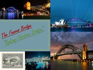
- 2. The Sydney Harbour Bridge is a steel through arch bridge across Sydney Harbour that carries rail, vehicular, bicycle, and pedestrian traffic between the Sydney central business district (CBD) and the North Shore. The dramatic view of the bridge, the Harbour, and the nearby Sydney Opera House is an iconic image of Sydney, and Australia. The bridge is nicknamed "The Coat hanger" because of its arch-based design. Furthermore, the bridge is ubiquitously known to Sydneysiders simply as "the Bridge". Carries 8 road lanes, 2 rail tracks, 1 pedestrian way and 1 cycleway Crosses Port Jackson (Sydney Harbour) Locale Sydney, Australia Official name Sydney Harbour Bridge Characteristics Design Through arch bridge Total length 1,149 m (3,770 ft) Width 49 m (161 ft) Height 134 m (440 ft) Longest span 503 m (1,650 ft) Clearance below 49 m (161 ft) at mid-span History Construction begin 28 July 1923 Construction end 19 January 1932 Opened 19 March 1932 Inaugurated 19 March 1932 Statistics Toll Time of day tolling (southbound only)
- 3. The southern (CBD) end of the bridge is located at Millers Point in The Rocks area, and the northern end at Milsons Point in the lower North Shore area. There are six original lanes of road traffic through the main roadway, plus an additional two lanes of road traffic on its eastern side, using lanes that were formerly tram tracks. Adjacent to the road traffic, a path for pedestrian use runs along the eastern side of the bridge, whilst a dedicated path for bicycle use only runs along the western side. Finally, between the main roadway and the western bicycle path are two lanes used for railway tracks, servicing the T1 North Shore Line for Sydney Trains.
- 4. The arch is composed of two 28-panel arch trusses; their heights vary from 18 m (59 ft.) at the Centre of the arch to 57 m (187 ft.) at the ends next to the pylons.( At the side the give n picture shows the nut or screw which tights Sydney Harbour Bridge)
- 5. At each end of the arch stands a pair of 89 m (292 ft.) high concrete pylons, faced with granite. (The south-eastern pylon containing the tourist lookout, made of granite quarried at Moruya, NSW.)
- 7. EARLY PROPSAL There had been plans to build a bridge as early as 1815, when convict and noted architect Francis Greenway reputedly proposed to Governor Lachlan Macquarie that a bridge be built from the northern to the southern shore of the harbour. In 1825, Greenway wrote a letter to the then "The Australian" newspaper stating that such a bridge would "give an idea of strength and magnificence that would reflect credit and glory on the colony and the Mother Country".
- 8. PLANNING In 1914 J.J.C. Bradfield was appointed "Chief Engineer of Sydney Harbour Bridge and Metropolitan Railway Construction", and his work on the project over many years earned him the legacy as the "father" of the bridge. Bradfield's preference at the time was for a cantilever bridge without piers, and in 1916 the NSW Legislative Assembly passed a bill for such a construction, however it did not proceed as the Legislative Council rejected the legislation on the basis that the money would be better spent on the war effort. Following World War I, plans to build the bridge again built momentum. Bradfield persevered with the project, fleshing out the details of the specifications and financing for his cantilever bridge proposal, and in 1921 he travelled overseas to investigate tenders. On return from his travels Bradfield decided that an arch design would also be suitable and he and officers of the NSW Department of Public Works prepared a general design for a single-arch bridge based upon New York City's Hell Gate Bridge. In 1922 the government passed the Sydney Harbour Bridge Act No. 28, specifying the construction of a high-level cantilever or arch bridge across the harbour between Dawes Point and Milsons Point, along with construction of necessary approaches and electric railway
- 9. CONSTRUCTION The building of the bridge was under the management of Bradfield. Three other people heavily involved in the bridge's design and construction were Lawrence Ennis, Edward Judge, and Sir Ralph Freeman. Ennis was the engineer-in-charge at Dorman Long and Co and the main on-site supervisor (Bradfield visited occasionally throughout the project and, in particular, at many key stages of the project, to inspect progress and make managerial decisions), Judge was chief technical engineer of Dorman Long, and Freeman was hired by the company to design the accepted model in further detail. Later a bitter disagreement broke out between Bradfield and Freeman as to who actually designed the bridge. Another name connected with the bridge's design is that of Arthur Plunkett.
- 10. OPENING The bridge was formally opened on Saturday, 19 March 1932. Amongst those who attended and gave speeches were the state Governor, Sir Philip Game, the Minister for Public Works, and Lawrence Ennis. The Labor Premier of New South Wales, Jack Lang, was to open the bridge by cutting a ribbon at its southern end.
- 12. ROADS From the Sydney CBD side, motor vehicle access to the bridge is normally via Grosvenor Street, Clarence Street, Kent Street, the Cahill Expressway, or the Western Distributor. Drivers on the northern side will find themselves on the Warringah Freeway, though it is easy to turn off the freeway to drive westwards into North Sydney or eastwards to Neutral Bay and beyond upon arrival on the northern side. The bridge originally only had four wider traffic lanes occupying the central space which now has six, as photos taken soon after the opening clearly show. In 1958 tram services across the bridge were withdrawn and the tracks replaced by two extra road lanes; these lanes are now the leftmost southbound lanes on the bridge and are still clearly distinguishable from the other six road lanes. Lanes 7 and 8 now connect the bridge to the elevated Cahill Expressway that carries traffic to the Eastern Distributor. In 1988, work began to build a tunnel to complement the bridge. It was determined that the bridge could no longer support the increased traffic flow of the 1980s. The Sydney Harbour Tunnel was completed in August 1992. It is intended for use only by motor vehicles.
- 13. TIDAL FLOW The bridge is equipped for tidal flow peration, permitting the direction of traffic flow on the bridge to be altered to better suit the morning and evening rush hours' traffic patterns.
- 14. TOLL The vehicular traffic lanes on the bridge are operated as a toll road. As of 27 January 2009 there is a variable tolling system for all vehicles headed into the CBD (southbound). The toll paid is dependent on the time of day in which the vehicle passes through the toll plaza. The toll varies from a minimum value of $2.50 to a maximum value of $4.There is no toll for northbound traffic (though taxis travelling north may charge passengers the toll in anticipation of the toll the taxi must pay on the return journey). There are toll plazas at the northern and southern ends. The two eastern lanes (which continue over the Cahill Expressway at the southern end of the bridge) have their tollbooths at the northern end, while the other southbound lanes (for CBD traffic) are serviced by tollbooths at the southern end of the bridge. There is a bridge-long median strip between lanes 6 and 7 to separate traffic which has already paid the toll (at the northern end) from other southbound traffic (which must pay the toll at the southern end).
- 15. PEDISTRIAN The pedestrian-only footway is located on the east side of the bridge. Access from the northern side involves climbing an easily spotted flight of stairs, located on the east side of the bridge at Broughton St, Kirribilli. Pedestrian access on the southern side is more complicated, but signposts in the Rocks area now direct pedestrians to the long and sheltered flight of stairs that leads to the bridge's southern end. These stairs are located near Gloucester Street and Cumberland Street
- 16. CYCLISTS The bike only cycle way is located on the west side of the bridge. Access from the northern side involves carrying or pushing a bicycle up a staircase, consisting of 55 steps, located on the west side of the bridge at Burton St, Milsons Point. A campaign to eliminate the steps on this popular cycling route to the CBD has been running since at least 2008.
- 17. RAIL The bridge lies between Milsons Point and Wynyard railway stations, located on the north and south shores respectively, with two tracks running along the western side of the bridge. These tracks are part of the North Shore railway line
- 19. 50th Anniversary Celebrations(1982) In 1982 the bridge celebrated the 50th anniversary of its opening. For the first time since its opening in 1932, the bridge was closed to vehicles, and pedestrians were allowed full access for the day. The celebrations were attended by Edward Judge, who represented Dorman Long.
- 20. Bicentennial Australia Day celebrations (1988) Australia's bicentennial celebrations on 26 January 1988 attracted large crowds in the bridge's vicinity as merrymakers flocked to the foreshores to view the events on the harbour. The highlight was the biggest parade of sail ever held in Sydney, square-riggers from all over the world, surrounded by hundreds of smaller craft of every description, passing majestically under the Sydney Harbour Bridge. The day's festivities culminated in a fireworks display in which the bridge was the focal point of the finale, with fireworks streaming from the arch and roadway. This was to become the pattern for later firework displays
- 21. Sydney New Year's Eve (1993–present) • The Harbour Bridge is an integral part of the Sydney New Year's Eve celebrations, generally being used in spectacular ways during the fireworks displays at 9:00 P.M. and midnight. In recent times, the bridge has included a rope light display on a framework in the centre of the eastern arch, which is used to complement the fireworks. As the scaffolding and framework are clearly visible for some weeks before the event, revealing the outline of the design, there is much speculation as to how the effect is to be realized.
- 22. Walk for Reconciliation (2000) In May 2000 the bridge was closed to vehicular access for a day to allow a special reconciliation march—the "Walk for Reconciliation"—to take place. This was part of a response to an Aboriginal Stolen Generations inquiry, which found widespread suffering had taken place amongst Australian Aboriginal children forcibly placed into the care of white parents in a little-published state government scheme. Between 200,000 and 300,000 people were estimated to have walked the bridge in a symbolic gesture of crossing a divide.
- 23. Sydney 2000 Olympics During the Sydney 2000 Olympics in September and October 2000, the bridge was adorned with the Olympic Rings. It was included in the Olympic torch's route to the Olympic stadium. The men's and women's Olympic marathon events likewise included the bridge as part of their route to the Olympic stadium. A fireworks display at the end of the closing ceremony ended at the bridge. The east-facing side of the bridge has been used several times since as a framework from which to hang static fireworks, especially during the elaborate New Year's Eve displays.
- 24. 75th anniversary (2007) In 2007, the 75th anniversary of its opening was commemorated with an exhibition at the Museum of Sydney, called "Bridging Sydney". An initiative of the Historic Houses Trust, the exhibition featured dramatic photographs and paintings with rare and previously unseen alternative bridge and tunnel proposals, plans and sketches.
- 25. Quotations
- 26. The "International Historic Civil Engineering Landmark" plaque presented to Sydney Harbour Bridge by the American Society of Civil Engineers in 1988.