Recomendados

Recomendados
Más contenido relacionado
La actualidad más candente
La actualidad más candente (20)
Similar a Oyster castle addition at bennett's point
Similar a Oyster castle addition at bennett's point (20)
Último
Último (20)
Oyster castle addition at bennett's point
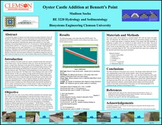
- 1. Oyster Castle Addition at Bennett’s Point Madison Socha BE 3220 Hydrology and Sedimentology Biosystems Engineering Clemson University Introduction There are multiple river banks in the low country of South Carolina that experience terrible bank erosion. The tip of Bennett’s Point, SC will be the focal point of this project. Located where Mosquito Creek splits off the Ashepoo River. This is a prime location for shrimping boats, fishing guides and recreational boaters because of the B&B Seafood boat landing and shrimp dock on Mosquito Creek 500 yards down from the waterway split. This brings a lot of boating activity to the small town. Many boat drivers do not respect the “No Wake Zone” buoys floating on the creek in front of B&B Seafood. So they are coming in at high speeds and throwing a large wake from their boats instead of lawfully idling to the docking area. Wakes being thrown from multiple boats slowly erodes the bank and the marsh grass on both sides of the creek. One side being an Army Corp of Engineer disposal site and the other being residential waterfront homes. Leaving neither party pleased with this destructive, careless act that is washing away their historical banks and beautiful marshland. As the low country continuously grows so will the amount of wakes being thrown into the river banks, thus increasing: danger in No Wake Zones, property damage and environmental harm. Objective We need to study how wake erosion effects different marshland soils and bank slopes. This will give us a better understanding of when the most harm is done to the river banks, and we can record height dimensions of wakes, tide water levels and soil loss amounts. This is extremely difficult to do due to the fact that this is marshland and not an agricultural site, therefore we will use two close representatives of marshland through two different agricultural soil loss strategies: 1. WEPP Model. 2. Soil Loss Equation. We also need to take into consideration the amount of rainwater runoff that is being dumped into the river, this could potentially raise the water level causing more or less harm to the river banks. We want to prove that man made erosion is the cause of the river bank erosion and completely eliminate it, and restore the environment. Materials and Methods The oyster castles will be placed in a pyramid shaped 100’ wall (see figure top right). This will determine the effectiveness of the erosion prevention strategy at a smaller scale. A small scale project is important because if the project fails then hundreds of thousands of dollars were not wasted on an entire stretch of river bank. The oyster castle wall will be 4 rows across on the bottom layer, 3 rows across on the second layer, 2 rows across on the third layer, and 1 row on the top layer. They will be placed by hand, in a pyramid shape for 100’. This will help block boat wakes from crashing into the shoreline and destroying wanted marshland. Materials Needed: 1. Oyster Castles (800) 2. Workers (3) 3. 18 Wheeler (1) 4. Lowtide 5. 5’x 5’x 1” board (20) 6. Obstruction Sign (2) Results Conclusions The final conclusion of the project was a success. The design worked effectively in not only stopping bank erosion from careless boaters’ wakes, but also regenerating marshland and marsh grass environment. After 1 year, the bank behind the oyster castle began to build sediment at least 6 inches higher. After 2 years grass began to grow with sediment still building. In the 3rd year the sediment was almost fully replaced and grass has began growing all the way to the edge of the wall. Thus proving the oyster castle design experiment a effective, and prevented careless boaters from destroying this section of river bank. (At the bottom of the poster you will find photographs of my completed design method in chronological order.) References 1. Kingsley-Smith, Peter. April 20, 2018. National Estuarine Research Reserve System. “A background to oyster reef habitat restoration: project techniques, criteria, and capabilities”. 2. November 25, 2014. Royal Oysters in South Carolina. 3. Owino, Dr. Tom. April 23, 2018. BE 3220 Unpublished Notes. . Acknowledgements I would like to thank Dr. Glen Haynes for allowing me to help him with this project on his shoreline at Bennett’s Point. I would also like to thank Mrs. Robin Socha for clarifying the oyster castle permit procedure. Abstract I examined the impact of natural river bank erosion occurring at Bennett’s Point, SC through two different strategies to prove that erosion was occurring through human causes. In my first strategy, I selected the WEPP Model (mainly used for other purposes like agriculture), and picked the options most similarly to a river bank. Resulting in an average annual soil loss of 2.135 tons/acre-yr with the addition of an average annual yield of 2.135 tons/acre-yr. In my second strategy I hand calculated the average annual soil loss, and I found that T=1.4112 tons/acre-yr. The 0.7238 tons/acre-yr difference is due to parameter restrictions in the WEPP Model. Even though there should be zero soil loss to equal amounts of yield, local land owners at Bennett’s Point have observed massive amounts of marshland eroding from the river bank, further proving the soil loss is due to human related activity at Bennett’s Point. The following image is the output data from WEPP model. The calculations in the below portray events without boat wake erosion, strictly natural erosion. 1. 2/10/13 8/20/14 3/18/15 6/20/16 6/18/17 3/31/1811/31/17 Soil Type: Blount (“near shore soils”, closest soil to marshland found) Soil Slope: 5% (Blount soil found in 1-6% slope, also most realistic to Bennett’s Point river bank slope) Cover Type: Wheat (closest cover to Spartina alterniflora1 found in marshland) Length: 40’ (length of marshland with respect to slope direction) Width: 100’ (distance used for oyster castle on riverbank) Calculation Area of Interest: 40’ x 100’ = 4,000ft2 Avg Annual Soil Loss: 2.135 tons/acre-yr Avg Annual Soil Loss in 4,000ft2: 0.196 tons/yr 2. Soil Loss Equation T=RKLSCP (Equation 1) R=400 (Beaufort County, closest to Bennett’s Point) K=0.24 (sandy loam soil) LS factor=0.49 (40’ Length, 5% slope) C=.03 (CCCCC, no till, RL, closest cropping strategy to untouched Spartina grass) P=1 T=1.4112 tons/acre-yr Avg Annual Soil Loss in 4,000ft2: 0.130 tons/yr Figure 1: WEPP model