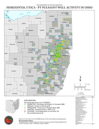
ODNR Map Showing Utica Shale Wells Permitted & Drilled in Ohio, as of 12/6/13
•
1 recomendación•2,047 vistas

A handy map from the Ohio Department of Natural Resources that shows where Utica Shale drilling is happening in the state. It has different colored dots to denote where permits have been issued, where wells have been drilled, and where wells have been drilled and are now producing. Running along the right bottom corner is a tally (as of 12/6/13) for how many permits have been issued by driller, which now totals over 1,000 permits.
Recomendados

Recomendados
Más contenido relacionado
Más de Marcellus Drilling News
Más de Marcellus Drilling News (20)
Último
Último (17)
ODNR Map Showing Utica Shale Wells Permitted & Drilled in Ohio, as of 12/6/13
- 1. OHIO DEPARTMENT OF NATURAL RESOURCES HORIZONTAL UTICA - PT PLEASANT WELL ACTIVITY IN OHIO LAKE ERI E LA KE ASHTABULA GEAUGA CUYAHOGA ERIE TRUMBULL LORAIN PORTAGE HURON MEDINA SUMMIT MAHONING ASHLAND WAYNE STARK RICHLAND COLUMBIANA HOLMES RROW TUSCARAWAS CARROLL JEFFERSON KNOX COSHOCTON HARRISON LICKING GUERNSEY BELMONT MUSKINGUM NOBLE FAIRFIELD PERRY 0 10 20 miles MONROE MORGAN 0 WASHINGTON HOCKING EXPLANATION Horizontal well status as of 11/30/2013 PERMITTED - Permitted, Not Drilled, or Canceled (389) DRILLED - Drilled or Drilling (318) PRODUCING - Producing or Plugged Back (284) INACTIVE - Drilled Inactive or Shut in (2) PLUGGED - Final Restoration or Lost Hole (10) Dry and Abandoned (3) Well permit information from the ODNR Division of Oil and Gas Resources Management Recommended citation: Ohio Department of Natural Resources, 2013, Horizontal Utica-Point Pleasant Well Activity in Ohio: Columbus, scale 1:1,300,000, revised 12/6/2013. 10 20 30 kilometers 1:1,300,000 1 inch = 21 miles OPERATOR AMERICAN ENERGY UTICA LLC ANADARKO E & P ONSHORE LLC ANTERO RESOURCES CORPORATION ATLAS NOBLE LLC BEUSA ENERGY LLC BP AMERICA PRODUCTION COMPANY BRAMMER ENGINEERING INC CARRIZO (UTICA) LLC CHESAPEAKE EXPLORATION LLC CHEVRON APPALACHIA LLC CNX GAS COMPANY LLC DEVON ENERGY PRODUCTION CO ECLIPSE RESOURCES I LP EM ENERGY OHIO LLC ENERVEST OPERATING L EQT PRODUCTION COMPANY GULFPORT ENERGY CORPORATION HALCON OPERATING COMPANY INC HALL DRILLING LLC (OIL & GAS) HESS OHIO DEVELOPMENTS LLC HG ENERGY LLC HILCORP ENERGY COMPANY MOUNTAINEER KEYSTONE LLC PDC ENERGY INC R E GAS DEVELOPMENT LLC RICE DRILLING D LLC SIERRA RESOURCES LLC SWEPI LP TRIAD HUNTER LLC XTO ENERGY INC. TOTAL COUNT 5 12 54 8 1 4 2 5 553 7 37 13 19 1 17 8 91 11 5 43 23 15 8 17 26 5 3 1 7 5 1006