SlideShare una empresa de Scribd logo
1 de 8
Descargar para leer sin conexión
High resolution 3D UAV mappingHigh resolution 3D UAV mapping
of a quarryof a quarry
Hytola Engineering Oy matti.hytola@gmail.com
Suolahdentie 692 +358407776513
FIN-44330 HYTÖLÄ hytola.com
Hytola Engineering Oy did 3D UAV mapping of Nordkalk Lappeenranta, Finland quarry in November 2017. Task was to take images of
almost vertical walls with 1 cm GSD (Ground Sampling Distance → resolution). This means 10 000 pixels / m². A 3D meshes and point
clouds were processed from images with average point density of 1250 3D-points / m².
A multicopter type of a UAV (drone) was used for taking the images in four days. Short light time of a day and rainy weather were
limiting operation hours in a day. With optimal weather condititions imaging would have taken less than two days.
As area of the quarry was about 50 ha, 125 acres, it was clear that amount of data would be huge. Over 10000 20 Mpix pictures were
taken and 3D point cloud had over 1 000 000 000 points!
This report will descripe used method and results achieved.
Kuvaspisteiden sijainnit
Hytola Engineering Oy matti.hytola@gmail.com
Suolahdentie 692 +358407776513
FIN-44330 HYTÖLÄ hytola.com
Image capture
positions
The greatest challenge was to plan flight route so that distance from UAV to pit wall
would stay optimal for desired resolution with minimized risk of collision.
A 3D flight planning software by Hytola Engineering Oy was used to plan optimal
flight route for UAV. With this software it was possible to optimize UAV's camera
angle and tilt to match the slope to be mapped.
Whole quarry was divided to sectors. Size of each sector was defined by operation
time and and range of UAV with capacity of one battery. With speed of 5 m/s and GSD
of 1 cm UAV will fly a 6 km long route which converts to 12 ha area and 600 images.
High resolution 3D UAV mappingHigh resolution 3D UAV mapping
of a quarryof a quarry
Hytola Engineering Oy matti.hytola@gmail.com
Suolahdentie 692 +358407776513
FIN-44330 HYTÖLÄ hytola.com
3D model of the quarry was wanted to be in ETRS GK28 coordinate
system. Because of this and to match images taken in different time of
day, 11 signal plates, used as 3D ground control points, were placed
in quarry area. 4 plates were placed at top, 4 at medium height and 3
at bottom.
Quarry measurement team did
measure coordinates of the center
point for each signal plate.
High resolution 3D UAV mappingHigh resolution 3D UAV mapping
of a quarryof a quarry
Hytola Engineering Oy matti.hytola@gmail.com
Suolahdentie 692 +358407776513
FIN-44330 HYTÖLÄ hytola.com
Image capture positions in 3D- ja 2D- pictures. UAV did fly
automatically all routes needing high accuracy. Over
10 000 images were taken.
High resolution 3D UAV mappingHigh resolution 3D UAV mapping
of a quarryof a quarry
Hytola Engineering Oy matti.hytola@gmail.com
Suolahdentie 692 +358407776513
FIN-44330 HYTÖLÄ hytola.com
A photogrammetry program
was used for processing
images. Dimensionally
accurate ortoimage and
ortomosaic were generated.
And high resolution 3D
models and 3D point
clouds for each sector.
High resolution 3D UAV mappingHigh resolution 3D UAV mapping
of a quarryof a quarry
Hytola Engineering Oy matti.hytola@gmail.com
Suolahdentie 692 +358407776513
FIN-44330 HYTÖLÄ hytola.com
3D-model makes it possible to
do many kind of analysis to
target area. Here are three
different ways to display data.
Single color shaded
Color gradient by
altitude
Realistic surface
texture
High resolution 3D UAV mappingHigh resolution 3D UAV mapping
of a quarryof a quarry
Hytola Engineering Oy matti.hytola@gmail.com
Suolahdentie 692 +358407776513
FIN-44330 HYTÖLÄ hytola.com
A screen shot from
3D model
Part of image
zoomed
3D point cloud.
High density of
point cloud visible
in here.
High resolution 3D UAV mappingHigh resolution 3D UAV mapping
of a quarryof a quarry
Hytola Engineering Oy matti.hytola@gmail.com
Suolahdentie 692 +358407776513
FIN-44330 HYTÖLÄ hytola.com
Our company is specialised in UAV-
mapping and will produce material for
your needs: Area and volume
measurements, ortophotos,
ortomosaics, surface models,
elevation models, 3D point clouds an
3D models.
Cost effective and with quality
quarantee!
High resolution 3D UAV mappingHigh resolution 3D UAV mapping
of a quarryof a quarry

Más contenido relacionado

La actualidad más candente

Photogrametry_3D_Modelling[1]
Photogrametry_3D_Modelling[1]Photogrametry_3D_Modelling[1]
Photogrametry_3D_Modelling[1]
Joachim Nkendeys
 
On kps kilo pixel swath - asprs - armando guevara
On kps   kilo pixel swath - asprs - armando guevaraOn kps   kilo pixel swath - asprs - armando guevara
On kps kilo pixel swath - asprs - armando guevara
Armando Guevara
 
라이브드론맵 (Live Drone Map) - 실시간 드론 매핑 솔루션
라이브드론맵 (Live Drone Map) - 실시간 드론 매핑 솔루션라이브드론맵 (Live Drone Map) - 실시간 드론 매핑 솔루션
라이브드론맵 (Live Drone Map) - 실시간 드론 매핑 솔루션
Impyeong Lee
 
On kps kilo pixel swath - asprs - armando guevara
On kps   kilo pixel swath - asprs - armando guevaraOn kps   kilo pixel swath - asprs - armando guevara
On kps kilo pixel swath - asprs - armando guevara
Armando Guevara
 
Remotesensingandgisapplications
RemotesensingandgisapplicationsRemotesensingandgisapplications
Remotesensingandgisapplications
imaduddin91
 
OptimalViewsheds_FairfaxVA
OptimalViewsheds_FairfaxVAOptimalViewsheds_FairfaxVA
OptimalViewsheds_FairfaxVA
Hatteras Hoops
 
Sundt - Laser Scanning
Sundt - Laser ScanningSundt - Laser Scanning
Sundt - Laser Scanning
Alan Sanoja
 
Using Very High Resolution Satellite Images for Planning Activities in Mining
Using Very High Resolution Satellite Images for Planning Activities in MiningUsing Very High Resolution Satellite Images for Planning Activities in Mining
Using Very High Resolution Satellite Images for Planning Activities in Mining
Argongra Gis
 

La actualidad más candente (20)

OL3-Cesium: 3D for OpenLayers maps
OL3-Cesium: 3D for OpenLayers mapsOL3-Cesium: 3D for OpenLayers maps
OL3-Cesium: 3D for OpenLayers maps
 
LIDAR-derived DTM for archaeology and landscape history research some recent ...
LIDAR-derived DTM for archaeology and landscape history research some recent ...LIDAR-derived DTM for archaeology and landscape history research some recent ...
LIDAR-derived DTM for archaeology and landscape history research some recent ...
 
Photogrametry_3D_Modelling[1]
Photogrametry_3D_Modelling[1]Photogrametry_3D_Modelling[1]
Photogrametry_3D_Modelling[1]
 
On kps kilo pixel swath - asprs - armando guevara
On kps   kilo pixel swath - asprs - armando guevaraOn kps   kilo pixel swath - asprs - armando guevara
On kps kilo pixel swath - asprs - armando guevara
 
Svl underground utility photogrammetry survey
Svl underground utility photogrammetry surveySvl underground utility photogrammetry survey
Svl underground utility photogrammetry survey
 
Team SNUSAT ARLISS 2015
Team SNUSAT ARLISS 2015Team SNUSAT ARLISS 2015
Team SNUSAT ARLISS 2015
 
라이브드론맵 (Live Drone Map) - 실시간 드론 매핑 솔루션
라이브드론맵 (Live Drone Map) - 실시간 드론 매핑 솔루션라이브드론맵 (Live Drone Map) - 실시간 드론 매핑 솔루션
라이브드론맵 (Live Drone Map) - 실시간 드론 매핑 솔루션
 
On kps kilo pixel swath - asprs - armando guevara
On kps   kilo pixel swath - asprs - armando guevaraOn kps   kilo pixel swath - asprs - armando guevara
On kps kilo pixel swath - asprs - armando guevara
 
Remotesensingandgisapplications
RemotesensingandgisapplicationsRemotesensingandgisapplications
Remotesensingandgisapplications
 
Machine vision technique to avoid alignment failure in space launch vehicle
Machine vision technique to avoid alignment failure in space launch vehicleMachine vision technique to avoid alignment failure in space launch vehicle
Machine vision technique to avoid alignment failure in space launch vehicle
 
OptimalViewsheds_FairfaxVA
OptimalViewsheds_FairfaxVAOptimalViewsheds_FairfaxVA
OptimalViewsheds_FairfaxVA
 
Google Earth
Google EarthGoogle Earth
Google Earth
 
Web Map Service Client - EnviroInsite
Web Map Service Client - EnviroInsiteWeb Map Service Client - EnviroInsite
Web Map Service Client - EnviroInsite
 
Land surveying software and design solution
Land surveying software and design solutionLand surveying software and design solution
Land surveying software and design solution
 
Icaros Photogrammetric Suite (IPS) Workflow
Icaros Photogrammetric Suite (IPS) WorkflowIcaros Photogrammetric Suite (IPS) Workflow
Icaros Photogrammetric Suite (IPS) Workflow
 
#29 SUSB Expo 2014 PIX4D
#29 SUSB Expo 2014 PIX4D#29 SUSB Expo 2014 PIX4D
#29 SUSB Expo 2014 PIX4D
 
Sundt - Laser Scanning
Sundt - Laser ScanningSundt - Laser Scanning
Sundt - Laser Scanning
 
Lorenzo Martelletti Pix4D
Lorenzo Martelletti   Pix4DLorenzo Martelletti   Pix4D
Lorenzo Martelletti Pix4D
 
Using Very High Resolution Satellite Images for Planning Activities in Mining
Using Very High Resolution Satellite Images for Planning Activities in MiningUsing Very High Resolution Satellite Images for Planning Activities in Mining
Using Very High Resolution Satellite Images for Planning Activities in Mining
 
2018 GIS in the Rockies Vendor Showcase (Th): ERDAS Imagine What's New and Ti...
2018 GIS in the Rockies Vendor Showcase (Th): ERDAS Imagine What's New and Ti...2018 GIS in the Rockies Vendor Showcase (Th): ERDAS Imagine What's New and Ti...
2018 GIS in the Rockies Vendor Showcase (Th): ERDAS Imagine What's New and Ti...
 

Similar a 3D mapping of a quarry

Civilex Presentation Laser Scanning And Gpr March 2009 Ices
Civilex Presentation Laser Scanning And Gpr  March 2009  IcesCivilex Presentation Laser Scanning And Gpr  March 2009  Ices
Civilex Presentation Laser Scanning And Gpr March 2009 Ices
guesta50845
 
ScanMapBrochure2016_loRES
ScanMapBrochure2016_loRESScanMapBrochure2016_loRES
ScanMapBrochure2016_loRES
John Taylor
 

Similar a 3D mapping of a quarry (20)

EN_3DLS_Oil_Gas_Offshore
EN_3DLS_Oil_Gas_OffshoreEN_3DLS_Oil_Gas_Offshore
EN_3DLS_Oil_Gas_Offshore
 
3 d video streaming for virtual exploration of planet surface
3 d video streaming for virtual exploration of planet surface3 d video streaming for virtual exploration of planet surface
3 d video streaming for virtual exploration of planet surface
 
Revolutionize Land Surveying with Cutting-Edge Mapping Drones.pptx
Revolutionize Land Surveying with Cutting-Edge Mapping Drones.pptxRevolutionize Land Surveying with Cutting-Edge Mapping Drones.pptx
Revolutionize Land Surveying with Cutting-Edge Mapping Drones.pptx
 
3D Laser Scaning FPSO Mystras
3D Laser Scaning FPSO Mystras3D Laser Scaning FPSO Mystras
3D Laser Scaning FPSO Mystras
 
3D Laser Scaning FPSO Mystras
3D Laser Scaning FPSO Mystras3D Laser Scaning FPSO Mystras
3D Laser Scaning FPSO Mystras
 
Informe-fotogrametría.pdf
Informe-fotogrametría.pdfInforme-fotogrametría.pdf
Informe-fotogrametría.pdf
 
Informe-fotogrametría_Ruben_VAH.pdf
Informe-fotogrametría_Ruben_VAH.pdfInforme-fotogrametría_Ruben_VAH.pdf
Informe-fotogrametría_Ruben_VAH.pdf
 
DroneSurvey.pdf
DroneSurvey.pdfDroneSurvey.pdf
DroneSurvey.pdf
 
Civilex Presentation Laser Scanning And Gpr March 2009 Ices
Civilex Presentation Laser Scanning And Gpr  March 2009  IcesCivilex Presentation Laser Scanning And Gpr  March 2009  Ices
Civilex Presentation Laser Scanning And Gpr March 2009 Ices
 
Using senseFly Mapping Drones to Map Geomorphological Features in the Subanta...
Using senseFly Mapping Drones to Map Geomorphological Features in the Subanta...Using senseFly Mapping Drones to Map Geomorphological Features in the Subanta...
Using senseFly Mapping Drones to Map Geomorphological Features in the Subanta...
 
Critical Infrastructure Monitoring Using UAV Imagery
Critical Infrastructure Monitoring Using UAV ImageryCritical Infrastructure Monitoring Using UAV Imagery
Critical Infrastructure Monitoring Using UAV Imagery
 
5 Remarkable Benefits of Using Drone Surveying and Mapping
5 Remarkable Benefits of Using Drone Surveying and Mapping5 Remarkable Benefits of Using Drone Surveying and Mapping
5 Remarkable Benefits of Using Drone Surveying and Mapping
 
3D Laser Scanning FPSO Mystras
3D Laser Scanning FPSO Mystras3D Laser Scanning FPSO Mystras
3D Laser Scanning FPSO Mystras
 
HIPARC Sistemas e Aerolevantamentos
HIPARC Sistemas e AerolevantamentosHIPARC Sistemas e Aerolevantamentos
HIPARC Sistemas e Aerolevantamentos
 
Holographic
HolographicHolographic
Holographic
 
Rapid Laser Scanning the process
Rapid Laser Scanning the processRapid Laser Scanning the process
Rapid Laser Scanning the process
 
Remote Sensing Field Camp 2016
Remote Sensing Field Camp 2016 Remote Sensing Field Camp 2016
Remote Sensing Field Camp 2016
 
Study of Geo-Spatial Data Quality
Study of Geo-Spatial Data QualityStudy of Geo-Spatial Data Quality
Study of Geo-Spatial Data Quality
 
Scanning with drones
Scanning with dronesScanning with drones
Scanning with drones
 
ScanMapBrochure2016_loRES
ScanMapBrochure2016_loRESScanMapBrochure2016_loRES
ScanMapBrochure2016_loRES
 

Último

Call Girls in Ramesh Nagar Delhi 💯 Call Us 🔝9953056974 🔝 Escort Service
Call Girls in Ramesh Nagar Delhi 💯 Call Us 🔝9953056974 🔝 Escort ServiceCall Girls in Ramesh Nagar Delhi 💯 Call Us 🔝9953056974 🔝 Escort Service
Call Girls in Ramesh Nagar Delhi 💯 Call Us 🔝9953056974 🔝 Escort Service
9953056974 Low Rate Call Girls In Saket, Delhi NCR
 
result management system report for college project
result management system report for college projectresult management system report for college project
result management system report for college project
Tonystark477637
 
VIP Call Girls Ankleshwar 7001035870 Whatsapp Number, 24/07 Booking
VIP Call Girls Ankleshwar 7001035870 Whatsapp Number, 24/07 BookingVIP Call Girls Ankleshwar 7001035870 Whatsapp Number, 24/07 Booking
VIP Call Girls Ankleshwar 7001035870 Whatsapp Number, 24/07 Booking
dharasingh5698
 

Último (20)

Call Girls in Ramesh Nagar Delhi 💯 Call Us 🔝9953056974 🔝 Escort Service
Call Girls in Ramesh Nagar Delhi 💯 Call Us 🔝9953056974 🔝 Escort ServiceCall Girls in Ramesh Nagar Delhi 💯 Call Us 🔝9953056974 🔝 Escort Service
Call Girls in Ramesh Nagar Delhi 💯 Call Us 🔝9953056974 🔝 Escort Service
 
VIP Model Call Girls Kothrud ( Pune ) Call ON 8005736733 Starting From 5K to ...
VIP Model Call Girls Kothrud ( Pune ) Call ON 8005736733 Starting From 5K to ...VIP Model Call Girls Kothrud ( Pune ) Call ON 8005736733 Starting From 5K to ...
VIP Model Call Girls Kothrud ( Pune ) Call ON 8005736733 Starting From 5K to ...
 
Vivazz, Mieres Social Housing Design Spain
Vivazz, Mieres Social Housing Design SpainVivazz, Mieres Social Housing Design Spain
Vivazz, Mieres Social Housing Design Spain
 
UNIT-IFLUID PROPERTIES & FLOW CHARACTERISTICS
UNIT-IFLUID PROPERTIES & FLOW CHARACTERISTICSUNIT-IFLUID PROPERTIES & FLOW CHARACTERISTICS
UNIT-IFLUID PROPERTIES & FLOW CHARACTERISTICS
 
Unit 1 - Soil Classification and Compaction.pdf
Unit 1 - Soil Classification and Compaction.pdfUnit 1 - Soil Classification and Compaction.pdf
Unit 1 - Soil Classification and Compaction.pdf
 
The Most Attractive Pune Call Girls Budhwar Peth 8250192130 Will You Miss Thi...
The Most Attractive Pune Call Girls Budhwar Peth 8250192130 Will You Miss Thi...The Most Attractive Pune Call Girls Budhwar Peth 8250192130 Will You Miss Thi...
The Most Attractive Pune Call Girls Budhwar Peth 8250192130 Will You Miss Thi...
 
Thermal Engineering Unit - I & II . ppt
Thermal Engineering  Unit - I & II . pptThermal Engineering  Unit - I & II . ppt
Thermal Engineering Unit - I & II . ppt
 
University management System project report..pdf
University management System project report..pdfUniversity management System project report..pdf
University management System project report..pdf
 
result management system report for college project
result management system report for college projectresult management system report for college project
result management system report for college project
 
Intze Overhead Water Tank Design by Working Stress - IS Method.pdf
Intze Overhead Water Tank  Design by Working Stress - IS Method.pdfIntze Overhead Water Tank  Design by Working Stress - IS Method.pdf
Intze Overhead Water Tank Design by Working Stress - IS Method.pdf
 
Booking open Available Pune Call Girls Koregaon Park 6297143586 Call Hot Ind...
Booking open Available Pune Call Girls Koregaon Park  6297143586 Call Hot Ind...Booking open Available Pune Call Girls Koregaon Park  6297143586 Call Hot Ind...
Booking open Available Pune Call Girls Koregaon Park 6297143586 Call Hot Ind...
 
chapter 5.pptx: drainage and irrigation engineering
chapter 5.pptx: drainage and irrigation engineeringchapter 5.pptx: drainage and irrigation engineering
chapter 5.pptx: drainage and irrigation engineering
 
(INDIRA) Call Girl Meerut Call Now 8617697112 Meerut Escorts 24x7
(INDIRA) Call Girl Meerut Call Now 8617697112 Meerut Escorts 24x7(INDIRA) Call Girl Meerut Call Now 8617697112 Meerut Escorts 24x7
(INDIRA) Call Girl Meerut Call Now 8617697112 Meerut Escorts 24x7
 
VIP Call Girls Ankleshwar 7001035870 Whatsapp Number, 24/07 Booking
VIP Call Girls Ankleshwar 7001035870 Whatsapp Number, 24/07 BookingVIP Call Girls Ankleshwar 7001035870 Whatsapp Number, 24/07 Booking
VIP Call Girls Ankleshwar 7001035870 Whatsapp Number, 24/07 Booking
 
data_management_and _data_science_cheat_sheet.pdf
data_management_and _data_science_cheat_sheet.pdfdata_management_and _data_science_cheat_sheet.pdf
data_management_and _data_science_cheat_sheet.pdf
 
(INDIRA) Call Girl Bhosari Call Now 8617697112 Bhosari Escorts 24x7
(INDIRA) Call Girl Bhosari Call Now 8617697112 Bhosari Escorts 24x7(INDIRA) Call Girl Bhosari Call Now 8617697112 Bhosari Escorts 24x7
(INDIRA) Call Girl Bhosari Call Now 8617697112 Bhosari Escorts 24x7
 
Thermal Engineering -unit - III & IV.ppt
Thermal Engineering -unit - III & IV.pptThermal Engineering -unit - III & IV.ppt
Thermal Engineering -unit - III & IV.ppt
 
ONLINE FOOD ORDER SYSTEM PROJECT REPORT.pdf
ONLINE FOOD ORDER SYSTEM PROJECT REPORT.pdfONLINE FOOD ORDER SYSTEM PROJECT REPORT.pdf
ONLINE FOOD ORDER SYSTEM PROJECT REPORT.pdf
 
UNIT-II FMM-Flow Through Circular Conduits
UNIT-II FMM-Flow Through Circular ConduitsUNIT-II FMM-Flow Through Circular Conduits
UNIT-II FMM-Flow Through Circular Conduits
 
BSides Seattle 2024 - Stopping Ethan Hunt From Taking Your Data.pptx
BSides Seattle 2024 - Stopping Ethan Hunt From Taking Your Data.pptxBSides Seattle 2024 - Stopping Ethan Hunt From Taking Your Data.pptx
BSides Seattle 2024 - Stopping Ethan Hunt From Taking Your Data.pptx
 

3D mapping of a quarry

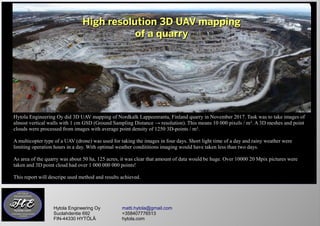
  • 1. High resolution 3D UAV mappingHigh resolution 3D UAV mapping of a quarryof a quarry Hytola Engineering Oy matti.hytola@gmail.com Suolahdentie 692 +358407776513 FIN-44330 HYTÖLÄ hytola.com Hytola Engineering Oy did 3D UAV mapping of Nordkalk Lappeenranta, Finland quarry in November 2017. Task was to take images of almost vertical walls with 1 cm GSD (Ground Sampling Distance → resolution). This means 10 000 pixels / m². A 3D meshes and point clouds were processed from images with average point density of 1250 3D-points / m². A multicopter type of a UAV (drone) was used for taking the images in four days. Short light time of a day and rainy weather were limiting operation hours in a day. With optimal weather condititions imaging would have taken less than two days. As area of the quarry was about 50 ha, 125 acres, it was clear that amount of data would be huge. Over 10000 20 Mpix pictures were taken and 3D point cloud had over 1 000 000 000 points! This report will descripe used method and results achieved.
  • 2. Kuvaspisteiden sijainnit Hytola Engineering Oy matti.hytola@gmail.com Suolahdentie 692 +358407776513 FIN-44330 HYTÖLÄ hytola.com Image capture positions The greatest challenge was to plan flight route so that distance from UAV to pit wall would stay optimal for desired resolution with minimized risk of collision. A 3D flight planning software by Hytola Engineering Oy was used to plan optimal flight route for UAV. With this software it was possible to optimize UAV's camera angle and tilt to match the slope to be mapped. Whole quarry was divided to sectors. Size of each sector was defined by operation time and and range of UAV with capacity of one battery. With speed of 5 m/s and GSD of 1 cm UAV will fly a 6 km long route which converts to 12 ha area and 600 images. High resolution 3D UAV mappingHigh resolution 3D UAV mapping of a quarryof a quarry
  • 3. Hytola Engineering Oy matti.hytola@gmail.com Suolahdentie 692 +358407776513 FIN-44330 HYTÖLÄ hytola.com 3D model of the quarry was wanted to be in ETRS GK28 coordinate system. Because of this and to match images taken in different time of day, 11 signal plates, used as 3D ground control points, were placed in quarry area. 4 plates were placed at top, 4 at medium height and 3 at bottom. Quarry measurement team did measure coordinates of the center point for each signal plate. High resolution 3D UAV mappingHigh resolution 3D UAV mapping of a quarryof a quarry
  • 4. Hytola Engineering Oy matti.hytola@gmail.com Suolahdentie 692 +358407776513 FIN-44330 HYTÖLÄ hytola.com Image capture positions in 3D- ja 2D- pictures. UAV did fly automatically all routes needing high accuracy. Over 10 000 images were taken. High resolution 3D UAV mappingHigh resolution 3D UAV mapping of a quarryof a quarry
  • 5. Hytola Engineering Oy matti.hytola@gmail.com Suolahdentie 692 +358407776513 FIN-44330 HYTÖLÄ hytola.com A photogrammetry program was used for processing images. Dimensionally accurate ortoimage and ortomosaic were generated. And high resolution 3D models and 3D point clouds for each sector. High resolution 3D UAV mappingHigh resolution 3D UAV mapping of a quarryof a quarry
  • 6. Hytola Engineering Oy matti.hytola@gmail.com Suolahdentie 692 +358407776513 FIN-44330 HYTÖLÄ hytola.com 3D-model makes it possible to do many kind of analysis to target area. Here are three different ways to display data. Single color shaded Color gradient by altitude Realistic surface texture High resolution 3D UAV mappingHigh resolution 3D UAV mapping of a quarryof a quarry
  • 7. Hytola Engineering Oy matti.hytola@gmail.com Suolahdentie 692 +358407776513 FIN-44330 HYTÖLÄ hytola.com A screen shot from 3D model Part of image zoomed 3D point cloud. High density of point cloud visible in here. High resolution 3D UAV mappingHigh resolution 3D UAV mapping of a quarryof a quarry
  • 8. Hytola Engineering Oy matti.hytola@gmail.com Suolahdentie 692 +358407776513 FIN-44330 HYTÖLÄ hytola.com Our company is specialised in UAV- mapping and will produce material for your needs: Area and volume measurements, ortophotos, ortomosaics, surface models, elevation models, 3D point clouds an 3D models. Cost effective and with quality quarantee! High resolution 3D UAV mappingHigh resolution 3D UAV mapping of a quarryof a quarry