
Recomendados
Más contenido relacionado
La actualidad más candente
La actualidad más candente (19)
Destacado
Similar a NaturNet Plus Book (part 2)
Similar a NaturNet Plus Book (part 2) (20)
Más de NaturNetPlus
Más de NaturNetPlus (20)
NaturNet Plus Book (part 2)
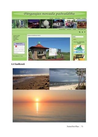
- 1. 4.4 Saulkrasti NaturNet Plus 71
- 2. 4.4.1 Saulkrasti municipality The Saulkrasti Municipality is located near the Baltic Sea in Vidzeme region of Latvia and encompasses a coastal forest area from the Lilaste River and a lake in the south to Zvejniekciems in the north spanning 17 kilometres along the shore of Gulf of Riga. The area of Saulkrasti municipality is 46.8 km2 Population: 6243 Distances from the centre of Saulkrasti to Riga – 37 km, Limbaži – 47 km, Sigulda – 40 km, Salacgrīva – 58 km Next to Inčupe on the coast of the sea lies one of the most beautiful natural sights – the White Dune, where the newlyweds go to exchange their rings. If you want to enjoy the picturesque landscape of Vidzeme coast and the Inčupe and Pēterupe estuaries, why not take the so-called Sunset Path winding from the White Dune to the centre of Saulkrasti. Saulkrasti houses a unique bicycle museum (http://www.velomuseum.tk/) holding the only collection of vintage bicycles in Latvia. The collection includes articles related to bicycles, competitive cycling, cycling societies and bicycle manufacturing. The exposition features the largest collection of bicycle manufacturers’ emblems in Eastern Europe. In the Saulkrasti city centre, there is a well-prepared beach, which obtained the National category bathing place quality certificate in summer of 2009 as a step towards obtaining the Blue Flag. Safety of families on the beach is ensured by Saulkrasti beach rescue service. Zvejniekciems with its stony beach is a favourite of painters and photographers. Next to it is the oldest port in Vidzeme – the Port of Skulte (http://www.skulteport.lv/), which is the largest of the small ports in Latvia and handles timber and renewable energy resources. It celebrated its 70th anniversary in 2009. Saulkrasti has cooperation partners in sister cities of Gnesta (Sweden), Odolanów (Poland) and Neringa (Lithuania). The municipality of Saulkrasti is a member of the Latvian Association of resort Towns and the Vidzeme Tourism Association, which marks the route for development of tourism and resort business in Saulkrasti. There are a total of 15 different hospitality facilities (http://www.saulkrasti.lv/en/ accommodation/50) in Saulkrasti: hotels, guest houses, camping sites, recreation bases and tent sites with the total capacity of 1032 persons. Those preferring active recreation will enjoy water sports, horse rides, paintball, skateboarding and saunas. You can also rent bicycles, quads and sports equipment. There are routes for cyclists and Nordic walking enthusiasts or cross-country skiers in winter, thus active recreation is possible all year round. 72 NaturNet Plus
- 3. The beauty salons of Saulkrasti will offer a plentiful choice of health and beauty procedures. Saulkrasti is well characterised by its coat of arms: four rivers – Inčupe, Pēterupe, Ķīšupe, Aģe, five villages – Bādciems, Katrīnbāde (Pabaži), Pēterupe, Neibāde, Zvejniekciems, blue skies and sea and bright golden sun above it all. 4.4.2 History The resort of Saulkrasti was established in the 19th century, when the fishermen of Katrīnbāde village began renting out their houses for the summer and themselves staying in barns in the meantime. Visitors came from as far as Moscow and Saint Petersburg. In 1909, the resort town had 150 residents. In the late 19th and early 20th century, summer cottages began sprouting up near the sea gulf. Only seldomly were construction rights given to Latvians. Over the years, the range of summer- dwellers expanded. Saulkrasti was a popular holiday resort with Latvian cultural society in the first third of the 20th century. The area of Saulkrasti was only mentioned for the first time in the Chronicle of Henry of Livonia in the late 12th and early 13th century. It refers to small Livonian villages near the sea inhabited by very rebellious Liv peoples. In the 13th century this area was a part of Kubesele province and it was during this time that the first sacral building, St. Peter’s Chapel, was built. It is possible that this chapel has lent its name to Pērļupīte – Pēterupe (Peter’s River) and to the Livonian village of Pēterupe. In the 14th-15th centuries, the areas surrounding the castle mounds and centres built by Germans belonged to manors. In mid-16th century, the area of Saulkrasti came under the rule of Bīriņi (Kolcene) manor. The life was very hard in those times, as Vidzeme was very much coveted by Poles and from a German province became a part of Poland. The political circumstances change over time, but the owners of the Saulkrasti area remain the same. The life of the area changed rapidly in 1823. The son-in-law of the Count of Bīriņi Manor Ludvig August Mellin (1754-1834), the Baron of Lēdurga Karl von Reutern built the first cottages north of Pēterupe and established a new place for swimming, which was named Neubad (Neibāde) – German for “new bathing place”. In 1835, Alexis I. Gehran Postolkohrs (1792-1870), the other son-in-law of the Count of Bīriņi Ludvig August Mellin, bought this Neibāde resort from his brother-in-law Karl von Reutern. Both were intelligent German nobles who wanted to expand the Bīriņi estate with a large and spacious place for recreation by the sea. The Neibāde resort started really flourishing in 1857. Following the wedding of August von Pistolkohrs and the adopted daughter of the Saint Petersburg millionaire Stiglitz Emily Harder NaturNet Plus 73
- 4. and the receipt of 8 million (supposedly, golden roubles) in dowry, the construction of Bīriņi manor with a park was completed in 1860 and the construction works at the Neibāde beach commenced. One of the first objects built was the Neibāde resort club – KUHRHAUS. It was surrounded by other buildings related to the resort life, for example, the HAUSEN hotel, KUMĪ restaurant-villa opposite it and another two buildings: one built as a bathing house (an early form of SPA) and a summer hostel for the service staff. A park was built next to the resort building square. Neibāde resort had become the recreation destination of choice for the nobility of Vidzeme. Nobles from Vidzeme, including Tartu, Viljandi and Pärnu, as well as from Moscow, Saint Petersburg and elsewhere in the Russian Empire came to spend their summers here. There was a very bad connection by road to Riga. Pärnu was more accessible. Thus, this became a somewhat isolated resort. The nobles came to the new bathing place with their whole families, taking their own cooks, maids and servants with them. Neibāde was popularly known as the summer cottage area of Pēterupe or the “lord’s end”. Until the mid-19th century, Neibāde was wholly owned by the Bīriņi manor. The manor offered cottages for rent, dinners at restaurants and interesting evening events in the resort house for the nobility. The nobles preferred an intelligent kind of relaxation, they spent their leisure time mainly listening to lectures about natural sciences, literature and arts. Recreation was all about mental relaxation, seaside walks and spending a lot of time in fresh air. The swimming in the sea was also very different from the beaches of Riga. There were certain hours when only ladies or only gentlemen were allowed on the beach: it was customary to bathe naked without swimming suits. Evening entertainment consisted of orchestra performances, dances held by a designated dance master who started the balls and announced which dance will be danced. However, the resort life was very expensive therefore, in 1875, the owner of Bīriņi manor started selling off land plots to other nobles who wanted to build their cottages. However, not everyone who had the money was entitled – the social status and the title were important, although not as strictly as before. In a short time, by the beginning of the 19th century, the area of Neibāde was covered with new, beautiful and luxurious cottages. Most of the well-known nobles of Vidzeme had a cottage there. Spectacular and magnificent manors were built by Count Kampenhausen, Prince Lieven, Barons Adas, Wolf, Klot, Ulrich and others. The Baron of Ērgļi Gustav Rudolf von Tranzej also visited the place with his suite of servants, including writer Rudolf Blaumanis’ father Matīss Blaumanis, who was a cook. The Barons Pistolkohrs improved the life around Neibāde by building a doctorate, a church and a pharmacy in Pēterupe, improving roads, opening the Kāpu Ķīši – Plade school for the children of peasants and fishermen. Neibāde suffered heavily in World War One. There was no heavy bombardment, but the trench life proved to be disastrous for Neibāde. Russian soldiers roamed around Saulkrasti and looted 74 NaturNet Plus
- 5. whatever was possible. The books in the barons’ libraries were used for rolling cigarettes and the furniture as firewood. Land reform commenced following the World War One. The cottages were taken away from the nobles and redistributed according to the reform rules: given to various officials, recipients of the Order of Lāčplēsis, heroes of World War One and others either for free or for a fee. The economic activity such as markets and different societies had mainly moved to Pēterupe following the war. Neibāde was a quiet area, which only saw some activity in the summer. In 1933, the villages of Pēterupe and Neibāde were joined together and renamed Saulkrasti. At this time, there were a number of societies actively functioning in both Neibāde and Pēterupe. Until World War Two, Saulkrasti was the site of the rest-house of Latvian textile workers and the summer camp of the Latvian children’s aid society in “Rūķīši”. With the inauguration of the Saulkrasti section of Riga-Rūjiena rail line in 1934, came an increasing number of intellectuals from Riga who wanted to relax in peace and quiet. Among them were Alfrēds Kalniņš, Tija Banga, Lilija Šmithene and others. World War Two brought great losses to Saulkrasti too. Although there was no actual fighting, almost every year there was the German front line with trenches and fortifications. After the war, the resort life recovered slowly. There was a boom of formation of gardening societies around Saulkrasti, which caused inconvenience to the locals. The infrastructure of the urban village was not ready to cope with the influx of people. In 1933, the villages of Pēterupe and Neibāde were joined together and renamed Saulkrasti. The name “Saulkraste” was chosen by the local writer Emīls Cīrulis based on the setting of his play “Blossom Time”. In 1950 Pabaži was annexed to Saulkrasti, in 1967 – Zvejniekciems and in 1991 Saulkrasti was granted a city status. 4.4.3 Website The website is accessible at: http://www.saulkrasti.lv/en NaturNet Plus 75
- 6. 4.5 Siauliai Šiauliai district municipality occupies the central part of Šiauliai county. It is situated at the crossing of three geographical regions – the borders of the slope of the Žemaičiai Upland of the Rytų (Eastern) Ž emaitija Plateau, the lowland of the middle reaches of the Venta and the lowland of Mūša-Nemunėlis. The area of the district covers part of the Kurtuvėnai Regional Park. The municipality is crossed by the Venta with tributaries the Ringuva, Žižma, the tributaries of the Mūša – the Einautas, Kulpė; there are the headwaters of the Švėtė and the Dubysa. There are 27 natural lakes, as well as artificial lakes (those of Talsa, Gelsva, Ginkūnai), artificial ponds. There are the large forests of Gruzdžiai, Gubernija, Gulbinai, Rėkyva. Important architectural monuments – the church of St Michael the Archangel and sepulchral chapel in Šakyna, windmills in Meškuičiai and Žaliūkės, castle mounds of Bubiai, Šilėnai. Twelve kilometres from Šiauliai, near the Šiauliai–Riga highway and railway, there is the Jurgaičiai (Domantai) castle mound (known as the Hill of Crosses), from times immemorial called by the locals the hill of prayer, the hill of a castle, the holy hill. Šiauliai is a town of Northern Lithuania, located on eastern slopes of Žemaičiai Upland, at the watershed of the basins of the Mūša, Dubysa, Venta and Nevėžis rivers. The urban scenery is enlivened by low hills, lakes, ponds and parks. In the southern part of Šiauliai, there is the tenth largest lake in Lithuania – Rėkyva Lake, surrounded by marshes and peat bogs. The hilliest, 76 NaturNet Plus
- 7. picturesque eastern part of Šiauliai is adorned with Salduvė pond. Talša Lake with its environs is a historically, culturally, economically and recreationally important location of Šiauliai. There are as many as 16 larger and smaller parks. Didždvaris, Gubernija and Rėkyva parks are included on the list of cultural values. There are about 40 cultural monuments – the church of Sts Peter and Paul, former palace of Ch. Frenkel (1908, today –Aušra museum), central building of a post office (1939) and others. The main celebration – the Day of the Battle of Saule and the data of birth of Šiauliai town, celebrated on the 22nd of September. 4.5.1 The area The 5 most visited destinations in Šiauliai. 1. Sts. Apostels Peter and Paul Cathedral Aušros Path 3, Šiauliai The building was erected in the Renaissance style with quite a few features typical of medieval architecture. In 1997 the church was granted a cathedral status. There is a great number of stories telling why the Cathedral was built at this place, and not somewhere else. One legend tells us that once upon a time a huge ox wandered to Šiauliai, lay down to rest, and passed away while sleeping. As time passed, a wind covered the dead ox with dust and sand, and thus a small hill appeared. It is the reason why Sts. Apostles Peter and Paul's Cathedral stands today on this hill. 2. Sundial Square Ežero St. - St. Šalkauskio St., Šiauliai The extraordinary 750th anniversary of the city's existence in 1986 motivated the proper acknowledgment of the significance of this date. The competition for the reconstruction of the square was announced in 1981, and it was won by a trio of architects from Šiauliai: A. Černiauskas, R. Jurėla and A. Vyšniūnas. The centrepiece of Sundial Square is the gilded and bronze-ornamented decorative sculpture Šaulys (Archer) by Stanislovas Kuzma. It is almost four metres high. The sculpture, often referred to as the Golden Boy, and the numbers 12, 3 and 6, indicating the hours and infused into the pavement of the square in a way unify the three symbols of Šiauliai: the sun, representing the Battle of the Sun that took place on the city grounds, the archer that the city's name derives from, and the time that has passed since the name of the city was mentioned for the first time (in 1236). It is the highest sundial in Lithuania. NaturNet Plus 77
- 8. 3. Chaimas Frenkelis Villa Vilniaus Street 74, Šiauliai The Šiauliai Aušros Museum's subdivision Chaimas Frenkelis Villa is the only architectural monument in Šiauliai and one of a few in Lithuania built in the Art Nouveau (Secession, Jugend) style. The interiors of the building distinguish themselves with ornate wooden decoration, stuccowork and imposing fragments of frescos. The first part of the Exposition "A Provincial Manor and a Town at the middle of the 19th - the middle of the 20th c." creates a stylized environment of an estate. There are 4 gallery (Eastern Art Gallery, the Kings' Gallery, the Landords portraits' Gallery and The Gallery) and 4 interior halls (The Library, The Yellow and The Green Salons, and The Dining Room). The second part of the hall - "The Provincial Town" - is equipped with retro cinema hall "Kapitol" , prewar streets and a reconstruction of a shop. The exposition "Jewish Heritage in Šiauliai: the Merchants Frenkelis" reflects a life of the prominent manufacturer, the owner of the Villa, Ch. Frenkelis. 78 NaturNet Plus
- 9. 4. Bicycle Museum Vilniaus g. 139, Šiauliai In1980, a public Bicycle Museum was established at Šiauliai Bicycle and Motor Factory "Vairas". In 1985, this museum was transferred to its present location and exposition was opened. In 1993, it became part of Šiauliai Aušros Museum. Bicycle Museum is the only such kind of museum in Lithuania. There is presented an exposition of bicycle history and evolution. It shows the first Lithuanian homework bikes made of wood and iron, Germany, England and other countries made bikes that were popular in Lithuania until the Second World War, as well as the modern bicycle, velomobileand their accessories. Temporary exhibitions and special video-shows are also arranged here. About 10,000 visitors per year get acquainted with this popular museum. 5. The Hill of Crosses The Hill of Crossesis situated sixteen kilometers to north from Šiauliai. It is seen from Šiauliai – Ryga highway. The hill is 60 meters long and 40-50 meters wide. The Hill of Crosses is a historical and architectural monument, a unique ensemble of folk art. Its peace, spirituality, authenticity, and sacred nature attract visitors. The hill itself sits on the Jurgaičiai-Domantai mound with a former ancient village dating back to the 13th-14th centuries. It became a sacred site in the 19th century. It is said that the first crosses were erected here by NaturNet Plus 79
- 10. the next-of-kin of the rebels that fell in the 1831 rebellion. The family members erected the crosses at this site because the Tsarist reign did not allow them to pay proper tribute to the graves of their relatives. Even more crosses were put up after the rebellion of 1863. At that time, the tradition of visiting and erecting crosses on the hill began to emerge. The Hill of Crosses became a place of vow making. According to another version, many crosses were put up after the Virgin Mary and baby Jesus appeared on the mound in the 7th decade of the 19th century; it was she who supposedly encouraged people to put crosses at this place. In 1850, there were 17 crosses on the hill, from 1895 to 1898 the number increased to 180, and in 1938 there were over 400 crosses. The number of crosses also grew during the period of Soviet occupation; in 1960, there were 2,500 large crosses alone. In 1994 during his visit to a Franciscan monastery of the mount of Verna (Italy), the Pope John Paul II encouraged the brothers to build a monastery by the Hill of Crosses. A hermit of the Franciscan Brothers was consecrated on July 7, 2000. It is built 300 meters away from the Hill and has sixteen cells. It serves as a novitiate of the Lithuanian Franciscan province of St. Casimir, but the monastery is also open to the pilgrims who look for silence and peace. 4.5.2 Information system Public institution Siauliai Tourism Information Centre (the Centre), the main purpose is to collect and organize various forms of information about tourist services, attractions and the city of Siauliai region locations and objects, publish and distribute information and publications, cataloguing, ordering customers accommodation, travel tickets , travel packages, tickets to theatres, concerts, sporting and other events to take care of tourism advertisement, organize events to promote tourism, sale of souvenirs and handicrafts products. Centre developing the tourism sector and make the city attractive to tourists and deliver Siauliai, as metropolitan centre in the country. Siauliai tourism information centre generate incoming tourism in the city of Siauliai and thus stimulate the economy, promote employment of people and private tourism service providers in revenue. On the Centre's services between economic effect impalpability, performance difficult to assess. Tourist Information Centre's activities are maintained outside the body, rather than inside it. In the website http://tic.siauliai.lt/ all information is now available in Lithuanian, Russian, English, German, French and Latvian languages, tourists and visitors can find a regularly updated relevant information about: • provide accommodation and food services • city bus ticket prices • intercity bus and train timetables • car rental service • tourist facilities in the city reach • description of the sights and history • museums • gallery 80 NaturNet Plus
- 11. • churches • cycling routes for travellers • organized tours, guide services across the Siauliai county • ecotourism • events • entertainment • services • maps • publications • links and contacts 4.5.3 Support for tourism In the Siauliai city 2007-2016 period Strategic Development Plan for the goal "To promote the tourism sectors in Siauliai city" to achieve the planned targets: • develop the infrastructure of public tourism; • promote tourism development; • increase awareness of the city for domestic and foreign tourism markets. Municipalities to meet the targets to comply with the various projects funded by EU funds. 4.5.4 Market strategy Mainly to tourist groups visiting Šiauliai, here it takes only one day; individual tourists often come to the Siauliai region of traveling all over Lithuania. Individuals who decide to stay a few days, mostly Šiauliai chosen as a stop for the night. The biggest tourist attraction in Šiauliai County – The Hill of Crosses. Tourism information, marketing activities in the field of development – the publications, participation in international exhibitions, working with the media. 2010 Siauliai Tourism Information Centre participated in international business and achievements show in Siauliai, which introduced the city and region services: travel, accommodation, meals, Transportation, entertainment and so on. Also in Siauliai city and district for students and families offered educational programs (puppet production, weaving, dismissal, culinary heritage, etc.), active entertainment and new attractions. The 2010 publish informative publications: • Brochure "Where to stay in Siauliai in Lithuanian and English languages, print run - 5,000 copies. • Brochure for international games Zalgiris Open 2010 "in English. NaturNet Plus 81
- 12. Šiauliai tourism information centre is actively exploiting online marketing tools, website www.siauliai.lt/tic hosted electronic tourist publications, maps, complete city photo gallery and video. In this way, a relatively small inputs, reached a wide audience interested in Šiauliai. Šiauliai tourism information centre in cooperation with the Lithuanian Tourism Information Centres abroad, and the State Department of Tourism, organized by the specialized media representatives visit to Šiauliai. 2010 Šiauliai was visited by: • French journalist, the only French tourist guide about Lithuania “Petit fute” author. • Catalan TV movie about photography in Lithuania. • Travel in the British TV 4th Lithuania was shot show Coatch trip. Siauliai University of folk music ensemble "The Sun" show will be demonstrated and taught with Lithuanian folk dances, visited the Hill of Crosses. • French national television France 5, show filmed Echappees Belles on the making of crosses and local cross producers. 4.5.5 Tourists Šiauliai tourism information centre is the only body-recording data on tourist arrivals to the city. Centre part of the National Tourism Information System (NTIRS) development. NTIRS – information about tourism resources and their use for tourism, as well as data on tourism services and the quality of the collection, handling, processing, storage, retrieval and presentation of a computerized information system for tourism information for public accessibility. 2010 the total number of visitors in the centre – 20 119, compared with 2009 statistics, the number of visitors increased by 25 percent. 2010 most visitors came from: • Latvia (1220) • German (673) • French (405) • Russia (324) • Poland (310) The city also enjoys visitors from Switzerland, the Netherlands, Belgium, Austria, Sweden, Finland, Norway, Great Britain, Italy, Portugal, Spain, Romania, Poland, Estonia, Czech Republic, Turkey, Japan, USA, China, Australia and Oceania. On the tourist's age, education or sex is not accrue any additional information. The most common tourist attractions: The Hill of Crosses, Šiauliai pedestrian boulevard, Sundial Square, St. Peter and Paul Cathedral. 82 NaturNet Plus
- 13. In 2011 August – September in Siauliai will be held Lithuania European Basketball Championships and it is expected tourists from Italy, Israel, France, Latvia, Germany and Serbia. In 2012 expected number of tourists arriving in 2012 organized TAFISA Sport Games “Siauliai 2012". 4.5.6 SWOT Analysis STRENGTHS • Ample recreation recourses (lakes, rivers, forests, the cost line). • Ample natural curative resources. • Rural landscape which is little urbanized. • Ample cultural and historic resources (ethic culture, architecture, museums, old towns). • Four tourism objects listed on the UNESC world heritage list. • Hospitable residents. • Relatively new tourism region. • Comparatively low (if compared to Western Europe) tourism service prices (food, public transport). • Quite dense road network. • Historic, cultural and ethnic relations between Lithuania and other countries (Poland, Latvia, Russia, Germany, Israel, USA). • Convenient geographic location – close to the huge tourism markets – Germany, Scandinavia, Finland, Russia, Poland. • Two main EU transport corridors (East – West, North – South) cross Lithuania. WEAKNESSES • Insufficient shaping of Lithuanian image as a state. • It is difficult for tourists from non-EU countries to enter the country because of the visa regime. • Passenger railway transport services are of not sufficient quality. • Undeveloped internal water transport as well as berth infrastructure. • Public institutions do not pay sufficient attention to tourism development. • Poor tourism information system (the lack of information on different languages, difficulty getting information on holidays, information is not relevant). • Insufficient choice in entertainment and leisure activities. • Insufficiently developed conference tourism infrastructure. • Insufficient focus on local tourism planning and marketing. • Undeveloped off-season tourism. • Difficulties to get into Lithuania by sea and land (insufficient quality of Polish roads). • No railway tracks in the South – North direction. NaturNet Plus 83
- 14. OPPORTUNITIES • Possibilities to use the EU structural funds in implementing different tourism service, infrastructure, marketing projects. • Development of resort tourism. • Development of wellness and recreation tourism. • Development of interregional importance tourism roads. • The need for tourism products expanding the business areas (conference, cruise, rural tourism, ecological tourism, active tourism, cultural cognitive tourism). • Improved investment climate, attractiveness. • Development of common international routes with the neighbouring countries. THREATS • Insufficient funding to promote tourism sector development opportunities. • Incapacity to establish the image of Lithuania as a sea state. • Irrational use of investment in tourism. • The competition of close tourism markets. • Incapacity to use EU structural funds and other foreign support. • Increasing migration of youth. 4.5.7 Website Šiauliai Tourism Information Center website is accessible at: www.siauliai.lt/tic 84 NaturNet Plus
- 15. 4.6 Šiauliai County Šiauliai County is situated in Northern Lithuania and includes Šiauliai city and municipalities of Akmenė, Joniškis, Kelmė, Pakruojis, Radviliškis and Šiauliai districts’. In Šiauliai County live circa 370 thousand inhabitants. General area of County is 8540 km. By the territory it is secondary county of Lithuania. Around the Šiauliai County is beautiful various nature: valleys of Dubysa, Mūša, Venta and other smaller rivers, clear lakes, scarce plants and animals in the forests, there is aplenty of important cultural memorials. 4.6.1 The area Places of interests in Šiauliai County 1. Kurtuvėnai Regional Park (Šiauliai District) Kurtuvenai Regional Park (KRP) was established in 1992, with the aim to protect hilly landscape of Kurtuvenai with forested and laky surroundings, its natural ecosystem and treasures of cultural heritage, create good recreation conditions, and encourage traditional lifestyle. Park area covers 17 252 ha, including 12 130 ha of forests. Whole parks territory is divided into several zone, where different limitations are applicable: conservation (nature NaturNet Plus 85
- 16. reserves), ecological priority (preservation), recreation, economic (forestry and agriculture) and living zones. Sparsely popu- lated, park territory has ~ 1200 local dwellers. KRP is situated on the edge of Samogitia hilly land, on the watershed of the Venta and Dubysa rivers. In North-Southern direction the park is crossed by three ridges separated by valleys and lake scoops. 30 small lakelets are swashing and 20 forest rivulets running in the shelter of forests. Kurtuvenai settlement is surrounded by nearly 100 fishery reservoirs. In the western part of the park there spurt well-known springs of Svile, which are considered to be the biggest in Lithuania. In scoops of former lakes there are many little swamps. Forests of KRP are highly appreciated by enthusiasts of orienteering, skiing, biking, riding horses and jogging sports. Guided tours are offered for those who wish to get closer to nature. 2. Kleboniškių Village (Radviliškis District) In the beautiful valley of the Daugyvenė river in an old rural area stretching for 18 ha, a village household museums establishing. Buildings of farmsteads typical to the beginning of the 19th century are brought here from neighbour environs, i.e. dwellings, outhouses such as granaries, bathhouses, haybarns, threshing-floors etc. Side by side with the standing farmsteads of the Kleboniškės village, sometime places are under restoration. In the intended exposition on 86 NaturNet Plus
- 17. household a great heed will be paid to fences, which bring out originality of farmsteads. Old trees of village and thatched roofs render some mystery to the Museum, while the settled farmsteads in the territory of exposition and everyday’s life of their inhabitants return visitors to reality. The expositions on rural household equipped in the farm buildings carry back to the end of the 19th century. A bathhouse is in operation. The expositions contain collections of jars, manual balances, butter-beaters, bread peels, flax combs, motors, a tractor made in 1926. The windmill built in 1884 is operating in the village. 3. Pakruojis Manor (Pakruojis District) This is the biggest extant manor ensemble, which consists of 34 buildings and a beautiful park. The founder of the ensemble was Teodor von Ropp, who built a classicist palace and subsidiary buildings in the first part of the XIX century, having classicist and romanticism elements. This ensemble extends along a curved compositional axis in the territory of 1 km, which borders with the road from Pakruojis to Linkuva and Kruoja stream. The building of the palace irradiates with grandeur, its architectural style belongs to the Late Classicism. It is said that the founder himself designed it with the help of the French language teacher Frederic Dubois de Montpereux. There is a spacious square dancing hall in it. In other buildings, beginning with the lodge of a gatekeeper, and ending with a water mill, contrastive decoration is used: the walls are made of stone and gravel, the rims of apertures and order elements are plastered and whitewashed. Now this building is restored. You can not only rest in this manor, but also get acquainted with remarkable architecture and remaining works of art. NaturNet Plus 87
- 18. 4. Botanical Garden (Akmenė District) Privat botanical garden was established by Antanas Čiapas 40 years ago. 358 various species of plants, compositions from stones, wood, metal and glass atracts many visitors to this place. This is an original island in a small town where growth of trees and bushes looks like fairy-tale world. This garden was included into the list of protected natural objects in 2000. 5. Žagarė (Joniškis District) Žagarė is a small town consisting of two historical parts: Old Zagare and New Zagare. It is located in the north of Lithuania, on the border with Latvia. The town is one of the most 88 NaturNet Plus
- 19. historical in the country, having first been mentioned in the history books in 1198, making it even older than Riga. An archeoligcal find in 1999, revealed evidence of a castle and settlement at Raktuve mound, inhabited by a Duke of Žiemgaliai [the ethnic region in which Zagare is located], dating back to the 9th Century. Žagare is rich in both cultural and natural heritage. The town centre is an urban monument, owing to the fact that its street network dates back to the 16th Century, and due to its 19th Century red brick buildings. In New Zagare, the Naryshkin Estate complex can be found. This is one of the largest manor house estates which belonged to the Naryshkin noble family. The central manor house was built in the classical style between 1836 – 1865 and is known for its grandeur and splendor. Other manor building still remaining are the icehouse, stables, three watch-houses, dairy, coach house, warehouse, riding hall, stableman‘s house, gardener’s house, brewers‘ house, and it is believed, the oldest remaining wind mill in Lithuania. Žagarė park is one of the most splendidly landscaped and architecturally impressive parks in Lithuania. Guests may wander around the park and view the exterior of the manor house and other buildings. The stables are still in use to this day – horses are bred and trained here, horse races are organized and horse-riding is available to the public. Zagare also boasts a Regional Park, which was established to preserve the landscape, the natural ecosystem of the Svete valley and Zagareforest. On the shores of Lake Zvelgaitis, visitors will find picnic shelters with log tables, and bird watching towers. 4.6.2 Akmenė Akmenė district municipality is located in the south-western part of Šiauliai County, at the border with Latvia. There is the eastern border of Žemaitija region; the region of Aukštaitija starts there. The district is situated in the lowland of the middle reaches of the largest river in the region – the Venta River. The territory is also crossed by its tributaries – the Virvytė, Vadakstis and Dabikinė. There is the Venta Regional Park, Kamanos, Purviai reserves, Papilė geological, Venta landscape reserves; there are hydrographical reserves extending along the Avižlys, Dabikinė and Virvytė rivers, the old parks of Dabikinė, Kruopiai, Papilė. There are 5 ponds, the largest whereof – Sablauskiai. To the north from Akmenė, there is one of the oldest oligotrophic bogs in Europe – Kamanos marshland. The largest forests – Pragalvojai, Kamanos, Latveliškiai, Girkančiai, Lydmiškis. There are two Papilė castle mounds, Luokava Hill, many tumuli and sacred places. NaturNet Plus 89
- 20. 4.6.3 Information system Information on tourism in region is limited. Tourism Centre is closed; maps and brochures are distributed irregular by tourism providers. The tourism information in website of municipality is not easy to find, because tourism information is created just in Lithuania language. In English language is published just general information about Akmene region. More information on website is available only in Lithuanian, so it is addressed only to Lithuanians. On website there are links to the place to visit in the region: regional parks, reservation, museums and other, but in most of them information is just in Lithuanian language. To increase their visibility need to create maps, routs in region, create all necessary information not just in Lithuanian but and in other languages. 4.6.4 Support for tourism One of the main problems impeding tourism is underdeveloped tourism infrastructure. Akmene district weeks are: lack of hotels, camping, resorts, bicycle paths, playground. In 2010-2015 year Strategic Development Plan of Akmenė district one of main objective is “Tourism and tourism infrastructure development”. For this objective implementing are sets sub objectives: • to promote inbound and local tourism, the recreation infrastructure; • information tools to promote tourism development scatter. Implementing targets municipality comply with the various projects funded by EU funds. E.g. "Paragiai manor management and its adaptation for tourism purposes“, the project value- 927 000 Lt, of which the municipality's contribution - 139 000 Lt, and the amount of support – 788 000 Lt, and other projects related to tourism promotion. One of the important project for tourist in Akmene district – “Tourism information system installation in Akmene district”. Project implementation allow to install the tourism information system (indicative signs, information boards at the popular sights, tourist information booths with individual district and city maps, sights, tourists and other relevant information), covering the entire Akmene district. 90 NaturNet Plus
- 21. 4.6.5 Website The website of Akmene District Municipality is accessible at: http://www.akmene.lt/?set_lang=en 4.7 Joniškis Joniškis district municipality is a situated in Northern Lithuania, at the border with Latvia. The largest part of the region is located on the Žiemgala Lowland. The territory is crossed by the rivers of Mūša, Platonis, Vilkija, Audruvis, Sidabra, Švėtė. Important objects of environmental protection – Pabaliai botanical, Vilkija hydrographical, Mūša tyrelis telmological reserves, Žagarė Regional and Skaistgirys parks. There are 28 ponds (the largest thereof – those of Žvelgaičiai, Ramoškiai, Beržėnai). The largest forests – those of Tyrelis, Žagarė, Reibiniai, Satkūnai, Didmiškis. The municipality is crossed by an important international highway Riga–Kryžkalnis– Kaliningrad, a railway line Tallinn–Warsaw. It is one of the most important agricultural regions of Lithuania. It also stands out among other regions with its peat bogs and resources of dolomites. It is an important centre of processing of agricultural products. There are castle mounds (those of Žvelgaitis, Raktuvė, Kalnelis), monuments to the memory of dead partisans (in the forests of Tyrelis, Montoriškiai and others), artistic monuments. Important architectural and cultural monuments of the 18th–19th centuries – the churches of St George in Skaistgirys, Sts Peter and Paul in Žagarė, St John the Baptist in Juodeikiai, a church of the Assumption in Joniškis; a mansion and a stud farm in Žagarė, Jakiškiai mansion. NaturNet Plus 91
- 22. 4.7.1 Information system Information about tourism in Joniškis district is publisched in Municipality of Joniskis district website www.joniskis.lt, in Joniskis Tourism and Business information center, and in Žiemgales tourism website www.ziemgaletourism.lv. In all this websites tourists can find: • actual information about Joniškis district; • events; • the place of interested; • active rest; • routes for tourist; • outgoing tourism; • staying overnight; • feeding; • places for events; • maps • other actual information Information is adressed not only for real, but and for potential region visitors. Informacion about district is presented in books and leaflets about Ž iemgala region. Nowadays are implementing projects which promote Ziamgala tradicions and Joniskis district are one part of Old Ziemgala region. 4.7.2 Support for tourism The most important factors in preventing the development of tourism in the Joniškis area - a small tourist supply (rural tourism services, tour services, excursions and services etc..) poor many of the cultural heritage objects in the physical condition. 4.7.3 Market strategy Aiming for more efficient development of tourism in the area, development and implementation of tourism projects increase the dissemination of information, works and services provided by Joniškis Tourism and Business Information canter, maps are allowed. Joniškis district is presented at international tourism exhibitions in Vilnius and Riga. In view of the visit sites, areas to tourism opportunities to promote crafts, educational and rural tourism in the area. 92 NaturNet Plus
- 23. 4.7.4 SWOT Analysis STRENGTHS • Region geographical position is convenient of passing traffic, tourism development; • Although there is no guarantee equal to or greater than the number of tourists increase, but the area is prone to guests spend more time in the area. This shows that the attractiveness of the future has the potential to grow. WEAKNESSES • Weakly-developed tourism sector – is not formed appropriate tourism infrastructure, tourists and district guests do not meet their needs provided by tourism-related service levels. OPPORTUNITIES • Region image and positioning in order to attract more tourists and potential residents. • Urban and regional infrastructure for tourism needs (passing tourists): car, bus, bicycle parking facilities, information signs, indications installation. • Active participation in taking full advantage of favourable opportunities for development of the region to attract and effectively assimilation of the 2007-2013 EU structural assistance. THREATS • Failure to properly use and targeted government and EU support. Too low public and private capital initiative to promote passive project implementation activities. 4.7.5 Website The website of Joniškis District Municipality is accessible at: http://www.joniskis.lt/Turizmas NaturNet Plus 93
- 24. 4.8 Kelmė Kelmė district municipality is located in the south-western part of Šiauliai County, on the Vidurio (Central) Žemaičiai Lowland and Rytų (Eastern) Žemaičiai Plateau. There are as many as 7 reserves (Šilkainiai geomorphologic, Šatrija landscape, etc.), part of the territory of Tytuvėnai, Kurtuvėnai, Dubysa, Varniai regional parks. The region is crossed by the Dubysa and the Venta rivers with tributaries. There are as many as 53 lakes (the largest whereof – Gauštvinis, Gludas, Bridvaišis, Karklėnai), 10 ponds (Aunuvėnai, Kentriai, Pašiaušė). The largest forests are Vainagiai, Patumšiai, Padubysis, and Tytuvėnai. There are about 10 parks, the better known whereof – that of Pagryžuvys. There are more than 70 folk artists in the district, who exhibit their works at various folk art exhibitions.Annual traditional events – folk art festival, Tytuvėnai summer festival, national festival Linas, a week of Gregorian chant and church tradition studies Ad Fontes, an international theatre festival , district choirs festival (biennial), a festival of country choirs and folklore groups ,art song festival and others. 4.8.1 Information system Information about tourism in Kelmė district all tourist can find in Minicipality of Kelmė district (www.kelme.lt), Kelmė Tourism and Business Information Centre (www.kelmevic.lt), Tytuvėnai Tourism Information Centre (www.tytuvenai.eu), Kražiai Tourism Information Centre (www.kraziai.lt). 94 NaturNet Plus
- 25. Information in foreign languages tourist could find just in Kelmė Municipality webpage. In other websites, which are informed about tourism in Kelmė district information is in Lithuanian. In Kelmė district are 4 regional parks, in which websites tourist can find information about them, maps, routes, and other necessary information. 4.8.2 Support for tourism Kelme district has a lot of intresting objects for tourists. There are good conditions to developed natural tourism in regional parks. One priority of Kelmė municipality is well developed tourism infrastructure. To implement this objective there are sets sub objectives till 2013: • to improve the tourism in Kelmes district; • preserve cultural heritage by adapting them for public purposes; • to spread information and create an attractive area image. 4.8.3 Website The website of Kelmė Tourism and Business Information Center is accessible at: http://www.kelmevic.lt/index.php?option=com_content&task=blogcategory&id=24&Itemid=36 NaturNet Plus 95
- 26. 4.9 Pakruojis Pakruojis district municipality is located in the north-eastern part of Šiauliai County, at the border with Latvia. The largest part of the area is covered by the lowlands of Žiemgala and Mūša-Nemunėlis. There are two state-protected parks. The municipality is crossed by the Mūša River with its tributaries the Kruoja, Daugyvenė, Šiladis. There are 9 ponds. There are a few forests, the largest whereof – Rozalimas, Gedžiūnai, Pakruojis, Klusiškiai. There is spruce, birch, aspen woods. Important cultural monuments are a church of Our Lady of the Rosary and an ensemble of buildings of a former monastery in Linkuva, Triškoniai chapel, a complex of two pubs in Žeimelis. There is the Pakruojis mansion, where a Frenchman Dubois de Montpereux, who was teaching there sometime, prepared and published the first geological map of Lithuania. Many spectators are annually attracted by motocross competitions in the Petrašiūnai motocross track and a bike show in Paežeriai. 4.9.1 Information system Information on tourism in region is limited. Pakruojis Recreation and Tourism Centre web site is available just from Municipality of Pakruojis district website and is established in Pakruojis Manor. Information on website is available only in Lithuanian, so it is addressed only to Lithuanians. Tourist can find all information about attraction in published links, but most of them are in Lithuanian too. In Pakruojis Recreation and Tourism Centre tourist can find: • tourist publications; • postcards; • T-shirts; • souvenirs of the city Pakruojis, Pakruojis Manor and Lithuania merchandise. Mostly in all objects you can find guide services, maps and routs, most relevant information. 4.9.2 Support for tourism The municipality plans to actively invest in tourism infrastructure development, allowing local entrepreneurs to make better working conditions and to attract to the area active flow of tourists. According to I priority in 2007-2013 year Strategic Development Plan of Pakruojis district one of main investments are planned for Tourism infrastructure (programs, strategies, marketing tools preparation, restoration of cultural heritage sites, recreational areas development of the cultural, educational tourism facilities modernization and development, sports facilities to tourism, water tourism development and customization tourism's tourist attractions Information System Development). 96 NaturNet Plus
- 27. To implement Strategic Development Plan objectives and sub objectives Pakruojis Municipality has recently implemented project “Part of Pakruojis Manor building reconstruction for cultural adaptation and public purposes”. 4.9.3 SWOT Analysis STRENGTHS • Large attractive cultural heritage items and 6 state reserves • High recreational and natural resource potential • Strong tourist image - Pakruojis - humour, beer, and crow's Capital WEAKNESSES • Cultural and natural tourism potential is not fully exploited • Undeveloped tourist infrastructure OPPORTUNITIES • Recreational areas use for active recreation • Opportunity to develop educational tourism • Tourist and service industries, the creation of new job creation • Tourism infrastructure development will promote and increase tourist flows in Pakruojis district THREATS • Slow tourism and business growth due to lack of funding and investment in region. 4.9.4 Website The website of Pakruojis Recreation and Tourism Center is accessible at: http://www.pakruojistic.lt/ NaturNet Plus 97
- 28. 4.10 Radviliškis Radviliškis district municipality is located in the south-eastern part of Šiauliai County, at the watershed of the basins of the Mūša and Nevėžis rivers. The largest part of the district is covered by the Rytų (Eastern) Žemaičiai Lowland. The district is crossed by the Šušvė River. There are 9 lakes (the largest whereof – Arimaičiai), ponds, Praviršulis (botanical zoological reserve) and Sulinkiai marshes. The largest forests – those of Baisogala, Varnioniai, Radviloniai, and Bargailiai; mixed and spruce forests predominate. Important cultural monuments are the Alksnupiai cemetery chapel, Raudondvaris, Baisogala, Burbiškis estate buildings and parks, a church of All Saints and a chapel in Pašušvys, a church of the Discovery of the Holy Cross and a windmill in Šeduva, Kleboniškiai village folk life museum. The district may be proud of its Daugyvenė museum-reserve of cultural history. 4.10.1 Information system Information on tourism in region is limited. Tourism Centre is opened, but to find information on the internet are very difficult even in Lithuanian. There is not any information network. 98 NaturNet Plus
- 29. Information about tourism objects can find just in schedules about all Lithuania tourism objects. To increase Radviliškis district visibility need more information, maps, rotes, video advertisements on the internet. Need to create Tourism and Business Information Center webside about Radviliškis district tourism objects or to put this information in municipality webpage. Tourism information is only one section in Radviliškis Municipality webpage, that doesn’t differ in terms of visibility and the importance of the other and there are not any information. 4.10.2 Support for tourism Radviliškis district municipality has the potential to attract more tourists, particularly through cultural tourism, but this area is lacking in this area of working people and financial support. It is important that the development of tourism actively cooperate with both the public and private (business) sectors. The main priorities are to develop a unified tourism development: the creation of a single information network, attracting private capital, public investment in tourism infrastructure development. It is planned to develop digital maps of the data stored in the Siauliai region's tourist attractions. 4.10.3 SWOT Analysis STRENGTHS • The district municipality is rich in cultural heritage objects (real estates and other cultural heritage buildings, archaeological heritage, architectural heritage of wooden and so on.) which to the district attract many tourists. WEAKNESSES • There are not any tourism information network in the district OPPORTUNITIES • Preserve cultural heritage and to adapt them for tourists, to active tourism marketing THREATS • If you are not given enough focuses on cultural heritage management they property may deteriorate. 4.10.4 Website The website of Radviliškis District Municipality is accessible at: http://www.radviliskis.lt NaturNet Plus 99
- 30. 4.11 Ali Terme Alì Terme. The marvelous Sicilian town... with its thermal establishments from the pure waters and with its crystalline sea. On the oriental coast of the Peloritani Mountains of the Sicily, between the green of the citrus fruit and the blue of the sea, in a narrow coastal band the inhabited area of Alì Terme rises. 4.11.1 Ali Terme Area The main brands for Alì Terme town are nature trails. Alì Terme has Thermal places. Alì Terme Municipality offers are guided excursions, home-made wine tasting, going by boats, walking and enjoying nature and is planning to do many more activities. 100 NaturNet Plus
- 31. Here the 6 most popular destinations in Alì Terme are described: 1. The ancient Medieval Tower, called Saracen Tower. Situated almost in the peak of Capo di Alì, on the northern side, the Tower, with circular structure, was built in the Middle Ages, around 1600, to aware the inhabitants of near towns of the arrival of pirates, that still in that times were in our seas. 2. The Church of St. Rocco, built in 1700. After the 1908 earthquake worked as Church shelter and only in 1956 the new Church was inaugurated in masonry, widened with the sacristy and the canonical house. 3. Anciently in Alì Terme different Chapels existed, a lot of of which were destroyed. Among these we remember: the Chapel of Saint Lucy, the Chapel of Saint Maria of the Letter; the Chapel of Saint Maria of the Idria, the private Chapel of the Fred, the Chapel of Saint Maria Maggiore, the Chapel of the Madonna of the SS. Rosary, the chapel of the blessed Eustachia, the Chapel of the Sacred Heart of Jesus, posts to the outside of the Female College "Maria SS. Ausiliatrice", college with a historical importance: situated next to the beach, in a position that makes it one of the most beautiful of Sicily, now turned into a school 4. Thermal establishments: the Thermal baths Granada Cassibile, built in 1500 and the Thermal baths Marino, of more recent epoch, the Thermal baths Acque Grazia 5. Have a historical interest the different headstones posted on the external walls of the thermal establishments, that sing the purity of the waters. 6. The splendid beach with his crystalline waters, that make Alì Terme an important bathing centre of the Sicilia. 4.11.2 Market Strategy For increasing tourism profit in Alì Terme, the Municipality is actively participating in national tourism exhibitions (like Bit Milano), and is looking for cooperation partners in Italy and abroad, trying to use Internet more and more. Municipality is working for each tourist and for specific groups of interests (nature, history), for families with children, for cyclists, school students, pensioners and work collectives. In future the municipality plans to cooperate with hotels and tour operators from Taormina and from Messina for making 1 day tours to Alì Terme. 4.11.3 Information System Alì Terme has municipality webpage www.comune.aliterme.me.it and has an tourism office, where the tourists can find information, depliants and informative material on the small city. This information is addressed not only for real, but for potential Al’ Terme visitors. Articles about Al’ Terme are regularly published in regional and daily newspapers. Lot of leaflets and brochures are made. NaturNet Plus 101
- 32. 4.11.4 SWOT Analysis SWOT analysis for Alì Terme area STRENGTHS • in very small territory lot of unique beautiful nature • thermal areas • different offer in each season • support from local municipality • many local people are ready to develop tourism in Al’ Terme • location close the most important Sicilian tourism city: Taormina (25 Km) • location close a big City: Messina (35 Km) WEAKNESSES • infrastructure is not developed enough • local public transport is not developed enough • bad public catering possibilities • people, who have ideas, connecting with tourism, have not money for developing them OPPORTUNITIES • to develop not only local tourism, but in European level too • more advertisments in the Internet • to improve tourism information center’s work ( longer working hours etc.) THREATS • provincial’s policy for local tourism • regional’s policy for local tourism • government policy for local tourism • local people’s passivity 4.11.5 Website The website is accessible at http://www.comune.aliterme.me.it 102 NaturNet Plus
- 33. 4.12 Retezat Massif/ Retezat National Park 4.12.1 History and Land Use Before the 1922 Agrarian Reform, part of the Retezat Massif used to be a hunting area of the Royal House, administered by the Department of Royal Hunting, sole property of the Romanian State and baron Kendeffy. A short history of the past management reveals the evolution of the property/use right over the lands in the Retezat area: 1923 – most of the alpine pastures are transferred, by expropriation decided according to the Agrarian Reform, to some villages/communes, in order to be used for grazing, with certain restrictions, decided upon in 1935, when the foundation of the RNP. The Administrator of these pastures was the Agricultural Council of Hunedoara County, according to the instructions given by the Department Of Dependant Everglades of the Ministry of Agriculture. 1935 - RetezatNational Park is founded over an area of 100 km2. 1955 – the scientific reserve Gemenele – Tau Negru, is founded over an area of 1840ha. After being declared a Nature Reserve already in 1927, the Retezat National Park was established in 1935. NaturNet Plus 103
- 34. However, nature conservation than was mainly a voluntary assignment, so without the positive attitude of the forestry institutes not much would have been left of it today. In 1980 the Park was listed as UNESCO Biosphere Reserve but only in 1999 a National Park staff with full authority was established. Today, the core area of the park is 20,863ha, which is reserved for nature conservation, tourism and educational purposes. This zone contains the 1,932 ha strictly protected Gemenele - Taul Negru Scientific Reserve, reserved for scientific research and only accessible with a special permit. A buffer zone of 15336,5 ha extends the territory of the Retezat massif proper. In this zone sustainable forestry, hunting, fishing and tourism activities are allowed. Some spots with a totally area of 6.5ha, named sustainable development zone, has tourist infrastructure. About 10,000 ha of the park are used as Pan Parks Wilderness Area, subject to special tourism management prescriptions. 4.12.2 The area Tourism has been practiced as early as the 30’s of the last century, as proved by the map elaborated by the Romanian Touring Club in 1936, showing Pietrele Chalet, property of the Clubs and being used for tourist purposes. Tourist Attractions The area around the Park has a rich history, which one can see by the numerous historic and cultural vestiges. Evidence of Stone Age human populations has been found in the Cioclovina and Ohaba Ponor caves. Traces of the Iron Age were discovered at Subcetate and Unirea. The silver coin collection discovered at Salasu de Sus is representative for the Dacian civilization, while the post-Aurelian epoch coins discovered in the same place confirm the continuity of the local population and the economic relationships of the Dacian/Roman inhabitants with the Byzantium. Still there are significant relics of the Roman-Dacian capital, Ulpia Traiana Sarmizegetusa in Sarmizegetusa. The Turkish invasions of the 15th century had a great impact upon the Hateg County area. You can find more information, hiking trails and attractions at the address: http://retezat.ro/index.php/english/tourism.html 4.12.3 Information System The information system in the Retezat National Park area is developed continuously, offering diverse ways to get informed about the Park and it's attractions. The Administration of the Retezat National Park (APNR) has the following centres from which you can obtain information: 104 NaturNet Plus
- 35. • Visiting Centre Nucsoara, also the HQ of APNR • Visiting Centre Ostrovel • Information Point Bradatel (in Gura Zlata) and Information Point Buta (in Campul lui Neag) • Information Centre for alpine habitats in Pietrele • website of the Park: http://retezat.ro/ 4.12.4 Support for Tourism According to the data in the Management Plan of the Park for 2011-2020, the support offered for the tourists is of good quality. In supporting tourism, in the National Park there are 27 tourist routes with different ranks of difficulty. For camping activities, APNR offers a lot of camping places, like: Raul Mare Valley, Poiana Pelegi, Gura Zlata, Zanoaga, Bucura etc. In Rausor area there is a touristic complex, which offers a ski slope, with a considerable flow of tourists in the winter season. Also, in Cheile Buntii, outside the limits of the Park, there is a fitted ski slope. For reducing the negative impact of tourism activities, there are some visiting rules stipulated in the Park’s Regulation. Also keep in mind that public access is restricted in the Gemenele Scientific Reservation. 4.12.5 Market Strategy In the Management Plan of the Park, there are several actions to be taken in order to better position the Retezat National Park in the market. Among these actions, most important ones are: • Ensuring tourism services by: accommodation facilities owned by the APNR, ensuring guided tours of the park, promoting complex tourism programmes; • Establish tourism packages depending on the variety of tourists; • Continuous update of the information regarding the Park, in the information centres and points of third parties: lodges, hostels etc., and offering them informational and promotional materials; • Design and print maps that include touristic trails and data about climbing paths and ski slopes; • Establish educational paths inside the Park; • Continuous update of the Park’s website; • Involvement of mass-media in promotion activities; • Promoting the Park in ecological events/ fairs. NaturNet Plus 105
- 36. 4.12.6 Tourists Depending on the category, tourists/ visitors are divided into several categories. Category Most used areas Major interest Mountain Carnic, Butam Gura Zlata - most frequently Several days excursions, tourists accessed camping, recreation Climbers Bucura Walls, Judele Walls, Coltii Pelegii Climbing Researchers Scientific Reservation, Full Protection Area Documenting, research Fishermen Gura Apei lake Sport fishing Raul Mare Valley, NUcsoara Valley-Carnic, Resting/ recreation, frequently Visitors with Lapusnicul Mare Valley-up to Rotunda, associated with picnics, in cars Western Jiu Valley, Cheile Butii a camping place or lodge Together with the tourists/ visitors, there were identified some actual/ possible conflicts between: • Different types of visitors: for example, Pietrele lodge, easily accessible, is a meeting place for groups of visitors with different interests: some that consider it as a “headquarter” for trips organized to the mountain or as a resting place and on the other hand those that wish to organize parties ; • Visitors and biodiversity: on the main tourism trails, that cross the central area, in the camping areas, visitors sometimes have a negative impact on the landscape and biodiversity; • Visitors and local community: at the present time, visitors don’t know very well the cultural values of the area. In exchange, some visitors consider grazing inside the Park as an activity that is contrary to the statute of national park, having destructive effects on the biodiversity; • Visitors and fishermen: the visitors challenge the legality of fishing activities in a national park. Tourists mainly come in the summer period, because the access to the Park in winter is difficult. Although winter tourism can offer extraordinary satisfactions thru the uniqueness of the landscape, few tourists dare to come in the winter. 106 NaturNet Plus
- 37. 4.12.7 SWOT Analysis STRENGTHS 1. Cultural Conditions Historical and archeological evidence in the area: • evidence of Stone Age populations • significant relics of the Roman-Dacian capital, Ulpia Traiana Sarmizegetusa Historic and cultural vestiges: • The Church of Densus, with an outstanding architecture, a 10th century symbol of early Christianity, the oldest Orthodox church in the world, where services are still held, has been built on the ruins of the Roman temple dating back in the 1st century AD, mostly out of materials brought from Sarmizegetusa • Candea Manorin Rau de Mori, 15th century historical monument, unfortunately in an advanced state of degradation at present • Prislop Monastery, built by monk Nicodim in the year 1400, with the help of Mircea the Old. Lady Zamfira, the daughter of voivode Moise, was buried here in 1580 • The mediaeval fortress of Malaiesti, 14th century • The Mediaeval Church of Sf. Nicolae from Rau Barbat, first documented in 1411 2. Natural Conditions • the mountain range gurgles with streams and has more than 80 glacial lakes • deepest glacial lake in Romania is Zanoaga in Retezat (29-metre deep) • traditional grazing activities are still practiced by local people • Retezat is famous for its floral diversity, sheltering around 1190 superior plants species of the 3450 species known in Romania. The existence of more than a third of the Romanian flora in this area is one of the reasons for which it was declared a National Park • Over 90 endemic species, of a total of 127- 400 endemic species in Romania, are extremely important to conservation of the plants in Retezat • The Park offers survival conditions to the most important European big carnivores: the wolf (Canis lupus), bear (Ursus arctos) and lynx (Lynx lynx). Big herbivores such as chamois (Rupicapra rupicapra), deer (Cervus elaphus) and the roe deer (Capreolus capreolus) can also be found here. The smaller carnivores, such as wildcat (Felis silvestris) and mustelines find micro mammals in the different habitats of the Park, which provides them with food 3. Tourist Infrastructure • The park area can be approached from all 4 cardinal points • Accommodation in the nearby villages in the form of small pensions and bed & breakfast NaturNet Plus 107
- 38. • Various cabanas • Emergency shelters in the higher regions • Diversity of hiking trails and existence of tourist maps • No ATVs, snowmobiles, 4x4 cars allowed. WEAKNESES • Pensions for accommodation of tourists exist, but they are situated far from the central part of the Park • Lack of food serving in the most cabanas, so you will have to manage on your own • Poor knowledge of management notions, legislation and foreign languages of the ones involved in developing rural tourism networks • Low investments so far in tourism activities • Storage and waste recycling- lack of a collection system in the villages, and occasionally using the river banks as a waste dump • Although they were studied a lot, the invertebrates, which are represented by thousands of species from all the Carpathian habitats have not yet been categorized OPPORTUNITIES • Potential for cultural tourism, as a way of attracting more foreign tourists • Promoting handicraft and old Romanian customs among foreign tourists • Rehabilitation of mountain cabanas (for ex. The “Piatra Arsa” cabana burnt in 2007) • Demand for natural and virgin sites is increasing, so Retezat Park could be used as a new touristic objective, together with the spectacular decrease of other regions and sites in the world THREATS • Lack of concentrated environmental protection policies • Permanent danger for environmental degradation due to improper law implementation • The public administration is not sufficiently open regarding the importance of tourism development • Tourism offer packages are not yet competitive at international level • Industrial development could represent a limitation in the liberty of practicing tourism 4.13 West Stara Planina 4.13.1 The region as a tourist area West Stara Planina Mountain is the western section of the Balkan mountain range, which is among the most significant European centers of biodiversity. The border between Serbia and Bulgaria (about 150 km), for the most of its length goes along the crest of the main mountain range, where the highest summit is situated – Midzor (2,169 m). 108 NaturNet Plus
- 39. Six municipalities on the Bulgarian side, situated in these underdeveloped but exhibiting a variety of preserved natural resources regions builds the West Stara Planina region - municipalities of Berkovitsa, Belogradchik, Chiprovtsi, Chuprene, G. Damyanovo and Godech with population amounting of a total of 40 729 persons belong to two administrative units – Vidin and Montana. Both units are part of the Northwestern region of planning, being it a priority region for development according to the National Economic Development Plan. Socio-demographic characteristics In terms of socio-demographic characteristics some stable unfavorable tendencies can be identified. As a whole, the conditions and the social environment in the dwellings are unattractive. The small shares of those who expect their children to return to their native places confirm this thesis. Most of the identified characteristics are a limiting factor. All future activities in the region aiming at popularization of new ways of thinking and using the nature have to be adapted to the specific lifestyles and mentalities in the two countries. Age – process of prevalence of people above working age can be observed. It is due mainly to the negative population growth and the migration of the young population from the villages to the cities – the average age in Bulgaria is 50 – 55 years. • Education – the share of people with basic education is high – in Bulgaria it amounts to 35% which is a purely rural sample. • Socio-psychological aspect – the prevailing part are indigenous inhabitants having a good knowledge of the region, patriarchal attitudes and small innovativeness. They preserve traditions and show rather moderate/feeble interest to more modern social enterprises. Due to the high average age the share of widowed/lonely people having rather pessimistic attitudes is also high. • Living conditions and infrastructure –The houses of 2% of the people are not connected to an asphalt-paved road. Generally, the households in the region inhabit newer and vaster lodgings; the average square surface of the lodgings is 85 m. sq., and they have been built averagely 40 years ago. 4.13.2 Professional profile As a whole, the existing professional potential is inadequate to the real condition of the economy which draws as a consequence a high rate of unemployment and job transfer to other branches, different from the acquired profession. In all branches of the economy in the region the share of employment is lower than the share of qualified in the correspondent branch. In the past the light industry has been the main branch in the region. Due to this reason one third of the local inhabitants are qualified in light industry spheres (30,4%) but 5% only are employed in this branch in present. Apparently the level of reception in this branch is high. The qualification potential it the sphere of tourism is limited –professionals connected to agriculture and forestry are little represented - respectively 4,8% and 2,9%; there are almost no respondents with professions in the tourism sphere. NaturNet Plus 109
- 40. 4.13.3 Income and sources of income of the households in the region The incomes in the region are very low. The monthly income per person is 33 Euro in Bulgaria, which is twice lower than the minimal salary in Bulgaria (130 Leva or 65 Euro). Тhe average income per household member in households receiving social aid, due to their numerousness, is significantly lower than the average for the region (22 Euro monthly). Gathering of natural products is a some more noticeable source of income for 5,7% of the households. In the region this type of income is 64 Euro per person additional to the received salaries. The income from salaries is one of the highest, 112 Euro average for the region, which shows that the payment of the employed is better in this part. TABLE: Average income of households in which the respondent is being employed in the correspondent sphere Sphere Bulgaria Euro Finance 179 Agriculture 127 Public health 126 Military and police 122 Light industry 120 Education 116 Heavy industry 112 Trade and services 111 Government and administration 103 Transport 103 Forestry 92 Construction 92 Mean Households with salaries 112 Households with pensions 70 Households with social aids 70 The municipalities of the Western Stara Planina have some specific features that make them differ by income structure from the rest of the country’s regions. The economic situation of the households can be presented briefly as follows: • 80% of the households have a single source of income which makes a distinct contrast to other regions in the country where usually about the half of the households have additional income from private farming. • Income from wages receive 45,6% of the households. These are mainly three member families, the average month income in such family is 112 Euro or 37 Euro average per person. Very seldom these families have a second income source – most often social aid (12,3 of the families), pensions (7,8%), many times fewer – help from abroad (2,8%), income from natural products gathering (1,2%) and other incomes (2,7%). 110 NaturNet Plus
- 41. • Dependence of the state’s social policy – it is a source of income for a greater number of households than wages are - a total of 59% live only of it (39% of the households receive income from pensions and 20,2% from social aids). This fact suggests that more than the half of the households exist in extremely heavy conditions close to poverty and starvation, taking into account the small size of social aids (about 40 BGN/20 Euro) and pensions which rarely exceed 100 BGN (50 Euro). The households receiving social aid (20%) have been identified as a target group, because of their profile. To the basic income sources they have most frequently income from natural products gathering and also help from relatives living abroad, private farming. These are multimember families (2/5 of them have four and five members), and more than 1/5 are of roma origin. Obviously they make much bigger efforts to survive than other types of households and are the most “aggressive” in their orientation to extra activities - mainly gathering of natural products. 4.13.4 Natural heritage, species and habitats Analysis by different biological groups in Western Stara Planina shows very similar degree of endangerment for the region. Reptiles are the leaders in this negative trend, mammals rate third, birds fourth and mosses are the last. Close behind follow the higher plants. More distant in rating are only the amphibians, which rate fifth. There is considerable similarity in the assessment of negative impact factors affecting conservation important species (CIS). Of the direct-impact factors, the gravest threat poses extermination of the so-called harmful species, which most often are victims of prejudices. Here fall most predators (poisoned baits, cub snatching), bats (extermination of their colonies), owls (deliberate killing and destroying of nests), and snakes (deliberate killing). For his personal benefit man also destroys considerable parts of the populations of species from other groups: medicinal and decorative plants (complete depleting of the locations), fishes (by poisoning or electrocution), mosses (deliberate taking of the moss cover of the soil). In terms of threat, game shooting and angling have a stronger adverse effect than collection of wild plants and animals (reptiles and the young of falcons and other birds of pray). Of the six negative factors strongest affecting the habitats of the species, four are common for both sections of the mountains: destruction and significant change of habitats by man, agricultural practices, xerophytisation and cutting of old-growth forests. A shrinking trophic base of the wild animals is more often quoted for Bulgaria, and construction works for Serbia. There are more differences in the assessment of impact factors by groups. For mammals, after shooting and extermination of the so-called harmful species, the strongest impact factors are: shrinking of the trophic base, destruction and change of habitats and agriculture, followed by water construction, roads and resorts, and the shrinking area of natural forests. Construction and industrial pollution are the main threats in the region for reptiles, followed by agriculture, change and destruction of habitats, aridization. For higher plants the impact factors are also close: collecting and destruction of populations, change and destruction of habitats, aridization of the phytoclimate, shrinking area of the old-growth forests, agriculture. Mosses are threatened strongest by the destruction and change of habitats, followed by cutting of old- growth forests, industrial pollution, aridization, and construction. Assessment of the threats of NaturNet Plus 111
- 42. fishes shows as chief threats fishing, water contamination, hydro-constructions works, and hybridization of native populations with cultivated forms. 4.13.5 Support for Tourism The existing level of supply of tourist services is very low - 2,3% of the respondents in the region state, that they are personally engaged with granting tourist services in their settlement, mainly room rental. The tourism is definitely an activity, which is not profitable at the moment (only 5,7% in the Bulgarian part specified tourism as a profitable activity). In the same time about 40% of the people state that their settlements are being visited by Bulgarian and foreign tourists. It can be assumed that the visitors in the moment have rather “transit” character. The tourism development proves to be a real challenge. The region has potentials which can attract tourists and is a precondition for development of alternative nature-friendly practices such as eco- and rural tourism: • attractive nature sites (rock phenomena, cave complex, woods) • cultural monuments and religious sites (monasteries, churches) • conserved traditional crafts (carpetry, icon weavery, joinery, knitting, leather-working) On the other hand the bad road infrastructure as a whole, the lack of offering and respectively of experience in offering tourist services, as well as the rather tempered readiness for involvement in activities connected with tourist services are a serious hindrance. All the regional municipalities provide strong support for tourism development in the region. In 2006 a network of five tourist information centers were organized in order to assist the tourists. The tourist information centers were started in Belogradchik, Chuprene, Gorni Lom, Chiprovtzi and Berkovitza, and additionally two more were involved in the network – the centers in Vurshetz and Godech. 4.13.6 Tourist opportunities 4.13.6.1 Frequency of the tourist visits and supply of tourist services Similar shares of respondents declare tourist visits in their settlements - a total 43,4%, being most often visited by foreign tourists. This could be a result of a distorted subjective assessment or of the existence of a transit tourist flow which does not benefit in any way the local population. Also the involvement of the region with its natural heritage as the Belogradchik rocks in the competition of the “New seven wonders of the world” and Chiprovtzi with its local crafts at international fairs increased the tourists involvement in the region. The tourism is definitely an activity which is not profit-gaining at the moment. 4.13.6.2 Existing natural and cultural resources for attraction of tourists The natural resources and conditions in the region are extremely attractive for carrying out a more intense tourist activity, but it is being hindered mainly by infrastructure problems 112 NaturNet Plus
- 43. which require a lot of financial means in order to be resolved (roads, transport and communication, state of the commerce): • About 65% of the population in the region defines the natural sites in their region as a precondition for attracting of tourists to their parts. Cultural monuments (churches and monasteries) are being viewed as having the same potential. • The local preconditions as the nature and the climate in the region, the silence and quietness in the settlements, the opportunities for hiking and recreation and the safety, the local cuisine and the hospitality of the people, the accommodation opportunities in the settlements. Additionally the opportunities for shopping and state of communications in the bigger towns. • 7% of the households are engaged in old crafts, arts and other traditional activities which are attractive for tourists. The old crafts in the region are mainly carpetry, icon weaving, bag-making and metal forging. Unfortunately, the opportunity of rising of income from practicing such activities is much more considered as a character of hobby and leisure activity. • The education and training in some of the mentioned spheres is logically connected to the eagerness for certain activities. Naturally, the highest is the share of persons who would begin a training if it is a requirement to get a job supposed to be accepted by them - 16,1%. As a whole 64,4% of the of the local population do not wish to be trained. The conclusion is that the town population in Bulgaria could be attracted to training programs in these activities through a training in common skills which are required and useful to find almost every kind of a job (such as computer and language skills) while for the village population this is not necessary. 4.13.6.3 Prospects for development of tourism The tourism development proved to be a real challenge. On one hand a sufficient potential of natural and cultural resources appears in the region, a potential which can attract tourists and is a precondition for development of alternative nature-friendly practices such as eco- and rural tourism: • attractive nature sites (rock phenomena, cave complex, woods) • cultural monuments and religious sites (monasteries, churches) • conserved traditional crafts (carpetry, icon weavery, joinery, knitting, leather-working) On the other hand the bad infrastructure as a whole, the lack of offering and respectively of experience in offering tourist services, as well as the rather tempered eagerness for involvement in activities connected with tourist services are a serious hindrance. As far as this is one of the basic alternatives for development of the region and sustainable use of natural resources could start with priority with building individual human potential through education and using the existing tourist facilities. NaturNet Plus 113
- 44. It is defined that such a process, which is a key priority for the region, needs more deep involvement of the local population and securing a wide participation of the private sector active in the region for development of new capacities for tourism. 4.13.7 Information System www.westbalkan.net 4.13.8 Market Strategy As a result of all efforts for development of new tourist opportunities for the region and also the willingness of the local authorities for participation in the protection of the natural heritage at more global level in 2006 was established one new Euroregion - “Stara Planina” (ERSP). The main founders of this organization are 7 municipalities of the Bulgarian side – Belogradchik, Chuprene, Chiprovtzi, G. Damyanovo, Berkovitza, Vurshetz and Godech and from the Serbian part 4 municipalities – Dimitrovgrad, Pirot, Knjazevac and Zajecar. As part of the long term strategy for local development in 2007 the organization described the main priorities for the development of the tourist sector in the region, which are described as programs: ⇒ Program “Training of specialists in the tourism field” 114 NaturNet Plus
- 45. The program has been fulfilled by organizing specific conditions for vocational education and training classes for education of local guides, informational meetings for presentation of the legal framework in the field of tourism and different opportunities for project participation. ⇒ Program “Marketing of the destination” This program gave birth to local specific marketing strategy for the region, which aims mainly of the development, registration and promotion of a local Western Stara Planina brand. Additional to the process of local brand development, promotional materials are elaborated – leaflets, post cards, web page, etc., and the region as a whole took part of two international tourist fairs, and several was attended by the municipalities as single participants. ⇒ Program “Establishment of new tourist products and new attractions” The program is aimed at establishment of new tourist products for the region and development of the natural and cultural heritage in the region – nature phenomenon, cultural events, religious sites as monasteries, churches, crafts etc. ⇒ Program “Elaboration of a local system for volunteer certification of tourist products and services”. As part of the program was stated new type of information and education campaign, for the need of sustainable use of the natural resources, development of certificate frame for direct involvement of local stakeholders in the process of Western Stara planina’s region promotion. 4.13.9 Visitors profile The profile of the common tourist visitor of the region involves several elements, which put him/her clearly in the frame of environmentally friendly or the eco-tourist. The tourist has: • Clear individuality with wide spread knowledge in different subjects, explorer and adventurer. • Experienced tourist, and usually has been travelled in different countries and continents. • Seeks for a travel with special subject. • Seeks for better contact with the nature and the local habits and culture. • Wants a timely related cut from the daily life. • Usually is active in different elements of the tourist program or package. • Physically active person. • Severe and strict to the additional tourist services provided. • Personal income usually is above the average. • The age of the profile of the tourist commonly visiting the region of West Stara planina is between 20 and 50 years. • Well informed frequent used of Internet, examining different tourist services. • Seeks for holydays with different duration and location. • Uses mainly personal transport and usually travels with the family. NaturNet Plus 115
- 46. 4.13.10 SWOT Analysis STRENGTH • Within the region are united many municipalities, local districts and authorities. The common interest makes an important balance for implementation of partnership activities and long term cooperation. • Within the region as part of all local initiatives are involved people with strong motivation. Cooperation on wide basis has been started – private business, NGOs and institutions. • All municipalities have working tourist information centers. This establish the necessary conditions for good communication and coordination of common tourist activities. WEAKNESSES • Most of the active professionals within the region in the tourism field still have not good communication between each other and no active professional networks exist for the region. • The most usual partnerships are between municipalities, and the conditions for direct participation of other stakeholders are very weak. • There are very weak mechanism for collecting feedback from visitors in the region. • The tourism field is still not very popular as a source for main of additional income among the local population, and the region is not very popular as a tourist destination at national and international level. OPPORTUNITIES • The rich and well preserved natural and cultural resources in the region. They create conditions for wide varieties of tourist services in the region. • There is a trans-border partnership agreement signed in 2006 between Bulgaria and Serbia for common development of the local tourism on both side of the border and common policy for management and preservation of the shares local natural resources. • The European Union funds spread in Bulgaria via the operational programs and the international EU funds for regional development, especially for marginal EU regions create new opportunities for reaching additional financials expect the local income in order to develop new services for the region. THREATS • The weak information channels among the stakeholders from West Stara Planina can be described as a threat for the development of the region. • The corruption at different national and international levels Bulgaria and Serbia, the specific rules and strong bureaucracy as part of the process of dissemination of the EU and national funds are a strong threat for the active involvement of local stakeholders. 116 NaturNet Plus
- 47. • The local municipalities still don’t have enough strong lobby at national and international fields. • The four years mandate of the mayors and part of the municipal administration is also a serious threat for the process of development of sustainable and long term tourist services, especially when is expected support from the municipality. NaturNet Plus 117
- 48. 118 NaturNet Plus
- 49. NaturNet Plus 119
- 50. Title: NaturNet Plus, Computer Assisted Education for Environment Protection Edited by Tomas MILDORF Press: ATELIER PTI 2011 www.aveda-pti.cz Photo cover: www.shutterstock.com First published 2011 120 NaturNet Plus