SlideShare una empresa de Scribd logo
1 de 7
Descargar para leer sin conexión
OGX Oil & Gas Glossary

Geologic time: Span of time since the formation of the oldest earth´s rocks, and that can be studied through
the analysis of the geologic record. It is represented by a succession of rocky layers and is divided into
intervals whose limits were established on the basis of significant geological events identified around the
world. It is organized hierarchically in Super-Eons, Eons, Eras, Periods, Epochs and Ages.

                                         Table of geologic time
        SuperEon          Eon             Era                                        Period               Epoch/Age                 Years
                                                                                                                                10 thousand until
                                                                                                Holocene (Quaternary)
                                                    (Tertiary and Quaternary)
                                                                                                                                      today
                                                                                                                                 1,6 million – 10
                                                                                    Neogene Pleistocene (Quaternary)                thousand
                                         Cenozoic


                                                                                             Pliocene (Tertiary)                5,3 – 1,6 million
                                                                                             Miocene (Tertiary)                  23 – 5,3 million
                                                                                             Oligocene (Tertiary)                34 – 23 million
                                                                                   Paleogene Eocene (Tertiary)*                  56 – 34 million
                                                                                             Paleocene (Tertiary)                65 – 56 million
                                                                                             Maastrichtian*                      72 – 65 million
                                                                                             Campanian                           83 – 72 million
                                                                                             Santonian*                          87 – 83 million
                                                                                             Coniacian                           89 – 87 million
                                                                                             Turonian                            94 – 89 million
                                            Mesozoic


                                                                                                                                100 – 94 million
                                                                                   Cretaceous Cenomanian*
                           Phanerozoic


                                                                                                                                112 – 100 million
                                                                                                Albian*
                                                                                                Aptian/Alagoas (local age)*     125 – 112 million


                                                                                                Barremian/Jiquia (local age)*   130 – 125 million

                                                                                                Neocomian                       146 – 130 million
                                                                                   Jurassic     Late/Middle/Early               200 – 146 million
                                                                                   Triassic     Late/Middle/Early               250 – 200 million
                                                                                   Permian                                      299 – 250 million

                                                                                   Carboniferous                                359 – 299 million


                                                                                   Devonian*                                    416 – 359 million
                                            Paleozoic


                                                                                   Silurian                                     443 – 416 million


                                                                                   Ordovician                                   500 – 443 million


                                                                                   Cambrian                                     542 – 500 million


                                                                                                                                   2.5 billion -
                      Proterozoic                                                                                                  542 million
                  n
               ia
             br


                      Archean                                                                                                   4.0 - 2.5 billion
           am
          ec
        Pr


                      Hadean                                                                                                     4.6 – 4.0 billion


*Geological intervals with discoveries made by OGX.


                                                                                                                                                     1
Basic Composition of the Petroliferous System


Source rock: Sedimentary rock with a high content of organic matter that, under ideal burial conditions
(temperature and pressure), can generate hydrocarbons.

Migration: After generation, hydrocarbons are expelled from the source rock and pass through
porous/permeable pathways and/or faults/fractures in the rocks towards the surface, and may encounter a
trapped reservoir to form an accumulation or, if they do not encounter barriers, may continue up to the
surface, forming exsudations (seeps).

Reservoir Rock: Sedimentary rock that is sufficiently porous and permeable to store and permit the drainage
of fluids contained in its pores. The main reservoir rocks are sandstones, made up predominantly of grains of
sand (quartz) and limestones (or carbonates) that are composed primarily of the mineral calcite, which can
originate from the remains (carapaces and skeletons) of living organisms or from chemical precipitation.

Trap: Traps are combinations of reservoir and sealing rocks, arranged in structures or other geological features
allowing the accumulation of oil or gas. Traps are capable of imprisoning petroleum after its formation and
migration, preventing it from escaping to the surface.

Sealing rock or seal: Sealing rocks are impermeable rocks such as shales, marlstones and evaporites, capable
of blocking the passage of petroleum during migration. The effectiveness of the Sealing rocks depends on its
thickness and extent.

Timing: Occurrence in the appropriate relative time of all the petroleum system elements and processes
(source rocks, generation, migration, reservoir rocks/sealing rocks and trapping), allowing the accumulation of
petroleum and/or natural gas. When source rocks begin to form petroleum and/or natural gas, and migration
begins, reservoir rocks and sealing rocks should already be deposited and arranged in traps to allow the
petroleum generated and migrating upwards to be imprisoned to form an accumulation.

Technical terms

ANP (Agência Nacional do Petróleo, Gás Natural e Biocombustíveis) – National Agency of Petroleum, Natural
Gas and Biofuels: Created by Decree nº 2.455, of January 14, 1998, it is the regulatory agency for the activities
of the oil and natural gas industry and the biofuels industry in Brazil.

                                                                                                               2
API Gravity of the American Petroleum Institute (ºAPI): A way of expressing the relative density of an oil or oil
product. The API scale, measured in degrees, varies in inverse proportion to the relative density, that is, the
greater the relative density, the lower the API degree. The API degree is higher when the petroleum is lighter.
Oils with an API degree higher than 30 are considered light; API degrees between 22 and 30 are medium; and
below 22 degrees, heavy; an API degree equal to or less than 10 indicates extra-heavy oils. The higher the API
degree, the greater the value of the oil in the market.

Barrel (bbl): Unit of volume equivalent to 158.98 liters.

Barrel of oil equivalent (boe): Frequently used to compare gas with oil and to provide a common approximate
measure for different quality gases, for example:
        3                                   3
1,000 m of natural gas = approximately 1 m of oil equivalent = approximately 6.29 barrels of oil equivalent
                                                3
6,000 cf of natural gas = approximately 0.17 m of oil equivalent = approximately 1 barrel of oil equivalent

Block: Part of a sedimentary basin, whose boundaries are defined by the regulatory authority, in which oil and
natural gas exploration and production activities are performed. According to the ANP definition, a block
consists of a vertical prism of indeterminate depth, with a polygonal surface as defined by the geographic
coordinates of its vertices.

Crude: Crude oil.

Depletion: A decline in reservoir pressure that can be detected during a formation test or as a result of the
production of oil and/or gas of the reservoir of an oil field.

Downstream: The petroleum industry is usually divided into two major components: Upstream and
Downstream. Downstream operations and activities refers to the refining of crude oil, and the selling and
distribution of natural gas and products derived from crude oil, including liquified petroleum gas (LPG),
gasoline or petrol, jet fuel, diesel oil, other fuel oils, asphalt and petroleum coke. The downstream sector
includes oil refineries, petrochemical plants, petroleum products distribution, retail outlets and natural gas
distribution companies.

Farm-in/Farm-out: Process of partial or total acquisition or sale of concession rights held by a company.
Within a single transaction, a company that is acquiring the concession rights is in the process of Farming-in
and a company that is selling the concession rights is in the process of Farming-out.

Field: Area in a sedimentary basin where the existence of reservoirs containing volumes of commercially
producible petroleum has been demonstrated by exploration activities (seismic acquisition and interpretation,
exploration and appraisal wells, etc). A field is a commercial accumulation of oil and/or gas, consisting of a
reservoir or group of reservoirs in subsurface.

Horizontal well: A well that starts off being drilled vertically but which is eventually deviated to become
horizontal (or near horizontal) in order to run parallel and inside the reservoir containing oil or gas, allowing
production rates many times greater than that from a vertically drilled well. Production is greater in horizontal
wells mainly due to the larger area of exposure of the oil/gas reservoir to the wellbore (for example: 50 meters
of reservoir in a vertical well and 1,000 meters in horizontal wells).

Hydrocarbon: Organic compound consisting entirely of hydrogen and carbon. Oil and natural gas are examples
of hydrocarbons.


                                                                                                                 3
Net pay: Part of the oil column, comprising only the interval or the sum of intervals of reservoir rocks
saturated by oil and/or gas. It is defined by criteria such as porosity, permeability and minimum hydrocarbon
saturation.

Offshore: refers to oil and gas activities in the continental shelf, in the oceans.

Oil: Hydrocarbons can be found in 3 states: liquid, solid and gaseous. Oil is in a liquid state under original
reservoir conditions and remains liquid under surface pressure and temperature conditions.

Oil/Gas Column: In a well, a continuous vertical section of rocks saturated with oil and/or natural gas,
comprising both reservoir and non-reservoir rocks.

Onshore: Refers to oil and gas activities in the continent, inland.

PEM (Minimum Exploratory Program): “Minimum Exploratory Program” means the work program (involving
seismic surveys, wells, etc.) offered by the oil companies for each block in the ANP auctions, as part of the bid
offer, together with Signature Bonus and Local Content (% of local services and equipment), to be mandatorily
accomplished by the Concessionaire within the Exploration Phase. Subsequently PEM is authorized in Work
and Investment Programs (PAT/OAT – Annual Work Program / Annual Budget Program), and must be carried
out by Concessionaires during the Phase of Block Exploration.

Probability of geological success (Pg): Probability of discovering a commercial accumulation of oil and/or
natural gas. Pg is estimated by the product (multiplication) of the probabilities or chances of occurrence of
each one of the geological factors: generation, migration, reservoirs, trapping, seal and timing.

Prospect: A geological feature mapped as a location or probable location of a commercial oil and/or gas
accumulation. A Prospect is defined as a result of geophysical and geological studies allowing the identification
and quantification of uncertainties, probabilities of success and estimates of potential resources and economic
viability, and so, justifying the drilling of exploratory wells.

Prospective Resources: Estimated volumes of petroleum in a prospect, prior to drilling and discovery, and that
would be potentially recoverable commercially through future development projects.

Total Risked Prospective Resources: Total Prospective Resources multiplied by the Probability of Success.

Net Risked Prospective Resources: Total Risked Prospective Resources multiplied by the Company share, that
is, excluding the share of the Company’s partners.

Contingent Resources: Estimated volumes of petroleum and/or natural gas in an already discovered
accumulation, but that require further analysis and/or assessment and/or acquisition/processing of data
and/or new technology to be considered commercially producible.

Reserve: Volumes of petroleum and/or natural gas already discovered that are commercially recoverable
through development projects to be executed starting on a given date. The reserves may be Proven, Probable
or Possible, depending on the degree of precision/certainty of the estimate of their volume and the capacity
for extraction based on the application of technology, known and/or to be developed.

Proven Reserves (P1): Reserves of oil and natural gas that, based on the analysis of geological and engineering
data, are estimated to be commercially recoverable with a high degree of certainty. The estimation takes into
consideration the applicable economic conditions, the usually viable operating methods and regulations
established by petroleum and tax legislation of the country where the reservoirs are located.

                                                                                                                4
Probable Reserves (P2): Reserves of oil and natural gas for which the analysis of geological and engineering
data indicate a greater degree of uncertainty regarding their recovery when compared to estimates of proven
reserves.

Possible Reserves (P3): Reserves of oil and natural gas for which the analysis of geological and engineering
data indicate a greater degree of uncertainty regarding their recovery when compared to estimates of
probable reserves.

Total Gas Units (UGT): These are measurements taken by devices called “Gas Detectors” during the drilling of
oil wells, reporting the total quantity of gas (light and heavy gases) emanating from rocky layers as they are
being drilled. Usually detectors provide measurements of total gases (UGT’s) and also estimate heavy gases
(UPP’s). Detectors are indispensable devices in the drilling of oil wells, at the same time making it possible to
obtain information on the potential of the prospect being drilled and to take additional safety measures during
the drilling of the well.

Upstream: Concerning to the Exploration, Development of Production and Production activities, comprising
the search, appraisal, development and production of oil and/or natural gas. Usually Upstream activities
include transport of oil and/ or gas from the producing well to a delivery point that can be a Tanker close to
the producing rigs or a pipeline to a Downstream Terminal.

Water depth: Distance between the surface of the water and the bottom of the sea.

Seismic: Among other exploration technologies the seismic method is by far the main and most utilized one.
Consists basically in an energy (sound) source and receivers. 1) Signals are transmitted from the source down
into the rock layers; 2) some of the energy is reflected in the interfaces between different rock layers; 3)
reflected signals are collected by receivers and 4) transformed by computers in images reflecting the
distribution and other properties of the rock layers in subsurface. Composition, fluid content, extent and
geometry are some of the rock attributes that can be extracted from the seismic data.

2D Seismic: Data is acquired through a grid of straight lines spaced generally 1-2 km (or more) from each other
providing a poor coverage of the subsurface geology, used nowadays mostly for regional studies in a
sedimentary basin. 2D seismic reveals only strips of informations.

3D Seismic: 3D seismic imaging provides information almost continuously through the subsurface, in a high
density grid of points of data, resulting in much better and precise definition of the subsurface geology.
Spacing between points of 3D data is of some meters instead of kilometers as in the 2D seismic, providing a
significantly greater amount of information, allowing for a three-dimensional view of the rock layers in the
subsurface.

REPETRO (Regime Aduaneiro Especial de Exportação e Importação): Special Customs Regime for the Export
and Import of equipments to be used in the exploration and production of oil and natural gas.

Royalties: Royalties constitute the financial compensation owed to the State by oil and natural gas producing
concessionaire companies in Brazilian territory, and they are distributed to the States and Municipalities, the
Navy, the Ministry of Science and Technology and the Special Fund administered by the Ministry of the
Treasury, which transfers funds onto states and municipalities based on criteria established in specific
legislation.


                                                                                                               5
Royalties, which are assessed on the basis of the monthly production of the producing field, are submitted
monthly by the concessionaire companies in the form of payments made to the Secretary of the National
Treasury (STN – Secretaria do Tesouro Nacional), up until the last day of the month following the month in
which the production occurred.

Special Participation: Extraordinary financial compensation owed by concessionaires for the exploration and
production of oil or natural gas, in cases of large production volume or high profitability, in accordance with
the criteria established in Decree 2.705/98.

Reservoir tests

Cable Test: This is a mini-test of the formation and comprises part of the process of well profiling as samplers
are lowered by cable. Used to verify/assess pressure and collect/identify small amounts of fluids for a small
interval of reservoir rocks, almost immediately. It is a quick method that makes it possible to get advance
information on fluid, pressure and the permeability of the rock reservoir.

Coring: A continuous operation for sampling the rocks in the well which are brought to the surface for analysis
by geologists. A great deal of information concerning rock characteristics is obtained: rock type, porosity,
permeability, hydrocarbon levels, fractures, etc.

Drill Stem Test (DST): A method used to verify/assess the reservoir parameters and production capacity of a
given reservoir or part of the reservoir in a particular well. It makes it possible to characterize, among other
data and information, fluid type, pressures, permeability, transmissibility and productivity.

Extended Well Test (TLD): These are formation tests of longer duration than conventional tests, with total
flow times greater than 72 hours, performed during the Exploration Phase, for the exclusive purpose of
obtaining data and information to find out about the behavior of the reservoir and fluids during production.

Logging (wireline logging / logging while drilling): Method used to verify/assess the physical and chemical
characteristics of geological layers and the fluids contained in them, through the use of appropriate sensors
and samplers. These characteristics are measured and the responses are transmitted to computers on the
surface where the data are processed. Characteristics of fluids and rocks are identified and quantified using
this method.

Side well core sampling: This operation consists in sampling mini-coring of rocks from open hole wells. It
comprises part of the process of well logging and is operated using Samplers/percussion guns that descend
well by cable. It is used to obtain information regarding the characteristics of the rock, such as rock type,
porosity, permeability, hydrocarbon levels, fractures, etc. It is a quick method that makes it possible to get
advanced information on rocks and the levels of fluids contained in them.


Other terms

AHTS (Anchor Handling Tug Supply): Tow vessel for support and handling of anchors. A vessel intended for
the towing and handling operations of anchors using a winch specially installed on its deck, endowed with
considerable maneuverability, as well as a high degree of static traction.

Christmas Tree: Set of valves controlling the pressure and flow of a well.


                                                                                                                  6
Fixed platform: These are platforms made up of modular structures, installed at the operating site on
structures called jackets which are held in place on pilings driven into the sea bottom.

FPSO (Floating, Production, Storage & Offloading): Floating Unit for Production, Storage and Offloading of
petroleum, built as an extension of a ship.

FPU (Floating Production Unit): Floating Unit for petroleum production, built as an extension of a ship.

FSO (Floating, Storage & Offloading): Floating Unit for Storage and Offloading of petroleum, built as an
extension of a ship.

FSV (Fast Supply Vessel): Fast vessel for delivering cargo and passengers.

Jacket: Support structure for a fixed platform that goes from the bottom up to above the sea surface, and on
which are installed the deck and/or modules where the processing unit and utilities are located.

OSRV (Oil Spill Recovery Vessel): A vessel for combating oil spills endowed with specifications that allow it to
work within the oil slick, in an atmosphere where the evaporation of petroleum produces natural gas, and for
this reason it is equipped with shielded electrical systems to prevent spark creation. It has equipment to
vacuum up spilled oil and store it in a tank on board. Oil spill fighting capacity can be created in a PSV
(Platform Supply Vessel) or AHTS (Anchor Handling Tug Supply).

PSV (Platform Supply Vessel): A vessel for supplying materials to platforms characterized by a large deck area
for the transport of equipment, as well as liquids such as drinking water, diesel oil, industrial water, muds and
bulk solids; cement, barites and bentonite, etc.

Rig: Equipment used for drilling.

Self-elevating platform (Jack-up): Maritime platform with three or more legs of variable size and shape that
can be positioned at different depths, placing its legs on the sea bottom, raising itself above the sea surface.

Semi-submersible platform or rig: These are maritime platforms consisting of a structure of one or more
decks, supported by submerged flotation units.

TLWP (Tension Leg Wellhead Platform): These are floating platforms used in deep waters, held in place at the
operating site by taut legs, intended to support a dry completion wellhead, and may or may not have a drilling
and completion tower.

Wet Christmas Tree: Set of valves placed under the seabed, controlling the pressure and flow of a subsea well.

WHP (Well Head Platform): These are platforms made of modular steel structures installed at the operating
site on structures that are called jackets, held by pilings driven into the sea bottom, in shallow water, intended
to support dry completion wellheads, and may or may not have a drilling and completion tower.


                                                                                                                7

Más contenido relacionado

Más de Ogx2011

Ogx management presentation port
Ogx management presentation portOgx management presentation port
Ogx management presentation portOgx2011
 
Apresentação Institucional OGX
Apresentação Institucional OGXApresentação Institucional OGX
Apresentação Institucional OGXOgx2011
 
OGX Management Presentation
OGX Management PresentationOGX Management Presentation
OGX Management PresentationOgx2011
 
1Q13 Earnings Presentation
1Q13 Earnings Presentation1Q13 Earnings Presentation
1Q13 Earnings PresentationOgx2011
 
Apresentação Resultados 1T13
Apresentação Resultados 1T13Apresentação Resultados 1T13
Apresentação Resultados 1T13Ogx2011
 
Apresentação Resultados 1T13
Apresentação Resultados 1T13Apresentação Resultados 1T13
Apresentação Resultados 1T13Ogx2011
 
1Q13 Earnings Presentation
1Q13 Earnings Presentation1Q13 Earnings Presentation
1Q13 Earnings PresentationOgx2011
 
OGX Management Presentation
OGX Management PresentationOGX Management Presentation
OGX Management PresentationOgx2011
 
OGX Apresentação Institucional
OGX Apresentação InstitucionalOGX Apresentação Institucional
OGX Apresentação InstitucionalOgx2011
 
OGX 2012 Earnings Presentation
OGX 2012 Earnings PresentationOGX 2012 Earnings Presentation
OGX 2012 Earnings PresentationOgx2011
 
OGX 2012 Apresentação Resultados
OGX 2012 Apresentação ResultadosOGX 2012 Apresentação Resultados
OGX 2012 Apresentação ResultadosOgx2011
 
OGX 4Q12 Earnings Presentation
OGX 4Q12 Earnings PresentationOGX 4Q12 Earnings Presentation
OGX 4Q12 Earnings PresentationOgx2011
 
OGX 4T12 Apresentação Resultados
OGX 4T12 Apresentação ResultadosOGX 4T12 Apresentação Resultados
OGX 4T12 Apresentação ResultadosOgx2011
 
Apresentação Institucional OGX
Apresentação Institucional OGXApresentação Institucional OGX
Apresentação Institucional OGXOgx2011
 
OGX Management Presentation
OGX Management PresentationOGX Management Presentation
OGX Management PresentationOgx2011
 
OGX Management Presentation
OGX Management PresentationOGX Management Presentation
OGX Management PresentationOgx2011
 
Apresentação Institucional OGX
Apresentação Institucional OGXApresentação Institucional OGX
Apresentação Institucional OGXOgx2011
 
Apresentação Institucional OGX
Apresentação Institucional OGXApresentação Institucional OGX
Apresentação Institucional OGXOgx2011
 
OGX Management Presentation
OGX Management PresentationOGX Management Presentation
OGX Management PresentationOgx2011
 
Ogx management presentation v2
Ogx management presentation v2Ogx management presentation v2
Ogx management presentation v2Ogx2011
 

Más de Ogx2011 (20)

Ogx management presentation port
Ogx management presentation portOgx management presentation port
Ogx management presentation port
 
Apresentação Institucional OGX
Apresentação Institucional OGXApresentação Institucional OGX
Apresentação Institucional OGX
 
OGX Management Presentation
OGX Management PresentationOGX Management Presentation
OGX Management Presentation
 
1Q13 Earnings Presentation
1Q13 Earnings Presentation1Q13 Earnings Presentation
1Q13 Earnings Presentation
 
Apresentação Resultados 1T13
Apresentação Resultados 1T13Apresentação Resultados 1T13
Apresentação Resultados 1T13
 
Apresentação Resultados 1T13
Apresentação Resultados 1T13Apresentação Resultados 1T13
Apresentação Resultados 1T13
 
1Q13 Earnings Presentation
1Q13 Earnings Presentation1Q13 Earnings Presentation
1Q13 Earnings Presentation
 
OGX Management Presentation
OGX Management PresentationOGX Management Presentation
OGX Management Presentation
 
OGX Apresentação Institucional
OGX Apresentação InstitucionalOGX Apresentação Institucional
OGX Apresentação Institucional
 
OGX 2012 Earnings Presentation
OGX 2012 Earnings PresentationOGX 2012 Earnings Presentation
OGX 2012 Earnings Presentation
 
OGX 2012 Apresentação Resultados
OGX 2012 Apresentação ResultadosOGX 2012 Apresentação Resultados
OGX 2012 Apresentação Resultados
 
OGX 4Q12 Earnings Presentation
OGX 4Q12 Earnings PresentationOGX 4Q12 Earnings Presentation
OGX 4Q12 Earnings Presentation
 
OGX 4T12 Apresentação Resultados
OGX 4T12 Apresentação ResultadosOGX 4T12 Apresentação Resultados
OGX 4T12 Apresentação Resultados
 
Apresentação Institucional OGX
Apresentação Institucional OGXApresentação Institucional OGX
Apresentação Institucional OGX
 
OGX Management Presentation
OGX Management PresentationOGX Management Presentation
OGX Management Presentation
 
OGX Management Presentation
OGX Management PresentationOGX Management Presentation
OGX Management Presentation
 
Apresentação Institucional OGX
Apresentação Institucional OGXApresentação Institucional OGX
Apresentação Institucional OGX
 
Apresentação Institucional OGX
Apresentação Institucional OGXApresentação Institucional OGX
Apresentação Institucional OGX
 
OGX Management Presentation
OGX Management PresentationOGX Management Presentation
OGX Management Presentation
 
Ogx management presentation v2
Ogx management presentation v2Ogx management presentation v2
Ogx management presentation v2
 

12 glossrioleo gsvfinal-ing

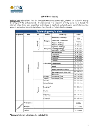
  • 1. OGX Oil & Gas Glossary Geologic time: Span of time since the formation of the oldest earth´s rocks, and that can be studied through the analysis of the geologic record. It is represented by a succession of rocky layers and is divided into intervals whose limits were established on the basis of significant geological events identified around the world. It is organized hierarchically in Super-Eons, Eons, Eras, Periods, Epochs and Ages. Table of geologic time SuperEon Eon Era Period Epoch/Age Years 10 thousand until Holocene (Quaternary) (Tertiary and Quaternary) today 1,6 million – 10 Neogene Pleistocene (Quaternary) thousand Cenozoic Pliocene (Tertiary) 5,3 – 1,6 million Miocene (Tertiary) 23 – 5,3 million Oligocene (Tertiary) 34 – 23 million Paleogene Eocene (Tertiary)* 56 – 34 million Paleocene (Tertiary) 65 – 56 million Maastrichtian* 72 – 65 million Campanian 83 – 72 million Santonian* 87 – 83 million Coniacian 89 – 87 million Turonian 94 – 89 million Mesozoic 100 – 94 million Cretaceous Cenomanian* Phanerozoic 112 – 100 million Albian* Aptian/Alagoas (local age)* 125 – 112 million Barremian/Jiquia (local age)* 130 – 125 million Neocomian 146 – 130 million Jurassic Late/Middle/Early 200 – 146 million Triassic Late/Middle/Early 250 – 200 million Permian 299 – 250 million Carboniferous 359 – 299 million Devonian* 416 – 359 million Paleozoic Silurian 443 – 416 million Ordovician 500 – 443 million Cambrian 542 – 500 million 2.5 billion - Proterozoic 542 million n ia br Archean 4.0 - 2.5 billion am ec Pr Hadean 4.6 – 4.0 billion *Geological intervals with discoveries made by OGX. 1
  • 2. Basic Composition of the Petroliferous System Source rock: Sedimentary rock with a high content of organic matter that, under ideal burial conditions (temperature and pressure), can generate hydrocarbons. Migration: After generation, hydrocarbons are expelled from the source rock and pass through porous/permeable pathways and/or faults/fractures in the rocks towards the surface, and may encounter a trapped reservoir to form an accumulation or, if they do not encounter barriers, may continue up to the surface, forming exsudations (seeps). Reservoir Rock: Sedimentary rock that is sufficiently porous and permeable to store and permit the drainage of fluids contained in its pores. The main reservoir rocks are sandstones, made up predominantly of grains of sand (quartz) and limestones (or carbonates) that are composed primarily of the mineral calcite, which can originate from the remains (carapaces and skeletons) of living organisms or from chemical precipitation. Trap: Traps are combinations of reservoir and sealing rocks, arranged in structures or other geological features allowing the accumulation of oil or gas. Traps are capable of imprisoning petroleum after its formation and migration, preventing it from escaping to the surface. Sealing rock or seal: Sealing rocks are impermeable rocks such as shales, marlstones and evaporites, capable of blocking the passage of petroleum during migration. The effectiveness of the Sealing rocks depends on its thickness and extent. Timing: Occurrence in the appropriate relative time of all the petroleum system elements and processes (source rocks, generation, migration, reservoir rocks/sealing rocks and trapping), allowing the accumulation of petroleum and/or natural gas. When source rocks begin to form petroleum and/or natural gas, and migration begins, reservoir rocks and sealing rocks should already be deposited and arranged in traps to allow the petroleum generated and migrating upwards to be imprisoned to form an accumulation. Technical terms ANP (Agência Nacional do Petróleo, Gás Natural e Biocombustíveis) – National Agency of Petroleum, Natural Gas and Biofuels: Created by Decree nº 2.455, of January 14, 1998, it is the regulatory agency for the activities of the oil and natural gas industry and the biofuels industry in Brazil. 2
  • 3. API Gravity of the American Petroleum Institute (ºAPI): A way of expressing the relative density of an oil or oil product. The API scale, measured in degrees, varies in inverse proportion to the relative density, that is, the greater the relative density, the lower the API degree. The API degree is higher when the petroleum is lighter. Oils with an API degree higher than 30 are considered light; API degrees between 22 and 30 are medium; and below 22 degrees, heavy; an API degree equal to or less than 10 indicates extra-heavy oils. The higher the API degree, the greater the value of the oil in the market. Barrel (bbl): Unit of volume equivalent to 158.98 liters. Barrel of oil equivalent (boe): Frequently used to compare gas with oil and to provide a common approximate measure for different quality gases, for example: 3 3 1,000 m of natural gas = approximately 1 m of oil equivalent = approximately 6.29 barrels of oil equivalent 3 6,000 cf of natural gas = approximately 0.17 m of oil equivalent = approximately 1 barrel of oil equivalent Block: Part of a sedimentary basin, whose boundaries are defined by the regulatory authority, in which oil and natural gas exploration and production activities are performed. According to the ANP definition, a block consists of a vertical prism of indeterminate depth, with a polygonal surface as defined by the geographic coordinates of its vertices. Crude: Crude oil. Depletion: A decline in reservoir pressure that can be detected during a formation test or as a result of the production of oil and/or gas of the reservoir of an oil field. Downstream: The petroleum industry is usually divided into two major components: Upstream and Downstream. Downstream operations and activities refers to the refining of crude oil, and the selling and distribution of natural gas and products derived from crude oil, including liquified petroleum gas (LPG), gasoline or petrol, jet fuel, diesel oil, other fuel oils, asphalt and petroleum coke. The downstream sector includes oil refineries, petrochemical plants, petroleum products distribution, retail outlets and natural gas distribution companies. Farm-in/Farm-out: Process of partial or total acquisition or sale of concession rights held by a company. Within a single transaction, a company that is acquiring the concession rights is in the process of Farming-in and a company that is selling the concession rights is in the process of Farming-out. Field: Area in a sedimentary basin where the existence of reservoirs containing volumes of commercially producible petroleum has been demonstrated by exploration activities (seismic acquisition and interpretation, exploration and appraisal wells, etc). A field is a commercial accumulation of oil and/or gas, consisting of a reservoir or group of reservoirs in subsurface. Horizontal well: A well that starts off being drilled vertically but which is eventually deviated to become horizontal (or near horizontal) in order to run parallel and inside the reservoir containing oil or gas, allowing production rates many times greater than that from a vertically drilled well. Production is greater in horizontal wells mainly due to the larger area of exposure of the oil/gas reservoir to the wellbore (for example: 50 meters of reservoir in a vertical well and 1,000 meters in horizontal wells). Hydrocarbon: Organic compound consisting entirely of hydrogen and carbon. Oil and natural gas are examples of hydrocarbons. 3
  • 4. Net pay: Part of the oil column, comprising only the interval or the sum of intervals of reservoir rocks saturated by oil and/or gas. It is defined by criteria such as porosity, permeability and minimum hydrocarbon saturation. Offshore: refers to oil and gas activities in the continental shelf, in the oceans. Oil: Hydrocarbons can be found in 3 states: liquid, solid and gaseous. Oil is in a liquid state under original reservoir conditions and remains liquid under surface pressure and temperature conditions. Oil/Gas Column: In a well, a continuous vertical section of rocks saturated with oil and/or natural gas, comprising both reservoir and non-reservoir rocks. Onshore: Refers to oil and gas activities in the continent, inland. PEM (Minimum Exploratory Program): “Minimum Exploratory Program” means the work program (involving seismic surveys, wells, etc.) offered by the oil companies for each block in the ANP auctions, as part of the bid offer, together with Signature Bonus and Local Content (% of local services and equipment), to be mandatorily accomplished by the Concessionaire within the Exploration Phase. Subsequently PEM is authorized in Work and Investment Programs (PAT/OAT – Annual Work Program / Annual Budget Program), and must be carried out by Concessionaires during the Phase of Block Exploration. Probability of geological success (Pg): Probability of discovering a commercial accumulation of oil and/or natural gas. Pg is estimated by the product (multiplication) of the probabilities or chances of occurrence of each one of the geological factors: generation, migration, reservoirs, trapping, seal and timing. Prospect: A geological feature mapped as a location or probable location of a commercial oil and/or gas accumulation. A Prospect is defined as a result of geophysical and geological studies allowing the identification and quantification of uncertainties, probabilities of success and estimates of potential resources and economic viability, and so, justifying the drilling of exploratory wells. Prospective Resources: Estimated volumes of petroleum in a prospect, prior to drilling and discovery, and that would be potentially recoverable commercially through future development projects. Total Risked Prospective Resources: Total Prospective Resources multiplied by the Probability of Success. Net Risked Prospective Resources: Total Risked Prospective Resources multiplied by the Company share, that is, excluding the share of the Company’s partners. Contingent Resources: Estimated volumes of petroleum and/or natural gas in an already discovered accumulation, but that require further analysis and/or assessment and/or acquisition/processing of data and/or new technology to be considered commercially producible. Reserve: Volumes of petroleum and/or natural gas already discovered that are commercially recoverable through development projects to be executed starting on a given date. The reserves may be Proven, Probable or Possible, depending on the degree of precision/certainty of the estimate of their volume and the capacity for extraction based on the application of technology, known and/or to be developed. Proven Reserves (P1): Reserves of oil and natural gas that, based on the analysis of geological and engineering data, are estimated to be commercially recoverable with a high degree of certainty. The estimation takes into consideration the applicable economic conditions, the usually viable operating methods and regulations established by petroleum and tax legislation of the country where the reservoirs are located. 4
  • 5. Probable Reserves (P2): Reserves of oil and natural gas for which the analysis of geological and engineering data indicate a greater degree of uncertainty regarding their recovery when compared to estimates of proven reserves. Possible Reserves (P3): Reserves of oil and natural gas for which the analysis of geological and engineering data indicate a greater degree of uncertainty regarding their recovery when compared to estimates of probable reserves. Total Gas Units (UGT): These are measurements taken by devices called “Gas Detectors” during the drilling of oil wells, reporting the total quantity of gas (light and heavy gases) emanating from rocky layers as they are being drilled. Usually detectors provide measurements of total gases (UGT’s) and also estimate heavy gases (UPP’s). Detectors are indispensable devices in the drilling of oil wells, at the same time making it possible to obtain information on the potential of the prospect being drilled and to take additional safety measures during the drilling of the well. Upstream: Concerning to the Exploration, Development of Production and Production activities, comprising the search, appraisal, development and production of oil and/or natural gas. Usually Upstream activities include transport of oil and/ or gas from the producing well to a delivery point that can be a Tanker close to the producing rigs or a pipeline to a Downstream Terminal. Water depth: Distance between the surface of the water and the bottom of the sea. Seismic: Among other exploration technologies the seismic method is by far the main and most utilized one. Consists basically in an energy (sound) source and receivers. 1) Signals are transmitted from the source down into the rock layers; 2) some of the energy is reflected in the interfaces between different rock layers; 3) reflected signals are collected by receivers and 4) transformed by computers in images reflecting the distribution and other properties of the rock layers in subsurface. Composition, fluid content, extent and geometry are some of the rock attributes that can be extracted from the seismic data. 2D Seismic: Data is acquired through a grid of straight lines spaced generally 1-2 km (or more) from each other providing a poor coverage of the subsurface geology, used nowadays mostly for regional studies in a sedimentary basin. 2D seismic reveals only strips of informations. 3D Seismic: 3D seismic imaging provides information almost continuously through the subsurface, in a high density grid of points of data, resulting in much better and precise definition of the subsurface geology. Spacing between points of 3D data is of some meters instead of kilometers as in the 2D seismic, providing a significantly greater amount of information, allowing for a three-dimensional view of the rock layers in the subsurface. REPETRO (Regime Aduaneiro Especial de Exportação e Importação): Special Customs Regime for the Export and Import of equipments to be used in the exploration and production of oil and natural gas. Royalties: Royalties constitute the financial compensation owed to the State by oil and natural gas producing concessionaire companies in Brazilian territory, and they are distributed to the States and Municipalities, the Navy, the Ministry of Science and Technology and the Special Fund administered by the Ministry of the Treasury, which transfers funds onto states and municipalities based on criteria established in specific legislation. 5
  • 6. Royalties, which are assessed on the basis of the monthly production of the producing field, are submitted monthly by the concessionaire companies in the form of payments made to the Secretary of the National Treasury (STN – Secretaria do Tesouro Nacional), up until the last day of the month following the month in which the production occurred. Special Participation: Extraordinary financial compensation owed by concessionaires for the exploration and production of oil or natural gas, in cases of large production volume or high profitability, in accordance with the criteria established in Decree 2.705/98. Reservoir tests Cable Test: This is a mini-test of the formation and comprises part of the process of well profiling as samplers are lowered by cable. Used to verify/assess pressure and collect/identify small amounts of fluids for a small interval of reservoir rocks, almost immediately. It is a quick method that makes it possible to get advance information on fluid, pressure and the permeability of the rock reservoir. Coring: A continuous operation for sampling the rocks in the well which are brought to the surface for analysis by geologists. A great deal of information concerning rock characteristics is obtained: rock type, porosity, permeability, hydrocarbon levels, fractures, etc. Drill Stem Test (DST): A method used to verify/assess the reservoir parameters and production capacity of a given reservoir or part of the reservoir in a particular well. It makes it possible to characterize, among other data and information, fluid type, pressures, permeability, transmissibility and productivity. Extended Well Test (TLD): These are formation tests of longer duration than conventional tests, with total flow times greater than 72 hours, performed during the Exploration Phase, for the exclusive purpose of obtaining data and information to find out about the behavior of the reservoir and fluids during production. Logging (wireline logging / logging while drilling): Method used to verify/assess the physical and chemical characteristics of geological layers and the fluids contained in them, through the use of appropriate sensors and samplers. These characteristics are measured and the responses are transmitted to computers on the surface where the data are processed. Characteristics of fluids and rocks are identified and quantified using this method. Side well core sampling: This operation consists in sampling mini-coring of rocks from open hole wells. It comprises part of the process of well logging and is operated using Samplers/percussion guns that descend well by cable. It is used to obtain information regarding the characteristics of the rock, such as rock type, porosity, permeability, hydrocarbon levels, fractures, etc. It is a quick method that makes it possible to get advanced information on rocks and the levels of fluids contained in them. Other terms AHTS (Anchor Handling Tug Supply): Tow vessel for support and handling of anchors. A vessel intended for the towing and handling operations of anchors using a winch specially installed on its deck, endowed with considerable maneuverability, as well as a high degree of static traction. Christmas Tree: Set of valves controlling the pressure and flow of a well. 6
  • 7. Fixed platform: These are platforms made up of modular structures, installed at the operating site on structures called jackets which are held in place on pilings driven into the sea bottom. FPSO (Floating, Production, Storage & Offloading): Floating Unit for Production, Storage and Offloading of petroleum, built as an extension of a ship. FPU (Floating Production Unit): Floating Unit for petroleum production, built as an extension of a ship. FSO (Floating, Storage & Offloading): Floating Unit for Storage and Offloading of petroleum, built as an extension of a ship. FSV (Fast Supply Vessel): Fast vessel for delivering cargo and passengers. Jacket: Support structure for a fixed platform that goes from the bottom up to above the sea surface, and on which are installed the deck and/or modules where the processing unit and utilities are located. OSRV (Oil Spill Recovery Vessel): A vessel for combating oil spills endowed with specifications that allow it to work within the oil slick, in an atmosphere where the evaporation of petroleum produces natural gas, and for this reason it is equipped with shielded electrical systems to prevent spark creation. It has equipment to vacuum up spilled oil and store it in a tank on board. Oil spill fighting capacity can be created in a PSV (Platform Supply Vessel) or AHTS (Anchor Handling Tug Supply). PSV (Platform Supply Vessel): A vessel for supplying materials to platforms characterized by a large deck area for the transport of equipment, as well as liquids such as drinking water, diesel oil, industrial water, muds and bulk solids; cement, barites and bentonite, etc. Rig: Equipment used for drilling. Self-elevating platform (Jack-up): Maritime platform with three or more legs of variable size and shape that can be positioned at different depths, placing its legs on the sea bottom, raising itself above the sea surface. Semi-submersible platform or rig: These are maritime platforms consisting of a structure of one or more decks, supported by submerged flotation units. TLWP (Tension Leg Wellhead Platform): These are floating platforms used in deep waters, held in place at the operating site by taut legs, intended to support a dry completion wellhead, and may or may not have a drilling and completion tower. Wet Christmas Tree: Set of valves placed under the seabed, controlling the pressure and flow of a subsea well. WHP (Well Head Platform): These are platforms made of modular steel structures installed at the operating site on structures that are called jackets, held by pilings driven into the sea bottom, in shallow water, intended to support dry completion wellheads, and may or may not have a drilling and completion tower. 7