NISAR NASA-ISRO Synthetic Aperture Radar (NISAR) Marine Hazards
•
0 recomendaciones•5 vistas

NISAR Marine Hazards NASA National Aeronautics and Space Administration NASA-ISRO Synthetic Aperture Radar (NISAR) By Dr. Pankaj Dhussa

Recomendados
Recomendados
Más contenido relacionado
Similar a NISAR NASA-ISRO Synthetic Aperture Radar (NISAR) Marine Hazards
Similar a NISAR NASA-ISRO Synthetic Aperture Radar (NISAR) Marine Hazards (20)
Más de Dr. Pankaj Dhussa
Más de Dr. Pankaj Dhussa (20)
Último
Último (20)
NISAR NASA-ISRO Synthetic Aperture Radar (NISAR) Marine Hazards
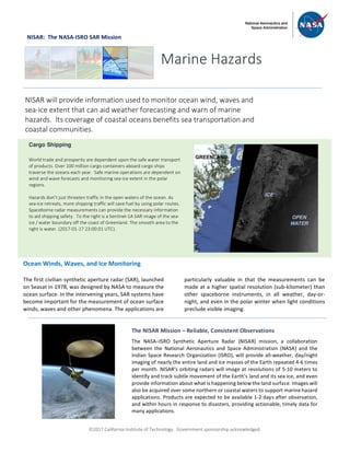
- 1. ã2017 California Institute of Technology. Government sponsorship acknowledged. NISAR: The NASA-ISRO SAR Mission Ocean Winds, Waves, and Ice Monitoring The first civilian synthetic aperture radar (SAR), launched on Seasat in 1978, was designed by NASA to measure the ocean surface. In the intervening years, SAR systems have become important for the measurement of ocean surface winds, waves and other phenomena. The applications are particularly valuable in that the measurements can be made at a higher spatial resolution (sub-kilometer) than other spaceborne instruments, in all weather, day-or- night, and even in the polar winter when light conditions preclude visible imaging. Marine Hazards NISAR will provide information used to monitor ocean wind, waves and sea-ice extent that can aid weather forecasting and warn of marine hazards. Its coverage of coastal oceans benefits sea transportation and coastal communities. Cargo Shipping World trade and prosperity are dependent upon the safe water transport of products. Over 100 million cargo containers aboard cargo ships traverse the oceans each year. Safe marine operations are dependent on wind and wave forecasts and monitoring sea-ice extent in the polar regions. Hazards don’t just threaten traffic in the open waters of the ocean. As sea-ice retreats, more shipping traffic will save fuel by using polar routes. Spaceborne radar measurements can provide the necessary information to aid shipping safety. To the right is a Sentinel-1A SAR image of the sea- ice / water boundary off the coast of Greenland. The smooth area to the right is water. (2017-01-17 23:00:01 UTC). The NISAR Mission – Reliable, Consistent Observations The NASA–ISRO Synthetic Aperture Radar (NISAR) mission, a collaboration between the National Aeronautics and Space Administration (NASA) and the Indian Space Research Organization (ISRO), will provide all-weather, day/night imaging of nearly the entire land and ice masses of the Earth repeated 4-6 times per month. NISAR’s orbiting radars will image at resolutions of 5-10 meters to identify and track subtle movement of the Earth’s land and its sea ice, and even provide information about what is happening below the land surface. Images will also be acquired over some northern or coastal waters to support marine hazard applications. Products are expected to be available 1-2 days after observation, and within hours in response to disasters, providing actionable, timely data for many applications.
- 2. ã2017 California Institute of Technology. Government sponsorship acknowledged. Continued from front page The basics of ocean imaging are readily understood. SAR systems can create images of the ocean surface at incident angles between 20 to 50 degrees. At these angles, a smooth ocean surface will reflect much of the radar energy away from the radar so that the water appears very dark. However, when waves and ripples are present, more energy is reflected backwards. The backscattered energy, and consequently image brightness, increases with the ocean surface roughness. Thus, physical processes that affect ocean surface roughness, such as winds blowing over the ocean, can be measured by SARs. It is known from both theoretical studies and empirical measurements that the image brightness increases with wind speed. This relationship has made it possible to measure ocean surface wind speeds at 500 m resolution. The National Oceanic and Atmospheric Administration (NOAA) can use NISAR data to provide wind speed measurements in coastal areas as the images become available. These images will help form high- resolution wind speed climatologies that can aid in assessing the placement of offshore wind power turbines. Ocean surface waves are also visible in SAR images. Wave crests are slightly rougher than wave troughs, making the undulations of surface waves visible. NISAR will provide images of the ocean surface at 50-m resolution so that the ocean surface waves, which are generally 100-300 m from peak to peak, will be visible. These too will help in understanding high-resolution wave climatologies, particularly in coastal areas. SAR imagery over the Arctic is also useful in determining sea-ice extent. SAR images over ice show the details of ice floes. NISAR will also be particularly useful in discriminating between new ice and generally thicker multi-year ice. NOAA regularly provides composites of a day’s worth of ESA’s Sentinel-1 SAR imagery to the U.S. National Ice Center, where analysts use the SAR imagery to identify sea-ice hazards to navigation. NOAA can also use NISAR data to help understand the dynamics of ice formation and motion. National Aeronautics and Space Administration For more information, visit http://nisar.jpl.nasa.gov/applications Jet Propulsion Laboratory / California Institute of Technology / Pasadena, California / www.jpl.nasa.gov Both empirical measurements and electromagnetic theory bear out the relationship between radar image brightness and wind speed over the ocean. The brightness increases with wind speed and is higher when the wind is blowing towards or away from the radar imaging direction, and lower for wind directions perpendicular to the imaging direction This relationship makes it possible to measure ocean surface wind speeds at 500-m resolution. In this way, the transition between open ocean wind conditions and those near the coast can be resolved. The NISAR mission will provide the U.S.’s first Earth observing spaceborne synthetic aperture radar since the Shuttle Radar Topography Mission (SRTM). The mission is designed to operate for at least three years, providing images of land and coastal oceans that agencies, such as NOAA, can translate into information products to support safe ocean transit and marine hazard response. The radar cross section, or brightness, of a synthetic aperture radar (SAR) image can be related to wind speed. Above is an image of wind speed over the Alaskan Peninsula derived from Sentinel-1B SAR data. The various wind speeds are represented as different colors. NISAR will be able to provide similar wind speed measurements in coastal areas. NOAA regularly generates wind speed products using available SAR data, and NISAR will augment the available information, particularly along U.S. coasts. Radar Measurements of Winds & Waves