1. Case Study: The Yorkshire Coastline
Your case study will include annotated and labelled maps, annotated and
labelled diagrams discussion, photographs, tracing overlays and any other
useful method of explaining the information. Geography in Focus has
some excellent pictures you could annotate your work with.
WHAT DO YOU NEED TO INCLUDE IN YOUR CASE STUDY FILE
1. The are the main direction(s) of the prevailing wind
2. The fetch of the waves
3. The areas of coastline exposed to erosion
4. The areas of coastline exposed to transportation
5. The areas of coastline exposed to deposition
6. The geology of the coastline
7. The landforms created from erosion (inc. stacks, headlands and bays, and coves wave-
cut platform)
8. The landforms created from deposition (inc spit)
9. ‘Focus Files’ (i.e. detailed work) on each of the following
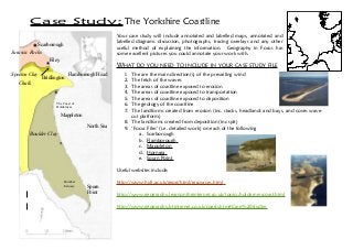
a. Scarborough
b. Flamborough
c. Mappleton
d. Hornsea
e. Spurn Point
Useful websites include:
http://www.hull.ac.uk/geog/html/resources.html
http://www.geography.learnontheinternet.co.uk/topics/holdernesscoast.html
http://www.geography.btinternet.co.uk/coasts.htm#Case%20studies
North Sea
Scarborough
Filey
Flamborough Head
Bridlington
Mappleton
Spurn
Point
Humber
Estuary
The Coast of
Holderness
Boulder Clay
Chalk
Jurassic Rocks
Speeton Clay