SlideShare una empresa de Scribd logo
1 de 15
SHEET NO.
1
NAME – PRAVEEN MUKATI
SCHOLAR. NO. - 141109029
B PLAN THESIS
SUB. CODE: PLA 424
INTRODUCTION
MAULANA AZAD NATIONAL INSTITUTE
OF TECHNOLOGY, BHOPAL
DEPARTMENT OF PLANNING AND
ARCHIETECTURE
Scope Of Study
Aim
“Enhance the share of public space along the riverfront in hoshangabad city.”
Objectives
• To identify the potential land for the public space along the river in hoshangabad city.
• To identify the laws, act, guidelines and policies which helps to developed the public space for
the identified land.
• To identify the type of public activities considering the environment sensitivity of the that
place.
• Identify the suitable recreational facilities to be proposed on the developed land.
• To suggest planning interventions for conservation and protection.
The Research Question
• The scope of this includes the physical proposals along Narmada river , a layout plan and a detailed
out plan of public spaces in the study area.
• Hoshangabad has good tourism scope that helps to focus on the aesthetic value of river Narmada in
Hoshangabad city
• It helps to increase the percentage of recreational landuse on existing landuse.
Limitations
• The study is limited to the Hoshangabad municipal boundary.
• Public activities cannot be extended due to protection of riparian zones.
• Residential area is not considered in the plan
“Development of public space along river Narmada- a case of hoshangabad city”
Thesis Title Methodology
Understanding the problem
Global Context
Indian Context
Formulation of Aim, Objective,
Scope and Limitation
Literature Review
Understanding RFD and
role of public spaces
Type and Successful
element of RFD
acts, laws and
legislations governing
the RFD
Case Study
Indian Case Studies
International Cade Studies
Data Collection
Analysis of the Areas
Identification of potential land for Riverfront
development in Hoshangabad city
Questionnaire analysis
and survey for the
parking along Ghats
Land use cover, Land
Ownership ,Type of
activities along river
Ward density , vegetation
cover, Drainage pattern,
parking
Identification of RFD
strategies
Policy Interventions Physicals Intervention
Primary data- visual survey, Land use
survey, parking survey,questionaire
Secondary data-data collection from
TNCP Bhopal, Collectorate
Hoshangabad, Hoshangabad municipal
corporation, commissioner land records
and settlement MP
Identification of
issues and problems
Lack of Utilization of
land, soil erosion, lack of
aesthetics, solid waste,
degradation of riparian
vegetation
• What are the factor responsible for the development of public space?
• What are the measures, policies, and practices which governing the riverfront development?
• What are factors which helps the city to rejuvenate urban life and space through facilitating
recreational and cultural activities ?
“In general, a riverfront is the zone of interaction between urban development’s and the water and a
riverfront area is considered as a unique and irreplaceable resource where it is the interface between land,
water, air, sun and productive plants. Moreover, the riverfront is characterized as a place integrating land
with water and having a natural attraction to people
Definition
Riverfront
Public space
Examples include spaces such as plazas, town squares, parks, marketplaces, public commons and malls,
public greens, piers, special areas within convention centers or grounds, sites within public buildings,
lobbies, concourses, or public spaces within private buildings.
Definition of riverfront by different scholars
Redevelopment of industrial riverfronts with public-private partnership models can be a way to utilize
existing urban riverfronts, and transform them into an inclusive public space
Types of riverfront
guo (1998) as cited in dong (2004, p. 7)-A more detailed definition by guo (1998) as cited in dong
(2004, p. 7) described the riverfront as the interface point where land and water meet, between
approximately 200 to 300 meters from the water line and 1 to 2 km to the land site and also takes in land
within 20 minutes walking distance.
wu & gao, 2002, as cited in dong (2004, p. 7- It is an integrated system consisting of multiple features,
of which the water forms the center, and enclosed by substantial objects , added the riverfront area should
have multiple features which incorporate each other and surrounded by structural and nonstructural
objects to form a focal point
Breen & rigby as cited (1996, p.5 ) assign developed riverfronts into six distinct groups: commercial
riverfronts; cultural, educational and environmental riverfronts; historic riverfronts; recreational
riverfronts; residential riverfronts; and working riverfronts
Goodwin (1999) argues that waterfront boundaries are difficult to determine and in some instance
planning efforts might focus on a small part of a larger indistinct waterfront area. He presents that “The
concept of a waterfront district helps to identify distinct nodes of revitalization activity within long urban
shoreline reaches”
Dong (2004) cites vellaga (2001) to discuss how cities now have turned to an array of regulatory tools
(zoning, design guidelines and development agreements) to overcome financial hurdles to acquire new
lands for public amenities.
A public space may be a gathering spot or part of a neighborhood, downtown, special district, waterfront,
or other area within the public realm that helps promote social interaction and a sense of community.
• The Natural Waterfront, comprising beaches, wetlands, wildlife habitats, sensitive ecosystems
and the water itself.
• The Public Waterfront, including parks, esplanades, piers, street ends, vistas and waterways
that offer public open spaces and waterfront views.
• The Working Waterfront, where water dependent, maritime and industrial uses cluster or
where various transportation and municipal facilities are dispersed.
• The Redeveloping Waterfront, where land uses have recently changed or where vacant and
underutilized properties suggest potential for beneficial change.
Trend of riverfront development
1960s - massive riverfront development began and consequently initiated the world-wide era of
riverfront revitalization.
1970s - urban riverfront redevelopment bloomed,
1980s - accelerated and continued in the future.
SHEET NO.
2
NAME – PRAVEEN MUKATI
SCHOLAR. NO. - 141109029
B PLAN THESIS
SUB. CODE: PLA 424
LITERATURE REVIEW
MAULANA AZAD NATIONAL INSTITUTE
OF TECHNOLOGY, BHOPAL
DEPARTMENT OF PLANNING AND
ARCHIETECTURE
Elements of successful riverfront development
elements of
successful river
front
development
effective
managem
ent
begining
the
project
financial
faesibility
environm
ental
approval
constructi
on
technolog
y
authencit
y
function
project
theme and
image
public
perceptio
n of need
A public space may be a gathering spot or part of a neighborhood, downtown, special district,
waterfront, or other area within the public realm that helps promote social interaction and a sense of
community
Importance of Public space in riverfront
• coordinate the water usage and supporting land base to maximize the economic, recreational
and environmental asset of water bodies
Characteristics of public spaces
• Dynamic area- Riverfront zone is a dynamic area with frequently changing biological, chemical
and general attributes
Special characteristics of riverfront
• Habitat- Riverfront zone include highly productive and biologically diverse ecosystems that offer
crucial nursery for many species
• Natural defence-Riverfront zone features such as mangrove forests serves a critical natural
defense against natural hazards
• Pollution moderator- Water ecosystem may act to reduce impacts of pollutions originating from
land such as wetland absorbing excess nutrients , sediments, human waste.
• Establish a water’s edge that is continuous, publicly accessible and magnificent.
• create a network of public spaces that attract and invite both localities and tourists to riverfront.
• require design excellence for riverfront public spaces. Provide a wide-range of public spaces that
foster culture and creativity in our city.
• ensure all public spaces adhere to a high environmental standard.
• strengthen connections along the riverfront on both sides of the river
• improve the aquatic habitat and water quality along the riverfront and integrate them with river
and stream improvements.
• maintain a consistency in riverfront design elements in all public spaces (i.e. Park benches and
lamp posts).
Various Act, laws, policy and guidelines governs riverfront development
Environmental protection act
1986
The Constitution of India also provides for the protection of the
environment. Article 48A of the Constitution specifies that the
State shall endeavor to protect and improve the environment and
to safeguard the forests and wildlife of the country. Article 51 A
further provides that every citizen shall protect the environment.
• develop strong link between existing communities and emerging riverfront communities and
spaces
SHEET NO.
3
NAME – PRAVEEN MUKATI
SCHOLAR. NO. - 141109029
B PLAN THESIS
SUB. CODE: PLA 424
LITERATURE REVIEW AND ACT,
GUIDELINES AND POLICIES
MAULANA AZAD NATIONAL INSTITUTE
OF TECHNOLOGY, BHOPAL
DEPARTMENT OF PLANNING AND
ARCHIETECTURE
Guidelines for the Preparation of Urban River
Management Plan for all Class II Towns in
Ganga/Narmada River Basin 2010
1. Removal of encroachments and land
acquisition for riverbank beautification and
related development works.
2. Restriction/banning of certain activities on the
riverbank or in the river, viz., open defecation,
disposal of solid waste, washing of clothes,
wallowing of cattle, throwing of floral offerings,
disposal of corpses, routine bathing (as opposed
to ritual bathing), etc.
3. Development/restoration of the riverbank
area, i.e., construction / restoration of ghats,
provision of public baths and toilets,
construction of walkways, parks, other public
spaces, access roads, commercial
establishments, etc.
Riverfront guidelines by MoEF Type a – area development plans (adp) would
apply to sub-projects where larger river front
Stretches say 1-2 km long and 30-40 m wide are
involved. Facades of rfd works must be match
with the cultural, religious and heritage value of
the place. Given the meandering characteristic
of most rivers, one of the essential requirements
should be the availability of water along the
bank round the year.
SHEET NO.
4
NAME – PRAVEEN MUKATI
SCHOLAR. NO. - 141109029
B PLAN THESIS
SUB. CODE: PLA 424
ACT, GUIDELINES AND POLICIES
MAULANA AZAD NATIONAL INSTITUTE
OF TECHNOLOGY, BHOPAL
DEPARTMENT OF PLANNING AND
ARCHIETECTURE
Guidelines for the Preparation of Urban
River Management Plan for all Class II
Towns in Ganga/Narmada River
Basin 2010
1. Removal of encroachments and land acquisition for
riverbank beautification and related development works.
2. Restriction/banning of certain activities on the riverbank
or in the river, viz., open defecation, disposal of solid waste,
washing of clothes, wallowing of cattle, throwing of floral
offerings, disposal of corpses, routine bathing (as opposed
to ritual bathing), etc.
3. Development/restoration of the riverbank area, i.e.,
construction / restoration of ghats, provision of public baths
and toilets, construction of walkways, parks, other public
spaces, access roads, commercial establishments, etc.
.
A Guide to Riverfront Development
Connecting communities to the water
SMARTNET.NIUA-Riverbanks,
shorelines, riparian buffers, and river
habitat are critically important when
planning any riverfront project.
 The riparian buffer should be no less than 10-20 metre at
its narrowest, with three zones of buffer from the stream
edge inland.
 Provide a minimum walkway width of 10-15 feet for
perpendicular connections
 Connections should be accessible to the public even
when they are adjacent to private development.
 Riverfront trails should be simple and integrated with the
landscape and defined by the vegetation of the park
 Promenades should be 15-20 feet and along with 3-5 feet
tree range , a riverfront park should be considered part of
the park.
 Retaining wall must be.5-1metre of width along with
promenade of 5-10metre
 Perpendicular Connections- Provide a minimum
walkway width of 12 feet for perpendicular connections
to be maintained as an easement or public right-of-way.
Provide a minimum setback for all structures, including
fences, of 10 feet on either side of the connection.
Water(prevention and control
of pollution)1974
The act aims to prevent and control water pollution and to
maintain/restore wholesomeness of water by establishing central
and state pollution control board to monitor and enforce the
regulations.
Biological Diversity Act,
2002
. Article 48A of the directive principles of state policy declares:
“the State shall endeavor to protect and improve the environment
and to safeguard the forests and wild life of the country”.
‘Fundamental Duties’ as envisaged in Article 51A (g), imposes a
similar responsibility on every citizen ‘to protect and improve the
natural environment including forests, lakes, rivers and wild life
and to have compassion for living creatures.
National green tribunal act
2010
Order of the National Green Tribunal (Central Zonal Bench,
Bhopal) in the matter of Paryavaran Avam Manav Sanrakshan
Samiti Vs. State of Madhya Pradesh & Others dated 09/04/2015
regarding construction near Narmada River with respect to No
Construction Zone and the 30 meter Zone.
National Green Tribunal on Friday lifted the ban on sand mining
in the rivers in Madhya Pradesh.
Narmada valley development
authority of MP
• -to shoulder responsibility of human resettlement and
rehabilitation in respect of projects in the Narmada Valley, to
establish towns and villages and -to take all necessary measures
to ensure planned settlement and rehabilitation;
• -to advise for the proper conservation and development of
forests, wildlife and fisheries in the Narmada Valley;
• -to acquire and manage land in the Narmada Valley for the
purpose of carrying out engineering works, to provide for
human.
• -no construction has to be done 10-15 from the edges of
narmada river
Riverfront guidelines by
MoEF
Type a – area development plans (adp) would apply to sub-
projects where larger river front
Stretches say 1-2 km long and 30-40 m wide are involved.
Facades of rfd works must be match with the cultural, religious
and heritage value of the place. Given the meandering
characteristic of most rivers, one of the essential requirements
should be the availability of water along the bank round the year.
Madhya Pradesh Special
Project & Township
(Development, Regulation &
Control) Rules, 2011
Construction on river 10-20m from Rivers or
lakes/ponds/reservoirs or nalas/canal or flood affected areas
Case studies-Review
Case study 1- Malaysia riverfront development
Waterfront Areas : Kuching Riverfront. Malacca Waterfront, Glenmarie Riverfront
The current pattern of riverfront development in malaysia now focuses more on mixed-use development
and recreation, while incorporating Malaysian cultural and historical values.
Case study areas Kuching riverfront Malacca riverfront Glenmarie riverfront
Name of water body
Sarawak river
Malacca river
Langat river
Type of project Recreational Recreational Recreational
Project’s owner Project’s owner
State of malacca Drb-hicom
Amenities Restaurants, shops,
river access, river
settlement
River access, shops
,riverfront settlements
Restaurants , river
access, housing
Views River views & city River views & city Limited river views
Proximity to river 50m 50m 50m
Proximity to CBD 1km 1km 35km
The main
objective of this
development
proposal is to
strengthen the
commercial and
recreational
activities which
reflects
character, social,
culture and
identity of the
place.
Characteristic of Malaysian riverfront development
Location of Malaysian riverfront development
SHEET NO.
5
NAME – PRAVEEN MUKATI
SCHOLAR. NO. - 141109029
B PLAN THESIS
SUB. CODE: PLA 424
LITERATURE REVIEW- CASE STUDY OF MALAYSIA AND SABARMATI
RIVERFRONT DEVELOPMENT
MAULANA AZAD NATIONAL INSTITUTE
OF TECHNOLOGY, BHOPAL
DEPARTMENT OF PLANNING AND
ARCHIETECTURE
• Make the riverfront accessible to the public
• Stop the flow of sewage, keep the river clean and pollution-free
• Reduce risk of erosion and flooding in flood prone neighborhoods
• Create riverfront parks, promenades and Ghats to enjoy the water.
• Revitalize riverfront neighborhoods, rejuvenate Ahmedabad.
• Generate resources to pay for all of the foregoing.
• Stitch together east and west Ahmedabad.
• Create a memorable identity for Ahmedabad.
Location of Sabarmati riverfront development
This project aims to transform Ahmedabad's historic yet neglected river into a vibrant & vital focus
for the Ahmedabad city.
The development project encompasses both banks of the Sabarmati for a 10.5 kms, stretch,
creating approximately 185 hectares of reclaimed land
Case study 2 Sabarmati riverfront development
Objectives of Sabarmati riverfront development
The Sabarmati Riverfront Project add almost 10,00,000 sq. mts. of parks, promenades and plazas to
Ahmedabad.
 The Sabarmati Riverfront Project help provide Ahmedabad with many new cultural trade and
social institutions (36,000 Sq.m).
 Creating of City Level Recreational Activities – Water Sports and Floating restaurants.
 Tourist attraction.
 Recharge of Ground water Aquifers of the city
 Continuous Green coverage along the river corridor.
 Elimination of Flood Hazard.
• Creating Vibrant Urban neighborhoods and beautification of the city
Case study areas Sabarmati riverfront
Name of water body Sabarmati river
Type of project Recreational
Company Sabarmati river front development corporation limited (srfdcl)
Amenities Restaurants, river access, shops, riverfront settlements, gardens,
walkways, amusement parks, golf course, water sports
Views River views & city
Proximity to river 50m
Proximity to cbd 1 km
Financial sources The project has been planned as a self-financing project. The revenues
would be Generated from the sale of proclaimed land.
Construction period Start on early 2005 & complete on nov 2012
Development area Includes both banks of the sabarmati for a 10.5 kms, stretch, creating
approximately 185 hectares of reclaimed land
Developer Ahmedabad municipal corporation setup special purpose vehicle -
sabarmati riverFront development corporation limited
Consultants Hcp design, planning and management pvt. Ltd
Concept It is an environmental improvement, social and urban rejuvenation
project by Development of riverfront along Sabarmati river in the
commercial capital of state. The objective of the project is to improve
spatial structure and habitat conditions of The river and adjoining areas.
Basically it is an urban renewal project
Inferences from malaysia and Sabarmati riverfront development
Characteristics of Sabarmati riverfront development
Malaysia riverfront
development
1) to help the local vendors in terms of wet market & dry market
2) commercial oriented development
3) recreational development like walkways & yoga mediation center
4) River beautification works
Sabarmati riverfront
development
1) urban reform project
2) flood mitigation works
3) recreational development
4) public space creation
5) slum rehabilitation works
6) groundwater recharge
7) infrastructure development
SHEET NO.
6
NAME – PRAVEEN MUKATI
SCHOLAR. NO. - 141109029
B PLAN THESIS
SUB. CODE: PLA 424
MAULANA AZAD NATIONAL INSTITUTE
OF TECHNOLOGY, BHOPAL
DEPARTMENT OF PLANNING AND
ARCHIETECTURE
LITERATURE REVIEW- CASE STUDY OF MALAYSIA AND SABARMATI
RIVERFRONT DEVELOPMENT
qualities are
listed out in
the riverfront
destinations.
Identity
& image
Flexibilit
y in
design
Diverse
funding
sources
Landuse
managem
ent
Amenitie
s
Access
and
linkage
Edge
uses
Attractio
ns &
destinatio
ns
Qualities obtained from malaysia and Sabarmati riverfront development
Demographic profile of Hoshangabad city
Introduction: Hoshangabad city
• Hoshangabad is about 80
km from Bhopal and is well
connected by both- road
and railways. Itarsi, a major
railway junction, that
connects major towns
across the country, is about
18 kms from Hoshangabad.
• The Narmada, the largest
river flowing through the
city, gives the identity of
holy city.
• Latitude:N22o 46
Longitude: E77o 44
• The town is surrounded by
Khojanpur village in the
north, Neemsadia on the
south, Rajpur on the east
and Deshmehani on the
west.
YEARS TOTAL
POPULATION
TOTAL HH HH SIZE MALE FEMALE CHILD POP
1991 70914 18521 4.91 36364 34550 9954
2001 97424 21578 5.14 50710 46714 11249
2011 117988 24737 5.98 61716 56272 13281
70914
97424
117988
36364
50710
61716
34550
46714
56272
1991 2001 2011
Population of Hoshangabad city
TOTAL POPULATION MALE FEMALE
• Population of Hoshangabad
gradually increased between
1991-2011
• Household size also increased
between 1991-2011
Existing demographic
profile
Location of -Study area Hoshangabad
SHEET NO.
7
NAME – PRAVEEN MUKATI
SCHOLAR. NO. - 141109029
B PLAN THESIS
SUB. CODE: PLA 424
DATA COLLECTION
DEMOGRAPHIC PROFILE HOSHANGABAD CITY
MAULANA AZAD NATIONAL INSTITUTE
OF TECHNOLOGY, BHOPAL
DEPARTMENT OF PLANNING AND
ARCHIETECTURE
Hoshangabad is a class-ii town of Madhya pradesh
Hoshangabad municipality spreads over an extent about 24.27 sq.km and is divided into 33 wards
The population of the town was 117988 as per census 2011. Hoshangabad nagarapalika parishad
has constituted in the year 1867
Hoshangabad is a holy city with roughly about 0.10 to 0.15 million pilgrims visit during the festive
seasons. Such occasions are reported to be almost once every month. Hoshangabad is district and
tehsil headquarter and important agriculture trade centre in the region
Hoshangabad municipality has total administration over 24,737 houses to which it supplies basic
amenities like water and sewerage. It is also authorize to build roads within municipality limits and
impose taxes on properties coming under its jurisdiction.
It comprising of the nine revenue villages khojanpur, rasuliya, jalalabad, malakhedi, kishanpura,
dongri, budhwada, kulamadi and phefarta as shown below in figure 2. Kishanpura is the only
village which is totally inside the municipal area; whereas the other villages have some part inside
the municipal limits
Hoshangabad ward wise population
year No. of households
1991 18521
2001 21578
2011 24737
Between 1991-2011 Households and population of
Hoshangabad increased due to :
• Good tourism in city.
• Extension of municipality area of development
because of good agriculture marketing.
• Literacy rate gradually increased over the decades, In 2011 it was 87.21%
YEARS
TOTAL POPULATION LIT POP LITERACY RATE
1991 70914 50547 71.27
2001 97424 72487 74.40
2011 117988 103108 87.21
YEARS
TOTAL
POPULATI
ON
SC POP ST POP
TOTAL WORK
FORCE
NON WORK FORCE
1991 70914 10586 2425 60524 10390
2001 97424 16255 4421 58765 38659
2011 117988 20350 6938 70942 47046
• Settlement have lower no. of SC and ST population And high no. of non working force.
• Mainly working population is involved in:
• Tourism (Pilgrimage and temple shops)
• Labour (construction in MNREGA)
• Agriculture
14 Ward no - 14 2,886 83.1% 880
15 Ward no - 15 5,446 76.4% 841
16 Ward no - 16 6,684 76% 899
17 Ward no - 17 4,048 82.6% 1,031
18 Ward no - 18 9,009 79.3% 868
19 Ward no - 19 8,131 81.3% 932
20 Ward no - 20 4,402 59.5% 903
21 Ward no - 21 4,794 76.4% 901
22 Ward no - 22 2,011 86.4% 930
23 Ward no - 23 2,532 84% 910
24 Ward no - 24 2,486 73.1% 923
25 Ward no - 25 9,241 83.1% 926
26 Ward no - 26 4,404 65.1% 900
27 Ward no - 27 2,398 75.7% 909
28 Ward no - 28 1,917 78.9% 904
29 Ward no - 29 3,524 76.8% 884
30 Ward no - 30 2,656 79.6% 819
31 Ward no - 31 3,275 74.9% 902
32 Ward no - 32 4,765 71.1% 939
33 Ward no - 33 4,488 65.8% 933
SHEET NO.
8
NAME – PRAVEEN MUKATI
SCHOLAR. NO. - 141109029
B PLAN THESIS
SUB. CODE: PLA 424
MAULANA AZAD NATIONAL INSTITUTE
OF TECHNOLOGY, BHOPAL
DEPARTMENT OF PLANNING AND
ARCHIETECTURE
S no. Ward Population Literacy Sex ratio
1 Ward no - 1 3,084 69.7% 898
2 Ward no - 2 2,054 85.5% 921
3 Ward no - 3 2,048 87.2% 889
4 Ward no - 4 1,969 78.8% 915
5 Ward no - 5 1,535 84.8% 973
6 Ward no - 6 2,356 71.3% 880
7 Ward no - 7 2,230 74.3% 909
8 Ward no - 8 1,767 79.6% 948
9 Ward no - 9 1,907 76.4% 960
10 Ward no - 10 1,355 85.3% 919
11 Ward no - 11 1,695 84.3% 915
12 Ward no - 12 2,343 81.6% 1,048
13 Ward no - 13 4,548 80.8% 934 Ward delineation map
DATA COLLECTION
DEMOGRAPHIC PROFILE HOSHANGABAD CITY
SHEET NO.
9
NAME – PRAVEEN MUKATI
SCHOLAR. NO. - 141109029
B PLAN THESIS
SUB. CODE: PLA 424
DATA COLLECTION-
ANALYSIS OF LANDUSE,TRANSPORTATION AND DRAINAGE OF
HOSHANGABAD
MAULANA AZAD NATIONAL INSTITUTE
OF TECHNOLOGY, BHOPAL
DEPARTMENT OF PLANNING AND
ARCHIETECTURE
Hoshangabad Existing Landuse
58%
4%2%5%
1%
1%
9%
20%
Residential Commercial
Industrial Institutional
Public amenities Recreational
Circulation Ground & parks
Nagarpalika
parishad limits
Nagarpalika
parishad limits
S.No Land use
category
Area in (ha) % to total extent
of town
Extended
area
Total
planning
area
% total planning
area
1 Residential 1248.98 56.76 56.14 1356 58
2 Commercial 24.41 1.11 - 24.41 3.7
3 Industrial 9.74 0.44 - 9.74 1.5
4 Institutional 87.45 3.98 - 87.45 5.49
5 Public amenities 8.1 0.37 - 8.1 1.25
6 Recreational 6.55 0.3 - 6.55 1.01
7 Circulation 59.08 2.69 - 59.08 9.11
8 Vacant land 268.56 12.21 - - -
9 Agricultural land 406.75 18.49 - - 20
10 Water bodies 80.38 3.65 - - -
Total 2200 100 56.14 648.22 100
Hoshangabad Existing Transportation map and drainage pattern of city
The land use under the
transportation is 59.08 ha,
which is 9.11% of the total
existing land-use
. There are four major natural drains – Kori Ghat nallah, Ladiya nallah, Sukh Tawa nallah and Khojanpur
nallah (Sukh Tawa Nallah discharges into Khojanpur nallah) that carry the wastewater for ultimate disposal
into River Narmada
Hoshangabad drainage pattern of city
Ladiya nallah
Sukh Tawa nallah
Khojanpur nallah
Kori Ghat nallah
SHEET NO.
10
NAME – PRAVEEN MUKATI
SCHOLAR. NO. - 141109029
B PLAN THESIS
SUB. CODE: PLA 424
DATA ANALYSIS AND SYNTHESIS OF
IDENTIFIED LAND
MAULANA AZAD NATIONAL INSTITUTE
OF TECHNOLOGY, BHOPAL
DEPARTMENT OF PLANNING AND
ARCHIETECTURE
Introduction to the identified land-Hoshangabad
The stretch for riverfront development has been selected on the basis of potential government land and area
delineated on the basis of ward boundary in which stretch cover 2.78 km of stretch, according to national
river conservation plan & riverfront edge design guidelines ,water prevention and riverfront guidelines
says that no construction 10-15metre from the river because of riparian vegetation after that 5 metre buffer
for the promenade, 15metre buffer has to be allocated for the riverfront development .according to Madhya
pradesh National green tribunal river no construction activities has been allowed 15metre from the river.
River stretch boundary has to be decided on the basis of the ward boundary. Total area of the stretch covers
9.09hecatre of land.
Base map of identified land
Ward delineation map
There are 5 wards in the riverfront area. Stretch which covers the ward no 1,2,3,26 and 27 in which the
population of the five wards is 13988 it consist of 8.4% of total city population.
22%
15%
15%
31%
17%
ward wise % of population
ward no1 ward no 2 ward no 3
ward no26 ward no 27
Ward density map
.The wards 1, 2, 3, 26 and 27 have least density in the range 400-800 pph and are shown in the green
color. Rest of the wards have high density and are shown in the dark green color.wards contains least
density because of this
Land ownership map
Land ownership –ward no. 1, 2, 3, 26 and 27 , which mainly consist of more potential govt. land as
comparatively the other ward, and have least density which shows the scope of development of physical
interventions on the identified land as comparatively other part of Hoshangabad city
1:29100
1:29100
1:29100
1:29100
SHEET NO.
11
NAME – PRAVEEN MUKATI
SCHOLAR. NO. - 141109029
B PLAN THESIS
SUB. CODE: PLA 424
MAULANA AZAD NATIONAL INSTITUTE
OF TECHNOLOGY, BHOPAL
DEPARTMENT OF PLANNING AND
ARCHIETECTURE
Landuse analysis of identified land
37%
28%
33%
2%
Land Use Composition
Residential
Recreation
al
PSP
Roads
Existing Landuse map
• Existing land use pattern of the stretch which mainly consist of semi public spaces, residential
and recreational landuse. The following landuse mainly consist of potential govt. Land on the
basis of ownership map.
• Stretch which covers the ward no 1,2,3,26 and 27 in which the population of the five wards is
13988 it consist of 8.4% of total city population.
Existing condition of area
Stretch which covers the ward no 1,2,3,26 and 27 in which problem faced by the identified land are
as follows-
• Direct disposal of sewage into the Narmada river
• There is no proper utilization of riparian zones and potential land.
• Condition of solid waste management is very poor and unhygienic.
• There is no parking facility for the visitors which causes congestion during occasional fair like
amawasiya and Purnima.
• There was no any formal market has been provided for the vendors and hawkers.
• Lack of public facilities and services like no community toilets, changing room and safety like
CCTV and divers.
• Ladiya nallah which flows through the identified land which mainly occurs durin the monsoon
times .there is no such sewage discharge in identified area
Existing built up map
Ladiya nala
The existing built map consist of 33% and rest 67% of land is still not developed
Which has the scope of development. Non Built map consist of different landuse in green cover and
open land are present. Some of the land came under green cover which can not be developed because of
good vegetation.
1:29100
1:29100
1:29100
DATA ANALYSIS AND SYNTHESIS OF
IDENTIFIED LAND
SHEET NO.
12
NAME – PRAVEEN MUKATI
SCHOLAR. NO. - 141109029
B PLAN THESIS
SUB. CODE: PLA 424
QUESTIONAIRE ANALYSIS AND PEAK
ACCUMULATION SURVEY ANALYSIS SYNTHESIS
MAULANA AZAD NATIONAL INSTITUTE
OF TECHNOLOGY, BHOPAL
DEPARTMENT OF PLANNING AND
ARCHIETECTURE
Questionnaire and peak accumulation survey analysis
13%
25%
34%
28%
Age Group Composition
<15
15_25
25_40
40+
72%
28%
Gender
Male
Female
• Mostly males are visited on the riverfront area of Narmada , which
contains activities like ,religious shopping, swimming and for
education purpose, visitors are more as comparatively the people
visited for workplace. While the females were mostly visited at the
river front area for the shopping because Itwara bazaar located near
the river Narmada.6
10%
25%
34%
26%
3%
2%
Purpose of Visit
Recreational
Religious
Workplace
Shopping
Education
Swimming
• Purpose of the peoples visited on the riverfront area mostly age
group of 40+visited on Narmada river for religious purpose in
which there is absence of which formal shops .there is more scope
of small commercial hub at the riverfront area.
• There was good scope of formal market located on the area.
• Riverfront has the potential of visitors holding but there was no
any such place for visitors resident.
• Mostly peoples visited at that area for jogging, walking and for
mental relaxation at the morning and evening, there is lack of
services and facilities
30%
26%
22%
20%
Problems/ Issues
Congestion
Hygiene
Lack of Public
Services
Safety
•There is lack of public services on the ghat of Narmada
river. There is a scope of public services on the riverfront
area for the visitors.
•Rest of the problem related to safety which can be solved
easily by providing safety related facilities.
20%
20%
15%
10%
22%
13%
Improvements
Solid waste
Management
Aesthetics
Lighting
Security
Parking
Public
Facilities
Encroachmen
t
16%
17%
13%
12%
15%
15%
12%
Facilities Open gym
Meditation and
Yoga Center
Boat club
Food court
Aashram/
dharamshala
Garden and Park
Light Show
•Most of the people want facilities like meditation and yoga centre,
food court on the riverfront area ,people those who visited river for
the religious purpose mostly prefer facilities like mediation yoga
centre ,ashram/dharmsala (parikrama vaasi ).
•People those who visited Narmada river for the recreation
activities like walking and jogging for refreshment ,mostly prefer
open gym at the ghat and also want parks and gardens.
• Most of the peoples from age group of 40+ because people belong to
this category mainly involve with religious activity and has good
scope of tourism.
• Peoples have less opportunity of commercial activities on occasion of
religious fair mostly on poornima and amawasiya .
• Mostly peoples visited on the Itwara bazar for shopping.
•people faces problem of parking at the riverfront area because
of this more congestion occur during the religious fair .there is
scope of parking facilities on the riverfront area.
•problem related to solid waste management on the river front
area there is non availability of services related to waste
management on the Sethani Ghats and on along the river edges
because waste during fair are thrown along the river. Solid
waste management has to be done the riverfront area only along
the river edges.
•people want aesthetic and public facilities on the riverfront area. because there is lack of public facilities
and also want services related to safety
•People also wants garden and parks along the riverfront area. there is scope of gardens and parks on the
riverfront area.
peak accumulation survey analysis at Sethani ghat
SETHANI
GHAT
Parking
Slot
0
20
40
60
80
100
120
09:00:00
09:30:00
10:00:00
10:30:00
11:00:00
11:30:00
12:00:00
00:00:00
13:00:00
13:30:00
14:00:00
14:30:00
15:00:00
15:30:00
16:00:00
16:30:00
17:00:00
17:30:00
vehicles CAR
TWO WHEELER
AUTO/ TEMPO
Problems
• Encroachment due to illegal parking outside the
shops
• Parking in the middle of the road in zone 1. i.e., in
Narmada Ghat.
• Very few park their vehicles in the paid parking area.
• On street parking between two streams.
1:29100
SHEET NO.
13
NAME – PRAVEEN MUKATI
SCHOLAR. NO. - 141109029
B PLAN THESIS
SUB. CODE: PLA 424
PERSPECTIVE AND BENEFIT OF PROPOSAL
PROPOSAL FOR RETAINING WALLAND PROMENADE
MAULANA AZAD NATIONAL INSTITUTE
OF TECHNOLOGY, BHOPAL
DEPARTMENT OF PLANNING AND
ARCHIETECTURE
Perspective behind the proposal plan
Study area Government land
Land for development of
social purpose
Recreation purpose
Without fee
Recreation purpose
With fee
Developed land
Under developed land
Policy for the ghat revitalization
Construction of retaining wall parallel to
promenade
•Boat club
•Informal market
•On street parking for 2w
•Open gym
•Meditation and yoga center
•Ashram/dharmsala
•Garden & water front park
•Light show
•Lower promenade
•Riverfront walkway
•Open air theatre
Proposals Benefits
A Retaining wall  To protect the natural waterfront
 In streamlining the water course
 It will helpful in erosion control
 Helpful in solid waste management
 To prevent the riverfront becoming a dumping site.
B Waterfront park &
lower promenade
 Waterfront Park & footpath: these two elements are running parallel to the river, offers a
unique vista to the people towards water body. Along the river people can walk and do
fishing. This segment along the river will be as active as a public street.
 Along the river footpath will provide direct access to water for boating and fishing.
 It can be the place for social integration
C Boat club zone It will be a children attraction zone, profit/revenue earning, , it will be active recreational
area
D formal market It is a local bazaar for vegetable or fruits sops or vendors.it consist of handicrafts.
E Light show/Open air
theatre
It is proposed along the riverfront for increasing the aesthetic value and for entertainment
purpose of visitors along narmada river.
F Open gym For Gym, equipments available free of cost for the children to old age people
G Ashram/Dharamshala To organized cultural activities & for the parikrma vaasi and for the people visited on fair
H Yoga and meditation
centre
To organize the activities like yoga and for the relief of mind medication centre has been
provided for the peoples those who visited for walk at morning and evening time.
I Parking space There will be parking area for two wheeler vehicles near the Narmada river ghat and along
the informal market and parks &garden.
Recreational activities Proposal and their benefits
Proposal for Retaining wall and promenade
According to MoEF policies and guidelines stretch for the riverfront development
must not be less than 2km, and 10-15 meter area should be no construction zone
because of the presence of riparian vegetation.
The lower promenade must not be less than 15-20feet with the presence of lights,
trees and plantation has been along the lower promenade.
Existing riparian vegetation space
Narmada river
10M no construction
zone
5M lower
promenade
.5M width
Retaining
wall
30M
Proposals
Water level
15-20 M
According to riverfront guidelines
• Retaining wall area along river– 2.78 km
• Retaining wall width- .5metre
• Sethani ghat - .5 km
• Lower promenade area along river-2.28km
• Lower promenade width -5meter (15feet)
Retaining wall
Lower promenade
SHEET NO.
14
NAME – PRAVEEN MUKATI
SCHOLAR. NO. - 141109029
B PLAN THESIS
SUB. CODE: PLA 424
PROPOSAL PLAN FOR
RECREATIONALACTIVITIES
MAULANA AZAD NATIONAL INSTITUTE
OF TECHNOLOGY, BHOPAL
DEPARTMENT OF PLANNING AND
ARCHIETECTURE
Proposed area classification
for recreational activities
Area in metre
square
Riverfront park 5104
Boat club 253
Open gym 4493
Mediation and yoga centre 974
Light show along ghat 390
Ashram/ dharmshala 1156
Informal markets 900
Parking facility 485
Open air theatre 2623
Total area 16378
Proposed stretch for retaining
wall
Area in km
retaining wall 2.78 km
Proposed area for lower
promenade
Area in metre
square
Lower promenade 2.28km 16761
Proposal for recreational activities
Proposal for recreational activities based on the imposition of three Maps in which
density map, land ownership map and built up map Plays an important role. Imposition
three layers identify the most Suitable land for the development of recreational activities
on the Identified area.
Proposal has to be given on the basis of considering the environmental sensitivity of that
place. Proposal consist of both the recreational activities with fee and without fee which
helps for the purpose of social development,
Density map
Land ownership map
Built up map
SHEET NO.
15
NAME – PRAVEEN MUKATI
SCHOLAR. NO. - 141109029
B PLAN THESIS
SUB. CODE: PLA 424
PROPOSAL PLAN FOR
RIVERFRONT WALK
MAULANA AZAD NATIONAL INSTITUTE
OF TECHNOLOGY, BHOPAL
DEPARTMENT OF PLANNING AND
ARCHIETECTURE
Riverfront walkway- The riverfront walkway focuses on
developing a riverfront walk connecting the people with different
recreational activities and provide accessibility to the formal
market, and along with Restoration and Infra development. The
primary focus would be to create enabling infrastructure
interconnecting major recreational activities along the river
Narmada.
Proposed Component
 Strengthening of approach Roads leading to Pilgrimage Assets
along the river
 Beautification of Approach Roads leading to Pilgrimage Assets
along the riverfront Walk.
 Facade restoration of temples along the walk.
 Directional Signage
 Covering of open drains.
 Street lighting inspired by local architecture.
 Seating benches.
 Beautification of walkway
Proposal for riverfront walk
• The guidelines recommended widths of footpaths as per their
carrying capacity in terms of number of persons per hour. The
minimum width of a footpath in the guidelines is suggested to
be 1.5 meters, at places where number of people going in both
directions per hour is less than 800. A footpath of width 4
meters can carry 6,000 persons per hour per in one direction or
4,000 persons in both the directions
• The guidelines illustrated various design elements leading to universal access. It also recommended various lane sizes for Non-
Motorized Transport (NMT) lanes for bicyclists, cycle rickshaws, hand push carts, hawker carts, animal carts etc. It recommended the
minimum acceptable width of NMT lane for single lane movement to be 2.5 metres (p.76)
• The minimum width of a footpath was recommended to be 1.8 metres which allows minimum two people to cross each other
comfortably. The footpath should have clear headroom of minimum 2.4 metres (pp.43-44). Width of footpaths was also recommended
according to land-uses as pedestrian flow is largely determined by it.
Indian road congress -guidelines for riverfront walk

Más contenido relacionado

La actualidad más candente

Urban design Case study GOA PANJIM
Urban design Case study GOA PANJIMUrban design Case study GOA PANJIM
Urban design Case study GOA PANJIMLalith Aditya
 
Riverfront development
Riverfront developmentRiverfront development
Riverfront developmentmisschand
 
Chandigarh - planning and its transformation
Chandigarh - planning and its transformation Chandigarh - planning and its transformation
Chandigarh - planning and its transformation Gagan Tanwar
 
Sabarmati Riverfront Development Project
Sabarmati Riverfront Development ProjectSabarmati Riverfront Development Project
Sabarmati Riverfront Development ProjectFabiha Rahman
 
Chandigarh City Planning
Chandigarh City Planning Chandigarh City Planning
Chandigarh City Planning SandeEp VeRma
 
Kolkata past and present -Rajorshi Chatterjee_SPA_Delhi_Urban planning
Kolkata past and present -Rajorshi Chatterjee_SPA_Delhi_Urban planningKolkata past and present -Rajorshi Chatterjee_SPA_Delhi_Urban planning
Kolkata past and present -Rajorshi Chatterjee_SPA_Delhi_Urban planningRAJORSHI CHATTERJEE
 
Riverfront Development & Haat Case Study
Riverfront Development & Haat Case StudyRiverfront Development & Haat Case Study
Riverfront Development & Haat Case StudyAMIT ANAND
 
Sir patrick geddes
Sir patrick geddesSir patrick geddes
Sir patrick geddesRavi Sharma
 
Kochi city study(intro, history, demography, infrastructure, economy, tourism)
Kochi  city study(intro, history, demography, infrastructure, economy, tourism)Kochi  city study(intro, history, demography, infrastructure, economy, tourism)
Kochi city study(intro, history, demography, infrastructure, economy, tourism)Arun Chandra Babu
 
Housing form transformation Pune
Housing form transformation PuneHousing form transformation Pune
Housing form transformation PuneRishikesh Kalal
 
Planning concept of Chandigarh city.
Planning concept of Chandigarh city.Planning concept of Chandigarh city.
Planning concept of Chandigarh city.Noshad Ahmed Wahocho
 
Theory of Settlement : Navi Mumbai
Theory of Settlement : Navi MumbaiTheory of Settlement : Navi Mumbai
Theory of Settlement : Navi Mumbaidebakshi
 
Case study hastha shilpa heritage village
Case study hastha shilpa heritage villageCase study hastha shilpa heritage village
Case study hastha shilpa heritage villagemichellesahay
 
CITY PLANNING OF AHMEDABAD
CITY PLANNING OF AHMEDABADCITY PLANNING OF AHMEDABAD
CITY PLANNING OF AHMEDABADKSHIPRASHAH
 
Chandigarh city planning by Le Corbusier
Chandigarh city planning by Le CorbusierChandigarh city planning by Le Corbusier
Chandigarh city planning by Le CorbusierAs Per Design
 

La actualidad más candente (20)

Urban design Case study GOA PANJIM
Urban design Case study GOA PANJIMUrban design Case study GOA PANJIM
Urban design Case study GOA PANJIM
 
A Slum Redevelopment Project
A Slum Redevelopment ProjectA Slum Redevelopment Project
A Slum Redevelopment Project
 
Gandhinagar- Town Planning
Gandhinagar- Town PlanningGandhinagar- Town Planning
Gandhinagar- Town Planning
 
Ahmedabad
Ahmedabad Ahmedabad
Ahmedabad
 
Riverfront development
Riverfront developmentRiverfront development
Riverfront development
 
Chandigarh - planning and its transformation
Chandigarh - planning and its transformation Chandigarh - planning and its transformation
Chandigarh - planning and its transformation
 
Sabarmati Riverfront Development Project
Sabarmati Riverfront Development ProjectSabarmati Riverfront Development Project
Sabarmati Riverfront Development Project
 
Chandigarh City Planning
Chandigarh City Planning Chandigarh City Planning
Chandigarh City Planning
 
Kolkata past and present -Rajorshi Chatterjee_SPA_Delhi_Urban planning
Kolkata past and present -Rajorshi Chatterjee_SPA_Delhi_Urban planningKolkata past and present -Rajorshi Chatterjee_SPA_Delhi_Urban planning
Kolkata past and present -Rajorshi Chatterjee_SPA_Delhi_Urban planning
 
Riverfront Development & Haat Case Study
Riverfront Development & Haat Case StudyRiverfront Development & Haat Case Study
Riverfront Development & Haat Case Study
 
Sir patrick geddes
Sir patrick geddesSir patrick geddes
Sir patrick geddes
 
Kochi city study(intro, history, demography, infrastructure, economy, tourism)
Kochi  city study(intro, history, demography, infrastructure, economy, tourism)Kochi  city study(intro, history, demography, infrastructure, economy, tourism)
Kochi city study(intro, history, demography, infrastructure, economy, tourism)
 
Housing form transformation Pune
Housing form transformation PuneHousing form transformation Pune
Housing form transformation Pune
 
Planning concept of Chandigarh city.
Planning concept of Chandigarh city.Planning concept of Chandigarh city.
Planning concept of Chandigarh city.
 
cannaught place
cannaught place cannaught place
cannaught place
 
Theory of Settlement : Navi Mumbai
Theory of Settlement : Navi MumbaiTheory of Settlement : Navi Mumbai
Theory of Settlement : Navi Mumbai
 
Case study hastha shilpa heritage village
Case study hastha shilpa heritage villageCase study hastha shilpa heritage village
Case study hastha shilpa heritage village
 
CITY PLANNING OF AHMEDABAD
CITY PLANNING OF AHMEDABADCITY PLANNING OF AHMEDABAD
CITY PLANNING OF AHMEDABAD
 
Navi mumbai
Navi mumbaiNavi mumbai
Navi mumbai
 
Chandigarh city planning by Le Corbusier
Chandigarh city planning by Le CorbusierChandigarh city planning by Le Corbusier
Chandigarh city planning by Le Corbusier
 

Similar a Riverfront development Case study Hoshangabad Thesis

519689501-Riverfront-Design-Literature-and-Case-Study.pdf
519689501-Riverfront-Design-Literature-and-Case-Study.pdf519689501-Riverfront-Design-Literature-and-Case-Study.pdf
519689501-Riverfront-Design-Literature-and-Case-Study.pdfMadhuBabuKareti
 
River Edge Development: A case of West Zone, Surat City
River Edge Development: A case of West Zone, Surat CityRiver Edge Development: A case of West Zone, Surat City
River Edge Development: A case of West Zone, Surat CityIRJET Journal
 
Riverfront Development- A tool to Improve and restore urban green spaces
Riverfront Development- A tool to Improve and restore urban green spacesRiverfront Development- A tool to Improve and restore urban green spaces
Riverfront Development- A tool to Improve and restore urban green spacesIRJET Journal
 
Structural plan for bangalore
Structural plan for bangaloreStructural plan for bangalore
Structural plan for bangalorevidhya monisha
 
Aligning Past to Future: Recognizing Historical Development and Applying Inte...
Aligning Past to Future: Recognizing Historical Development and Applying Inte...Aligning Past to Future: Recognizing Historical Development and Applying Inte...
Aligning Past to Future: Recognizing Historical Development and Applying Inte...KyraFermelVictoria
 
HUNTERS POINT SOUTH_PROJECT_
HUNTERS POINT SOUTH_PROJECT_HUNTERS POINT SOUTH_PROJECT_
HUNTERS POINT SOUTH_PROJECT_Christian Gabriel
 
IRJET- A Sustainable Approach for Urban Riverfront Development
IRJET-  	  A Sustainable Approach for Urban Riverfront DevelopmentIRJET-  	  A Sustainable Approach for Urban Riverfront Development
IRJET- A Sustainable Approach for Urban Riverfront DevelopmentIRJET Journal
 
ERJENG_Volume 3_Issue June_Pages 93-109.pdf
ERJENG_Volume 3_Issue June_Pages 93-109.pdfERJENG_Volume 3_Issue June_Pages 93-109.pdf
ERJENG_Volume 3_Issue June_Pages 93-109.pdfssuser8a3a491
 
Ravi Riverfront Urban Development Project - Excerpts from the Announcement
Ravi Riverfront Urban Development Project - Excerpts from the AnnouncementRavi Riverfront Urban Development Project - Excerpts from the Announcement
Ravi Riverfront Urban Development Project - Excerpts from the AnnouncementKKM Architects
 
Treatment plant relocation
Treatment plant relocationTreatment plant relocation
Treatment plant relocationDacia Johnson
 
Plannning Parks for Liveable Cities: Green Technology Design Practice for Tas...
Plannning Parks for Liveable Cities: Green Technology Design Practice for Tas...Plannning Parks for Liveable Cities: Green Technology Design Practice for Tas...
Plannning Parks for Liveable Cities: Green Technology Design Practice for Tas...Rijal Saffuan
 
UNIT 04_URBAN LANDSCAPE.pdf
UNIT 04_URBAN LANDSCAPE.pdfUNIT 04_URBAN LANDSCAPE.pdf
UNIT 04_URBAN LANDSCAPE.pdfGeeva Chandana
 
Water resources planning and development m5
Water resources planning and development m5Water resources planning and development m5
Water resources planning and development m5Bibhabasu Mohanty
 
Gardiner East EA - Public Forum 5 Panels
Gardiner East EA - Public Forum 5 PanelsGardiner East EA - Public Forum 5 Panels
Gardiner East EA - Public Forum 5 PanelsGardinerEast
 
Contemporary Concepts - Urban Design Studio
Contemporary Concepts - Urban Design StudioContemporary Concepts - Urban Design Studio
Contemporary Concepts - Urban Design StudioZehra Wazir
 

Similar a Riverfront development Case study Hoshangabad Thesis (20)

519689501-Riverfront-Design-Literature-and-Case-Study.pdf
519689501-Riverfront-Design-Literature-and-Case-Study.pdf519689501-Riverfront-Design-Literature-and-Case-Study.pdf
519689501-Riverfront-Design-Literature-and-Case-Study.pdf
 
River Edge Development: A case of West Zone, Surat City
River Edge Development: A case of West Zone, Surat CityRiver Edge Development: A case of West Zone, Surat City
River Edge Development: A case of West Zone, Surat City
 
Urban Waterbodies
Urban WaterbodiesUrban Waterbodies
Urban Waterbodies
 
Riverfront Development- A tool to Improve and restore urban green spaces
Riverfront Development- A tool to Improve and restore urban green spacesRiverfront Development- A tool to Improve and restore urban green spaces
Riverfront Development- A tool to Improve and restore urban green spaces
 
Structural plan for bangalore
Structural plan for bangaloreStructural plan for bangalore
Structural plan for bangalore
 
Aligning Past to Future: Recognizing Historical Development and Applying Inte...
Aligning Past to Future: Recognizing Historical Development and Applying Inte...Aligning Past to Future: Recognizing Historical Development and Applying Inte...
Aligning Past to Future: Recognizing Historical Development and Applying Inte...
 
HUNTERS POINT SOUTH_PROJECT_
HUNTERS POINT SOUTH_PROJECT_HUNTERS POINT SOUTH_PROJECT_
HUNTERS POINT SOUTH_PROJECT_
 
IRJET- A Sustainable Approach for Urban Riverfront Development
IRJET-  	  A Sustainable Approach for Urban Riverfront DevelopmentIRJET-  	  A Sustainable Approach for Urban Riverfront Development
IRJET- A Sustainable Approach for Urban Riverfront Development
 
Colleen's UW Prof Project
Colleen's UW Prof ProjectColleen's UW Prof Project
Colleen's UW Prof Project
 
Local Area Plan : Vancouver
Local Area Plan : VancouverLocal Area Plan : Vancouver
Local Area Plan : Vancouver
 
ERJENG_Volume 3_Issue June_Pages 93-109.pdf
ERJENG_Volume 3_Issue June_Pages 93-109.pdfERJENG_Volume 3_Issue June_Pages 93-109.pdf
ERJENG_Volume 3_Issue June_Pages 93-109.pdf
 
Ravi Riverfront Urban Development Project - Excerpts from the Announcement
Ravi Riverfront Urban Development Project - Excerpts from the AnnouncementRavi Riverfront Urban Development Project - Excerpts from the Announcement
Ravi Riverfront Urban Development Project - Excerpts from the Announcement
 
Treatment plant relocation
Treatment plant relocationTreatment plant relocation
Treatment plant relocation
 
Plannning Parks for Liveable Cities: Green Technology Design Practice for Tas...
Plannning Parks for Liveable Cities: Green Technology Design Practice for Tas...Plannning Parks for Liveable Cities: Green Technology Design Practice for Tas...
Plannning Parks for Liveable Cities: Green Technology Design Practice for Tas...
 
UNIT 04_URBAN LANDSCAPE.pdf
UNIT 04_URBAN LANDSCAPE.pdfUNIT 04_URBAN LANDSCAPE.pdf
UNIT 04_URBAN LANDSCAPE.pdf
 
Water resources planning and development m5
Water resources planning and development m5Water resources planning and development m5
Water resources planning and development m5
 
RiverFirst Interim Land Management Strategy
RiverFirst Interim Land Management StrategyRiverFirst Interim Land Management Strategy
RiverFirst Interim Land Management Strategy
 
Gardiner East EA - Public Forum 5 Panels
Gardiner East EA - Public Forum 5 PanelsGardiner East EA - Public Forum 5 Panels
Gardiner East EA - Public Forum 5 Panels
 
Portfolio CRZV 2015
Portfolio CRZV 2015Portfolio CRZV 2015
Portfolio CRZV 2015
 
Contemporary Concepts - Urban Design Studio
Contemporary Concepts - Urban Design StudioContemporary Concepts - Urban Design Studio
Contemporary Concepts - Urban Design Studio
 

Más de Praveen Mukati

URBAN MANAGER IN PLANNING
URBAN MANAGER IN PLANNING URBAN MANAGER IN PLANNING
URBAN MANAGER IN PLANNING Praveen Mukati
 
Values of Indian constitution
Values of Indian constitution Values of Indian constitution
Values of Indian constitution Praveen Mukati
 
Analysis of tax structure of city Coimbatore and Nasik
Analysis of tax structure of city Coimbatore and NasikAnalysis of tax structure of city Coimbatore and Nasik
Analysis of tax structure of city Coimbatore and NasikPraveen Mukati
 
KRISHI VIGYAN KENDRA PROPSAL case study
KRISHI VIGYAN KENDRA PROPSAL case studyKRISHI VIGYAN KENDRA PROPSAL case study
KRISHI VIGYAN KENDRA PROPSAL case studyPraveen Mukati
 
GEOGRAPHIC INFORMATION SYSTEM BASIC TUTORIALS
GEOGRAPHIC INFORMATION SYSTEM BASIC TUTORIALSGEOGRAPHIC INFORMATION SYSTEM BASIC TUTORIALS
GEOGRAPHIC INFORMATION SYSTEM BASIC TUTORIALSPraveen Mukati
 
MITTI COOL MANSUKHBHAI
MITTI COOL MANSUKHBHAI MITTI COOL MANSUKHBHAI
MITTI COOL MANSUKHBHAI Praveen Mukati
 
FIVE YEAR PLANS OF INDIA
FIVE YEAR PLANS OF INDIAFIVE YEAR PLANS OF INDIA
FIVE YEAR PLANS OF INDIAPraveen Mukati
 
WEST BENGAL LAND DEVELOPMENT AND PLANNING ACT 1948
WEST BENGAL LAND DEVELOPMENT AND PLANNING ACT 1948WEST BENGAL LAND DEVELOPMENT AND PLANNING ACT 1948
WEST BENGAL LAND DEVELOPMENT AND PLANNING ACT 1948Praveen Mukati
 
NATIONAL FOOD SECURITY MISSION 2007 REPORT
NATIONAL FOOD SECURITY MISSION 2007 REPORT NATIONAL FOOD SECURITY MISSION 2007 REPORT
NATIONAL FOOD SECURITY MISSION 2007 REPORT Praveen Mukati
 
Planning Theories presents in the city UJJAIN
Planning Theories presents in the city UJJAINPlanning Theories presents in the city UJJAIN
Planning Theories presents in the city UJJAINPraveen Mukati
 
FATAL ROAD ACCIDENTS IN METRO PLUS CITY OF INDIA
FATAL ROAD ACCIDENTS IN METRO PLUS CITY OF INDIAFATAL ROAD ACCIDENTS IN METRO PLUS CITY OF INDIA
FATAL ROAD ACCIDENTS IN METRO PLUS CITY OF INDIAPraveen Mukati
 
MORPHOLOGY OF RURAL SETTLEMENTS
MORPHOLOGY OF RURAL SETTLEMENTSMORPHOLOGY OF RURAL SETTLEMENTS
MORPHOLOGY OF RURAL SETTLEMENTSPraveen Mukati
 
PSYCHOANALYSIS CASE STUDY
PSYCHOANALYSIS CASE STUDYPSYCHOANALYSIS CASE STUDY
PSYCHOANALYSIS CASE STUDYPraveen Mukati
 

Más de Praveen Mukati (13)

URBAN MANAGER IN PLANNING
URBAN MANAGER IN PLANNING URBAN MANAGER IN PLANNING
URBAN MANAGER IN PLANNING
 
Values of Indian constitution
Values of Indian constitution Values of Indian constitution
Values of Indian constitution
 
Analysis of tax structure of city Coimbatore and Nasik
Analysis of tax structure of city Coimbatore and NasikAnalysis of tax structure of city Coimbatore and Nasik
Analysis of tax structure of city Coimbatore and Nasik
 
KRISHI VIGYAN KENDRA PROPSAL case study
KRISHI VIGYAN KENDRA PROPSAL case studyKRISHI VIGYAN KENDRA PROPSAL case study
KRISHI VIGYAN KENDRA PROPSAL case study
 
GEOGRAPHIC INFORMATION SYSTEM BASIC TUTORIALS
GEOGRAPHIC INFORMATION SYSTEM BASIC TUTORIALSGEOGRAPHIC INFORMATION SYSTEM BASIC TUTORIALS
GEOGRAPHIC INFORMATION SYSTEM BASIC TUTORIALS
 
MITTI COOL MANSUKHBHAI
MITTI COOL MANSUKHBHAI MITTI COOL MANSUKHBHAI
MITTI COOL MANSUKHBHAI
 
FIVE YEAR PLANS OF INDIA
FIVE YEAR PLANS OF INDIAFIVE YEAR PLANS OF INDIA
FIVE YEAR PLANS OF INDIA
 
WEST BENGAL LAND DEVELOPMENT AND PLANNING ACT 1948
WEST BENGAL LAND DEVELOPMENT AND PLANNING ACT 1948WEST BENGAL LAND DEVELOPMENT AND PLANNING ACT 1948
WEST BENGAL LAND DEVELOPMENT AND PLANNING ACT 1948
 
NATIONAL FOOD SECURITY MISSION 2007 REPORT
NATIONAL FOOD SECURITY MISSION 2007 REPORT NATIONAL FOOD SECURITY MISSION 2007 REPORT
NATIONAL FOOD SECURITY MISSION 2007 REPORT
 
Planning Theories presents in the city UJJAIN
Planning Theories presents in the city UJJAINPlanning Theories presents in the city UJJAIN
Planning Theories presents in the city UJJAIN
 
FATAL ROAD ACCIDENTS IN METRO PLUS CITY OF INDIA
FATAL ROAD ACCIDENTS IN METRO PLUS CITY OF INDIAFATAL ROAD ACCIDENTS IN METRO PLUS CITY OF INDIA
FATAL ROAD ACCIDENTS IN METRO PLUS CITY OF INDIA
 
MORPHOLOGY OF RURAL SETTLEMENTS
MORPHOLOGY OF RURAL SETTLEMENTSMORPHOLOGY OF RURAL SETTLEMENTS
MORPHOLOGY OF RURAL SETTLEMENTS
 
PSYCHOANALYSIS CASE STUDY
PSYCHOANALYSIS CASE STUDYPSYCHOANALYSIS CASE STUDY
PSYCHOANALYSIS CASE STUDY
 

Último

ENGLISH 7_Q4_LESSON 2_ Employing a Variety of Strategies for Effective Interp...
ENGLISH 7_Q4_LESSON 2_ Employing a Variety of Strategies for Effective Interp...ENGLISH 7_Q4_LESSON 2_ Employing a Variety of Strategies for Effective Interp...
ENGLISH 7_Q4_LESSON 2_ Employing a Variety of Strategies for Effective Interp...JhezDiaz1
 
Choosing the Right CBSE School A Comprehensive Guide for Parents
Choosing the Right CBSE School A Comprehensive Guide for ParentsChoosing the Right CBSE School A Comprehensive Guide for Parents
Choosing the Right CBSE School A Comprehensive Guide for Parentsnavabharathschool99
 
4.18.24 Movement Legacies, Reflection, and Review.pptx
4.18.24 Movement Legacies, Reflection, and Review.pptx4.18.24 Movement Legacies, Reflection, and Review.pptx
4.18.24 Movement Legacies, Reflection, and Review.pptxmary850239
 
What is Model Inheritance in Odoo 17 ERP
What is Model Inheritance in Odoo 17 ERPWhat is Model Inheritance in Odoo 17 ERP
What is Model Inheritance in Odoo 17 ERPCeline George
 
Grade 9 Q4-MELC1-Active and Passive Voice.pptx
Grade 9 Q4-MELC1-Active and Passive Voice.pptxGrade 9 Q4-MELC1-Active and Passive Voice.pptx
Grade 9 Q4-MELC1-Active and Passive Voice.pptxChelloAnnAsuncion2
 
Computed Fields and api Depends in the Odoo 17
Computed Fields and api Depends in the Odoo 17Computed Fields and api Depends in the Odoo 17
Computed Fields and api Depends in the Odoo 17Celine George
 
Influencing policy (training slides from Fast Track Impact)
Influencing policy (training slides from Fast Track Impact)Influencing policy (training slides from Fast Track Impact)
Influencing policy (training slides from Fast Track Impact)Mark Reed
 
Barangay Council for the Protection of Children (BCPC) Orientation.pptx
Barangay Council for the Protection of Children (BCPC) Orientation.pptxBarangay Council for the Protection of Children (BCPC) Orientation.pptx
Barangay Council for the Protection of Children (BCPC) Orientation.pptxCarlos105
 
Incoming and Outgoing Shipments in 3 STEPS Using Odoo 17
Incoming and Outgoing Shipments in 3 STEPS Using Odoo 17Incoming and Outgoing Shipments in 3 STEPS Using Odoo 17
Incoming and Outgoing Shipments in 3 STEPS Using Odoo 17Celine George
 
MULTIDISCIPLINRY NATURE OF THE ENVIRONMENTAL STUDIES.pptx
MULTIDISCIPLINRY NATURE OF THE ENVIRONMENTAL STUDIES.pptxMULTIDISCIPLINRY NATURE OF THE ENVIRONMENTAL STUDIES.pptx
MULTIDISCIPLINRY NATURE OF THE ENVIRONMENTAL STUDIES.pptxAnupkumar Sharma
 
Full Stack Web Development Course for Beginners
Full Stack Web Development Course  for BeginnersFull Stack Web Development Course  for Beginners
Full Stack Web Development Course for BeginnersSabitha Banu
 
HỌC TỐT TIẾNG ANH 11 THEO CHƯƠNG TRÌNH GLOBAL SUCCESS ĐÁP ÁN CHI TIẾT - CẢ NĂ...
HỌC TỐT TIẾNG ANH 11 THEO CHƯƠNG TRÌNH GLOBAL SUCCESS ĐÁP ÁN CHI TIẾT - CẢ NĂ...HỌC TỐT TIẾNG ANH 11 THEO CHƯƠNG TRÌNH GLOBAL SUCCESS ĐÁP ÁN CHI TIẾT - CẢ NĂ...
HỌC TỐT TIẾNG ANH 11 THEO CHƯƠNG TRÌNH GLOBAL SUCCESS ĐÁP ÁN CHI TIẾT - CẢ NĂ...Nguyen Thanh Tu Collection
 
ENGLISH6-Q4-W3.pptxqurter our high choom
ENGLISH6-Q4-W3.pptxqurter our high choomENGLISH6-Q4-W3.pptxqurter our high choom
ENGLISH6-Q4-W3.pptxqurter our high choomnelietumpap1
 
Field Attribute Index Feature in Odoo 17
Field Attribute Index Feature in Odoo 17Field Attribute Index Feature in Odoo 17
Field Attribute Index Feature in Odoo 17Celine George
 

Último (20)

ENGLISH 7_Q4_LESSON 2_ Employing a Variety of Strategies for Effective Interp...
ENGLISH 7_Q4_LESSON 2_ Employing a Variety of Strategies for Effective Interp...ENGLISH 7_Q4_LESSON 2_ Employing a Variety of Strategies for Effective Interp...
ENGLISH 7_Q4_LESSON 2_ Employing a Variety of Strategies for Effective Interp...
 
OS-operating systems- ch04 (Threads) ...
OS-operating systems- ch04 (Threads) ...OS-operating systems- ch04 (Threads) ...
OS-operating systems- ch04 (Threads) ...
 
Raw materials used in Herbal Cosmetics.pptx
Raw materials used in Herbal Cosmetics.pptxRaw materials used in Herbal Cosmetics.pptx
Raw materials used in Herbal Cosmetics.pptx
 
Choosing the Right CBSE School A Comprehensive Guide for Parents
Choosing the Right CBSE School A Comprehensive Guide for ParentsChoosing the Right CBSE School A Comprehensive Guide for Parents
Choosing the Right CBSE School A Comprehensive Guide for Parents
 
FINALS_OF_LEFT_ON_C'N_EL_DORADO_2024.pptx
FINALS_OF_LEFT_ON_C'N_EL_DORADO_2024.pptxFINALS_OF_LEFT_ON_C'N_EL_DORADO_2024.pptx
FINALS_OF_LEFT_ON_C'N_EL_DORADO_2024.pptx
 
LEFT_ON_C'N_ PRELIMS_EL_DORADO_2024.pptx
LEFT_ON_C'N_ PRELIMS_EL_DORADO_2024.pptxLEFT_ON_C'N_ PRELIMS_EL_DORADO_2024.pptx
LEFT_ON_C'N_ PRELIMS_EL_DORADO_2024.pptx
 
4.18.24 Movement Legacies, Reflection, and Review.pptx
4.18.24 Movement Legacies, Reflection, and Review.pptx4.18.24 Movement Legacies, Reflection, and Review.pptx
4.18.24 Movement Legacies, Reflection, and Review.pptx
 
What is Model Inheritance in Odoo 17 ERP
What is Model Inheritance in Odoo 17 ERPWhat is Model Inheritance in Odoo 17 ERP
What is Model Inheritance in Odoo 17 ERP
 
Model Call Girl in Tilak Nagar Delhi reach out to us at 🔝9953056974🔝
Model Call Girl in Tilak Nagar Delhi reach out to us at 🔝9953056974🔝Model Call Girl in Tilak Nagar Delhi reach out to us at 🔝9953056974🔝
Model Call Girl in Tilak Nagar Delhi reach out to us at 🔝9953056974🔝
 
Grade 9 Q4-MELC1-Active and Passive Voice.pptx
Grade 9 Q4-MELC1-Active and Passive Voice.pptxGrade 9 Q4-MELC1-Active and Passive Voice.pptx
Grade 9 Q4-MELC1-Active and Passive Voice.pptx
 
Computed Fields and api Depends in the Odoo 17
Computed Fields and api Depends in the Odoo 17Computed Fields and api Depends in the Odoo 17
Computed Fields and api Depends in the Odoo 17
 
Influencing policy (training slides from Fast Track Impact)
Influencing policy (training slides from Fast Track Impact)Influencing policy (training slides from Fast Track Impact)
Influencing policy (training slides from Fast Track Impact)
 
Barangay Council for the Protection of Children (BCPC) Orientation.pptx
Barangay Council for the Protection of Children (BCPC) Orientation.pptxBarangay Council for the Protection of Children (BCPC) Orientation.pptx
Barangay Council for the Protection of Children (BCPC) Orientation.pptx
 
Incoming and Outgoing Shipments in 3 STEPS Using Odoo 17
Incoming and Outgoing Shipments in 3 STEPS Using Odoo 17Incoming and Outgoing Shipments in 3 STEPS Using Odoo 17
Incoming and Outgoing Shipments in 3 STEPS Using Odoo 17
 
MULTIDISCIPLINRY NATURE OF THE ENVIRONMENTAL STUDIES.pptx
MULTIDISCIPLINRY NATURE OF THE ENVIRONMENTAL STUDIES.pptxMULTIDISCIPLINRY NATURE OF THE ENVIRONMENTAL STUDIES.pptx
MULTIDISCIPLINRY NATURE OF THE ENVIRONMENTAL STUDIES.pptx
 
Full Stack Web Development Course for Beginners
Full Stack Web Development Course  for BeginnersFull Stack Web Development Course  for Beginners
Full Stack Web Development Course for Beginners
 
HỌC TỐT TIẾNG ANH 11 THEO CHƯƠNG TRÌNH GLOBAL SUCCESS ĐÁP ÁN CHI TIẾT - CẢ NĂ...
HỌC TỐT TIẾNG ANH 11 THEO CHƯƠNG TRÌNH GLOBAL SUCCESS ĐÁP ÁN CHI TIẾT - CẢ NĂ...HỌC TỐT TIẾNG ANH 11 THEO CHƯƠNG TRÌNH GLOBAL SUCCESS ĐÁP ÁN CHI TIẾT - CẢ NĂ...
HỌC TỐT TIẾNG ANH 11 THEO CHƯƠNG TRÌNH GLOBAL SUCCESS ĐÁP ÁN CHI TIẾT - CẢ NĂ...
 
ENGLISH6-Q4-W3.pptxqurter our high choom
ENGLISH6-Q4-W3.pptxqurter our high choomENGLISH6-Q4-W3.pptxqurter our high choom
ENGLISH6-Q4-W3.pptxqurter our high choom
 
Field Attribute Index Feature in Odoo 17
Field Attribute Index Feature in Odoo 17Field Attribute Index Feature in Odoo 17
Field Attribute Index Feature in Odoo 17
 
TataKelola dan KamSiber Kecerdasan Buatan v022.pdf
TataKelola dan KamSiber Kecerdasan Buatan v022.pdfTataKelola dan KamSiber Kecerdasan Buatan v022.pdf
TataKelola dan KamSiber Kecerdasan Buatan v022.pdf
 

Riverfront development Case study Hoshangabad Thesis

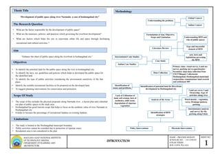
  • 1. SHEET NO. 1 NAME – PRAVEEN MUKATI SCHOLAR. NO. - 141109029 B PLAN THESIS SUB. CODE: PLA 424 INTRODUCTION MAULANA AZAD NATIONAL INSTITUTE OF TECHNOLOGY, BHOPAL DEPARTMENT OF PLANNING AND ARCHIETECTURE Scope Of Study Aim “Enhance the share of public space along the riverfront in hoshangabad city.” Objectives • To identify the potential land for the public space along the river in hoshangabad city. • To identify the laws, act, guidelines and policies which helps to developed the public space for the identified land. • To identify the type of public activities considering the environment sensitivity of the that place. • Identify the suitable recreational facilities to be proposed on the developed land. • To suggest planning interventions for conservation and protection. The Research Question • The scope of this includes the physical proposals along Narmada river , a layout plan and a detailed out plan of public spaces in the study area. • Hoshangabad has good tourism scope that helps to focus on the aesthetic value of river Narmada in Hoshangabad city • It helps to increase the percentage of recreational landuse on existing landuse. Limitations • The study is limited to the Hoshangabad municipal boundary. • Public activities cannot be extended due to protection of riparian zones. • Residential area is not considered in the plan “Development of public space along river Narmada- a case of hoshangabad city” Thesis Title Methodology Understanding the problem Global Context Indian Context Formulation of Aim, Objective, Scope and Limitation Literature Review Understanding RFD and role of public spaces Type and Successful element of RFD acts, laws and legislations governing the RFD Case Study Indian Case Studies International Cade Studies Data Collection Analysis of the Areas Identification of potential land for Riverfront development in Hoshangabad city Questionnaire analysis and survey for the parking along Ghats Land use cover, Land Ownership ,Type of activities along river Ward density , vegetation cover, Drainage pattern, parking Identification of RFD strategies Policy Interventions Physicals Intervention Primary data- visual survey, Land use survey, parking survey,questionaire Secondary data-data collection from TNCP Bhopal, Collectorate Hoshangabad, Hoshangabad municipal corporation, commissioner land records and settlement MP Identification of issues and problems Lack of Utilization of land, soil erosion, lack of aesthetics, solid waste, degradation of riparian vegetation • What are the factor responsible for the development of public space? • What are the measures, policies, and practices which governing the riverfront development? • What are factors which helps the city to rejuvenate urban life and space through facilitating recreational and cultural activities ?
  • 2. “In general, a riverfront is the zone of interaction between urban development’s and the water and a riverfront area is considered as a unique and irreplaceable resource where it is the interface between land, water, air, sun and productive plants. Moreover, the riverfront is characterized as a place integrating land with water and having a natural attraction to people Definition Riverfront Public space Examples include spaces such as plazas, town squares, parks, marketplaces, public commons and malls, public greens, piers, special areas within convention centers or grounds, sites within public buildings, lobbies, concourses, or public spaces within private buildings. Definition of riverfront by different scholars Redevelopment of industrial riverfronts with public-private partnership models can be a way to utilize existing urban riverfronts, and transform them into an inclusive public space Types of riverfront guo (1998) as cited in dong (2004, p. 7)-A more detailed definition by guo (1998) as cited in dong (2004, p. 7) described the riverfront as the interface point where land and water meet, between approximately 200 to 300 meters from the water line and 1 to 2 km to the land site and also takes in land within 20 minutes walking distance. wu & gao, 2002, as cited in dong (2004, p. 7- It is an integrated system consisting of multiple features, of which the water forms the center, and enclosed by substantial objects , added the riverfront area should have multiple features which incorporate each other and surrounded by structural and nonstructural objects to form a focal point Breen & rigby as cited (1996, p.5 ) assign developed riverfronts into six distinct groups: commercial riverfronts; cultural, educational and environmental riverfronts; historic riverfronts; recreational riverfronts; residential riverfronts; and working riverfronts Goodwin (1999) argues that waterfront boundaries are difficult to determine and in some instance planning efforts might focus on a small part of a larger indistinct waterfront area. He presents that “The concept of a waterfront district helps to identify distinct nodes of revitalization activity within long urban shoreline reaches” Dong (2004) cites vellaga (2001) to discuss how cities now have turned to an array of regulatory tools (zoning, design guidelines and development agreements) to overcome financial hurdles to acquire new lands for public amenities. A public space may be a gathering spot or part of a neighborhood, downtown, special district, waterfront, or other area within the public realm that helps promote social interaction and a sense of community. • The Natural Waterfront, comprising beaches, wetlands, wildlife habitats, sensitive ecosystems and the water itself. • The Public Waterfront, including parks, esplanades, piers, street ends, vistas and waterways that offer public open spaces and waterfront views. • The Working Waterfront, where water dependent, maritime and industrial uses cluster or where various transportation and municipal facilities are dispersed. • The Redeveloping Waterfront, where land uses have recently changed or where vacant and underutilized properties suggest potential for beneficial change. Trend of riverfront development 1960s - massive riverfront development began and consequently initiated the world-wide era of riverfront revitalization. 1970s - urban riverfront redevelopment bloomed, 1980s - accelerated and continued in the future. SHEET NO. 2 NAME – PRAVEEN MUKATI SCHOLAR. NO. - 141109029 B PLAN THESIS SUB. CODE: PLA 424 LITERATURE REVIEW MAULANA AZAD NATIONAL INSTITUTE OF TECHNOLOGY, BHOPAL DEPARTMENT OF PLANNING AND ARCHIETECTURE Elements of successful riverfront development elements of successful river front development effective managem ent begining the project financial faesibility environm ental approval constructi on technolog y authencit y function project theme and image public perceptio n of need
  • 3. A public space may be a gathering spot or part of a neighborhood, downtown, special district, waterfront, or other area within the public realm that helps promote social interaction and a sense of community Importance of Public space in riverfront • coordinate the water usage and supporting land base to maximize the economic, recreational and environmental asset of water bodies Characteristics of public spaces • Dynamic area- Riverfront zone is a dynamic area with frequently changing biological, chemical and general attributes Special characteristics of riverfront • Habitat- Riverfront zone include highly productive and biologically diverse ecosystems that offer crucial nursery for many species • Natural defence-Riverfront zone features such as mangrove forests serves a critical natural defense against natural hazards • Pollution moderator- Water ecosystem may act to reduce impacts of pollutions originating from land such as wetland absorbing excess nutrients , sediments, human waste. • Establish a water’s edge that is continuous, publicly accessible and magnificent. • create a network of public spaces that attract and invite both localities and tourists to riverfront. • require design excellence for riverfront public spaces. Provide a wide-range of public spaces that foster culture and creativity in our city. • ensure all public spaces adhere to a high environmental standard. • strengthen connections along the riverfront on both sides of the river • improve the aquatic habitat and water quality along the riverfront and integrate them with river and stream improvements. • maintain a consistency in riverfront design elements in all public spaces (i.e. Park benches and lamp posts). Various Act, laws, policy and guidelines governs riverfront development Environmental protection act 1986 The Constitution of India also provides for the protection of the environment. Article 48A of the Constitution specifies that the State shall endeavor to protect and improve the environment and to safeguard the forests and wildlife of the country. Article 51 A further provides that every citizen shall protect the environment. • develop strong link between existing communities and emerging riverfront communities and spaces SHEET NO. 3 NAME – PRAVEEN MUKATI SCHOLAR. NO. - 141109029 B PLAN THESIS SUB. CODE: PLA 424 LITERATURE REVIEW AND ACT, GUIDELINES AND POLICIES MAULANA AZAD NATIONAL INSTITUTE OF TECHNOLOGY, BHOPAL DEPARTMENT OF PLANNING AND ARCHIETECTURE Guidelines for the Preparation of Urban River Management Plan for all Class II Towns in Ganga/Narmada River Basin 2010 1. Removal of encroachments and land acquisition for riverbank beautification and related development works. 2. Restriction/banning of certain activities on the riverbank or in the river, viz., open defecation, disposal of solid waste, washing of clothes, wallowing of cattle, throwing of floral offerings, disposal of corpses, routine bathing (as opposed to ritual bathing), etc. 3. Development/restoration of the riverbank area, i.e., construction / restoration of ghats, provision of public baths and toilets, construction of walkways, parks, other public spaces, access roads, commercial establishments, etc. Riverfront guidelines by MoEF Type a – area development plans (adp) would apply to sub-projects where larger river front Stretches say 1-2 km long and 30-40 m wide are involved. Facades of rfd works must be match with the cultural, religious and heritage value of the place. Given the meandering characteristic of most rivers, one of the essential requirements should be the availability of water along the bank round the year.
  • 4. SHEET NO. 4 NAME – PRAVEEN MUKATI SCHOLAR. NO. - 141109029 B PLAN THESIS SUB. CODE: PLA 424 ACT, GUIDELINES AND POLICIES MAULANA AZAD NATIONAL INSTITUTE OF TECHNOLOGY, BHOPAL DEPARTMENT OF PLANNING AND ARCHIETECTURE Guidelines for the Preparation of Urban River Management Plan for all Class II Towns in Ganga/Narmada River Basin 2010 1. Removal of encroachments and land acquisition for riverbank beautification and related development works. 2. Restriction/banning of certain activities on the riverbank or in the river, viz., open defecation, disposal of solid waste, washing of clothes, wallowing of cattle, throwing of floral offerings, disposal of corpses, routine bathing (as opposed to ritual bathing), etc. 3. Development/restoration of the riverbank area, i.e., construction / restoration of ghats, provision of public baths and toilets, construction of walkways, parks, other public spaces, access roads, commercial establishments, etc. . A Guide to Riverfront Development Connecting communities to the water SMARTNET.NIUA-Riverbanks, shorelines, riparian buffers, and river habitat are critically important when planning any riverfront project.  The riparian buffer should be no less than 10-20 metre at its narrowest, with three zones of buffer from the stream edge inland.  Provide a minimum walkway width of 10-15 feet for perpendicular connections  Connections should be accessible to the public even when they are adjacent to private development.  Riverfront trails should be simple and integrated with the landscape and defined by the vegetation of the park  Promenades should be 15-20 feet and along with 3-5 feet tree range , a riverfront park should be considered part of the park.  Retaining wall must be.5-1metre of width along with promenade of 5-10metre  Perpendicular Connections- Provide a minimum walkway width of 12 feet for perpendicular connections to be maintained as an easement or public right-of-way. Provide a minimum setback for all structures, including fences, of 10 feet on either side of the connection. Water(prevention and control of pollution)1974 The act aims to prevent and control water pollution and to maintain/restore wholesomeness of water by establishing central and state pollution control board to monitor and enforce the regulations. Biological Diversity Act, 2002 . Article 48A of the directive principles of state policy declares: “the State shall endeavor to protect and improve the environment and to safeguard the forests and wild life of the country”. ‘Fundamental Duties’ as envisaged in Article 51A (g), imposes a similar responsibility on every citizen ‘to protect and improve the natural environment including forests, lakes, rivers and wild life and to have compassion for living creatures. National green tribunal act 2010 Order of the National Green Tribunal (Central Zonal Bench, Bhopal) in the matter of Paryavaran Avam Manav Sanrakshan Samiti Vs. State of Madhya Pradesh & Others dated 09/04/2015 regarding construction near Narmada River with respect to No Construction Zone and the 30 meter Zone. National Green Tribunal on Friday lifted the ban on sand mining in the rivers in Madhya Pradesh. Narmada valley development authority of MP • -to shoulder responsibility of human resettlement and rehabilitation in respect of projects in the Narmada Valley, to establish towns and villages and -to take all necessary measures to ensure planned settlement and rehabilitation; • -to advise for the proper conservation and development of forests, wildlife and fisheries in the Narmada Valley; • -to acquire and manage land in the Narmada Valley for the purpose of carrying out engineering works, to provide for human. • -no construction has to be done 10-15 from the edges of narmada river Riverfront guidelines by MoEF Type a – area development plans (adp) would apply to sub- projects where larger river front Stretches say 1-2 km long and 30-40 m wide are involved. Facades of rfd works must be match with the cultural, religious and heritage value of the place. Given the meandering characteristic of most rivers, one of the essential requirements should be the availability of water along the bank round the year. Madhya Pradesh Special Project & Township (Development, Regulation & Control) Rules, 2011 Construction on river 10-20m from Rivers or lakes/ponds/reservoirs or nalas/canal or flood affected areas
  • 5. Case studies-Review Case study 1- Malaysia riverfront development Waterfront Areas : Kuching Riverfront. Malacca Waterfront, Glenmarie Riverfront The current pattern of riverfront development in malaysia now focuses more on mixed-use development and recreation, while incorporating Malaysian cultural and historical values. Case study areas Kuching riverfront Malacca riverfront Glenmarie riverfront Name of water body Sarawak river Malacca river Langat river Type of project Recreational Recreational Recreational Project’s owner Project’s owner State of malacca Drb-hicom Amenities Restaurants, shops, river access, river settlement River access, shops ,riverfront settlements Restaurants , river access, housing Views River views & city River views & city Limited river views Proximity to river 50m 50m 50m Proximity to CBD 1km 1km 35km The main objective of this development proposal is to strengthen the commercial and recreational activities which reflects character, social, culture and identity of the place. Characteristic of Malaysian riverfront development Location of Malaysian riverfront development SHEET NO. 5 NAME – PRAVEEN MUKATI SCHOLAR. NO. - 141109029 B PLAN THESIS SUB. CODE: PLA 424 LITERATURE REVIEW- CASE STUDY OF MALAYSIA AND SABARMATI RIVERFRONT DEVELOPMENT MAULANA AZAD NATIONAL INSTITUTE OF TECHNOLOGY, BHOPAL DEPARTMENT OF PLANNING AND ARCHIETECTURE • Make the riverfront accessible to the public • Stop the flow of sewage, keep the river clean and pollution-free • Reduce risk of erosion and flooding in flood prone neighborhoods • Create riverfront parks, promenades and Ghats to enjoy the water. • Revitalize riverfront neighborhoods, rejuvenate Ahmedabad. • Generate resources to pay for all of the foregoing. • Stitch together east and west Ahmedabad. • Create a memorable identity for Ahmedabad. Location of Sabarmati riverfront development This project aims to transform Ahmedabad's historic yet neglected river into a vibrant & vital focus for the Ahmedabad city. The development project encompasses both banks of the Sabarmati for a 10.5 kms, stretch, creating approximately 185 hectares of reclaimed land Case study 2 Sabarmati riverfront development Objectives of Sabarmati riverfront development The Sabarmati Riverfront Project add almost 10,00,000 sq. mts. of parks, promenades and plazas to Ahmedabad.  The Sabarmati Riverfront Project help provide Ahmedabad with many new cultural trade and social institutions (36,000 Sq.m).  Creating of City Level Recreational Activities – Water Sports and Floating restaurants.  Tourist attraction.  Recharge of Ground water Aquifers of the city  Continuous Green coverage along the river corridor.  Elimination of Flood Hazard. • Creating Vibrant Urban neighborhoods and beautification of the city
  • 6. Case study areas Sabarmati riverfront Name of water body Sabarmati river Type of project Recreational Company Sabarmati river front development corporation limited (srfdcl) Amenities Restaurants, river access, shops, riverfront settlements, gardens, walkways, amusement parks, golf course, water sports Views River views & city Proximity to river 50m Proximity to cbd 1 km Financial sources The project has been planned as a self-financing project. The revenues would be Generated from the sale of proclaimed land. Construction period Start on early 2005 & complete on nov 2012 Development area Includes both banks of the sabarmati for a 10.5 kms, stretch, creating approximately 185 hectares of reclaimed land Developer Ahmedabad municipal corporation setup special purpose vehicle - sabarmati riverFront development corporation limited Consultants Hcp design, planning and management pvt. Ltd Concept It is an environmental improvement, social and urban rejuvenation project by Development of riverfront along Sabarmati river in the commercial capital of state. The objective of the project is to improve spatial structure and habitat conditions of The river and adjoining areas. Basically it is an urban renewal project Inferences from malaysia and Sabarmati riverfront development Characteristics of Sabarmati riverfront development Malaysia riverfront development 1) to help the local vendors in terms of wet market & dry market 2) commercial oriented development 3) recreational development like walkways & yoga mediation center 4) River beautification works Sabarmati riverfront development 1) urban reform project 2) flood mitigation works 3) recreational development 4) public space creation 5) slum rehabilitation works 6) groundwater recharge 7) infrastructure development SHEET NO. 6 NAME – PRAVEEN MUKATI SCHOLAR. NO. - 141109029 B PLAN THESIS SUB. CODE: PLA 424 MAULANA AZAD NATIONAL INSTITUTE OF TECHNOLOGY, BHOPAL DEPARTMENT OF PLANNING AND ARCHIETECTURE LITERATURE REVIEW- CASE STUDY OF MALAYSIA AND SABARMATI RIVERFRONT DEVELOPMENT qualities are listed out in the riverfront destinations. Identity & image Flexibilit y in design Diverse funding sources Landuse managem ent Amenitie s Access and linkage Edge uses Attractio ns & destinatio ns Qualities obtained from malaysia and Sabarmati riverfront development
  • 7. Demographic profile of Hoshangabad city Introduction: Hoshangabad city • Hoshangabad is about 80 km from Bhopal and is well connected by both- road and railways. Itarsi, a major railway junction, that connects major towns across the country, is about 18 kms from Hoshangabad. • The Narmada, the largest river flowing through the city, gives the identity of holy city. • Latitude:N22o 46 Longitude: E77o 44 • The town is surrounded by Khojanpur village in the north, Neemsadia on the south, Rajpur on the east and Deshmehani on the west. YEARS TOTAL POPULATION TOTAL HH HH SIZE MALE FEMALE CHILD POP 1991 70914 18521 4.91 36364 34550 9954 2001 97424 21578 5.14 50710 46714 11249 2011 117988 24737 5.98 61716 56272 13281 70914 97424 117988 36364 50710 61716 34550 46714 56272 1991 2001 2011 Population of Hoshangabad city TOTAL POPULATION MALE FEMALE • Population of Hoshangabad gradually increased between 1991-2011 • Household size also increased between 1991-2011 Existing demographic profile Location of -Study area Hoshangabad SHEET NO. 7 NAME – PRAVEEN MUKATI SCHOLAR. NO. - 141109029 B PLAN THESIS SUB. CODE: PLA 424 DATA COLLECTION DEMOGRAPHIC PROFILE HOSHANGABAD CITY MAULANA AZAD NATIONAL INSTITUTE OF TECHNOLOGY, BHOPAL DEPARTMENT OF PLANNING AND ARCHIETECTURE Hoshangabad is a class-ii town of Madhya pradesh Hoshangabad municipality spreads over an extent about 24.27 sq.km and is divided into 33 wards The population of the town was 117988 as per census 2011. Hoshangabad nagarapalika parishad has constituted in the year 1867 Hoshangabad is a holy city with roughly about 0.10 to 0.15 million pilgrims visit during the festive seasons. Such occasions are reported to be almost once every month. Hoshangabad is district and tehsil headquarter and important agriculture trade centre in the region Hoshangabad municipality has total administration over 24,737 houses to which it supplies basic amenities like water and sewerage. It is also authorize to build roads within municipality limits and impose taxes on properties coming under its jurisdiction. It comprising of the nine revenue villages khojanpur, rasuliya, jalalabad, malakhedi, kishanpura, dongri, budhwada, kulamadi and phefarta as shown below in figure 2. Kishanpura is the only village which is totally inside the municipal area; whereas the other villages have some part inside the municipal limits
  • 8. Hoshangabad ward wise population year No. of households 1991 18521 2001 21578 2011 24737 Between 1991-2011 Households and population of Hoshangabad increased due to : • Good tourism in city. • Extension of municipality area of development because of good agriculture marketing. • Literacy rate gradually increased over the decades, In 2011 it was 87.21% YEARS TOTAL POPULATION LIT POP LITERACY RATE 1991 70914 50547 71.27 2001 97424 72487 74.40 2011 117988 103108 87.21 YEARS TOTAL POPULATI ON SC POP ST POP TOTAL WORK FORCE NON WORK FORCE 1991 70914 10586 2425 60524 10390 2001 97424 16255 4421 58765 38659 2011 117988 20350 6938 70942 47046 • Settlement have lower no. of SC and ST population And high no. of non working force. • Mainly working population is involved in: • Tourism (Pilgrimage and temple shops) • Labour (construction in MNREGA) • Agriculture 14 Ward no - 14 2,886 83.1% 880 15 Ward no - 15 5,446 76.4% 841 16 Ward no - 16 6,684 76% 899 17 Ward no - 17 4,048 82.6% 1,031 18 Ward no - 18 9,009 79.3% 868 19 Ward no - 19 8,131 81.3% 932 20 Ward no - 20 4,402 59.5% 903 21 Ward no - 21 4,794 76.4% 901 22 Ward no - 22 2,011 86.4% 930 23 Ward no - 23 2,532 84% 910 24 Ward no - 24 2,486 73.1% 923 25 Ward no - 25 9,241 83.1% 926 26 Ward no - 26 4,404 65.1% 900 27 Ward no - 27 2,398 75.7% 909 28 Ward no - 28 1,917 78.9% 904 29 Ward no - 29 3,524 76.8% 884 30 Ward no - 30 2,656 79.6% 819 31 Ward no - 31 3,275 74.9% 902 32 Ward no - 32 4,765 71.1% 939 33 Ward no - 33 4,488 65.8% 933 SHEET NO. 8 NAME – PRAVEEN MUKATI SCHOLAR. NO. - 141109029 B PLAN THESIS SUB. CODE: PLA 424 MAULANA AZAD NATIONAL INSTITUTE OF TECHNOLOGY, BHOPAL DEPARTMENT OF PLANNING AND ARCHIETECTURE S no. Ward Population Literacy Sex ratio 1 Ward no - 1 3,084 69.7% 898 2 Ward no - 2 2,054 85.5% 921 3 Ward no - 3 2,048 87.2% 889 4 Ward no - 4 1,969 78.8% 915 5 Ward no - 5 1,535 84.8% 973 6 Ward no - 6 2,356 71.3% 880 7 Ward no - 7 2,230 74.3% 909 8 Ward no - 8 1,767 79.6% 948 9 Ward no - 9 1,907 76.4% 960 10 Ward no - 10 1,355 85.3% 919 11 Ward no - 11 1,695 84.3% 915 12 Ward no - 12 2,343 81.6% 1,048 13 Ward no - 13 4,548 80.8% 934 Ward delineation map DATA COLLECTION DEMOGRAPHIC PROFILE HOSHANGABAD CITY
  • 9. SHEET NO. 9 NAME – PRAVEEN MUKATI SCHOLAR. NO. - 141109029 B PLAN THESIS SUB. CODE: PLA 424 DATA COLLECTION- ANALYSIS OF LANDUSE,TRANSPORTATION AND DRAINAGE OF HOSHANGABAD MAULANA AZAD NATIONAL INSTITUTE OF TECHNOLOGY, BHOPAL DEPARTMENT OF PLANNING AND ARCHIETECTURE Hoshangabad Existing Landuse 58% 4%2%5% 1% 1% 9% 20% Residential Commercial Industrial Institutional Public amenities Recreational Circulation Ground & parks Nagarpalika parishad limits Nagarpalika parishad limits S.No Land use category Area in (ha) % to total extent of town Extended area Total planning area % total planning area 1 Residential 1248.98 56.76 56.14 1356 58 2 Commercial 24.41 1.11 - 24.41 3.7 3 Industrial 9.74 0.44 - 9.74 1.5 4 Institutional 87.45 3.98 - 87.45 5.49 5 Public amenities 8.1 0.37 - 8.1 1.25 6 Recreational 6.55 0.3 - 6.55 1.01 7 Circulation 59.08 2.69 - 59.08 9.11 8 Vacant land 268.56 12.21 - - - 9 Agricultural land 406.75 18.49 - - 20 10 Water bodies 80.38 3.65 - - - Total 2200 100 56.14 648.22 100 Hoshangabad Existing Transportation map and drainage pattern of city The land use under the transportation is 59.08 ha, which is 9.11% of the total existing land-use . There are four major natural drains – Kori Ghat nallah, Ladiya nallah, Sukh Tawa nallah and Khojanpur nallah (Sukh Tawa Nallah discharges into Khojanpur nallah) that carry the wastewater for ultimate disposal into River Narmada Hoshangabad drainage pattern of city Ladiya nallah Sukh Tawa nallah Khojanpur nallah Kori Ghat nallah
  • 10. SHEET NO. 10 NAME – PRAVEEN MUKATI SCHOLAR. NO. - 141109029 B PLAN THESIS SUB. CODE: PLA 424 DATA ANALYSIS AND SYNTHESIS OF IDENTIFIED LAND MAULANA AZAD NATIONAL INSTITUTE OF TECHNOLOGY, BHOPAL DEPARTMENT OF PLANNING AND ARCHIETECTURE Introduction to the identified land-Hoshangabad The stretch for riverfront development has been selected on the basis of potential government land and area delineated on the basis of ward boundary in which stretch cover 2.78 km of stretch, according to national river conservation plan & riverfront edge design guidelines ,water prevention and riverfront guidelines says that no construction 10-15metre from the river because of riparian vegetation after that 5 metre buffer for the promenade, 15metre buffer has to be allocated for the riverfront development .according to Madhya pradesh National green tribunal river no construction activities has been allowed 15metre from the river. River stretch boundary has to be decided on the basis of the ward boundary. Total area of the stretch covers 9.09hecatre of land. Base map of identified land Ward delineation map There are 5 wards in the riverfront area. Stretch which covers the ward no 1,2,3,26 and 27 in which the population of the five wards is 13988 it consist of 8.4% of total city population. 22% 15% 15% 31% 17% ward wise % of population ward no1 ward no 2 ward no 3 ward no26 ward no 27 Ward density map .The wards 1, 2, 3, 26 and 27 have least density in the range 400-800 pph and are shown in the green color. Rest of the wards have high density and are shown in the dark green color.wards contains least density because of this Land ownership map Land ownership –ward no. 1, 2, 3, 26 and 27 , which mainly consist of more potential govt. land as comparatively the other ward, and have least density which shows the scope of development of physical interventions on the identified land as comparatively other part of Hoshangabad city 1:29100 1:29100 1:29100 1:29100
  • 11. SHEET NO. 11 NAME – PRAVEEN MUKATI SCHOLAR. NO. - 141109029 B PLAN THESIS SUB. CODE: PLA 424 MAULANA AZAD NATIONAL INSTITUTE OF TECHNOLOGY, BHOPAL DEPARTMENT OF PLANNING AND ARCHIETECTURE Landuse analysis of identified land 37% 28% 33% 2% Land Use Composition Residential Recreation al PSP Roads Existing Landuse map • Existing land use pattern of the stretch which mainly consist of semi public spaces, residential and recreational landuse. The following landuse mainly consist of potential govt. Land on the basis of ownership map. • Stretch which covers the ward no 1,2,3,26 and 27 in which the population of the five wards is 13988 it consist of 8.4% of total city population. Existing condition of area Stretch which covers the ward no 1,2,3,26 and 27 in which problem faced by the identified land are as follows- • Direct disposal of sewage into the Narmada river • There is no proper utilization of riparian zones and potential land. • Condition of solid waste management is very poor and unhygienic. • There is no parking facility for the visitors which causes congestion during occasional fair like amawasiya and Purnima. • There was no any formal market has been provided for the vendors and hawkers. • Lack of public facilities and services like no community toilets, changing room and safety like CCTV and divers. • Ladiya nallah which flows through the identified land which mainly occurs durin the monsoon times .there is no such sewage discharge in identified area Existing built up map Ladiya nala The existing built map consist of 33% and rest 67% of land is still not developed Which has the scope of development. Non Built map consist of different landuse in green cover and open land are present. Some of the land came under green cover which can not be developed because of good vegetation. 1:29100 1:29100 1:29100 DATA ANALYSIS AND SYNTHESIS OF IDENTIFIED LAND
  • 12. SHEET NO. 12 NAME – PRAVEEN MUKATI SCHOLAR. NO. - 141109029 B PLAN THESIS SUB. CODE: PLA 424 QUESTIONAIRE ANALYSIS AND PEAK ACCUMULATION SURVEY ANALYSIS SYNTHESIS MAULANA AZAD NATIONAL INSTITUTE OF TECHNOLOGY, BHOPAL DEPARTMENT OF PLANNING AND ARCHIETECTURE Questionnaire and peak accumulation survey analysis 13% 25% 34% 28% Age Group Composition <15 15_25 25_40 40+ 72% 28% Gender Male Female • Mostly males are visited on the riverfront area of Narmada , which contains activities like ,religious shopping, swimming and for education purpose, visitors are more as comparatively the people visited for workplace. While the females were mostly visited at the river front area for the shopping because Itwara bazaar located near the river Narmada.6 10% 25% 34% 26% 3% 2% Purpose of Visit Recreational Religious Workplace Shopping Education Swimming • Purpose of the peoples visited on the riverfront area mostly age group of 40+visited on Narmada river for religious purpose in which there is absence of which formal shops .there is more scope of small commercial hub at the riverfront area. • There was good scope of formal market located on the area. • Riverfront has the potential of visitors holding but there was no any such place for visitors resident. • Mostly peoples visited at that area for jogging, walking and for mental relaxation at the morning and evening, there is lack of services and facilities 30% 26% 22% 20% Problems/ Issues Congestion Hygiene Lack of Public Services Safety •There is lack of public services on the ghat of Narmada river. There is a scope of public services on the riverfront area for the visitors. •Rest of the problem related to safety which can be solved easily by providing safety related facilities. 20% 20% 15% 10% 22% 13% Improvements Solid waste Management Aesthetics Lighting Security Parking Public Facilities Encroachmen t 16% 17% 13% 12% 15% 15% 12% Facilities Open gym Meditation and Yoga Center Boat club Food court Aashram/ dharamshala Garden and Park Light Show •Most of the people want facilities like meditation and yoga centre, food court on the riverfront area ,people those who visited river for the religious purpose mostly prefer facilities like mediation yoga centre ,ashram/dharmsala (parikrama vaasi ). •People those who visited Narmada river for the recreation activities like walking and jogging for refreshment ,mostly prefer open gym at the ghat and also want parks and gardens. • Most of the peoples from age group of 40+ because people belong to this category mainly involve with religious activity and has good scope of tourism. • Peoples have less opportunity of commercial activities on occasion of religious fair mostly on poornima and amawasiya . • Mostly peoples visited on the Itwara bazar for shopping. •people faces problem of parking at the riverfront area because of this more congestion occur during the religious fair .there is scope of parking facilities on the riverfront area. •problem related to solid waste management on the river front area there is non availability of services related to waste management on the Sethani Ghats and on along the river edges because waste during fair are thrown along the river. Solid waste management has to be done the riverfront area only along the river edges. •people want aesthetic and public facilities on the riverfront area. because there is lack of public facilities and also want services related to safety •People also wants garden and parks along the riverfront area. there is scope of gardens and parks on the riverfront area. peak accumulation survey analysis at Sethani ghat SETHANI GHAT Parking Slot 0 20 40 60 80 100 120 09:00:00 09:30:00 10:00:00 10:30:00 11:00:00 11:30:00 12:00:00 00:00:00 13:00:00 13:30:00 14:00:00 14:30:00 15:00:00 15:30:00 16:00:00 16:30:00 17:00:00 17:30:00 vehicles CAR TWO WHEELER AUTO/ TEMPO Problems • Encroachment due to illegal parking outside the shops • Parking in the middle of the road in zone 1. i.e., in Narmada Ghat. • Very few park their vehicles in the paid parking area. • On street parking between two streams. 1:29100
  • 13. SHEET NO. 13 NAME – PRAVEEN MUKATI SCHOLAR. NO. - 141109029 B PLAN THESIS SUB. CODE: PLA 424 PERSPECTIVE AND BENEFIT OF PROPOSAL PROPOSAL FOR RETAINING WALLAND PROMENADE MAULANA AZAD NATIONAL INSTITUTE OF TECHNOLOGY, BHOPAL DEPARTMENT OF PLANNING AND ARCHIETECTURE Perspective behind the proposal plan Study area Government land Land for development of social purpose Recreation purpose Without fee Recreation purpose With fee Developed land Under developed land Policy for the ghat revitalization Construction of retaining wall parallel to promenade •Boat club •Informal market •On street parking for 2w •Open gym •Meditation and yoga center •Ashram/dharmsala •Garden & water front park •Light show •Lower promenade •Riverfront walkway •Open air theatre Proposals Benefits A Retaining wall  To protect the natural waterfront  In streamlining the water course  It will helpful in erosion control  Helpful in solid waste management  To prevent the riverfront becoming a dumping site. B Waterfront park & lower promenade  Waterfront Park & footpath: these two elements are running parallel to the river, offers a unique vista to the people towards water body. Along the river people can walk and do fishing. This segment along the river will be as active as a public street.  Along the river footpath will provide direct access to water for boating and fishing.  It can be the place for social integration C Boat club zone It will be a children attraction zone, profit/revenue earning, , it will be active recreational area D formal market It is a local bazaar for vegetable or fruits sops or vendors.it consist of handicrafts. E Light show/Open air theatre It is proposed along the riverfront for increasing the aesthetic value and for entertainment purpose of visitors along narmada river. F Open gym For Gym, equipments available free of cost for the children to old age people G Ashram/Dharamshala To organized cultural activities & for the parikrma vaasi and for the people visited on fair H Yoga and meditation centre To organize the activities like yoga and for the relief of mind medication centre has been provided for the peoples those who visited for walk at morning and evening time. I Parking space There will be parking area for two wheeler vehicles near the Narmada river ghat and along the informal market and parks &garden. Recreational activities Proposal and their benefits Proposal for Retaining wall and promenade According to MoEF policies and guidelines stretch for the riverfront development must not be less than 2km, and 10-15 meter area should be no construction zone because of the presence of riparian vegetation. The lower promenade must not be less than 15-20feet with the presence of lights, trees and plantation has been along the lower promenade. Existing riparian vegetation space Narmada river 10M no construction zone 5M lower promenade .5M width Retaining wall 30M Proposals Water level 15-20 M According to riverfront guidelines • Retaining wall area along river– 2.78 km • Retaining wall width- .5metre • Sethani ghat - .5 km • Lower promenade area along river-2.28km • Lower promenade width -5meter (15feet) Retaining wall Lower promenade
  • 14. SHEET NO. 14 NAME – PRAVEEN MUKATI SCHOLAR. NO. - 141109029 B PLAN THESIS SUB. CODE: PLA 424 PROPOSAL PLAN FOR RECREATIONALACTIVITIES MAULANA AZAD NATIONAL INSTITUTE OF TECHNOLOGY, BHOPAL DEPARTMENT OF PLANNING AND ARCHIETECTURE Proposed area classification for recreational activities Area in metre square Riverfront park 5104 Boat club 253 Open gym 4493 Mediation and yoga centre 974 Light show along ghat 390 Ashram/ dharmshala 1156 Informal markets 900 Parking facility 485 Open air theatre 2623 Total area 16378 Proposed stretch for retaining wall Area in km retaining wall 2.78 km Proposed area for lower promenade Area in metre square Lower promenade 2.28km 16761 Proposal for recreational activities Proposal for recreational activities based on the imposition of three Maps in which density map, land ownership map and built up map Plays an important role. Imposition three layers identify the most Suitable land for the development of recreational activities on the Identified area. Proposal has to be given on the basis of considering the environmental sensitivity of that place. Proposal consist of both the recreational activities with fee and without fee which helps for the purpose of social development, Density map Land ownership map Built up map
  • 15. SHEET NO. 15 NAME – PRAVEEN MUKATI SCHOLAR. NO. - 141109029 B PLAN THESIS SUB. CODE: PLA 424 PROPOSAL PLAN FOR RIVERFRONT WALK MAULANA AZAD NATIONAL INSTITUTE OF TECHNOLOGY, BHOPAL DEPARTMENT OF PLANNING AND ARCHIETECTURE Riverfront walkway- The riverfront walkway focuses on developing a riverfront walk connecting the people with different recreational activities and provide accessibility to the formal market, and along with Restoration and Infra development. The primary focus would be to create enabling infrastructure interconnecting major recreational activities along the river Narmada. Proposed Component  Strengthening of approach Roads leading to Pilgrimage Assets along the river  Beautification of Approach Roads leading to Pilgrimage Assets along the riverfront Walk.  Facade restoration of temples along the walk.  Directional Signage  Covering of open drains.  Street lighting inspired by local architecture.  Seating benches.  Beautification of walkway Proposal for riverfront walk • The guidelines recommended widths of footpaths as per their carrying capacity in terms of number of persons per hour. The minimum width of a footpath in the guidelines is suggested to be 1.5 meters, at places where number of people going in both directions per hour is less than 800. A footpath of width 4 meters can carry 6,000 persons per hour per in one direction or 4,000 persons in both the directions • The guidelines illustrated various design elements leading to universal access. It also recommended various lane sizes for Non- Motorized Transport (NMT) lanes for bicyclists, cycle rickshaws, hand push carts, hawker carts, animal carts etc. It recommended the minimum acceptable width of NMT lane for single lane movement to be 2.5 metres (p.76) • The minimum width of a footpath was recommended to be 1.8 metres which allows minimum two people to cross each other comfortably. The footpath should have clear headroom of minimum 2.4 metres (pp.43-44). Width of footpaths was also recommended according to land-uses as pedestrian flow is largely determined by it. Indian road congress -guidelines for riverfront walk