SlideShare una empresa de Scribd logo
1 de 22
Geographic Grid- Latitudes and
Longitudes
The Geographic Grid
• The network of parallels of
latitudes and meridians of longitudes
drawn on a map or a globe is called
the Geographic Grid.
• The intersection of latitude and
longitude at right angle points out the
exact position of a place on the
Earth’s surface.
• There are two reference lines called the equator and the prime
meridian, both of which are imaginary lines adopted uniformly by
all the countries to avoid confusion.
Latitudes
A latitude is an angular
distance of a place north or
south of the equator.
The equator is the imaginary
great Circle also known
as the 0⁰ latitude.
It divides earth into northern and southern hemisphere.
• Places north of the equator lies in the northern hemisphere and
are represented as (⁰N).
• Places south of the equator lies in the southern hemisphere and
are represented as (⁰S).
Parallels of Latitudes
Latitude
North Pole
South Pole
Lines of
latitude are
numbered
from 0° at the
equator to
90° N.L. at the
North Pole.
Lines of
latitude are
numbered
from 0° at
the equator
to 90° S.L. at
the South
Pole.
]
[
90 80
70
60
50
40
20
30
10
90
80
70
60
50
40
20
10
30
Latitude
The North Pole
is at 90° N
The South Pole
is at 90° S
The equator is
at 0° latitude.
It is neither
north nor
south. It is at
the center
between
north and
south.
40° N is the 40°
line of latitude
north of the
equator.
40° S is the 40° line
of latitude south
of the equator.
Important Parallels Of Latitude
1. The Equator (0⁰)
2. The Tropic of Cancer (23.5⁰N)
3. The Tropic of Capricorn (23.5⁰S)
4. The Arctic Circle (66.5⁰N)
5. The Antarctic Circle (66.5⁰S)
Meridians Of Longitude
• The lines of longitude
are imaginary lines,
which join all the places
having the same angular
distance east or west of
the prime meridian.
The Greenwich meridian
or the prime meridian is the
reference line for measuring east-
westward distance of the earth.
• Prime meridian is taken as 0⁰
meridean.
Prime Meridian
The Prime Meridian (0°) and the 180° line split the earth
into the Western Hemisphere and Eastern Hemisphere.
Prime Meridian
Western
Hemisphere
Eastern
Hemisphere
Places located east of the Prime Meridian have an east longitude
(E) address. Places located west of the Prime Meridian have a
west longitude (W) address.
Longitude
• Lines of Longitude run vertically.
• They are also called Meridians.
• The Prime Meridian is found in Greenwich,
England.
• The Prime Meridian is 0 degrees Longitude.
• Lines of Longitude locate places East or
West of the Prime Meridian.
• There are 180 degrees of east Longitude,
and 180 degrees of west Longitude.
Longitude
Lines of longitude begin
at the Prime Meridian.
60° W is the
60° line of
longitude west
of the Prime
Meridian.
The Prime Meridian is located at 0°. It is neither
east or west
60° E is the
60° line of
longitude
east of the
Prime
Meridian.
W E
LONGITUDE AND TIME
• The world rotates (spins) 360° in 24 hours.
360° / 24 hours = 15° per hour
• The world has 24 time zones, each l5° apart.
THERE IS A 1 HOUR TIME DIFFERENCE FOR EVERY
15° OF LONGITUDE
• Time zones are broad strips that measure 15 degrees wide.
• Time zones differ from their neighboring time zones by 1 hour.
• The lines of longitudes are used to find the time of any place.
• The earth takes 24 hrs to complete one rotation of 360⁰. This
gives rise to a time difference of [(24*60)/ 360] = 4min for one
degree of longitude.
• Therefore ,
1. A time difference of four min has to be added for each 1⁰ of
longitude towards the east.
2. A time difference of four min has to be subtracted for each 1⁰ of
longitude towards west.
Local time:
the time of a place recognized by the mid-day sun is called the loca’
time. All the places located along a particular longitude (from
north pole to south pole) face the overhead sun at the same
time.
Standard Time:
The local time of the central meridian is taken as the standard
time for the whole country or a large area.
• A large area may be crossed by many meridians of longitude,
it means they may have many local times. It would be very
difficult for people to keep on setting their watches according
to local time of the place.
• To avoid such difficulties and confusion, the local time of a
central meridian is taken as the standard time for the whole
country or a large area.
Indian Standard Time (I.S.T.):
The 82.5⁰ E longitude is selected as the central meridian of India
which passes through Prayagraj and is known as the standard
meridian of India.
Greenwich Mean Time:
• The local time of the Greenwich meridian also known as the
prime meridian is considered as the standard time for the
whole world is called the Greenwich Mean Time or G.M.T.
• All the countries for international travel follow it.
Time zones:
• Some countries like Russia, Canada, and USA have large
longitudinal extension where if a single time is followed as
standard time, it will create lot of problems.
• So to avoid such confusion, the countries having large east-
west extension have to follow more than one time zones. For
example , Canada and USA have 6 time zones.
Time Zones Of The World
International date line
• The international date-line, fixed
by international agreement, is an
imaginary line along the 180⁰ meridian
extending from north pole to south
Pole.
• International date line roughly
follows 180⁰ longitude and is not a
straight line.
-because few countries and islands are
located very close to 180⁰ longitude. To
keep them wholly on the same side ,
the international dateline goes zigzag
way, passing over seas and oceans only.
The Great Circle
• If the earth is divided exactly
into two halves by a circle with that
of the earth’s centre, simultaneo-
-usly the radius of the circle should
also be equal to that of the earth’s
radius, it is called great circle.
• The Equator is the greatest
possible circle as the earth is bulged at the equator representing
the circumference of the earth.
• In case of longitudes, we find that any longitude along with its
diametrically opposite longitude makes a full circle. So all
meridians of longitudes are considered to be great circle.
Importance Of The Great Circle
• The shortest route between any two places on the earth is always
prefered by the navigators and aviators. A route along the arc of a
great circle provides the shortest possible route which saves fuel,
time, and expenditure.
• There are special great circle charts used by the navigators on
which these routes are shown as straight lines. As far as possible,
the ships and aircrafts follow these routes to make their journey
economical.
• Sometimes, some countries do not allow the aircrafts to fly over
their airspace, so the aircrafts have to deviates from these routes.
Geographic grid  latitudes and longitudes made by Ravi Bharti

Más contenido relacionado

La actualidad más candente

Time zones and international date line (idl
Time zones and international date line (idlTime zones and international date line (idl
Time zones and international date line (idl
Muhammad Sajjad
 
Reasons for the seasons notes
Reasons for the seasons notesReasons for the seasons notes
Reasons for the seasons notes
mrcoyleteach
 
Longitudes & latitudes
Longitudes & latitudesLongitudes & latitudes
Longitudes & latitudes
Gokul Krishna
 
Latitude & Longitude
Latitude & LongitudeLatitude & Longitude
Latitude & Longitude
simonvanellis
 

La actualidad más candente (20)

Latitude and longitude
Latitude and longitudeLatitude and longitude
Latitude and longitude
 
Latitude and Longitude
Latitude and LongitudeLatitude and Longitude
Latitude and Longitude
 
Longitude time and ist 1
Longitude time and ist 1Longitude time and ist 1
Longitude time and ist 1
 
6th std Social Science- Geography ch- 2 Latitudes and Longitudes
6th std Social Science- Geography   ch- 2 Latitudes and Longitudes6th std Social Science- Geography   ch- 2 Latitudes and Longitudes
6th std Social Science- Geography ch- 2 Latitudes and Longitudes
 
Movements of the earth
Movements of the earthMovements of the earth
Movements of the earth
 
Latitude and longitude
Latitude and longitudeLatitude and longitude
Latitude and longitude
 
Globe latitudes and longitudes
Globe latitudes and longitudesGlobe latitudes and longitudes
Globe latitudes and longitudes
 
Prime Meridian,Equator, Latitude and longitude
Prime Meridian,Equator, Latitude and longitude Prime Meridian,Equator, Latitude and longitude
Prime Meridian,Equator, Latitude and longitude
 
Time zones and international date line (idl
Time zones and international date line (idlTime zones and international date line (idl
Time zones and international date line (idl
 
Ch 2 latitude and longitude
Ch 2 latitude and longitudeCh 2 latitude and longitude
Ch 2 latitude and longitude
 
World time zones
World time zonesWorld time zones
World time zones
 
Location and time
Location and timeLocation and time
Location and time
 
Time zones
Time zonesTime zones
Time zones
 
Reasons for the seasons notes
Reasons for the seasons notesReasons for the seasons notes
Reasons for the seasons notes
 
The earth in the solar system
The earth in the solar systemThe earth in the solar system
The earth in the solar system
 
Latitude and longitude 1
Latitude and longitude 1Latitude and longitude 1
Latitude and longitude 1
 
Longitudes & latitudes
Longitudes & latitudesLongitudes & latitudes
Longitudes & latitudes
 
Latitude & Longitude
Latitude & LongitudeLatitude & Longitude
Latitude & Longitude
 
Heat zones of the earth (2)
Heat zones of the earth (2)Heat zones of the earth (2)
Heat zones of the earth (2)
 
Time zones
Time zonesTime zones
Time zones
 

Similar a Geographic grid latitudes and longitudes made by Ravi Bharti

_L-14 The Globe- Latitudes and Longitudes new.pptx
_L-14 The Globe- Latitudes and Longitudes new.pptx_L-14 The Globe- Latitudes and Longitudes new.pptx
_L-14 The Globe- Latitudes and Longitudes new.pptx
padminijyothi
 
Geography five lab one
Geography five lab oneGeography five lab one
Geography five lab one
lschmidt1170
 
Geography five lab one
Geography five lab oneGeography five lab one
Geography five lab one
lschmidt1170
 

Similar a Geographic grid latitudes and longitudes made by Ravi Bharti (20)

earth living planet.pptx
earth living planet.pptxearth living planet.pptx
earth living planet.pptx
 
_L-14 The Globe- Latitudes and Longitudes new.pptx
_L-14 The Globe- Latitudes and Longitudes new.pptx_L-14 The Globe- Latitudes and Longitudes new.pptx
_L-14 The Globe- Latitudes and Longitudes new.pptx
 
The earth - Our Living Planet
The earth - Our Living PlanetThe earth - Our Living Planet
The earth - Our Living Planet
 
lat_and_lon_poewrpoint1_teacher_copy.ppt
lat_and_lon_poewrpoint1_teacher_copy.pptlat_and_lon_poewrpoint1_teacher_copy.ppt
lat_and_lon_poewrpoint1_teacher_copy.ppt
 
Satellite Communication Lec4, Chat Rooms GupshupCorner.com Pakistan.
Satellite Communication Lec4, Chat Rooms GupshupCorner.com Pakistan.Satellite Communication Lec4, Chat Rooms GupshupCorner.com Pakistan.
Satellite Communication Lec4, Chat Rooms GupshupCorner.com Pakistan.
 
Geography five lab one
Geography five lab oneGeography five lab one
Geography five lab one
 
location of places.pptx
location of places.pptxlocation of places.pptx
location of places.pptx
 
Travel Agency and Tour Operation Management -Geography of Tourism
Travel Agency and Tour Operation Management -Geography of TourismTravel Agency and Tour Operation Management -Geography of Tourism
Travel Agency and Tour Operation Management -Geography of Tourism
 
Ppt of Class 6 ,ch 2, globe , Geography pdf
Ppt of Class 6 ,ch 2, globe , Geography  pdfPpt of Class 6 ,ch 2, globe , Geography  pdf
Ppt of Class 6 ,ch 2, globe , Geography pdf
 
3 lengte en breetelyne
3 lengte en breetelyne3 lengte en breetelyne
3 lengte en breetelyne
 
P P T # 4 Earth
P P T # 4  EarthP P T # 4  Earth
P P T # 4 Earth
 
Geography five lab one
Geography five lab oneGeography five lab one
Geography five lab one
 
Chapter latitude and logitude
Chapter latitude and logitudeChapter latitude and logitude
Chapter latitude and logitude
 
6 latitude an longitude ..pptx
6 latitude an longitude   ..pptx6 latitude an longitude   ..pptx
6 latitude an longitude ..pptx
 
India size and location
India size and locationIndia size and location
India size and location
 
Latitude and Longitude
Latitude and LongitudeLatitude and Longitude
Latitude and Longitude
 
Geographic Coordinate System.pdf
Geographic Coordinate System.pdfGeographic Coordinate System.pdf
Geographic Coordinate System.pdf
 
Intro to Navigation
Intro to NavigationIntro to Navigation
Intro to Navigation
 
Longitude and latitude gr 10.pptx
Longitude and latitude gr 10.pptxLongitude and latitude gr 10.pptx
Longitude and latitude gr 10.pptx
 
GLOBE.pdf
GLOBE.pdfGLOBE.pdf
GLOBE.pdf
 

Último

Último (20)

COMMUNICATING NEGATIVE NEWS - APPROACHES .pptx
COMMUNICATING NEGATIVE NEWS - APPROACHES .pptxCOMMUNICATING NEGATIVE NEWS - APPROACHES .pptx
COMMUNICATING NEGATIVE NEWS - APPROACHES .pptx
 
How to Create and Manage Wizard in Odoo 17
How to Create and Manage Wizard in Odoo 17How to Create and Manage Wizard in Odoo 17
How to Create and Manage Wizard in Odoo 17
 
HMCS Max Bernays Pre-Deployment Brief (May 2024).pptx
HMCS Max Bernays Pre-Deployment Brief (May 2024).pptxHMCS Max Bernays Pre-Deployment Brief (May 2024).pptx
HMCS Max Bernays Pre-Deployment Brief (May 2024).pptx
 
Sociology 101 Demonstration of Learning Exhibit
Sociology 101 Demonstration of Learning ExhibitSociology 101 Demonstration of Learning Exhibit
Sociology 101 Demonstration of Learning Exhibit
 
REMIFENTANIL: An Ultra short acting opioid.pptx
REMIFENTANIL: An Ultra short acting opioid.pptxREMIFENTANIL: An Ultra short acting opioid.pptx
REMIFENTANIL: An Ultra short acting opioid.pptx
 
Plant propagation: Sexual and Asexual propapagation.pptx
Plant propagation: Sexual and Asexual propapagation.pptxPlant propagation: Sexual and Asexual propapagation.pptx
Plant propagation: Sexual and Asexual propapagation.pptx
 
HMCS Vancouver Pre-Deployment Brief - May 2024 (Web Version).pptx
HMCS Vancouver Pre-Deployment Brief - May 2024 (Web Version).pptxHMCS Vancouver Pre-Deployment Brief - May 2024 (Web Version).pptx
HMCS Vancouver Pre-Deployment Brief - May 2024 (Web Version).pptx
 
Key note speaker Neum_Admir Softic_ENG.pdf
Key note speaker Neum_Admir Softic_ENG.pdfKey note speaker Neum_Admir Softic_ENG.pdf
Key note speaker Neum_Admir Softic_ENG.pdf
 
Exploring_the_Narrative_Style_of_Amitav_Ghoshs_Gun_Island.pptx
Exploring_the_Narrative_Style_of_Amitav_Ghoshs_Gun_Island.pptxExploring_the_Narrative_Style_of_Amitav_Ghoshs_Gun_Island.pptx
Exploring_the_Narrative_Style_of_Amitav_Ghoshs_Gun_Island.pptx
 
How to Manage Global Discount in Odoo 17 POS
How to Manage Global Discount in Odoo 17 POSHow to Manage Global Discount in Odoo 17 POS
How to Manage Global Discount in Odoo 17 POS
 
Unit 3 Emotional Intelligence and Spiritual Intelligence.pdf
Unit 3 Emotional Intelligence and Spiritual Intelligence.pdfUnit 3 Emotional Intelligence and Spiritual Intelligence.pdf
Unit 3 Emotional Intelligence and Spiritual Intelligence.pdf
 
Sensory_Experience_and_Emotional_Resonance_in_Gabriel_Okaras_The_Piano_and_Th...
Sensory_Experience_and_Emotional_Resonance_in_Gabriel_Okaras_The_Piano_and_Th...Sensory_Experience_and_Emotional_Resonance_in_Gabriel_Okaras_The_Piano_and_Th...
Sensory_Experience_and_Emotional_Resonance_in_Gabriel_Okaras_The_Piano_and_Th...
 
Google Gemini An AI Revolution in Education.pptx
Google Gemini An AI Revolution in Education.pptxGoogle Gemini An AI Revolution in Education.pptx
Google Gemini An AI Revolution in Education.pptx
 
NO1 Top Black Magic Specialist In Lahore Black magic In Pakistan Kala Ilam Ex...
NO1 Top Black Magic Specialist In Lahore Black magic In Pakistan Kala Ilam Ex...NO1 Top Black Magic Specialist In Lahore Black magic In Pakistan Kala Ilam Ex...
NO1 Top Black Magic Specialist In Lahore Black magic In Pakistan Kala Ilam Ex...
 
Mehran University Newsletter Vol-X, Issue-I, 2024
Mehran University Newsletter Vol-X, Issue-I, 2024Mehran University Newsletter Vol-X, Issue-I, 2024
Mehran University Newsletter Vol-X, Issue-I, 2024
 
Kodo Millet PPT made by Ghanshyam bairwa college of Agriculture kumher bhara...
Kodo Millet  PPT made by Ghanshyam bairwa college of Agriculture kumher bhara...Kodo Millet  PPT made by Ghanshyam bairwa college of Agriculture kumher bhara...
Kodo Millet PPT made by Ghanshyam bairwa college of Agriculture kumher bhara...
 
Python Notes for mca i year students osmania university.docx
Python Notes for mca i year students osmania university.docxPython Notes for mca i year students osmania university.docx
Python Notes for mca i year students osmania university.docx
 
How to setup Pycharm environment for Odoo 17.pptx
How to setup Pycharm environment for Odoo 17.pptxHow to setup Pycharm environment for Odoo 17.pptx
How to setup Pycharm environment for Odoo 17.pptx
 
SOC 101 Demonstration of Learning Presentation
SOC 101 Demonstration of Learning PresentationSOC 101 Demonstration of Learning Presentation
SOC 101 Demonstration of Learning Presentation
 
ICT role in 21st century education and it's challenges.
ICT role in 21st century education and it's challenges.ICT role in 21st century education and it's challenges.
ICT role in 21st century education and it's challenges.
 

Geographic grid latitudes and longitudes made by Ravi Bharti

  • 1. Geographic Grid- Latitudes and Longitudes
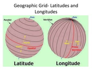
  • 2. The Geographic Grid • The network of parallels of latitudes and meridians of longitudes drawn on a map or a globe is called the Geographic Grid. • The intersection of latitude and longitude at right angle points out the exact position of a place on the Earth’s surface. • There are two reference lines called the equator and the prime meridian, both of which are imaginary lines adopted uniformly by all the countries to avoid confusion.
  • 3. Latitudes A latitude is an angular distance of a place north or south of the equator. The equator is the imaginary great Circle also known as the 0⁰ latitude. It divides earth into northern and southern hemisphere. • Places north of the equator lies in the northern hemisphere and are represented as (⁰N). • Places south of the equator lies in the southern hemisphere and are represented as (⁰S).
  • 5. Latitude North Pole South Pole Lines of latitude are numbered from 0° at the equator to 90° N.L. at the North Pole. Lines of latitude are numbered from 0° at the equator to 90° S.L. at the South Pole. ] [ 90 80 70 60 50 40 20 30 10 90 80 70 60 50 40 20 10 30
  • 6. Latitude The North Pole is at 90° N The South Pole is at 90° S The equator is at 0° latitude. It is neither north nor south. It is at the center between north and south. 40° N is the 40° line of latitude north of the equator. 40° S is the 40° line of latitude south of the equator.
  • 7. Important Parallels Of Latitude 1. The Equator (0⁰) 2. The Tropic of Cancer (23.5⁰N) 3. The Tropic of Capricorn (23.5⁰S) 4. The Arctic Circle (66.5⁰N) 5. The Antarctic Circle (66.5⁰S)
  • 8. Meridians Of Longitude • The lines of longitude are imaginary lines, which join all the places having the same angular distance east or west of the prime meridian. The Greenwich meridian or the prime meridian is the reference line for measuring east- westward distance of the earth. • Prime meridian is taken as 0⁰ meridean.
  • 9. Prime Meridian The Prime Meridian (0°) and the 180° line split the earth into the Western Hemisphere and Eastern Hemisphere. Prime Meridian Western Hemisphere Eastern Hemisphere Places located east of the Prime Meridian have an east longitude (E) address. Places located west of the Prime Meridian have a west longitude (W) address.
  • 10. Longitude • Lines of Longitude run vertically. • They are also called Meridians. • The Prime Meridian is found in Greenwich, England. • The Prime Meridian is 0 degrees Longitude. • Lines of Longitude locate places East or West of the Prime Meridian. • There are 180 degrees of east Longitude, and 180 degrees of west Longitude.
  • 11.
  • 12. Longitude Lines of longitude begin at the Prime Meridian. 60° W is the 60° line of longitude west of the Prime Meridian. The Prime Meridian is located at 0°. It is neither east or west 60° E is the 60° line of longitude east of the Prime Meridian. W E
  • 13. LONGITUDE AND TIME • The world rotates (spins) 360° in 24 hours. 360° / 24 hours = 15° per hour • The world has 24 time zones, each l5° apart. THERE IS A 1 HOUR TIME DIFFERENCE FOR EVERY 15° OF LONGITUDE • Time zones are broad strips that measure 15 degrees wide. • Time zones differ from their neighboring time zones by 1 hour. • The lines of longitudes are used to find the time of any place.
  • 14. • The earth takes 24 hrs to complete one rotation of 360⁰. This gives rise to a time difference of [(24*60)/ 360] = 4min for one degree of longitude. • Therefore , 1. A time difference of four min has to be added for each 1⁰ of longitude towards the east. 2. A time difference of four min has to be subtracted for each 1⁰ of longitude towards west. Local time: the time of a place recognized by the mid-day sun is called the loca’ time. All the places located along a particular longitude (from north pole to south pole) face the overhead sun at the same time.
  • 15. Standard Time: The local time of the central meridian is taken as the standard time for the whole country or a large area. • A large area may be crossed by many meridians of longitude, it means they may have many local times. It would be very difficult for people to keep on setting their watches according to local time of the place. • To avoid such difficulties and confusion, the local time of a central meridian is taken as the standard time for the whole country or a large area. Indian Standard Time (I.S.T.): The 82.5⁰ E longitude is selected as the central meridian of India which passes through Prayagraj and is known as the standard meridian of India.
  • 16. Greenwich Mean Time: • The local time of the Greenwich meridian also known as the prime meridian is considered as the standard time for the whole world is called the Greenwich Mean Time or G.M.T. • All the countries for international travel follow it. Time zones: • Some countries like Russia, Canada, and USA have large longitudinal extension where if a single time is followed as standard time, it will create lot of problems. • So to avoid such confusion, the countries having large east- west extension have to follow more than one time zones. For example , Canada and USA have 6 time zones.
  • 17. Time Zones Of The World
  • 18. International date line • The international date-line, fixed by international agreement, is an imaginary line along the 180⁰ meridian extending from north pole to south Pole. • International date line roughly follows 180⁰ longitude and is not a straight line. -because few countries and islands are located very close to 180⁰ longitude. To keep them wholly on the same side , the international dateline goes zigzag way, passing over seas and oceans only.
  • 19. The Great Circle • If the earth is divided exactly into two halves by a circle with that of the earth’s centre, simultaneo- -usly the radius of the circle should also be equal to that of the earth’s radius, it is called great circle. • The Equator is the greatest possible circle as the earth is bulged at the equator representing the circumference of the earth. • In case of longitudes, we find that any longitude along with its diametrically opposite longitude makes a full circle. So all meridians of longitudes are considered to be great circle.
  • 20. Importance Of The Great Circle • The shortest route between any two places on the earth is always prefered by the navigators and aviators. A route along the arc of a great circle provides the shortest possible route which saves fuel, time, and expenditure. • There are special great circle charts used by the navigators on which these routes are shown as straight lines. As far as possible, the ships and aircrafts follow these routes to make their journey economical. • Sometimes, some countries do not allow the aircrafts to fly over their airspace, so the aircrafts have to deviates from these routes.