
Recomendados
Recomendados
Más contenido relacionado
La actualidad más candente
La actualidad más candente (20)
Destacado
Destacado (11)
Similar a محاضرة
محاضرة
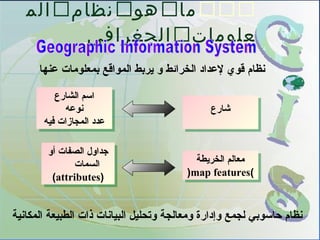
- 1. ماهونظامالم علوماتالجغرافي عنها بمعلومات المواقع يربط و الخرائط لعداد قوي نظام المكانية الطبيعة ذات البيانات وتحليل ومعالجة وإدارة لجمع حاسوبي نظام شارعشارع الشارع اسم نوعه فيه المجازات عدد الشارع اسم نوعه فيه المجازات عدد الخريطة معالم )map features( الخريطة معالم )map features( أو الصفات جداول السمات (attributes) أو الصفات جداول السمات (attributes)
- 2. 1ما هدف لنجاز المناسبة المواقع على العثور - محددة ومعايير شروط على اً اعتماد يقومGIS.المستخدم تدخل دون ،خطوات عدة عبر بمفرده القرار ذلك باكتشاف افتتاح يجوز ل الموقع في مدرسةC المدرسة لنAل بالمسافة عنها تبعد المطلوبة افتتاح يجوز ل الموقع في مدرسةC المدرسة لنAل بالمسافة عنها تبعد المطلوبة الموقعBمناسب مدرسة لفتتاح الموقعBمناسب مدرسة لفتتاح يستخدمGIS:كليهما أو التاليين الهدفين أحد لنجاز قوته ومصدر الجغرافية المعلومات لنظام الساسية الفكرة هذه اً معلم حددت إذا الخريطة على إلى يوصلك فإنه صفاته اً معلم حددت إذا الخريطة على إلى يوصلك فإنه صفاته صفات حددت إذا على يدلك فإنه الخريطة معلم تلك صاحب الصفات صفات حددت إذا على يدلك فإنه الخريطة معلم تلك صاحب الصفات اً موضوع باعتبارها والصفات المعالم مجموعات يدير (theme.) اً موضوع باعتبارها والصفات المعالم مجموعات يدير (theme.) 2الخريطة معالم خصائص عن الستعلم -
- 3. خرائط تقارير بيانية رسومات خرائط تقارير بيانية رسومات MapsMaps GraphsGraphs ReportsReports مكانية بيانات وصفية بيانات مكانية بيانات وصفية بيانات معالجة استفسار تحليل
- 4. المكانية البيانات )Data Spatial( البياناتالوصفية Descriptive Data( مكاني عنصر تصف البيانات من مجموعة هيئة على وتكون المخطط على تظهر ول .نصوص أو جداول عن معلومات تتضمنوشكل موقع في عادة وتخزن الجغرافية المعالم قاعدة تشكل عام وبشكل إحداثيات في الرسومي القسم المكانية البيانات ()الخارطة الجغرافية المعلومات نظام المكان بتغير تتغير ل : مثال مدينة لسكان العمري التوزيع عمره فمن40لن سورية في سنة يصبح41مصر في سنة المكان بتغير تتغير : مثال مدينة في السكانية الكثافة مركز بين الدراسة منطقة حسب تتغير وضواحيها المدينة المعلومات نظام معها يتعامل التي البيانات الجغرافي
- 5. البياناتالمكانية الجغرافية 1( الخطي النموذج -vector:) قسمين إلى بتقسيمها الجغرافية البيانات تمثيل يتم : هيئتين في تمثل الخطي النموذج )vector( النقطي النموذج )raster( قسم رسومي قسم وصفي ظاهرة أي تمثيل يتم مضلع أو خط أو بنقطة بمعرف شكل كل تمييز يتم IDبين للربط يستخدم الوصفية وبياناته الشكل 2( النقطي النموذج -raster:) السطر من لشبكة الفراغ تقسيم يتم والعمدة كمافيالقمار وصور الجوية الصور الصطناعية
- 6. طريق X,Y Rows Columns X,Y X,Y X,Y X,Y الشعاعية الصيغةvector المتريسية الصيغةraster
- 7. الشعاعية الصيغة أصغر تخزين سعة تتطلب العناصر مستوى على التعامل يتم ) التحريرeditingوالتعديل ( الهندسية العناصر عن والستعلم سهل لً طوي زمنا وتتطلب كلفة أكثر واضحة تكون المضلعات حدود .وحادة عام بشكل أدق العلاقات إنشاء يمكن مستوى على الطوبولوجية العناصر المتريسية الصيغة كبيرة تخزين سعة تتطلب مستوى على التعامل يتم الخلية إلى بحاجة والتعديل التحرير ذكية برمجيات تنجزُن و كلفة وأاقل ااقتصادية بسرعة أو ر جّج التد لتمثيل مناسبة ظاهرة في المستمر التغيير ببعد ومتعلقة اقليلة الداقة ) الخليةPixel( طوبولوجية علاقات توجد ل العناصر مستوى على
- 8. عن الخريطة على معلم لي المجاورة المعالم على التعرف يتم اليسار وعلى اليمين على يوجد عما التعرف طريق العلاقاتالمكانية(t opology( التجاورالتجاور
- 10. الحتواءالحتواء الظاهرةBالظاهرة داخل كاملة تقعA معينة منطقة داخل الموجودة البار عدد تحديد الخاصية هذه باستخدام يمكن B A
- 11. نظـامالمعلوماتالجغرافيو علاقتهبالنظمةالخرى GIS CAD CAC RS DBM 1الحاسب بمعونة التصميم أنظمة ـComputer –added design: محدود بشكل ولكن البيانات قواعد إلى الوصول تتيح .محدودة التحليلية إمكانياتها 2الكرتوغرافية النظمة ـComputer Cartography: المكانية العلقات إلى وتفتقر بسيطة فيها المعلومات بنيةtopology. .محدودة التحليلية قدراتها 3البيانات قواعد إدارة أنظمة ـDatabase management systems DBMS):) الوصفية البيانات وتعالج وتجمع تخزن .الجغرافي التحليل إمكانية إلى وتفتقر محدودة الرسومية إمكانياتها 4بعد عن الستشعار أنظمة ـRemote sensing systems: النقطية البيانات وتعالج وتخزن تجمعraster data البيانات معالجة على القدرة إلى النظمة هذه تفتقر( الشعاعيةvector data) .محدودة الوصفية البيانات مع ربطها إمكانية ليحلنظامالجغرافي المعلوماتمحلالنظمةالسابقةفي أداءوظائفهابليستفيدمنبعضإمكانياتهالجراء التحاليلالجغرافيةالمختلفة.
- 12. الستعلمالمكانيspatial queries ـ؟ ما بلد في السكان كثافة ؟ للسكان تزايد نسبة بأكبر يتصف الذي البلد ماهو ـ حد عن فيها السكان كثافة تزيد التي البلدان ماهي - ؟ معين البطالة نسبة السكان تزايد نسبة السكان عدد العاصمة البلد إسم يتصف الذي البلد مع تتجاور التي البلدان ماهي ـ ؟ سكان تزايد نسبة بأكبر حد عن فيها السكان كثافة تزيد التي البلدان ماهي ـ ؟ أوروبا قارة في تقع والتي معين المتوسط البيض للبحر المتاخمة البلدان ماهي ـ ؟ معين حد عن فيها البطالة نسبة تزيد والتي ؟ السابقة البلدان عواصم بين طريق أقصر ماهو ـ استفساراتاستفسارات .الظواهر توزع توضيح في يفيد الخريطة مع الربط )بيانات (قاعدة)بيانات (قاعدة الخريطة مع لربط ليحتاج ,مستوية (إحداثيات المواقع عن بيانات يتطلب )....الخ التجاور علقات ,وعرض طول خطوط بالموقع متعلقة غير )spatial queries A( بالموقع متعلقة )spatial queries(
- 13. ؟ التالي الموقع في يوجد ماذا What is at…? .معين لموقع الخاصة المواصفات لتحديد البيانات قاعدة في البحث يتضمن : أمثلة ؟ التالي الموقع سكان عدد ماهو . ؟ التالي الموقع في التربة نوع ماهو . ؟ التالي الموقع في التربة ملوحة نسبة ماهي . الستعلمعنخصائصم عالمالخريطةالموقع عن الستفسارLocation Question الموقع عن الستفسارLocation Question
- 14. ؟ يلي ما يتحقق أين Where is it……? الشرطي التستفسارCondition Question الشرطي التستفسارCondition Question
- 15. المحافظة النموالسكان المناطقالمساحة دمشق ادلب اللقذقية حماة حمص حلب 4.039000 18.482 842.220 6 3.751.582000 5 10.163 3.111.533000 992000 2.36 2.297 4 1.396000 3.48 6.097 5 919.018 3.61 1.541000 4.59 دمشق حمص : التالية الشروط تحقق التي المحافظات هي ما من أكثر السكان عدد1.540000من أكثر النمو نسبة نسمة3.70% من أكبر المساحة19000كم2عددمن أكثر المناطق7مناطق
- 17. مسار؟ ( ... الخ , أفضل , أتسرع , أقصر ) هو ما ؟ التاليين الموقعين بين مسار أقصر ماهو . معامل ت على اَ اعتماد ) التاليين الموقعين بين مسار أتسرع ماهو . ؟ ( البيانا ت قاعدة في للطرقا ت معرفة وازدحام تسرعة الطبية للوحدا ت المختلفة والمواقع ما موقع بين مسار أقصر ماهو . ؟ المنطقة في المسارا ت عن التستعلم)Routing Question( المسارا ت عن التستعلم)Routing Question(
- 18. الزمن مع تحدث التي التغيرا ت مراقبة يتضمن ؟ منذ تغير الذي ما What has change since……? :أمثلة عام مروية تكن لم والتي اَ حالي المروية الراضي ماهي .1980؟ عام بين ملوحتها نسبة ازداد ت التي الراضي .ماهي1980و1985بنسبة من أكثر10%؟ عامي بين فيه الزدحام معامل تضاعف التي الشوارع ماهي .1990و2000؟ التغيرا ت عن التستفسارTrend Question التغيرا ت عن التستفسارTrend Question
- 19. مختلفة تواريخ في والخرائط الصور من مجموعة مقارنة الحادث التغيير مدى و الشواطىء تآكل تطور متابعة .الزمن مر على فيها
- 20. ..؟ يتوزع كيف What is the pattern…..? , أخرى ظواهر مع وارتباطها اَ مكاني ما ظاهرة توزع مراقبة يتضمن الظواهر ارتباط لدراتسة ( البيئة مثل ) العلمية للرغراض ةَ عاد ويستخدم .انتشارها آلية وفهم البعض بعضها مع :أمثلة التوزع مع وارتباطها اَ مكاني الطفال بين الوفيا ت نسبة توزع . الدخل لمستوى المكاني؟ الفردي مع نسبتهم ازدياد ترتبط وهل مكانيا السرطان مرضى يتوزع كيف . ؟ النووية المواقع من القرب ) التوزع التستفسارعنPatterns Question( ) التوزع التستفسارعنPatterns Question(
- 21. :أمثلة البحار في المياه منسوب ارتفع إذا تستغمر التي المناطق هي ما .1m؟ ...؟ إذا تسيحدث ماذا ?...What if .تأثيرها في والبحث معينة حادثة نمذجة يتضمن والذي النقطتين بين يصل طريق نفذ إذا العقارا ت من تستستملك التي المساحا ت . AوBبعرض10m؟ الشارع في السير كثافة تستصبح كم .Aالمرور منع إذافيالشارعB؟ ) النمذجة طريق عن التستعلمModeling:( ) النمذجة طريق عن التستعلمModeling:(
- 22. بعد على الواقعة المنازل عدد كم -100؟ الماء مصدر على متر بعد على الواقعة الراضي قطع هي ما -50؟ الطريق من قدم التقريبي التحليل)Proximity Analysis( التقريبي التحليل)Proximity Analysis(
- 23. مكوناتنظـامالمعلومات الجغرافي 1الل ت -Hardware) ( 2) البرامج -Software( 3البيانا ت -Data(( ) وصفية بيانا تTabular Data( ) مكانية بيانا تSpatial Data( 4) الخشخاص -People( 5) الوتسائل -Procedure(
- 25. بين من لً م مث السكان عدد تسمة اتستخدام الجغرافي المعلوما ت نظام يستطيع فيها السكان لعدد اً متبع المختلفة باللوان الدول لترميز السما ت الموضوعية الخرائط إنتاج)thematic mapping:( المعالم مظهر بتغيير رتسومي أتسلوب في الوصفية البيانا ت إظهار اً محوضو أكثر المعلوما ت يجعل مما : لً م مث المرورية الكثافة ذا ت الطرق لترميز عريضة خطوط اتستخدام - العالية على مر التي المياه أنابيب لترميز الزرق اللون اتستخدام - من أكثر تركيبها20.اً معام
- 26. ) المكاني التوليدspatial interpolation:( ظاهرة لي التساوي خطوط خرائط إنشاء يستطيعGISطبقة إضافة بتوليدها التسوية منحنيا ت طبقة في تسما ت من اً ميآل وظيفة باتستخدام أخرى نقاط المكاني التوليد.
- 27. الرقمي الترتفاع نموذج وتحليل انتاج الرقمي الترتفاع نموذجDEM) ) Elevation Model Digital الترتفاع متباينة الترضية للتضاتريس ترقمي تمثيل عن عباترة هو فوائده الجغرافي التوزيع تمثيل * أبعاد بثلةثة للظواهر )X,Y.Zمن إليها والنظر ( مختلفة زوايا النحداترات توضيح * على بالعتماد والترتفاعات اللوني التدترج صفة
- 28. ) التراكبoverlay:( .الخريطة على جديدة طبقة لنتاج أكثر أو طبقتين تركيب بزتراعة الخاصة التشتراطات بها تتوفر التي المناطق هي ما - ... الترز أو القطن بعمل الجغرافي المعلومات نظام يقوم )Overlayمن مجموعة بين ( الى للوصول بالتربة الخاصة الطبقات الخصائص جميع بها تتجمع التى الطبقة للتربة المطلوبة
- 29. أفضل قراترات اتخاذ 1اً حفاظ رئيسي طريق على الموقع يكون أل - التليميذ سليمة على 2يمدارس خديمة نطاق داخل الموقع يكون أل - القائمة الساسي التعليم 3الضجيج أيماكن عن بعيد الموقع يكون أن - والتلوث 4طبيعة ذات أراضي على الموقع يتعدى أل - دينية يمباني أو خاصة 5كثافات فيها توجد يمنطقة في الموقع يكون ان - يمعينة بقيمة تليميذ : المدرسة يمكان إختيار يمعايير
- 31. استخداماتنظمالمعلوماتا لجغرافيةفىالمجالتالمخت لفة الشبكات تحليل)network analysis( ( كهرباء – مياه - طرق ) 1-مساتر أفضل إيجاد 2الخريطة على نقطتين بين الرحلة زمن لمعرفة الطرق تشبكة تحليل - ما طريق سلوك عند 3من اً انطلق ب النقطة إلى تقود أن يمكن التي الطرق تحديد -النقطةأ 4التتبع -)Tracing( المياه مواسير إحدى فى كسر حدوث عند ستتأةثر التى المناطق تحديد الكهرباء محولت أحد فى عطل حدوث عند أو معينة نقطة عند
- 32. الزمات إداترة الوبئة انتشاتر - العاصير - الزلزل - الفيضانات ) ( الخ ... المجاعات - العامة -الضطرابات القراتر لمتخذي الجغرافية المعلومات نظم تتيح الحيوية للمعلومات والمرئى السريع الوصول خطط تطوير على يساعد مما , الزمة موقع عن للتعامل العمل لفريق ترسل أو تطبع التى العمل تفعيل و تنسيق على تساعد وبالتالى الزمة مع .الطواترئ جهود
- 33. الطاترئة الطبية الخدمات الجغرافية المعلومات نظم تتيح 1-:تحديد خلل من الطاترئة الطبية الخدمات نظام استجابة سرعة مكان الى إسعاف وحدة -أقرب الحادث عن المبلغ التصال إلى للوصول البديلة الطرق -أقصر الحادث مكان 2-انتشاتره قبل وباء أو لداء عدوى انتشاتر ومدى سرعة معرفة أو المرض انتشاتر لتجنب السليم التخطيط على يساعد مما الفعلى . الوباء
- 34. العمرانى التخطيط ( أمنية....الخ و ,)تعليمية,وصحية المختلفة الخدمات أداء تقييم - توزيع لعادة المحرومة والمناطق المخدمة المناطق لتحديد فيها الخدمات معينة لمنطقة الراهن بالوضع المقترح التخطيط مقاترنة -. التطوتر متابعة طريق عن للتجمعات العمرانى النمو اتجاهات تحديد - .العمراني النمو و المعايير على بناء العمرانى التجمع عناصر مواقع افضل اختياتر - المختلفة
- 35. خطواتبناءنظام معلوماتجغرافى 1المستخدمين احتياجات تحليل - وماهي النظام لمستخدمي بالستماع للنظام المصممون يقوم من ومطالبهم طموحاتهم وماهي عملهم طريقة وما مشاكلهم النظام هذا
- 36. 480585.5, 3769234.6 483194.1, 3768432.3 485285.8, 3768391.2 484327.4, 3768565.9 483874.7, 3769823.0 480585.5, 3769234.6 483194.1, 3768432.3 485285.8, 3768391.2 484327.4, 3768565.9 483874.7, 3769823.0 mapsmaps GPSGPS GIS DataCoordinatesCoordinates Satellite imagesSatellite images cadcad الجوية الصوترالجوية الصوتر الجدولية البيانات والحصائية الجدولية البيانات والحصائية 2البيانات جمع -)Data Collection(
- 37. ضوئي ماسحالرقمي التحويل جهاز لم إذا ،خريطة في المعلومات تحليل الجغرافية المعلومات نظام يستطيع ل نقوم لذا , قراءتها الحاسب يستطيع ترقمية هيئة في البيانات هذه تكن يطلق العملية وهذه ترقمية ملفات إلي وترقية خرائط من البيانات بتحويل الرقمي التحويل عملية عليها)Digitizing( 3) البيانات إدخال -Data Input( :التالية الفوائد تؤدي الترقيم عملية 1والتشوهات التغييرات من المخططات حفظ - 2مختلفة وبمقاييس محددة لجزاء الطباعة إمكانية - 3المجاوترة المناطق دمج إمكانية - 4المخططات هذه على هندسية تحليلت إجراء إمكانية - 5في أو الحاسب ذواكر في المخططات من كبير عدد تخزين سهولة - تجعلها أماكن في الوترقية المخططات تخزين من لً بد المدمجة القراص والغباتر للهواء عرضة
- 39. الشكل ذو الضرض سطح من جزء وضع كيفية :هو الخريطة إسقاط للعبعاد تشوهات حدوث دون مسطحة وضرقة على الكرويأو الكشكالأوالمساحاتأو.. التجاهات 4والسقاطات المقاييس توحيد - محدد لتستخدام مناتسب التسقاط أنواع من نوع كل اتسطواني مسقط مخروطي مسقط اتجاهي مسقط Geographic Coordinate System Universe Transverse Mercator
- 40. الجيوديزي النظام الضرض سطحالضرض سطح نظرية عبإستخدام الضرض كشكل NAD27 نظرية عبإستخدام الضرض كشكل NAD27 نظرية عباستخدام الضرض كشكل NAD83 أو WGS84 نظرية عباستخدام الضرض كشكل NAD83 أو WGS84 للضرض الحقيقي الشكل منتظم غير عبيضوي للضرض الحقيقي الشكل منتظم غير عبيضوي الضرض مركزالضرض مركز +
- 42. UTM NAD27UTM NAD27 UTM NAD83UTM NAD83
- 43. عبالتى البيانات قواعد من غيرها عن الجغرافية البيانات قاعدة تتميز 1جغرافيا المكان محددة البيانات - 2خصائص ) المكانية وغير المكانية البيانات عبين ضرعبط هناك - ( المكانية البيانات 3الجغرافية العناصر اتصال كيفية يعنى وهو : الطوعبولوجى - عبغيرها 5البيانات قواعد إداضرة -)Data Management(
- 44. 6والتحليل الستفساضر -)Data Analysis and Querying( 7بإنتظام عليه المستمرة التحديثات واجراء النظام صيانة -
- 45. تطبيقي مثال نقطتين عبين (المثل )الطريق إيجاد عبركانية صخوضر عبمناطق مروضره عبسبب النزل ق يسبب الحالي الطريق الشروط 1الوديان و الجبال مناطق عن المكان قدر التبتعاد . و الحفر كلفة تزيد لنها الردم 2.البركانية الصخور مناطق عن المكان قدر التبتعاد . 3.البحيرات و الغاتبات مناطق عن المكان قدر التبتعاد . 4المكان قدر اً حالي الموجود الطريق محاذاة محاولة . التستفادة و الكلفة لتقليلالساتبقة الجهود من يلي تبما نقوم المنطقة خريطة ضمن و الجغرافي المعلومات نظام في 1النخفاضات و الرتفاعات توزع طبقة إدخال . 2الحالي الطريق طبقة إدخال ..
- 46. 3.النباتي الغطاء توزع طبقة إدخال .
- 47. 4.الترتبة توزع طبقة إدخال .
- 48. الشروط يقية إدخال عبعد :الحل عبإيجاد الجغرافي المعلومات نظام يقوم محققة الساتبقة الشروط المكان قدر
- 49. عليها يطبق التي المساحة على تعتمد ضخمة لميزانية النظام يحتاج - تطبيقها المطلوب والوظائف وسريعة قوية حاسب لجهزة البرامج هذه وحاجة للبرامج العالية الكلفة - مشاضريع هكذا لداضرة الخبرة ذوي الكشخاص قلة - ظروف في المحفوظة الخرائط معظم تلف نتيجة البيانات استخراج صعوعبة - سيئة على العتماد الكثيرين يفضل حيث الحديثة التكنولوجيا من الدائم التخوف - كبيرين وجهد وقت كلفت وإن القديمة الساليب معوقات
- 50. لخوض مضطرين أننا إل العراقيل كل عبرغم : منها عديدة لسباب النظام هذا غماضر 1أكملت التي المتطوضرة الدول مع العلمية الهوة إتساع تجنب - أضراضيها كل على النظام هذا تطبيق 2تلفها قبل المتبقية والخرائط البيانات من انقاذه مايمكن انقاذ - عبالكامل
Notas del editor
- الخرائط الموضوعية خرائط تركز بياناتها على غرض بعينه تعني :إظهار البيانات الوصفية في أسلوب رسومي بتغيير مظهر المعالم مما يجعل المعلومات أكثر وضوحاً مثلاً : - استخدام دوائر أكبر لترميز المدن ذات عدد السكان الأكبر - استخدام خطوط عريضة لترميز الطرق ذات الكثافة المرورية العالية
- <number>
- يشوه مسقط ماركيتور كل من الشكل والمسافة والمساحة بعيداً عن خط الاستواء ولكنه يحتفظ بالاتجاه صحيحاً.
- <number> Datums and datum conversion A horizontal datum is a reference frame used to locate features on the earth’s surface. It is defined by an ellipsoid and that ellipsoid’s position relative to the earth. There are two types of datums: earth-centered and local. An earth-centered datum has its origin placed at the earth’s currently known center of mass and is more accurate overall. A local datum is aligned so that it closely corresponds to the earth’s surface for a particular area and can be more accurate for that particular area. Within both of the basic types of datums, you can have several global and local datums. Because datums establish reference points to measure surface locations, they also enable us to calculate planar coordinate values when applying a projection to a particular area. Ellipsoid The earth is often treated as a sphere to make mathematical calculations easier; however, its shape is actually an ellipsoid. Rotating an ellipse about an axis forms an ellipsoid. An ellipsoid is like a flattened circle with radius lengths along its major and minor axes of length a and b, respectively. The diagram shows that the ellipsoid is symmetric when divided at the equator (i.e., the southern hemisphere and the northern hemisphere are identical in shape). This is not strictly correct, because the earth is slightly pear-shaped; however, the difference in shape between the hemispheres is very slight.