
Recomendados
Más contenido relacionado
La actualidad más candente
La actualidad más candente (20)
Similar a Atmospheric Pressure and Winds: Types, Causes and Effects
Similar a Atmospheric Pressure and Winds: Types, Causes and Effects (20)
Más de Saloni777
Más de Saloni777 (14)
Último
Último (20)
Atmospheric Pressure and Winds: Types, Causes and Effects
- 2. Atmospheric Pressure • The weight exerted by the column of the air per unit area on a fixed time is called atmospheric pressure. • It is measured with the help of barometer. • Its unit is millibars(mb). • The normal atmospheric pressure value is 1013.25 mb. • An isobar is the line joining places having equal air pressure.
- 3. Importance of Atmospheric Pressure • 1.Changes in temperature brings changes in atmospheric pressure and causes air to blow to balance the temperature. This horizontal movement of air is called wind.(Winds move from high pressure area(low temperature) to low pressure area(high temperature) to balance) • Winds transport from one area to another, transfers heat and becomes the source of precipitation in form of rain, snow. • It is one of the significant factor in weather forecasting.
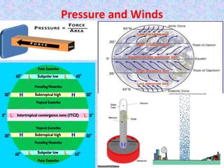
- 4. Horizontal Distribution Of Atmospheric Pressure. • The distribution of atmospheric pressure across latitudes is called Horizontal Distribution of Atmospheric Pressure. There are seven pressure belts across latitudes. • 1. Equatorial Low Pressure Belt: • It extends 10°N and 10°S of Equator. • Low pressure is present in this layer due to high temperature near equator. • The air in this belt have high vapour content . • Earth rotation is maximum near equator because of which air pushes in all directions. • Due to calm air movements in this pressure belt, is called Doldrums.
- 5. • 2.Sub-Tropical High Pressure Belts: • It extends 35°N and 35°S of Equator. • The warm air which rises from the equator, cools down as a result of which temperature decreases and pressure turn to be high. • Large mass of air move from polar areas also decreases the temperature of these areas which in turn increases the pressure in these areas. • The fast winds flow in these areas and that is why it is called Horse latitudes.
- 6. • 3. Sub- Polar Low Pressure Belts: • It extends 45°N and 45°S of Equator. • Warm ocean currents from tropical and sub tropical areas carry lot of heat to this areas and develop high temperature and low pressure conditions there. • Due to rotation of the Earth, winds get deflected in other directions as a result of which low pressure is present in this latitudes. • 4. Polar High Pressure Belts: • It extends 80°N and 80°S of poles. • Temperature remains below freeing point in this layer because of which pressure conditions are high in this areas.
- 7. Winds, its Types and Forces determining it • Air is present in the atmosphere but the horizontal movement of air is called wind. • The direction and speed of wind is controlled by various factors like: • 1. Coriolis Force or Coriolis Effect: • Due to rotation of the Earth, winds do not cross isobars but they are deflected in different direction. • Winds get deflected right in the northern hemisphere and left in the southern hemisphere. This is called as Coriolis Force. • Coriolis Force is maximum near poles and minimum near Equator.
- 8. • 2. Pressure Gradient Force: • The rate of change of pressure per unit distance is called pressure gradient and this force which moves the wind is called pressure gradient force. • Greater the pressure gradient force, greater wil be the wind speed. • 3.Land friction: • Changes on the earth surface causes changes in the speed and direction of wind. Wind speed is smooth over ocean surface where there is no obstruction. • 4. Geostropic Wind: When there is no friction over surface, Pressure Gradient Force and Coriolis Force balances each other and the wind blows parallel to Isobars. This wind is called Geostropic Wind.
- 9. Types of Winds • I. Planetary Winds: • These winds are also called permanent winds because they blow over vast area throughout the year in a particular direction. They are further of three types: • A)Trade winds: • 1. these winds blow from Sub tropical high pressure belt to Equatorial low pressure belt. • 2.Due to Coriolis force , these winds get deflected right in the northern hemisphere and left in the southern hemisphere. These winds north eastern trades in northern hemisphere and south eastern trades in southern hemisphere . Therefore they are called as Easterlies. • 3. The Northeastern and Southeastern winds converge near Equator which is called as Inter Tropical Convergence Zone(ITCZ) an d on the line of convergence(meeting ) of two winds rainfall occurs. • 4.These winds blow in a same direction at a same speed and is therefore helpful for traders while moving from on place to another. • 5.They move with the speed of 15-25 km per hour.
- 10. • B) Westerlies:- • 1. These winds blow from Sub tropical high pressure belt toward Sub polar low pressure belt. • 2. Under the influence of Coriolis Force, they blow from SW to NE in northern and NW to SE in southern hemisphere. • 3.They are called Westerlies because they blow from western side from both the hemispheres. • 4.The blow from warm areas to cold areas and thus cause rainfall on western part of continents. • 5. Due to vast expanse of oceans in the southern hemisphere, these winds blow a very high speed called as Roaring Forties, Furious Fifties, Shreiking Sixties.
- 11. • C. Polar Winds: • 1.They blow from Polar High Pressure Belt to Sub-Polar Low Pressure Belt and is called as Polar Winds. • 2.They blow from NE to SW in northern hemisphere and SE to NW in Southern hemisphere due to Coriolis Force. • 3. They originate from cold areas and are cold winds. • 4. Since they originate from cold areas, they do not cause much rainfall.
- 12. II. LOCAL WINDS • These winds blow due to difference in heating of land and sea. They are of following types: • A. LAND And SEA BREEZE: • 1.During day time, land gets heated as a result of which temperature of land becomes warm, air above that becomes light and rises and creates an area of low pressure. Wind move from sea to land and is called as Sea Breeze. • 2.During night time, land which was heated during day gets cooled down earlier as result of which low temperature and high pressure develops over land .Winds move from land to sea to balance the temperature and pressure conditions and is called as Land breeze.
- 13. • 2. Mountain and Valley Breeze • During day mountain gets heated as a result of which high temperature and low pressure conditions are present. To balance this low pressure conditions, breeze moves from valley to mountain which is called Valley Breeze. • During night time, mountain slopes gets cooled down very fast as a result of which high pressure conditions develop over there. Breeze moves from mountain to valley to balance the low pressure conditions in valley. It is called as Mountain Breeze.
- 14. • 3. Loo: It is a hot and local wind of northern India. It can be felt in the month of May and June when the temperature is between 40-50° C • 4.Foehn: it is a dry and warm wind which develops over the leeward side of Alps mountain in Europe . This wind helps in animal grazing and promoting ripening of grapes. • 5.Chinook: it is a warm wind blowing in slopes of Rockies Mountain in USA and Canada. It is also called as snow eater as it helps in melting snow and keeping the grasslands clear. • 6. Mistral: it is a cold wind which blows from Alps mountain in France and move towards Mediterranean Sea.
- 15. Air It is present in the atmosphere and can have different temperature and humidity. It can start flowing where there is difference in temperature and pressure conditions. It helps us in studying variations of atmosphere. Air mass It is large mass of air with uniform properties of temperature and humidity. It starts flowing from the source region. It helps in studying cyclones and anticyclones.
- 16. FRONTS AND ITS TYPES • The contact line between two different air masses of different properties is called Front. • It is of two types: • 1.Warm front: When the warm airmass moves towards cold airmass, it results in forming warm front. • 2.Cold Front: When the cold airmass moves towards warm airmass, it is called Cold front.
- 17. Cyclone and Anticyclone • Cyclone: • It is an area of low pressure surrounded by high pressure. • Wind moves from all sides to centre. • Wind moves anticlockwise in northern and clockwise in the southern hemisphere. • Anticyclone: • It is an area of high pressure surrounded by low pressure. • Wind moves from centre to all sides. • Wind moves clockwise in the northern and anticlockwise in the southern.
- 18. Type of Cyclone Tropical Cyclone They are circular in shape. These cyclones develop over seas. They affect the smaller areas. Wind velocity is higher in tropical cyclone They are prevalent in summer season Extra Tropical Cyclone or Temperate Cyclone They are V shape. These cyclones develop over land and seas. They affect the larger areas. Wind velocity is less in this cyclone. They are prevalent in winter sason.
- 19. • Tropical Cyclones are known by different names in different countries: • 1.Hurricanes in West Indies and Florida • 2. Typhoons in Japan, China and Philippine Islands. • 3. Tornadoes in USA and Mexico. • 4. Willy Willies in Australia. • 5. Cyclones in Bay of Bengal and Arabian Sea.